



m 1 revision imported |
m improve intro for accuracy for consistency |
||
| (2 intermediate revisions by 2 users not shown) | |||
| Line 1: | Line 1: | ||
{{Short description|Region in northern India and southern Nepal}} | |||
The '''Terai''' or '''Tarai''' is a region of northern [[India]] and | {{Other uses}} | ||
{{Special characters}} | |||
{{Use dmy dates|date=February 2020}} | |||
{{Infobox ecoregion | |||
|name =Terai | |||
|image =Terai nepal.jpg | |||
|image_size = | |||
|image_alt = | |||
|caption =Aerial view of Terai plains near Biratnagar, Nepal | |||
|map =<!-- Nepal topo en.jpg --> | |||
|map_size = | |||
|map_alt = | |||
|map_caption = <!-- Mostly the light green area indicates the Terai in Nepal --> | |||
|biogeographic_realm = [[Indomalayan realm]] | |||
|global200 = [[Terai-Duar savanna and grasslands]] | |||
|countries =Nepal, India | |||
|elevation ={{convert|67-300|m|abbr=on}} | |||
|soil = alluvial | |||
|rivers = [[Sharda River]], [[Karnali River]], [[Gandaki River]], [[Koshi River]] | |||
|climate = tropical savanna climate | |||
|animals = [[gharial]], [[mugger crocodile]], [[king cobra]] | |||
|bird_species = [[Bengal florican]], [[lesser adjutant]], [[swamp francolin]], [[white-rumped vulture]], [[Oriental darter]], [[sarus crane]] | |||
|mammal_species = [[Indian rhinoceros]], [[Asian elephant]], [[gaur]], [[blackbuck]], [[tiger]], [[leopard]], [[jungle cat]], [[fishing cat]], [[leopard cat]], [[smooth-coated otter]], [[large Indian civet]], [[Asian palm civet]], [[small Indian civet]], [[hispid hare]] | |||
|biome = | |||
|border = | |||
|borders = | |||
|area = | |||
|region_type = | |||
|coordinates = | |||
|geology = | |||
|conservation = | |||
|habitat_loss = | |||
|habitat_loss_ref = | |||
|protected = | |||
|protected_ref = | |||
|embedded = | |||
}} | |||
The '''Terai''' or '''Tarai''' is a lowland region in parts of southern [[Nepal]] and northern [[India]] that lies to the south of the outer foothills of the [[Himalayas]], the [[Sivalik Hills]] and north of the [[Indo-Gangetic Plain]]. | |||
This region is characterised by tall [[grassland]]s, scrub [[savannah]], [[Shorea robusta|sal]] [[forest]]s and clay rich [[swamp]]s. In [[North India]], the Terai spreads from the [[Yamuna River]] eastward across [[Haryana]], [[Uttarakhand]], [[Uttar Pradesh]], [[Bihar]] and [[West Bengal]]. The Terai is part of the [[Terai-Duar savanna and grasslands]] [[ecoregion]].<ref name=Johnsingh2004>{{cite report |author1=Johnsingh, A. J. T. |author2=Ramesh, K. |author3=Qureshi, Q. |author4=David, A. |author5=Goyal, S. P. |author6=Rawat, G. S. |author7=Rajapandian, K. |author8=Prasad, S. |name-list-style=amp |year=2004 |title=Conservation status of tiger and associated species in the Terai Arc Landscape, India. RR-04/001 |publisher=Wildlife Institute of India |location=Dehradun |url=http://www.nfwf.org/AM/Template.cfm?Section=Home&TEMPLATE=%2FCM%2FContentDisplay.cfm&CONTENTID=8052 |access-date=31 December 2017 |archive-date=13 April 2020 |archive-url=https://web.archive.org/web/20200413022648/http://www.nfwf.org/AM/Template.cfm?Section=Home&TEMPLATE=%2FCM%2FContentDisplay.cfm&CONTENTID=8052 |url-status=dead}}</ref> | |||
Nepal's Terai stretches over {{cvt|33998.8|km2}}, about 23.1% of Nepal's land area, and lies at an elevation of between {{cvt|67|and|300|m}}. The region comprises more than 50 [[wetland]]s. North of the Terai rises the [[Bhabar]], a narrow but continuous belt of forest about {{cvt|8|–|12|km}} wide.<ref name="nbrb07">{{Cite book |author1=Bhuju, U. R. |author2=Shakya, P. R. |author3=Basnet, T. B. |author4=Shrestha, S. |name-list-style=amp |title=Nepal Biodiversity Resource Book. Protected Areas, Ramsar Sites, and World Heritage Sites |place=Kathmandu |publisher=International Centre for Integrated Mountain Development; Government of Nepal, Ministry of Environment, Science and Technology; United Nations Environment Programme, Regional Office for Asia and the Pacific |year=2007 |url=http://lib.icimod.org/record/7560/files/Nepal%20Biodiversity%20Resource%20Book.pdf}}</ref> | |||
== | ==Etymology== | ||
{{ | The [[Urdu language|Urdu]] word {{Nq|ترائی}} tarāʼī means "lands lying at the foot of a watershed" or "on the banks of a river; low ground flooded with water, valley, basin, marshy ground, marsh, swamp; meadow".<ref>{{cite book |author=Platts, J. T. |year=1884 |chapter=ترائي तराई tarāʼī |page=316 |chapter-url=http://dsalsrv02.uchicago.edu/cgi-bin/philologic/getobject.pl?c.2:1:3349.platts |title=A dictionary of Urdu, classical Hindi, and English |publisher=W. H. Allen & Co. |location=London }}{{Dead link|date=August 2025 |bot=InternetArchiveBot |fix-attempted=yes }}</ref> In [[Hindi]], the region is called {{lang|sa|तराई}} 'tarāī' meaning "foot-hill".<ref>{{cite book |author=Bahri, H. |year=1989 |title=Learners' Sanskrit-English dictionary — Siksarthi Hindi-Angrejhi sabdakosa |chapter=tarāī तराई |page=280 |chapter-url=https://dsalsrv04.uchicago.edu/cgi-bin/app/bahri_query.py?qs=%E0%A4%A4%E0%A4%B0%E0%A4%BE%E0%A4%88 |publisher=Rajapala |location=Delhi }}{{Dead link|date=August 2025 |bot=InternetArchiveBot |fix-attempted=yes }}</ref> In [[Nepali language|Nepali]], the region is called {{lang|ne|तराइ}} 'tarāi' meaning "the low-lying land, plain" and especially "the low-lying land at the foot of the Himālayas".<ref>{{cite book |author=Turner, R. L. |year=1931 |chapter=तराइ tarāi |page=274 |chapter-url=https://dsalsrv04.uchicago.edu/cgi-bin/app/turnernepali_query.py?qs=%E0%A4%A4%E0%A4%B0%E0%A4%BE%E0%A4%87&searchhws=yes |title=A Comparative and Etymological Dictionary of the Nepali Language |publisher=K. Paul, Trench, Trubner |location=London}}</ref><ref name="Regmi1963">{{cite book |last=Regmi|first=M. C. |author-link=Mahesh Chandra Regmi |title=Land tenure and taxation in Nepal |volume=1 |url=https://books.google.com/books?id=02YwAAAAMAAJ|year=1963 |location=Berkeley |publisher=Institute of International Studies, University of California |page=1}}</ref> It has been described as "low, marshy ground".<ref>{{cite book |last=Whelpton |first=J. |author-link=John Whelpton |title=A History of Nepal |year=2005 |publisher=Cambridge University Press |location=Cambridge, United Kingdom |isbn=978-0-521-80470-7 |chapter=Environment, state and society in the central Himalayas to 1743 |pages=6–34 |chapter-url=https://books.google.com/books?id=KoNT6tjk9mQC&pg=PA8}}</ref> | ||
[[ | == Geology == | ||
[[ | The Terai is crossed by the large perennial Himalayan rivers Yamuna, Ganges, [[Sarda River|Sarda]], [[Ghaghara|Karnali]], [[Narayani River|Narayani]] and [[Kosi River|Kosi]] that have each built [[alluvial fans]] covering thousands of square kilometres below their exits from the hills. Medium rivers such as the [[West Rapti River|Rapti]] rise in the [[Mahabharat Range]]. The geological structure of the region consists of old and new [[alluvium]], both of which constitute alluvial deposits of mainly sand, [[clay]], [[silt]], gravels and coarse fragments. The new alluvium is renewed every year by fresh deposits brought down by active streams, which engage themselves in [[Flood|fluvial action]]. Old alluvium is found rather away from river courses, especially on uplands of the plain where [[silting]] is a rare phenomenon.<ref>{{Cite book |author=Das, K. K. L., Das, K. N. |editor=Sharma, H. S. |volume=3 |title=Perspectives in Geomorphology |location=New Delhi |publisher=Naurung Rai Concept Publishing Company |year=1981 |chapter=Alluvial morphology of the North Bihar Plain – A study in applied geomorphology |pages=85–105 |chapter-url=https://books.google.com/books?id=6j1OC4P31ukC&pg=PA85}}</ref> | ||
{{ | A large number of small and usually seasonal rivers flow through the Terai, most of which originate in the Sivalik Hills. The soil in the Terai is alluvial and fine to medium textured. Forest cover in the Terai and hill areas has decreased at an annual rate of 1.3% between 1978 and 1979, and 2.3% between 1990 and 1991.<ref name="nbrb07"/> | ||
With deforestation and cultivation increasing, a permeable mixture of gravel, boulders and sand evolves, which leads to a sinking [[water table]]. But where layers consist of clay and fine sediments, the groundwater rises to the surface and heavy sediment is washed out, thus enabling frequent and massive floods during [[Monsoon of South Asia|monsoon]], such as the [[2008 Bihar flood]].<ref>{{cite conference |title=The Public Benefits of Private Technology Adoption |author1=Bhargava, A. K.|author2=Lybbert, T. J.|author3=Spielman, D. J. |year=2014 |url=http://ageconsearch.umn.edu/bitstream/170682/2/AAEA%20Submission.pdf |conference=Selected Paper prepared for presentation at the Agricultural & Applied Economics Association's Annual Meeting, July 2014 |location=Minneapolis, Minnesota}}</ref> | |||
== Geography == | |||
In India, the Terai extends over the states of Haryana, Uttarakhand, Uttar Pradesh, Bihar and West Bengal. These are mostly the districts of these states that are on the [[India–Nepal border]]:<ref name=Johnsingh2004/> | |||
* Haryana: [[Panchkula district]] | |||
* Uttarakhand: [[Haridwar district]],<ref name=Tewari2013>{{cite journal |author1=Tewari, R. |author2=Rawat, G.S. |year=2013 |title=Studies on the food and feeding habits of Swamp Deer (''Rucervus duvaucelii duvaucelii'') in Jhilmil Jheel Conservation Reserve, Haridwar, Uttarakhand, India |journal=ISRN Zoology |issue=ID 278213 |doi=10.1155/2013/278213 |volume=2013 |pages=1–6 |doi-access=free}}</ref> [[Udham Singh Nagar district]], [[Champawat district]], and [[Nainital district]]<ref name=Ranjan2010>{{cite book |author=Ranjan, G. |year=2010 |title=Global Warming, Human Factors and Environment: Anthropological Perspectives |editor1=Sharma, K. |editor2=Mehta, S. |editor3=Sinha, A.K. |publisher=Excel India Publishers |place=New Delhi |chapter=Industrialization in the Terai and its Impact on the Bhoksas |pages=285–292 |chapter-url=https://www.researchgate.net/publication/236009517}}</ref> | |||
* Uttar Pradesh: [[Pilibhit district]], [[Lakhimpur Kheri district]], [[Bahraich district]], [[Shravasti district]], [[Balrampur district, Uttar Pradesh|Balrampur district]], [[Gorakhpur district]], [[Kushinagar district]], [[Siddharthnagar district]] and [[Maharajganj district]]<ref name=Kumar2012>{{cite journal |author1=Kumar, A. |author2=Pandey, V.C. |author3=Tewari, D.D. |year=2012 |title=Documentation and determination of consensus about phytotherapeutic veterinary practices among the Tharu tribal community of Uttar Pradesh, India |journal=Tropical Animal Health and Production |volume=44 |issue=4 |pages=863–872 |doi=10.1007/s11250-011-9979-x |pmid=21927989 |s2cid=16823772 |url=https://www.researchgate.net/publication/225599346}}</ref> | |||
* Bihar: [[West Champaran district]], [[East Champaran district]], [[Sitamarhi district]], [[Madhubani district]], [[Supaul district]], [[Araria district]], [[Kishanganj district]]{{cn|date=October 2025}} | |||
* West Bengal: [[Siliguri subdivision]] of [[Darjeeling district]],<ref name="Ghosh04">{{cite journal |author1=Ghosh, C. |author2=Sharma, B.D. |author3=Das, A.P. |year=2004 |title=Weed Flora of Tea Gardens of Darjeeling Terai|journal=Nelumbo 46|issue=1–4|pages=151–161}}</ref> [[Jalpaiguri Sadar subdivision]] of [[Jalpaiguri district]]{{cn|date=October 2025}} | |||
===Inner Terai=== | |||
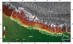
[[File:Nepal topo en.jpg|thumb|The light green areas indicate the Terai in Nepal]] | |||
The [[Inner Terai Valleys of Nepal]] consists of five elongated valleys located between the [[lower Himalayan Range]] and [[Sivalik Hills]].<ref name=Nagendra2002>{{cite journal |author=Nagendra, H. |year=2002 |title=Tenure and forest conditions: community forestry in the Nepal Terai |journal=Environmental Conservation |volume=29 |issue=4 |pages=530–539 |doi=10.1017/S0376892902000383 |bibcode=2002EnvCo..29..530N |s2cid=86632135 |url=https://www.researchgate.net/publication/230559256}}</ref> From north-west to south-east these valleys are: | |||
* [[Surkhet Valley]] in the [[Surkhet district]], north of the [[Kailali District|Kailali]] and [[Bardiya District]]s;<ref name=Guneratne02/> | |||
* [[Dang Valley]] in the [[Dang Deokhuri district]];<ref name=Guneratne02/> | |||
* [[Deukhuri Valley]] located south of the Dang Valley;<ref name=Guneratne02/> | |||
* [[Chitwan Valley]] stretching across the [[Chitwan District|Chitwan]] and [[Makwanpur District]]s;<ref name=Guneratne02/> | |||
* [[Kamala Valley]], also called Udayapur Valley, in the [[Udayapur District]] north of the [[Siraha District|Siraha]] and [[Saptari District]]s.<ref name=Guneratne02/><ref>{{cite thesis |author=Rai, C. B. |year=2010 |title=Analysis of timber production and institutional barriers: A case of community forestry in the Terai and Inner Terai regions of Nepal |type=PhD thesis |publisher=Lincoln University |location=Christchurch}}</ref> | |||
=== Outer Terai === | |||
The Outer Terai begins south of the Sivalik Hills and extends to the [[Indo-Gangetic Plain]]. In the [[Far-Western Region, Nepal]], it comprises the [[Kanchanpur District|Kanchanpur]] and Kailali Districts; in the [[Mid-Western Region, Nepal]], Bardiya and [[Banke District]]s. Further east, the Outer Terai comprises the [[Kapilvastu District|Kapilvastu]], [[Rupandehi District|Rupandehi]], [[Nawalparasi District|Nawalparasi]], [[Parsa District|Parsa]], [[Bara District|Bara]], [[Rautahat District|Rautahat]], [[Sarlahi District|Sarlahi]], [[Mahottari District|Mahottari]], [[Dhanusa District|Dhanusa]], Siraha, Saptari, [[Sunsari District|Sunsari]], [[Morang District|Morang]] and [[Jhapa District]]s.<ref name=Guneratne02/> | |||
=== Protected areas === | |||
Several protected areas were established in the Terai since the late 1950s: | |||
*[[Pilibhit Tiger Reserve]]<ref name="Pilibhit Tiger Reserve">{{cite web|url=https://dfe.gov.in/uploads/documents/pilibhit_tiger_reserve_coimbatore.pdf|title=field experience of Pilibhit tiger reserve}}</ref> | |||
*Sonaripur Wildlife Sanctuary, now [[Dudhwa National Park]] in 1958<ref name=Mathur2008>Mathur, P. K. and N. Midha (2008). [http://moef.nic.in/downloads/public-information/Volume_IV_NPWS.pdf ''Mapping of National Parks and Wildlife Sanctuaries, Dudhwa Tiger Reserve'']. WII – NNRMS - MoEF Project, Final Technical Report. Wildlife Institute of India, Dehradun.</ref> | |||
*[[Kishanpur Wildlife Sanctuary]] in 1972<ref name=Seidensticker2010>{{cite book |author1=Seidensticker, J. |author2=Dinerstein, E. |author3=Goyal, S.P. |author4=Gurung, B. |author5=Harihar, A. |author6=Johnsingh, A.J.T. |author7=Manandhar, A. |author8=McDougal, C.W. |author9=Pandav, B. |author10=Shrestha, M. |author11=Smith, J.D. |year=2010 |chapter=Tiger range collapse and recovery at the base of the Himalayas |title=Biology and Conservation of Wild Felids |editor1=Macdonald, D. W. |editor2=Loveridge, A. J. |pages=305–324 |publisher=Oxford University Press |location=Oxford}}</ref> | |||
*[[Chitwan National Park]] in 1973<ref name=nbrb07/> | |||
*[[Katarniaghat Wildlife Sanctuary]] in 1975<ref name=Mathur2008/> | |||
*[[Shuklaphanta Wildlife Reserve]] in 1976<ref name=nbrb07/> | |||
*[[Koshi Tappu Wildlife Reserve]] in 1976<ref name=nbrb07/> | |||
*[[Udaypur Wildlife Sanctuary]] in 1978<ref>Negi, S. S. (2002). [https://books.google.com/books?id=JYFmoOWfmX8C&pg=PP1 Handbook of National Parks, Sanctuaries, and Biosphere Reserves in India]. New Delhi: Indus Publishing.</ref> | |||
*[[Rajaji National Park]] in 1983<ref name=Seidensticker2010/> | |||
*[[Parsa National Park]] in 1984<ref name=nbrb07/> | |||
*[[Bardia National Park]] in 1988<ref name=nbrb07/> | |||
*[[Valmiki National Park]] in 1989<ref>{{cite journal |author1=Smith J.L.D. |author2=Ahern S.C. |author3=McDougal C. |year=1998 |title=Landscape analysis of tiger distribution and habitat quality in Nepal |journal=Conservation Biology |volume=12 |issue=6 |pages=1338–1346 |doi=10.1046/j.1523-1739.1998.97068.x}}</ref> | |||
*Jhilmil Jheel Conservation Reserve in 2005<ref name=Tewari2013/> | |||
*[[Banke National Park]] in 2010<ref>DNPWC (2010). [http://www.dnpwc.gov.np/protected-areas/national-parks/item/56-banke-national-park ''Banke National Park''] {{webarchive|url=https://web.archive.org/web/20120215150923/http://www.dnpwc.gov.np/protected-areas/national-parks/item/56-banke-national-park |date=2012}} Government of Nepal, Ministry of Forests and Soil Conservation, Department of National Parks and Soil Conservation</ref> | |||
*[[Sohagi Barwa Wildlife Sanctuary]] {{cn|date=August 2025}} | |||
== Climate == | |||
Based on the [[Köppen–Geiger climate classification system]], the Nepal Terai experiences a dry-winter [[humid subtropical climate]] (''Cwa'') with pleasant to warm winters and sweltering summers, a mean annual temperature of {{convert|20-28|C}}, and a mean annual rainfall of {{convert|1600-1800|mm|abbr=on}} in the west and {{convert|2500-3000|mm|abbr=on}} in the east.<ref>{{cite journal |last1=Karki |first1=R. |last2=Talchabhadel |first2=R. |last3=Aalto |first3=J. |last4=Baidya |first4=S. K. |year=2016 |title=New climatic classification of Nepal |journal=Theoretical and Applied Climatology |volume=125 |issue=3–4 |pages=799–808 |doi=10.1007/s00704-015-1549-0 |bibcode=2016ThApC.125..799K |s2cid=117554807 |url=https://www.researchgate.net/publication/280034906}}</ref> | |||
{{climate chart | |||
|[[Biratnagar]], 26°N, 87°E | |||
|9|23|9 | |||
|11|26|13 | |||
|14|32|19 | |||
|20|34|53 | |||
|23|33|170 | |||
|25|33|341 | |||
|26|32|559 | |||
|26|33|359 | |||
|24|32|311 | |||
|22|31|89 | |||
|14|28|12 | |||
|10|25|6 | |||
|source=[http://www.levoyageur.net/weather-city-BIRATNAGAR-AIRPORT.html Levoyageur] | |||
|float=right | |||
|clear=left | |||
}} | |||
{{climate chart | |||
|[[Chandigarh]], 30°N, 77°E | |||
|7.2|18.2|37.8 | |||
|10.4|22.6|37.3 | |||
|14.7|28.0|27.4 | |||
|20.3|34.6|17.5 | |||
|24.7|38.6|26.8 | |||
|26.7|37.7|146.7 | |||
|26.9|34.1|275.6 | |||
|26.2|33.2|273 | |||
|24.4|32.9|154.6 | |||
|18.4|32.0|14.2 | |||
|12.3|27.0|5.2 | |||
|8.0|22.1|22.3 | |||
|source=[https://cdsp.imdpune.gov.in/extremes_1991_2020/?stn=42105# India Metereological Department] | |||
|float=right | |||
|clear=left | |||
}} | |||
{{clear}} | |||
== Ethnic groups == | |||
[[File:Tharu Mahila.jpg|thumb|Tharu people of Terai]] | |||
[[Tharu people|Tharu]] and [[Dhimal]] people are the [[Indigenous peoples|indigenous]] inhabitants of the Terai.<ref name=Rai2014>{{cite journal |author=Rai, J. |year=2014 |title=Malaria, Tarai Adivasi and the Landlord State in the 19th century Nepal: A Historical-Ethnographic Analysis |journal=Dhaulagiri Journal of Sociology and Anthropology |volume=7 |issue=7 |pages=87–112 |doi=10.3126/dsaj.v7i0.10438 |doi-access=free}}</ref> Several Tharu subgroups are scattered over most of the Nepal and Indian Terai.<ref name=Kumar2012/><ref>{{cite journal |author=Krauskopff, G. |year=1995 |title=The Anthropology of the Tharus: An Annoted Bibliography |journal=Kailash |volume=17 |issue=3/4 |pages=185–213}}</ref><ref>{{cite journal |author1=Sharma, J. |author2=Gairola, S. |author3=Gaur, R.D. |author4=Painuli, R.M. |year=2011 |title=Medicinal plants used for primary healthcare by Tharu tribe of Udham Singh Nagar, Uttarakhand, India |journal=International Journal of Medicinal and Aromatic Plants 1 |issue=3 |pages=228–233}}</ref> They used to be semi-nomadic, practised [[shifting cultivation]] and collected wild fruits, vegetables and [[medicinal herbs]].<ref name=mclean99>{{cite journal |author=McLean, J. |year=1999 |title=Conservation and the impact of relocation on the Tharus of Chitwan, Nepal |journal=Himalayan Research Bulletin |volume=XIX |issue=2 |pages=38–44 |url=http://digitalcommons.macalester.edu/cgi/viewcontent.cgi?article=1628&context=himalaya}}</ref> They have been living in the Terai for many centuries and reputedly had an innate resistance to [[malaria]].<ref name="terrenato88">{{Cite journal |author1=Terrenato, L. |author2=Shrestha, S. |author3=Dixit, K. A. |author4=Luzzatto, L. |author5=Modiano, G. |author6=Morpurgo, G. |author7=Arese, P. |title=Decreased malaria morbidity in the Tharu people compared to sympatric populations in Nepal |journal=Annals of Tropical Medicine and Parasitology |volume=82 |issue=1 |year=1988 |pages=1–11 |pmid=3041928 |doi=10.1080/00034983.1988.11812202}}</ref> | |||
Dhimal reside in the eastern Nepal Terai, viz Sunsari, Morang and Jhapa Districts. In the past, they lived in the fringes of the forest and conducted a semi-nomadic life to evade outbreaks of diseases. Today, they are subsistence farmers.<ref name=Rai2014/> | |||
The [[Bhoksa people]] are indigenous to the western Terai in the Indian [[Kumaon division]].<ref name=Ranjan2010/> | |||
[[Maithils]] inhabit the Indian Terai in Bihar and the eastern Terai in Nepal. [[Bhojpuri people]] reside in the central and eastern Terai, and [[Awadhi people]] live in the central and western Terai. [[Bantawa]] people reside foremost in two districts of the eastern Terai in Nepal.<ref name=e16>Lewis, M. P. (ed.) (2009). [http://archive.ethnologue.com/16/show_language.asp?code=mai Maithili] {{Webarchive|url=https://web.archive.org/web/20130922005007/http://archive.ethnologue.com/16/show_language.asp?code=mai |date=22 September 2013 }} [https://www.ethnologue.com/language/bho Bhojpuri] [https://www.ethnologue.com/language/awa Awadhi] [http://archive.ethnologue.com/16/show_language.asp?code=bap Bantawa]. Ethnologue: Languages of the World. Sixteenth edition. Dallas, Texas: SIL International.</ref> | |||
Following the malaria eradication program using [[DDT]] in the 1960s, a large and heterogeneous non-Tharu population settled in the Nepal Terai.<ref name="terrenato88"/> | |||
[[Pahari people (Nepal)|Pahari people]] from the mid-hills including [[Bahun]], [[Chhetri]] and [[Newar]] moved to the plains in search of arable land. In the rural parts of the Nepal Terai, distribution and value of land determine economic hierarchy to a large extent. High [[Ethnicity and caste in Nepal|caste]] migrants from the hills and traditional Tharu landlords who own agriculturally productive land constitute the upper level of the economic hierarchy. The poor are the landless or near landless Terai [[Dalit]]s, including the [[Musahar]], [[Chamar]] and [[Mallaah]].<ref>{{cite book |author=Hatlebakk, M. |year=2007 |title=Economic and social structures that may explain the recent conflicts in the Terai of Nepal |publisher=Chr. Michelsens Institute |location=Bergen}}</ref> Several [[Chepang people]] also live in Nepal's central and eastern Terai districts.<ref>{{cite book |author=Gurung, G. |year=1989 |title=The Chepangs: A Study in Continuity and Change |url=https://books.google.com/books?id=RmBuAAAAMAAJ&q=chepang+migrated+into+terai |location=Kathmandu |publisher=S. B. Shahi |pages=125}}</ref><ref>Lewis, M. P. (ed.) (2009). [http://archive.ethnologue.com/16/show_language.asp?code=cdm Chepang]. Ethnologue: Languages of the World. Sixteenth edition. Dallas, Texas: SIL International.</ref> | |||
As of June 2011, the human population in the Nepal Terai totalled 13,318,705 people in 2,527,558 households comprising more than 120 different ethnic groups and [[Caste system in Nepal|caste]]s such as [[Badi people|Badi]], [[Chamling people|Chamling]], [[Ghale]], [[Kumal people|Kumal]], [[Limbu people|Limbu]], [[Magar people|Magar]], [[Muslim]], [[Rajbongshi people|Rajbanshi]], [[Teli]], [[Thakuri]], [[Yadav]] and [[Majhi language|Majhi]] speaking people.<ref name="Census2011">{{cite book |author=Central Bureau of Statistics |year=2012 |title=National Population and Housing Census 2011 |url=https://unstats.un.org/unsd/demographic/sources/census/wphc/Nepal/Nepal-Census-2011-Vol1.pdf |publisher=Government of Nepal |location=Kathmandu}}</ref> | |||
== History == | |||
[[File:Nainital, Uttarakhand, India - panoramio - Vipin Vasudeva (7).jpg|thumb|Jungle in Uttarakhand]] | |||
The [[Muslim invasions of India|Muslim invasion]] of northern India during the 14th century forced Hindu and Buddhist people to seek refuge from religious persecution. [[Rajput]] nobles and their entourage migrated to the Himalayan foothills and gained control over the region from [[Kashmir]] to the eastern Terai during the following three centuries.<ref>{{cite journal |author=English, R. |year=1985 |title=Himalayan state formation and the impact of British rule in the nineteenth century |journal=Mountain Research and Development |volume=5 |issue=1 |pages=61–78 |doi=10.2307/3673223|jstor=3673223}}</ref> | |||
By the 16th century, the rulers of [[Palpa District|Palpa]] and [[Makwanpur District|Makwanpur]] controlled the mid-western Terai and extended this control to the eastern Terai by the 17th century.{{sfn|Gaige|1975|p=59–60}} They controlled the area of today's districts of [[Saptari District|Saptari]], Siraha, [[Dhanusa District|Dhanusa]], Mahottari and Sarlahi.{{sfn|Pradhan|2012|p=4}} The rulers of Makwanpur controlled the central Terai region of present-day Nepal, and the rulers of Vijayapur controlled today's Sunsari, Morang and Jhapa Districts.{{sfn|Pradhan|2012|p=4–5}} The [[Shah dynasty]] conquered the eastern Nepal Terai in the 1770s.{{sfn|Gaige|1975|p=60}} They also conquered land in the eastern Terai that belonged to the [[Kingdom of Sikkim]].<ref>{{cite book |author=Bagchi, R. |year=2012 |title=Gorkhaland: Crisis of Statehood |publisher=Sage Publications |location=New Delhi |isbn=9788132116806 |url=https://books.google.com/books?id=xbGICwAAQBAJ&pg=PP1}}</ref> | |||
The [[Tulsipur State]], in the Dang Valley of Nepal's western Terai, was also an independent kingdom until it was conquered in 1785 by [[Bahadur Shah of Nepal]] during the [[unification of Nepal]].<ref>{{cite journal |author=Bouillier, V. |year=1993 |title=The Nepalese state and Gorakhnati yogis: the case of the former kingdoms of Dang Valley: 18–19th centuries |journal=Contributions to Nepalese Studies |volume=20 |issue=1 |pages=29–52}}</ref> Until the mid 18th century, the Nepal Terai was divided into several smaller kingdoms, and the forests and wild places were, largely, left undisturbed.<ref name=Gautam2004>{{cite journal |author1=Gautam, A. P. |author2=Shivakoti, G. P. & Webb, E. L. |year=2004 |title=A review of forest policies, institutions, and changes in the resource condition in Nepal |journal=International Forestry Review |volume=6 |issue=2 |pages=136–148 |doi=10.1505/ifor.6.2.136.38397 |s2cid=56106310}}</ref> | |||
Since the late 18th century, however, the Shah rulers encouraged Indians to settle in the Terai, and supported famine-stricken Bihari farmers in efforts to convert to a more productive agricultural lifestyle in the eastern Nepal Terai.<ref name=Dahal1983>{{cite journal |author=Dahal, D. R. |year=1983 |title=Economic development through indigenous means: A case of Indian migration in the Nepal Terai |journal=Contribution to Nepalese Studies |volume=11 |issue=1 |pages=1–20 |url=http://himalaya.socanth.cam.ac.uk/collections/journals/contributions/pdf/CNAS_11_01_01.pdf}}</ref> | |||
From at least 1786 onward, they appointed government officers in the eastern Terai districts of Parsa, Bara, Rautahat, Mahottari, Saptari and Morang to levy taxes, collect revenues and maintain civil order, as well as to hunt wild game, including [[Indian elephant]]s and [[Indian rhinoceros]], mostly for their ivory.<ref name=Regmi1972>{{cite journal |author=Regmi, M. C. |author-link=Mahesh Chandra Regmi |year=1972 |title=Notes On The History Of Morang District |journal=Regmi Research Series |volume=4 |issue=1 |pages=1–4, 24–25 |url=http://scholar.googleusercontent.com/scholar?q=cache:jSwmI6bF5UEJ:scholar.google.com/}}</ref><ref name=Regmi1988>{{cite journal |author=Regmi, M. C. |year=1988 |title=Chautariya Dalamardan Shah's venture; Subedar in Eastern and Western Nepal; A special Levy in the Eastern Tarai Region |journal=Regmi Research Series |volume=20 |issue=1/2 |pages=1–180 |url=http://scholar.googleusercontent.com/scholar?q=cache:JDjzcBnfpvwJ:scholar.google.com/}}</ref> At the end of the 18th century, between 200 and 300 elephants were caught annually, using [[Trapping#Snares|snares]] or nooses.{{sfn|Kirkpatrick|1811|p=17–18}} | |||
The far-western and mid-western regions of the Nepal Terai (called '[[Naya Muluk]]', or 'new country') lay on the northern periphery of the [[Awadh]] dynasty. After Nepal lost the [[Anglo–Nepalese War]] of 1816, the [[British rule in India|British]] annexed these regions of the Terai when the [[Sugauli Treaty]] was ratified; as a reward for Nepal's military aid in the [[Indian Rebellion of 1857]], they returned some of this region in 1860, namely today's districts of Kanchanpur, Kailali, Banke and Bardiya.<ref name=Guneratne02>{{Cite book |author=Guneratne, A. |title=Many tongues, one people: the making of Tharu identity in Nepal |place=Ithaca, New York |publisher=Cornell University Press |year=2002 |chapter=The Tharu and the Tarai |pages=20–61 |chapter-url=https://books.google.com/books?id=T7FWQ6dzYZQC&pg=PA20 |isbn=0801487285}}</ref> | |||
To promote economic development of the Nepal Terai, people from the hills were invited to settle in the region. Since only a few moved to the Terai, Indian people were further encouraged to settle.{{sfn|Gaige|1975|p=62}} Immigration of Indian people increased between 1846 and 1950.<ref name=Dahal1983/> They settled in the eastern Nepal Terai, living in close proximity with native Terai peoples.<ref name=Guneratne02/> | |||
The Indian Terai remained largely uninhabited until the end of the 19th century, as it was arduous and dangerous to penetrate the dense [[marsh]]- and [[malaria]]-filled [[jungle]] with its predators.<ref>{{cite book |author=Crooke, W. |year=1897 |title=North-Western Provinces of India |publisher=Methuen & Co. |location=London |url=https://archive.org/stream/northwesternprov00croo/northwesternprov00croo}}</ref> | |||
[[Dacoit]] gangs retreated to the Terai jungles, and the area was considered lawless and wild by the British, who sought control of the region's valuable timber reserves.<ref>{{cite book |editor=Sarkar, S. |year=2000 |title=Issues in modern Indian history: for Sumit Sarkar |publisher=Mumbai: Popular Prakashan |author=Arnold, D. |chapter=Disease, Resistance and India's Ecological Frontier, 1770–1947 |pages=1–22 |isbn=9788171546589 |chapter-url=https://books.google.com/books?id=S2Yn4LlujqsC&pg=PA8}}</ref> The region was densely forested with stands of foremost [[Shorea robusta|Sal]].<ref name="Guneratne02"/> | |||
Heavy logging began in the 1920s. Extracted timber was exported to India to collect revenues. Cleared areas were subsequently used for agriculture.<ref name=Gautam2004/> | |||
But still, the Terai jungles were teeming with wildlife.<ref>{{cite book |author=Champion, F. W. |author-link=Frederick Walter Champion|year=1932 |title=The jungle in sunlight and shadow |publisher=London: Chatto & Windus |url=https://archive.org/details/JungleSunlightShadow}}</ref> | |||
Inner Terai valleys historically were agriculturally productive but extremely malarial. Some parts were left forested by official decree during the [[Rana dynasty]] as a defensive perimeter called ''Char Kose Jhadi'', meaning 'four kos forest'; one kos equals about {{convert|3|km|mi|abbr=on}}. A British observer noted, "Plainsmen and paharis generally die if they sleep in the Terai before November 1 or after June 1." British travelers to Kathmandu went as fast as possible from the border at [[Raxaul]] to reach the hills before nightfall.<ref name=Guneratne02/> | |||
Malaria was eradicated using [[DDT]] in the mid-1950s, at the unfortunate expense of future generations of birds, especially vultures, which were especially sensitive to the chemical. Subsequently, people from the hills migrated to the Terai.<ref name=Regmi1994>{{cite journal |author=Regmi, R. R. |year=1994 |title=Deforestation and Rural Society in the Nepalese Terai |journal=Occasional Papers in Sociology and Anthropology |volume=4 |pages=72–89|doi=10.3126/opsa.v4i0.1086 |doi-access=free }}</ref> | |||
About 16,000 [[Tibetan people|Tibetan]] refugees settled in the Nepal Terai in 1959–1960, followed by refugees of Nepali origin from [[Burma]] in 1964, from [[Nagaland]] and [[Mizoram]] in the late 1960s, and about 10,000 [[Bihar]]i Muslims from Bangladesh in the 1970s.<ref>{{cite journal |author=Subedi, B. P. |year=1991 |title=International migration in Nepal: Towards an analytical framework |journal=Contribution to Nepalese Studies |volume=18 |issue=1 |pages=83–102}}</ref> | |||
Timber export continued until 1969. In 1970, [[King Mahendra]] granted land to loyal ex-army personnel in the districts of Jhapa, Sunsari, Rupandehi and Banke Districts, where seven colonies were developed for resettling about 7,000 people. They acquired property rights over uncultivated forest and 'waste' land, thus accelerating the deforestation process in the Terai.<ref name=Regmi1994/> | |||
Between 1961 and 1991, the annual population growth in the Terai was higher than the national average, which indicates that migration from abroad occurred at a large scale. Deforestation continued, and forest products from state-owned forest were partly smuggled to India. [[Community forestry]] was introduced in 1995.<ref>{{cite journal |author=Chakraborty, R. N. |year=2001 |title=Stability and outcomes of common property institutions in forestry: evidence from the Terai region of Nepal |journal=Ecological Economics |volume=36 |issue=2 |pages=341–353 |doi=10.1016/s0921-8009(00)00237-8 |bibcode=2001EcoEc..36..341C |url=https://www.uni-hohenheim.de/fileadmin/einrichtungen/entwicklungspolitik/05_Teaching/02_Lecture_Material/02_Rural_Development_Policy/02_Land_Tenure/Stability_and_outcomes_of_common_property_institution_in_for.pdf}}</ref> | |||
Since the 1990s, migration from the Terai to urban centres is increasing and causing sociocultural changes in the region.<ref>{{cite journal |author1=Gartaula, H. N. |author2=Niehof, A. |name-list-style=amp |year=2013 |title=Migration to and from the Nepal Terai: shifting movements and motives |journal=The South Asianist |volume=2 |issue=2 |pages=29–51}}</ref> | |||
==Politics== | |||
Since the early 1950s, several political parties advocated for [[autonomy]] and independence of the Nepal Terai, such as the [[Nepal Terai Congress]] and [[Janatantrik Terai Mukti Morcha]].<ref>{{cite book |author=Hangen, S. |year=2007 |title=Creating a "New Nepal": the ethnic dimension |publisher=East-West Center |location=Washington |isbn=9781932728620}}</ref><ref name=Kabir2012>{{Cite book |author=Kabir, H. |year=2012 |title=The rise of new regional political force in Madhes and its consequence in post-conflict Nepal |publisher=Hiroshima University Partnership Project for Peace Building and Capacity Development |series=Discussion Paper Series |volume=15 |location=Hiroshima |url=https://www.researchgate.net/publication/304500459}}</ref> | |||
Several armed groups were formed, which pursued this aim using violent means.<ref name=Miklian2008>{{cite book |author=Miklian, J. |year=2009 |title=Nepal's Terai: Constructing an Ethnic Conflict. South Asia Briefing Paper #1 |location=Oslo |publisher=International Peace Research Institute |isbn=((978-82-7288-309-5)) |url=http://www.ashraya-nepal.com/documents/Nepals_Terai_(South_Asia_Briefing_Paper_1).pdf}}</ref> | |||
In 2013, more than 24 Madheshi political parties were registered for the [[2nd Nepalese Constituent Assembly|Constituent Assembly of Nepal]] election.<ref>{{cite journal |author1=Pandey, K. |year=2017 |title=Politicising ethnicity: Tharu contestation of Madheshi identity in Nepal's Tarai |journal=The South Asianist |volume=5 |issue=1 |pages=304–322 |url=http://www.southasianist.ed.ac.uk/article/download/1632/2499 |archive-date=17 December 2024 |access-date=13 September 2019 |archive-url=https://web.archive.org/web/20241217111249/https://www.southasianist.ed.ac.uk/article/download/1632/2499 |url-status=dead }}</ref> | |||
=== Border disputes === | |||
The most significant border dispute of the Indo-Nepal boundary in the Terai region is the [[Susta territory|Susta]] area. In the Susta region, 14,500 hectares of land is under dispute but recent development has manage to discuss it bilaterally.<ref name="thediplomat">{{cite news |url=https://thediplomat.com/2014/09/india-and-nepal-tackle-border-disputes/ |title=India and Nepal Tackle Border Disputes |author=Groves, S.|date=2014 |newspaper=The Diplomat|access-date=19 March 2018}}</ref><ref>{{cite news |author=Giri, A. |year=2015 |url=https://kathmandupost.ekantipur.com/ampnews/2015-01-06/nepal-aims-to-settle-boundary-dispute-with-india-in-4-years.html |title=Nepal aims to settle boundary dispute with India in 4 years |newspaper=Kathmandu Post}}</ref> | |||
=== Indian influence in Nepal Terai === | |||
After the [[2008 Nepalese Constituent Assembly election]], Indian politicians kept on trying to secure strategic interests in the Nepal Terai, such as over hydropower energy, development projects, business and trade.<ref>Ojha, H. (2015). [https://thediplomat.com/2015/11/the-india-nepal-crisis/ The India-Nepal Crisis]. The Diplomat.</ref> The [[government of Nepal]] has accused India of imposing an undeclared [[2015 Nepal blockade|blockade in 2015]] but it is not clear yet, local peoples blame Nepal administration and government.<ref>{{Cite news |date=2015 |author=Press Trust of India |url=http://www.ndtv.com/india-news/nepal-pm-wants-india-to-lift-undeclared-blockade-1243695 |title=Nepal PM Wants India to Lift Undeclared Blockade|access-date=2016-09-12}}</ref> | |||
===Humanitarian works=== | |||
[[Sitaram Kattel|Dhurmus Suntali Foundation]] handed over an integrated community containing 50 houses to [[Musahar]] community of [[Bardibas]] at a cost of Rs. 63 million.<ref>{{cite web|url=http://kathmandupost.ekantipur.com/news/2017-04-15/dhurmus-suntali-foundation-gifts-homes-to-musahar-community.html|title=Dhurmus Suntali Foundation gifts homes to Musahar community|website=ekantipur.com|access-date=19 March 2018}}</ref> | |||
== Economy == | |||
=== Economy in Nepal Terai === | |||
The Terai is the most productive region in Nepal with the majority of the country's industries. Agriculture is the basis of the economy.<ref>{{Cite book |author=Sharma, R. P. |title=Nepal: A Detailed Geographical Account |place=Kathmandu |publisher=Kathmandu: Pustak Sansar |year=1974}}</ref> Major crops include [[rice]], [[wheat]], [[maize]], [[potato]], [[peas]], [[lentil]], [[Mustard oil|mustard]], [[sugar cane]], [[ginger]], [[turmeric]], [[cardamom]], [[garlic]] and [[Chili pepper|chili]]. Fruits comprise [[mango]], [[lychee]], [[guava]], [[papaya]], [[banana]] and [[jackfruit]].<ref>{{cite book |editor=Papademetriou, M. K. |editor2=Dent, F. J. |year=2001 |title=Crop Diversification in the Asia-Pacific Region |series=RAP publication 81 |publisher=FAO |location=Bangkok |author=Sharma, K.C. |chapter=Crop diversification in Nepal |pages=81–94 |chapter-url=https://coin.fao.org/coin-static/cms/media/9/13171763115260/2001_03_high.pdf#page=88}}</ref> The Terai is also known for [[beekeeping]] and [[honey]] production, with about 120,000 colonies of ''[[Apis cerana]]''.<ref>Thapa, R. (2003). ''[http://www.apimondia.com/apiacta/slovenia/en/thapa.pdf Himalayan Honeybees and Beekeeping in Nepal] {{Webarchive|url=https://web.archive.org/web/20150923172625/http://www.apimondia.com/apiacta/slovenia/en/thapa.pdf |date=23 September 2015 }}''. Standing Commission of Beekeeping for Rural Development. Apimondia Journal.</ref> | |||
In Jhapa District, [[Camellia sinensis|tea]] has been cultivated since 1960; the annual production of 2005 was estimated at 10.1 million kg.<ref>{{cite book |author=Thapa, A.N. |year=2005 |title=Concept Paper on Study of Nepalese Tea Industry-Vision 2020 |publisher=Nepal Tree Crop Global Development Alliance |location=Kathmandu |url=http://www.consulat-nepal.org/IMG/pdf/NATIONAL_NEPALESE_TEA_POLICY__YEAR_2005_VISION_2020_-2.pdf |archive-date=23 August 2017 |access-date=23 April 2017 |archive-url=https://web.archive.org/web/20170823161602/http://www.consulat-nepal.org/IMG/pdf/NATIONAL_NEPALESE_TEA_POLICY__YEAR_2005_VISION_2020_-2.pdf |url-status=dead}}</ref> | |||
=== Economy in Indian Terai === | |||
[[Darjeeling tea|Tea]] cultivation was introduced in the Darjeeling Terai in 1862.<ref name="Ghosh04" /> | |||
== References == | |||
{{Reflist}} | |||
===Bibliography=== | |||
*{{cite book |last=Gaige |first=F. H. |year=1975 |title=Regionalism and National Unity in Nepal |publisher=Vikas Publishing House |location=Delhi |edition=Second |chapter=Migration into the Tarai |pages=58–86 |chapter-url=https://archive.org/stream/in.ernet.dli.2015.110490/2015.110490.Regionalism-And-National-Unity-In-Nepal#page/n65/mode/2up }} | |||
*{{cite book |last=Kirkpatrick |first=W. |author-link=William Kirkpatrick (East India Company officer) |year=1811 |title=An Account of the Kingdom of Nepaul, Being the Substance of Observations Made During a Mission to that Country, in the Year 1793 |location=London |publisher=William Miller |chapter=Chapter I. |pages=11–25 |chapter-url=https://archive.org/details/bub_gb_ijxAAAAAYAAJ/page/n25 }} | |||
*{{cite book |last=Pradhan |first=K. L. |title=Thapa Politics in Nepal: With Special Reference to Bhim Sen Thapa, 1806–1839 |publisher=Concept Publishing Company |year=2012 |isbn=9788180698132 |location=New Delhi |chapter=Introduction |pages=1–19 |chapter-url=https://books.google.com/books?id=7PP1yElRzIUC&pg=PA1 }} | |||
== External links == | |||
{{Wikivoyage|Tarai}} | |||
* [http://assets.panda.org/img/original/ecology_map.jpg WWF: ''Map of ecological divisions of Nepal'', showing the Terai] | |||
*[http://www.statoids.com/unp.html Terai districts of Nepal in the past] | |||
{{Authority control}} | |||
{{West Bengal}} | |||
{{Uttarakhand}} | |||
[[Category:Regions of Nepal]] | |||
[[Category:Regions of India]] | |||
[[Category:Plains of Nepal]] | |||
[[Category:Plains of India]] | |||
[[Category:Grasslands of India]] | |||
[[Category:Grasslands of Nepal]] | |||
[[Category:Grasslands of Bhutan]] | |||
[[Category:Geography of Uttarakhand]] | |||
[[Category:Landforms of Uttarakhand]] | |||
[[Category:Wetlands of Nepal]] | |||
[[Category:Ganges basin]] | |||
[[Category:Ecoregions of the Himalayas]] | |||
[[Category:Indomalayan ecoregions]] | |||
Latest revision as of 01:22, 25 March 2026
| Terai | |
|---|---|
 Aerial view of Terai plains near Biratnagar, Nepal | |
| Ecology | |
| Realm | Indomalayan realm |
| Animals | gharial, mugger crocodile, king cobra |
| Bird species | Bengal florican, lesser adjutant, swamp francolin, white-rumped vulture, Oriental darter, sarus crane |
| Mammal species | Indian rhinoceros, Asian elephant, gaur, blackbuck, tiger, leopard, jungle cat, fishing cat, leopard cat, smooth-coated otter, large Indian civet, Asian palm civet, small Indian civet, hispid hare |
| Geography | |
| Countries | Nepal, India |
| Elevation | 67–300 m (220–984 ft) |
| Rivers | Sharda River, Karnali River, Gandaki River, Koshi River |
Climate type | tropical savanna climate |
Soil types | alluvial |
| Conservation | |
| Global 200 | Terai-Duar savanna and grasslands |
The Terai or Tarai is a lowland region in parts of southern Nepal and northern India that lies to the south of the outer foothills of the Himalayas, the Sivalik Hills and north of the Indo-Gangetic Plain. This region is characterised by tall grasslands, scrub savannah, sal forests and clay rich swamps. In North India, the Terai spreads from the Yamuna River eastward across Haryana, Uttarakhand, Uttar Pradesh, Bihar and West Bengal. The Terai is part of the Terai-Duar savanna and grasslands ecoregion.[1] Nepal's Terai stretches over 33,998.8 km2 (13,127.0 sq mi), about 23.1% of Nepal's land area, and lies at an elevation of between 67 and 300 m (220 and 984 ft). The region comprises more than 50 wetlands. North of the Terai rises the Bhabar, a narrow but continuous belt of forest about 8–12 km (5.0–7.5 mi) wide.[2]
Etymology[edit | edit source]
The Urdu word ترائی tarāʼī means "lands lying at the foot of a watershed" or "on the banks of a river; low ground flooded with water, valley, basin, marshy ground, marsh, swamp; meadow".[3] In Hindi, the region is called तराई 'tarāī' meaning "foot-hill".[4] In Nepali, the region is called तराइ 'tarāi' meaning "the low-lying land, plain" and especially "the low-lying land at the foot of the Himālayas".[5][6] It has been described as "low, marshy ground".[7]
Geology[edit | edit source]
The Terai is crossed by the large perennial Himalayan rivers Yamuna, Ganges, Sarda, Karnali, Narayani and Kosi that have each built alluvial fans covering thousands of square kilometres below their exits from the hills. Medium rivers such as the Rapti rise in the Mahabharat Range. The geological structure of the region consists of old and new alluvium, both of which constitute alluvial deposits of mainly sand, clay, silt, gravels and coarse fragments. The new alluvium is renewed every year by fresh deposits brought down by active streams, which engage themselves in fluvial action. Old alluvium is found rather away from river courses, especially on uplands of the plain where silting is a rare phenomenon.[8]
A large number of small and usually seasonal rivers flow through the Terai, most of which originate in the Sivalik Hills. The soil in the Terai is alluvial and fine to medium textured. Forest cover in the Terai and hill areas has decreased at an annual rate of 1.3% between 1978 and 1979, and 2.3% between 1990 and 1991.[2] With deforestation and cultivation increasing, a permeable mixture of gravel, boulders and sand evolves, which leads to a sinking water table. But where layers consist of clay and fine sediments, the groundwater rises to the surface and heavy sediment is washed out, thus enabling frequent and massive floods during monsoon, such as the 2008 Bihar flood.[9]
Geography[edit | edit source]
In India, the Terai extends over the states of Haryana, Uttarakhand, Uttar Pradesh, Bihar and West Bengal. These are mostly the districts of these states that are on the India–Nepal border:[1]
- Haryana: Panchkula district
- Uttarakhand: Haridwar district,[10] Udham Singh Nagar district, Champawat district, and Nainital district[11]
- Uttar Pradesh: Pilibhit district, Lakhimpur Kheri district, Bahraich district, Shravasti district, Balrampur district, Gorakhpur district, Kushinagar district, Siddharthnagar district and Maharajganj district[12]
- Bihar: West Champaran district, East Champaran district, Sitamarhi district, Madhubani district, Supaul district, Araria district, Kishanganj district[citation needed]
- West Bengal: Siliguri subdivision of Darjeeling district,[13] Jalpaiguri Sadar subdivision of Jalpaiguri district[citation needed]
Inner Terai[edit | edit source]

The Inner Terai Valleys of Nepal consists of five elongated valleys located between the lower Himalayan Range and Sivalik Hills.[14] From north-west to south-east these valleys are:
- Surkhet Valley in the Surkhet district, north of the Kailali and Bardiya Districts;[15]
- Dang Valley in the Dang Deokhuri district;[15]
- Deukhuri Valley located south of the Dang Valley;[15]
- Chitwan Valley stretching across the Chitwan and Makwanpur Districts;[15]
- Kamala Valley, also called Udayapur Valley, in the Udayapur District north of the Siraha and Saptari Districts.[15][16]
Outer Terai[edit | edit source]
The Outer Terai begins south of the Sivalik Hills and extends to the Indo-Gangetic Plain. In the Far-Western Region, Nepal, it comprises the Kanchanpur and Kailali Districts; in the Mid-Western Region, Nepal, Bardiya and Banke Districts. Further east, the Outer Terai comprises the Kapilvastu, Rupandehi, Nawalparasi, Parsa, Bara, Rautahat, Sarlahi, Mahottari, Dhanusa, Siraha, Saptari, Sunsari, Morang and Jhapa Districts.[15]
Protected areas[edit | edit source]
Several protected areas were established in the Terai since the late 1950s:
- Pilibhit Tiger Reserve[17]
- Sonaripur Wildlife Sanctuary, now Dudhwa National Park in 1958[18]
- Kishanpur Wildlife Sanctuary in 1972[19]
- Chitwan National Park in 1973[2]
- Katarniaghat Wildlife Sanctuary in 1975[18]
- Shuklaphanta Wildlife Reserve in 1976[2]
- Koshi Tappu Wildlife Reserve in 1976[2]
- Udaypur Wildlife Sanctuary in 1978[20]
- Rajaji National Park in 1983[19]
- Parsa National Park in 1984[2]
- Bardia National Park in 1988[2]
- Valmiki National Park in 1989[21]
- Jhilmil Jheel Conservation Reserve in 2005[10]
- Banke National Park in 2010[22]
- Sohagi Barwa Wildlife Sanctuary [citation needed]
Climate[edit | edit source]
Based on the Köppen–Geiger climate classification system, the Nepal Terai experiences a dry-winter humid subtropical climate (Cwa) with pleasant to warm winters and sweltering summers, a mean annual temperature of 20–28 °C (68–82 °F), and a mean annual rainfall of 1,600–1,800 mm (63–71 in) in the west and 2,500–3,000 mm (98–118 in) in the east.[23]
| Biratnagar, 26°N, 87°E | ||||||||||||||||||||||||||||||||||||||||||||||||||||||||||||
|---|---|---|---|---|---|---|---|---|---|---|---|---|---|---|---|---|---|---|---|---|---|---|---|---|---|---|---|---|---|---|---|---|---|---|---|---|---|---|---|---|---|---|---|---|---|---|---|---|---|---|---|---|---|---|---|---|---|---|---|---|
| Climate chart (explanation) | ||||||||||||||||||||||||||||||||||||||||||||||||||||||||||||
| ||||||||||||||||||||||||||||||||||||||||||||||||||||||||||||
| ||||||||||||||||||||||||||||||||||||||||||||||||||||||||||||
| Chandigarh, 30°N, 77°E | ||||||||||||||||||||||||||||||||||||||||||||||||||||||||||||
|---|---|---|---|---|---|---|---|---|---|---|---|---|---|---|---|---|---|---|---|---|---|---|---|---|---|---|---|---|---|---|---|---|---|---|---|---|---|---|---|---|---|---|---|---|---|---|---|---|---|---|---|---|---|---|---|---|---|---|---|---|
| Climate chart (explanation) | ||||||||||||||||||||||||||||||||||||||||||||||||||||||||||||
| ||||||||||||||||||||||||||||||||||||||||||||||||||||||||||||
| ||||||||||||||||||||||||||||||||||||||||||||||||||||||||||||
Ethnic groups[edit | edit source]

Tharu and Dhimal people are the indigenous inhabitants of the Terai.[24] Several Tharu subgroups are scattered over most of the Nepal and Indian Terai.[12][25][26] They used to be semi-nomadic, practised shifting cultivation and collected wild fruits, vegetables and medicinal herbs.[27] They have been living in the Terai for many centuries and reputedly had an innate resistance to malaria.[28] Dhimal reside in the eastern Nepal Terai, viz Sunsari, Morang and Jhapa Districts. In the past, they lived in the fringes of the forest and conducted a semi-nomadic life to evade outbreaks of diseases. Today, they are subsistence farmers.[24]
The Bhoksa people are indigenous to the western Terai in the Indian Kumaon division.[11]
Maithils inhabit the Indian Terai in Bihar and the eastern Terai in Nepal. Bhojpuri people reside in the central and eastern Terai, and Awadhi people live in the central and western Terai. Bantawa people reside foremost in two districts of the eastern Terai in Nepal.[29]
Following the malaria eradication program using DDT in the 1960s, a large and heterogeneous non-Tharu population settled in the Nepal Terai.[28] Pahari people from the mid-hills including Bahun, Chhetri and Newar moved to the plains in search of arable land. In the rural parts of the Nepal Terai, distribution and value of land determine economic hierarchy to a large extent. High caste migrants from the hills and traditional Tharu landlords who own agriculturally productive land constitute the upper level of the economic hierarchy. The poor are the landless or near landless Terai Dalits, including the Musahar, Chamar and Mallaah.[30] Several Chepang people also live in Nepal's central and eastern Terai districts.[31][32] As of June 2011, the human population in the Nepal Terai totalled 13,318,705 people in 2,527,558 households comprising more than 120 different ethnic groups and castes such as Badi, Chamling, Ghale, Kumal, Limbu, Magar, Muslim, Rajbanshi, Teli, Thakuri, Yadav and Majhi speaking people.[33]
History[edit | edit source]
.jpg)
The Muslim invasion of northern India during the 14th century forced Hindu and Buddhist people to seek refuge from religious persecution. Rajput nobles and their entourage migrated to the Himalayan foothills and gained control over the region from Kashmir to the eastern Terai during the following three centuries.[34]
By the 16th century, the rulers of Palpa and Makwanpur controlled the mid-western Terai and extended this control to the eastern Terai by the 17th century.[35] They controlled the area of today's districts of Saptari, Siraha, Dhanusa, Mahottari and Sarlahi.[36] The rulers of Makwanpur controlled the central Terai region of present-day Nepal, and the rulers of Vijayapur controlled today's Sunsari, Morang and Jhapa Districts.[37] The Shah dynasty conquered the eastern Nepal Terai in the 1770s.[38] They also conquered land in the eastern Terai that belonged to the Kingdom of Sikkim.[39] The Tulsipur State, in the Dang Valley of Nepal's western Terai, was also an independent kingdom until it was conquered in 1785 by Bahadur Shah of Nepal during the unification of Nepal.[40] Until the mid 18th century, the Nepal Terai was divided into several smaller kingdoms, and the forests and wild places were, largely, left undisturbed.[41] Since the late 18th century, however, the Shah rulers encouraged Indians to settle in the Terai, and supported famine-stricken Bihari farmers in efforts to convert to a more productive agricultural lifestyle in the eastern Nepal Terai.[42] From at least 1786 onward, they appointed government officers in the eastern Terai districts of Parsa, Bara, Rautahat, Mahottari, Saptari and Morang to levy taxes, collect revenues and maintain civil order, as well as to hunt wild game, including Indian elephants and Indian rhinoceros, mostly for their ivory.[43][44] At the end of the 18th century, between 200 and 300 elephants were caught annually, using snares or nooses.[45]
The far-western and mid-western regions of the Nepal Terai (called 'Naya Muluk', or 'new country') lay on the northern periphery of the Awadh dynasty. After Nepal lost the Anglo–Nepalese War of 1816, the British annexed these regions of the Terai when the Sugauli Treaty was ratified; as a reward for Nepal's military aid in the Indian Rebellion of 1857, they returned some of this region in 1860, namely today's districts of Kanchanpur, Kailali, Banke and Bardiya.[15] To promote economic development of the Nepal Terai, people from the hills were invited to settle in the region. Since only a few moved to the Terai, Indian people were further encouraged to settle.[46] Immigration of Indian people increased between 1846 and 1950.[42] They settled in the eastern Nepal Terai, living in close proximity with native Terai peoples.[15]
The Indian Terai remained largely uninhabited until the end of the 19th century, as it was arduous and dangerous to penetrate the dense marsh- and malaria-filled jungle with its predators.[47] Dacoit gangs retreated to the Terai jungles, and the area was considered lawless and wild by the British, who sought control of the region's valuable timber reserves.[48] The region was densely forested with stands of foremost Sal.[15]
Heavy logging began in the 1920s. Extracted timber was exported to India to collect revenues. Cleared areas were subsequently used for agriculture.[41] But still, the Terai jungles were teeming with wildlife.[49]
Inner Terai valleys historically were agriculturally productive but extremely malarial. Some parts were left forested by official decree during the Rana dynasty as a defensive perimeter called Char Kose Jhadi, meaning 'four kos forest'; one kos equals about 3 km (1.9 mi). A British observer noted, "Plainsmen and paharis generally die if they sleep in the Terai before November 1 or after June 1." British travelers to Kathmandu went as fast as possible from the border at Raxaul to reach the hills before nightfall.[15]
Malaria was eradicated using DDT in the mid-1950s, at the unfortunate expense of future generations of birds, especially vultures, which were especially sensitive to the chemical. Subsequently, people from the hills migrated to the Terai.[50] About 16,000 Tibetan refugees settled in the Nepal Terai in 1959–1960, followed by refugees of Nepali origin from Burma in 1964, from Nagaland and Mizoram in the late 1960s, and about 10,000 Bihari Muslims from Bangladesh in the 1970s.[51] Timber export continued until 1969. In 1970, King Mahendra granted land to loyal ex-army personnel in the districts of Jhapa, Sunsari, Rupandehi and Banke Districts, where seven colonies were developed for resettling about 7,000 people. They acquired property rights over uncultivated forest and 'waste' land, thus accelerating the deforestation process in the Terai.[50] Between 1961 and 1991, the annual population growth in the Terai was higher than the national average, which indicates that migration from abroad occurred at a large scale. Deforestation continued, and forest products from state-owned forest were partly smuggled to India. Community forestry was introduced in 1995.[52] Since the 1990s, migration from the Terai to urban centres is increasing and causing sociocultural changes in the region.[53]
Politics[edit | edit source]
Since the early 1950s, several political parties advocated for autonomy and independence of the Nepal Terai, such as the Nepal Terai Congress and Janatantrik Terai Mukti Morcha.[54][55] Several armed groups were formed, which pursued this aim using violent means.[56] In 2013, more than 24 Madheshi political parties were registered for the Constituent Assembly of Nepal election.[57]
Border disputes[edit | edit source]
The most significant border dispute of the Indo-Nepal boundary in the Terai region is the Susta area. In the Susta region, 14,500 hectares of land is under dispute but recent development has manage to discuss it bilaterally.[58][59]
Indian influence in Nepal Terai[edit | edit source]
After the 2008 Nepalese Constituent Assembly election, Indian politicians kept on trying to secure strategic interests in the Nepal Terai, such as over hydropower energy, development projects, business and trade.[60] The government of Nepal has accused India of imposing an undeclared blockade in 2015 but it is not clear yet, local peoples blame Nepal administration and government.[61]
Humanitarian works[edit | edit source]
Dhurmus Suntali Foundation handed over an integrated community containing 50 houses to Musahar community of Bardibas at a cost of Rs. 63 million.[62]
Economy[edit | edit source]
Economy in Nepal Terai[edit | edit source]
The Terai is the most productive region in Nepal with the majority of the country's industries. Agriculture is the basis of the economy.[63] Major crops include rice, wheat, maize, potato, peas, lentil, mustard, sugar cane, ginger, turmeric, cardamom, garlic and chili. Fruits comprise mango, lychee, guava, papaya, banana and jackfruit.[64] The Terai is also known for beekeeping and honey production, with about 120,000 colonies of Apis cerana.[65]
In Jhapa District, tea has been cultivated since 1960; the annual production of 2005 was estimated at 10.1 million kg.[66]
Economy in Indian Terai[edit | edit source]
Tea cultivation was introduced in the Darjeeling Terai in 1862.[13]
References[edit | edit source]
- ↑ 1.0 1.1 Johnsingh, A. J. T.; Ramesh, K.; Qureshi, Q.; David, A.; Goyal, S. P.; Rawat, G. S.; Rajapandian, K. & Prasad, S. (2004). Conservation status of tiger and associated species in the Terai Arc Landscape, India. RR-04/001 (Report). Dehradun: Wildlife Institute of India. Archived from the original on 13 April 2020. Retrieved 31 December 2017.
- ↑ 2.0 2.1 2.2 2.3 2.4 2.5 2.6 Bhuju, U. R.; Shakya, P. R.; Basnet, T. B. & Shrestha, S. (2007). Nepal Biodiversity Resource Book. Protected Areas, Ramsar Sites, and World Heritage Sites (PDF). Kathmandu: International Centre for Integrated Mountain Development; Government of Nepal, Ministry of Environment, Science and Technology; United Nations Environment Programme, Regional Office for Asia and the Pacific.
- ↑ Platts, J. T. (1884). "ترائي तराई tarāʼī". A dictionary of Urdu, classical Hindi, and English. London: W. H. Allen & Co. p. 316.[permanent dead link]
- ↑ Bahri, H. (1989). "tarāī तराई". Learners' Sanskrit-English dictionary — Siksarthi Hindi-Angrejhi sabdakosa. Delhi: Rajapala. p. 280.[permanent dead link]
- ↑ Turner, R. L. (1931). "तराइ tarāi". A Comparative and Etymological Dictionary of the Nepali Language. London: K. Paul, Trench, Trubner. p. 274.
- ↑ Regmi, M. C. (1963). Land tenure and taxation in Nepal. Vol. 1. Berkeley: Institute of International Studies, University of California. p. 1.
- ↑ Whelpton, J. (2005). "Environment, state and society in the central Himalayas to 1743". A History of Nepal. Cambridge, United Kingdom: Cambridge University Press. pp. 6–34. ISBN 978-0-521-80470-7.
- ↑ Das, K. K. L., Das, K. N. (1981). "Alluvial morphology of the North Bihar Plain – A study in applied geomorphology". In Sharma, H. S. (ed.). Perspectives in Geomorphology. Vol. 3. New Delhi: Naurung Rai Concept Publishing Company. pp. 85–105.
{{cite book}}: CS1 maint: multiple names: authors list (link) - ↑ Bhargava, A. K.; Lybbert, T. J.; Spielman, D. J. (2014). The Public Benefits of Private Technology Adoption (PDF). Selected Paper prepared for presentation at the Agricultural & Applied Economics Association's Annual Meeting, July 2014. Minneapolis, Minnesota.
- ↑ 10.0 10.1 Tewari, R.; Rawat, G.S. (2013). "Studies on the food and feeding habits of Swamp Deer (Rucervus duvaucelii duvaucelii) in Jhilmil Jheel Conservation Reserve, Haridwar, Uttarakhand, India". ISRN Zoology. 2013 (ID 278213): 1–6. doi:10.1155/2013/278213.
- ↑ 11.0 11.1 Ranjan, G. (2010). "Industrialization in the Terai and its Impact on the Bhoksas". In Sharma, K.; Mehta, S.; Sinha, A.K. (eds.). Global Warming, Human Factors and Environment: Anthropological Perspectives. New Delhi: Excel India Publishers. pp. 285–292.
- ↑ 12.0 12.1 Kumar, A.; Pandey, V.C.; Tewari, D.D. (2012). "Documentation and determination of consensus about phytotherapeutic veterinary practices among the Tharu tribal community of Uttar Pradesh, India". Tropical Animal Health and Production. 44 (4): 863–872. doi:10.1007/s11250-011-9979-x. PMID 21927989. S2CID 16823772.
- ↑ 13.0 13.1 Ghosh, C.; Sharma, B.D.; Das, A.P. (2004). "Weed Flora of Tea Gardens of Darjeeling Terai". Nelumbo 46 (1–4): 151–161.
- ↑ Nagendra, H. (2002). "Tenure and forest conditions: community forestry in the Nepal Terai". Environmental Conservation. 29 (4): 530–539. Bibcode:2002EnvCo..29..530N. doi:10.1017/S0376892902000383. S2CID 86632135.
- ↑ 15.00 15.01 15.02 15.03 15.04 15.05 15.06 15.07 15.08 15.09 Guneratne, A. (2002). "The Tharu and the Tarai". Many tongues, one people: the making of Tharu identity in Nepal. Ithaca, New York: Cornell University Press. pp. 20–61. ISBN 0801487285.
- ↑ Rai, C. B. (2010). Analysis of timber production and institutional barriers: A case of community forestry in the Terai and Inner Terai regions of Nepal (PhD thesis). Christchurch: Lincoln University.
- ↑ "field experience of Pilibhit tiger reserve" (PDF).
- ↑ 18.0 18.1 Mathur, P. K. and N. Midha (2008). Mapping of National Parks and Wildlife Sanctuaries, Dudhwa Tiger Reserve. WII – NNRMS - MoEF Project, Final Technical Report. Wildlife Institute of India, Dehradun.
- ↑ 19.0 19.1 Seidensticker, J.; Dinerstein, E.; Goyal, S.P.; Gurung, B.; Harihar, A.; Johnsingh, A.J.T.; Manandhar, A.; McDougal, C.W.; Pandav, B.; Shrestha, M.; Smith, J.D. (2010). "Tiger range collapse and recovery at the base of the Himalayas". In Macdonald, D. W.; Loveridge, A. J. (eds.). Biology and Conservation of Wild Felids. Oxford: Oxford University Press. pp. 305–324.
- ↑ Negi, S. S. (2002). Handbook of National Parks, Sanctuaries, and Biosphere Reserves in India. New Delhi: Indus Publishing.
- ↑ Smith J.L.D.; Ahern S.C.; McDougal C. (1998). "Landscape analysis of tiger distribution and habitat quality in Nepal". Conservation Biology. 12 (6): 1338–1346. doi:10.1046/j.1523-1739.1998.97068.x.
- ↑ DNPWC (2010). Banke National Park Archived 2012-02-15 at the Wayback Machine Government of Nepal, Ministry of Forests and Soil Conservation, Department of National Parks and Soil Conservation
- ↑ Karki, R.; Talchabhadel, R.; Aalto, J.; Baidya, S. K. (2016). "New climatic classification of Nepal". Theoretical and Applied Climatology. 125 (3–4): 799–808. Bibcode:2016ThApC.125..799K. doi:10.1007/s00704-015-1549-0. S2CID 117554807.
- ↑ 24.0 24.1 Rai, J. (2014). "Malaria, Tarai Adivasi and the Landlord State in the 19th century Nepal: A Historical-Ethnographic Analysis". Dhaulagiri Journal of Sociology and Anthropology. 7 (7): 87–112. doi:10.3126/dsaj.v7i0.10438.
- ↑ Krauskopff, G. (1995). "The Anthropology of the Tharus: An Annoted Bibliography". Kailash. 17 (3/4): 185–213.
- ↑ Sharma, J.; Gairola, S.; Gaur, R.D.; Painuli, R.M. (2011). "Medicinal plants used for primary healthcare by Tharu tribe of Udham Singh Nagar, Uttarakhand, India". International Journal of Medicinal and Aromatic Plants 1 (3): 228–233.
- ↑ McLean, J. (1999). "Conservation and the impact of relocation on the Tharus of Chitwan, Nepal". Himalayan Research Bulletin. XIX (2): 38–44.
- ↑ 28.0 28.1 Terrenato, L.; Shrestha, S.; Dixit, K. A.; Luzzatto, L.; Modiano, G.; Morpurgo, G.; Arese, P. (1988). "Decreased malaria morbidity in the Tharu people compared to sympatric populations in Nepal". Annals of Tropical Medicine and Parasitology. 82 (1): 1–11. doi:10.1080/00034983.1988.11812202. PMID 3041928.
- ↑ Lewis, M. P. (ed.) (2009). Maithili Archived 22 September 2013 at the Wayback Machine Bhojpuri Awadhi Bantawa. Ethnologue: Languages of the World. Sixteenth edition. Dallas, Texas: SIL International.
- ↑ Hatlebakk, M. (2007). Economic and social structures that may explain the recent conflicts in the Terai of Nepal. Bergen: Chr. Michelsens Institute.
- ↑ Gurung, G. (1989). The Chepangs: A Study in Continuity and Change. Kathmandu: S. B. Shahi. p. 125.
- ↑ Lewis, M. P. (ed.) (2009). Chepang. Ethnologue: Languages of the World. Sixteenth edition. Dallas, Texas: SIL International.
- ↑ Central Bureau of Statistics (2012). National Population and Housing Census 2011 (PDF). Kathmandu: Government of Nepal.
- ↑ English, R. (1985). "Himalayan state formation and the impact of British rule in the nineteenth century". Mountain Research and Development. 5 (1): 61–78. doi:10.2307/3673223. JSTOR 3673223.
- ↑ Gaige 1975, p. 59–60.
- ↑ Pradhan 2012, p. 4.
- ↑ Pradhan 2012, p. 4–5.
- ↑ Gaige 1975, p. 60.
- ↑ Bagchi, R. (2012). Gorkhaland: Crisis of Statehood. New Delhi: Sage Publications. ISBN 9788132116806.
- ↑ Bouillier, V. (1993). "The Nepalese state and Gorakhnati yogis: the case of the former kingdoms of Dang Valley: 18–19th centuries". Contributions to Nepalese Studies. 20 (1): 29–52.
- ↑ 41.0 41.1 Gautam, A. P.; Shivakoti, G. P. & Webb, E. L. (2004). "A review of forest policies, institutions, and changes in the resource condition in Nepal". International Forestry Review. 6 (2): 136–148. doi:10.1505/ifor.6.2.136.38397. S2CID 56106310.
{{cite journal}}: CS1 maint: multiple names: authors list (link) - ↑ 42.0 42.1 Dahal, D. R. (1983). "Economic development through indigenous means: A case of Indian migration in the Nepal Terai" (PDF). Contribution to Nepalese Studies. 11 (1): 1–20.
- ↑ Regmi, M. C. (1972). "Notes On The History Of Morang District". Regmi Research Series. 4 (1): 1–4, 24–25.
- ↑ Regmi, M. C. (1988). "Chautariya Dalamardan Shah's venture; Subedar in Eastern and Western Nepal; A special Levy in the Eastern Tarai Region". Regmi Research Series. 20 (1/2): 1–180.
- ↑ Kirkpatrick 1811, p. 17–18.
- ↑ Gaige 1975, p. 62.
- ↑ Crooke, W. (1897). North-Western Provinces of India. London: Methuen & Co.
- ↑ Arnold, D. (2000). "Disease, Resistance and India's Ecological Frontier, 1770–1947". In Sarkar, S. (ed.). Issues in modern Indian history: for Sumit Sarkar. Mumbai: Popular Prakashan. pp. 1–22. ISBN 9788171546589.
{{cite book}}: CS1 maint: publisher location (link) - ↑ Champion, F. W. (1932). The jungle in sunlight and shadow. London: Chatto & Windus.
- ↑ 50.0 50.1 Regmi, R. R. (1994). "Deforestation and Rural Society in the Nepalese Terai". Occasional Papers in Sociology and Anthropology. 4: 72–89. doi:10.3126/opsa.v4i0.1086.
- ↑ Subedi, B. P. (1991). "International migration in Nepal: Towards an analytical framework". Contribution to Nepalese Studies. 18 (1): 83–102.
- ↑ Chakraborty, R. N. (2001). "Stability and outcomes of common property institutions in forestry: evidence from the Terai region of Nepal" (PDF). Ecological Economics. 36 (2): 341–353. Bibcode:2001EcoEc..36..341C. doi:10.1016/s0921-8009(00)00237-8.
- ↑ Gartaula, H. N. & Niehof, A. (2013). "Migration to and from the Nepal Terai: shifting movements and motives". The South Asianist. 2 (2): 29–51.
- ↑ Hangen, S. (2007). Creating a "New Nepal": the ethnic dimension. Washington: East-West Center. ISBN 9781932728620.
- ↑ Kabir, H. (2012). The rise of new regional political force in Madhes and its consequence in post-conflict Nepal. Discussion Paper Series. Vol. 15. Hiroshima: Hiroshima University Partnership Project for Peace Building and Capacity Development.
- ↑ Miklian, J. (2009). Nepal's Terai: Constructing an Ethnic Conflict. South Asia Briefing Paper #1 (PDF). Oslo: International Peace Research Institute. ISBN 978-82-7288-309-5.
{{cite book}}: CS1 maint: ignored ISBN errors (link) - ↑ Pandey, K. (2017). "Politicising ethnicity: Tharu contestation of Madheshi identity in Nepal's Tarai". The South Asianist. 5 (1): 304–322. Archived from the original on 17 December 2024. Retrieved 13 September 2019.
- ↑ Groves, S. (2014). "India and Nepal Tackle Border Disputes". The Diplomat. Retrieved 19 March 2018.
- ↑ Giri, A. (2015). "Nepal aims to settle boundary dispute with India in 4 years". Kathmandu Post.
- ↑ Ojha, H. (2015). The India-Nepal Crisis. The Diplomat.
- ↑ Press Trust of India (2015). "Nepal PM Wants India to Lift Undeclared Blockade". Retrieved 12 September 2016.
- ↑ "Dhurmus Suntali Foundation gifts homes to Musahar community". ekantipur.com. Retrieved 19 March 2018.
- ↑ Sharma, R. P. (1974). Nepal: A Detailed Geographical Account. Kathmandu: Kathmandu: Pustak Sansar.
{{cite book}}: CS1 maint: publisher location (link) - ↑ Sharma, K.C. (2001). "Crop diversification in Nepal" (PDF). In Papademetriou, M. K.; Dent, F. J. (eds.). Crop Diversification in the Asia-Pacific Region. RAP publication 81. Bangkok: FAO. pp. 81–94.
- ↑ Thapa, R. (2003). Himalayan Honeybees and Beekeeping in Nepal Archived 23 September 2015 at the Wayback Machine. Standing Commission of Beekeeping for Rural Development. Apimondia Journal.
- ↑ Thapa, A.N. (2005). Concept Paper on Study of Nepalese Tea Industry-Vision 2020 (PDF). Kathmandu: Nepal Tree Crop Global Development Alliance. Archived from the original (PDF) on 23 August 2017. Retrieved 23 April 2017.
Bibliography[edit | edit source]
- Gaige, F. H. (1975). "Migration into the Tarai". Regionalism and National Unity in Nepal (Second ed.). Delhi: Vikas Publishing House. pp. 58–86.
- Kirkpatrick, W. (1811). "Chapter I.". An Account of the Kingdom of Nepaul, Being the Substance of Observations Made During a Mission to that Country, in the Year 1793. London: William Miller. pp. 11–25.
- Pradhan, K. L. (2012). "Introduction". Thapa Politics in Nepal: With Special Reference to Bhim Sen Thapa, 1806–1839. New Delhi: Concept Publishing Company. pp. 1–19. ISBN 9788180698132.
External links[edit | edit source]

.png)
State of Uttarakhand | |||||||||||||||||
|---|---|---|---|---|---|---|---|---|---|---|---|---|---|---|---|---|---|
| Government |  | ||||||||||||||||
| History |
| ||||||||||||||||
| Geography and Ecology |
| ||||||||||||||||
| Demographics |
| ||||||||||||||||
| Administrative divisions |
| ||||||||||||||||
| Politics | |||||||||||||||||
| Tourism |
| ||||||||||||||||
| Sports | |||||||||||||||||
| Other topics | |||||||||||||||||
| Districts |
| ||||||||||||||||
| Major cities | |||||||||||||||||