.svg)
Madhya Pradesh: Difference between revisions
(robot: Update article) |
(robot: Creating/updating articles) |
||
| Line 1: | Line 1: | ||
{{Short description|State in central India}} | {{Short description|State in central India}} | ||
{{Use dmy dates|date= | {{About-distinguish-text|a state in [[central India]]|[[Manipur Pradesh]], a common political term for [[Manipur]], another state of India}} | ||
{{Use dmy dates|date=June 2022}} | |||
{{Use Indian English|date=October 2019}} | {{Use Indian English|date=October 2019}} | ||
{{Infobox | {{Infobox Indian state or territory | ||
| name | | name = Madhya Pradesh | ||
| type = State | |||
| | |||
| image_skyline = {{Photomontage | | image_skyline = {{Photomontage | ||
| photo2a = Khajuraho Dulhadeo 2010.jpg | | photo2a = Khajuraho Dulhadeo 2010.jpg | ||
| photo2b = Sanchi Stupa from Eastern gate, Madhya Pradesh.jpg | | photo2b = Sanchi Stupa from Eastern gate, Madhya Pradesh.jpg | ||
| Line 18: | Line 17: | ||
| color = white | | color = white | ||
| size = 275 | | size = 275 | ||
| foot_montage = ''From top, left to right:'' | | foot_montage = ''From top, left to right:'' [[UNESCO]] Temples at the [[Khajuraho Group of Monuments]], [[Great Stupa of Sanchi]], [[Chital]] deer at [[Kanha National Park]], [[Marble Rocks]] near [[Jabalpur]], [[Bhimbetka rock shelters]] and Jahaz Mahal in the ancient city of [[Mandu, Madhya Pradesh|Mandu]] | ||
}} | }} | ||
| | | image_seal = Emblem of Madhya Pradesh.svg | ||
| anthem = [[Mera Madhya Pradesh]] <br/> | |||
| anthem | (My Madhya Pradesh)<ref>{{cite news |title=MP: State Song to be Sung Along with National Anthem |url=https://www.outlookindia.com/newswire/story/mp-state-song-to-be-sung-along-with-national-anthem/697068 |access-date=21 March 2020 |work=Outlook |date=12 October 2010 |archive-date=21 March 2020 |archive-url=https://web.archive.org/web/20200321173757/https://www.outlookindia.com/newswire/story/mp-state-song-to-be-sung-along-with-national-anthem/697068 |url-status=live}}</ref> | ||
| image_map = IN-MP.svg | |||
| image_map | | region = Central India | ||
| | | before_was = [[Madhya Bharat]] <br/> | ||
| | [[Vindhya Pradesh]] <br/> Bhopal state | ||
| | | formation_date4 = 1 November 1956 | ||
| | | capital = Bhopal | ||
| | | largestcity = Indore | ||
| | | districts = [[List of districts of Madhya Pradesh|52 (10 divisions)]] | ||
| Governor = [[Mangubhai C. Patel]] | |||
| | | Chief_Minister = [[Shivraj Singh Chouhan]]<ref>{{cite news |last1=Noronha |first1=Rahul |title=BJP's Shivraj Singh Chouhan sworn in as Madhya Pradesh CM for fourth time |url=https://www.indiatoday.in/india/story/bjp-s-shivraj-singh-chouhan-sworn-in-as-madhya-pradesh-cm-for-fourth-time-1658867-2020-03-23 |access-date=23 March 2020 |work=India Today |date=23 March 2020 |language=en |archive-date=19 November 2021 |archive-url=https://web.archive.org/web/20211119202332/https://www.indiatoday.in/india/story/bjp-s-shivraj-singh-chouhan-sworn-in-as-madhya-pradesh-cm-for-fourth-time-1658867-2020-03-23 |url-status=live}}</ref> | ||
| party = [[Bharatiya Janata Party|BJP]] | |||
| judiciary = [[Madhya Pradesh High Court]] | |||
| legislature_type = Unicameral | |||
| assembly = [[Madhya Pradesh Legislative Assembly]] | |||
| assembly_seats = 230 seats | |||
| | | rajya_sabha_seats = 11 seats | ||
| | | lok_sabha_seats = 29 seats | ||
| | | area_total_km2 = 308245 | ||
| | | area_rank = 2nd | ||
| | | population_footnotes = <ref name="2011_censusindia_gov_in">{{cite web |url=http://censusindia.gov.in/2011-prov-results/data_files/mp/01Content.pdf |title=2011 Census of India |website=Censusindia.gov.in |access-date=14 September 2012 |archive-url=https://web.archive.org/web/20111017092345/http://censusindia.gov.in/2011-prov-results/data_files/mp/01Content.pdf |archive-date=17 October 2011 |url-status=dead}}</ref> | ||
| | | population_total = 72,626,809 | ||
| population_as_of = 2011 | |||
| population_rank = 5th | |||
| population_urban = 27.63% | |||
| population_rural = 72.37% | |||
| population_density = 240 | |||
| 0fficial_Langs = [[Hindi]]<ref name="langoff">{{cite web |url=http://nclm.nic.in/shared/linkimages/NCLM47thReport.pdf |title=Report of the Commissioner for linguistic minorities: 47th report (July 2008 to June 2010) |pages=122–126 |publisher=Commissioner for Linguistic Minorities, Ministry of Minority Affairs, Government of India |access-date=16 February 2012 |archive-url=https://web.archive.org/web/20120513161847/http://nclm.nic.in/shared/linkimages/NCLM47thReport.pdf |archive-date=13 May 2012 |url-status=dead}}</ref> | |||
| GDP_footnotes = <ref name="MOSPI">{{cite web |url=http://mospi.nic.in/sites/default/files/press_releases_statements/State_wise_SDP_15_03_2021.xls |title=MOSPI State Domestic Product, Ministry of Statistics and Programme Implementation, Government of India |date=15 March 2021 |access-date=28 March 2021 |archive-date=15 April 2021 |archive-url=https://web.archive.org/web/20210415164725/http://www.mospi.nic.in/sites/default/files/press_releases_statements/State_wise_SDP_15_03_2021.xls |url-status=live}}</ref> | |||
| GDP_total = {{INRConvert|11.69|t|lk=r}} | |||
| | | GDP_year = 2021-22 | ||
| | | GDP_rank = 10th | ||
| | | GDP_per_capita = {{INRConvert|124685|lk=r}} | ||
| GDP_per_capita_rank = 24th | |||
| Growth_rate = 18.91 | |||
| Growth_year = 2018-2019 | |||
| HDI = 0.606<ref name="snhdi-gdl">{{cite web |title=Sub-national HDI – Area Database |url=https://hdi.globaldatalab.org/areadata/shdi/ |website=Global Data Lab |publisher=Institute for Management Research, Radboud University |access-date=25 September 2018 |language=en |archive-url=https://web.archive.org/web/20180923120638/https://hdi.globaldatalab.org/areadata/shdi/ |archive-date=23 September 2018 |url-status=dead}}</ref> | |||
| HDI_year = 2018 | |||
| | | HDI_rank = 33rd | ||
| | | literacy = 70.6% | ||
| literacy_year = 2011 | |||
| sex_ratio = 970[[female|♀]]/1000 [[male|♂]]<ref>{{Cite web|title=Sex ratio of State and Union Territories of India as per National Health survey (2019-2021)|url=https://main.mohfw.gov.in/basicpage-14|website=Ministry of Health and Family Welfare, India}}</ref> | |||
| | | sexratio_year = 2011 | ||
| | | iso_code = IN-MP | ||
| | | registration_plate = Mp | ||
| | | website = mp.gov.in | ||
| | | emblem_blazon = Lion Capital of Ashoka and in the background Banyan tree | ||
| mammal = [[Barasingha]] | |||
| | | bird = [[Indian paradise flycatcher]] | ||
| | | fish = [[Mahseer]] | ||
| | | flower = [[Butea monosperma|White lily]] | ||
| | | tree = [[Banyan|Banyan Tree]] | ||
| fruit = [[Mango]] | |||
| | |||
| | |||
| | |||
| | |||
| | |||
| | |||
| | |||
| | |||
| | |||
| | |||
| | |||
| fruit | |||
}} | }} | ||
'''Madhya Pradesh''' ({{IPAc-en|ˌ|m|ə|d|j|ə|_|p|r|ə|ˈ|d|ɛ|ʃ}},<ref>{{MW|Madhya Pradesh}}</ref> {{IPA-hi|ˈməd̪ʱjə pɾəˈdeːʃ|lang|MadhyaPradesh.ogg}}; meaning ' | '''Madhya Pradesh''' ({{IPAc-en|ˌ|m|ə|d|j|ə|_|p|r|ə|ˈ|d|ɛ|ʃ}},<ref>{{MW|Madhya Pradesh}}</ref> {{IPA-hi|ˈməd̪ʱjə pɾəˈdeːʃ|lang|MadhyaPradesh.ogg}}; meaning 'central province') is a state in [[central India]]. Its [[capital city|capital]] is [[Bhopal]], and the largest city is [[Indore]], with [[Jabalpur]], [[Ujjain]], [[Gwalior]], [[Sagar, Madhya Pradesh|Sagar]] and [[Satna]] being the other major cities. Madhya Pradesh is the [[List of states and union territories of India by area|second largest Indian state by area]] and the [[List of states and union territories of India by population|fifth largest state by population]] with over 72 million residents. It borders the states of [[Uttar Pradesh]] to the northeast, [[Chhattisgarh]] to the east, [[Maharashtra]] to the south, [[Gujarat]] to the west, and [[Rajasthan]] to the northwest.<ref>{{Cite web |url=http://fsi.nic.in/cover_2011/madhyapradesh.pdf |title=Archived copy |access-date=30 October 2019 |archive-date=5 February 2020 |archive-url=https://web.archive.org/web/20200205231100/http://fsi.nic.in/cover_2011/madhyapradesh.pdf |url-status=live}}</ref> | ||
The area covered by the present-day Madhya Pradesh includes the area of the ancient [[Avanti (India)|Avanti]] [[Mahajanapada]], whose capital [[Ujjain]] (also known as Avantika) arose as a major city during the second wave of Indian urbanisation in the sixth century BCE. Subsequently, the region was ruled by the major dynasties of India. The [[Maratha empire|Maratha Empire]] dominated the majority of the 18th century. After the [[Anglo-Maratha Wars]] in the 19th century, the region was divided into several [[princely states]] under the [[British Empire|British]] and incorporated into [[Central Provinces and Berar]] and the [[Central India Agency]]. After India's independence, Madhya Pradesh state was created with [[Nagpur]] as its capital: this state included the southern parts of the present-day Madhya Pradesh and northeastern portion of today's Maharashtra. In 1956, this state was [[States Reorganisation Act|reorganised]] and its parts were combined with the states of [[Madhya Bharat]], [[Vindhya Pradesh]] and [[Bhopal State (1949–56)|Bhopal]] to form the new Madhya Pradesh state, the Marathi-speaking [[Vidarbha]] region was removed and merged with the [[Bombay State]]. This state was the largest in India by area until 2000, when its southeastern Chhattisgarh region was designated a separate state. | The area covered by the present-day Madhya Pradesh includes the area of the ancient [[Avanti (India)|Avanti]] [[Mahajanapada]], whose capital [[Ujjain]] (also known as Avantika) arose as a major city during the second wave of Indian urbanisation in the sixth century BCE. Subsequently, the region was ruled by the major dynasties of India. The [[Maratha empire|Maratha Empire]] dominated the majority of the 18th century. After the [[Anglo-Maratha Wars (disambiguation)|Anglo-Maratha Wars]] in the 19th century, the region was divided into several [[princely states]] under the [[British Empire|British]] and incorporated into [[Central Provinces and Berar]] and the [[Central India Agency]]. After India's independence, Madhya Pradesh state was created with [[Nagpur]] as its capital: this state included the southern parts of the present-day Madhya Pradesh and northeastern portion of today's Maharashtra. In 1956, this state was [[States Reorganisation Act|reorganised]] and its parts were combined with the states of [[Madhya Bharat]], [[Vindhya Pradesh]] and [[Bhopal State (1949–56)|Bhopal]] to form the new Madhya Pradesh state, the Marathi-speaking [[Vidarbha]] region was removed and merged with the [[Bombay State]]. This state was the largest in India by area until 2000, when its southeastern Chhattisgarh region was designated a separate state. | ||
The [[economy of Madhya Pradesh]] is the [[List of Indian states and union territories by GDP|10th-largest]] in India, with a gross state domestic product (GSDP) of {{INRConvert|9.17|t|lk=r}} and has the country's 26th highest per-capita income of {{INR}} 109372.<ref name="MOSPI" /> Madhya Pradesh [[List of Indian states and territories by Human Development Index|ranks 23rd]] among Indian states in [[human development index]].<ref>{{Cite web |url=https://www.sbi.co.in/documents/13958/14472/Ecowrap_20190308.pdf |title=Human Development Index Across Indian States: Is the Glass Still Half Empty? |access-date=9 June 2021 |archive-date=9 June 2021 |archive-url=https://web.archive.org/web/20210609140639/https://www.sbi.co.in/documents/13958/14472/Ecowrap_20190308.pdf |url-status=live}}</ref> Rich in mineral resources, Madhya Pradesh has the largest reserves of [[diamond]] and [[copper]] in India. | The [[economy of Madhya Pradesh]] is the [[List of Indian states and union territories by GDP|10th-largest]] in India, with a gross state domestic product (GSDP) of {{INRConvert|9.17|t|lk=r}} and has the country's 26th highest per-capita income of {{INR}} 109372.<ref name="MOSPI" /> Madhya Pradesh [[List of Indian states and territories by Human Development Index|ranks 23rd]] among Indian states in [[human development index]].<ref>{{Cite web |url=https://www.sbi.co.in/documents/13958/14472/Ecowrap_20190308.pdf |title=Human Development Index Across Indian States: Is the Glass Still Half Empty? |access-date=9 June 2021 |archive-date=9 June 2021 |archive-url=https://web.archive.org/web/20210609140639/https://www.sbi.co.in/documents/13958/14472/Ecowrap_20190308.pdf |url-status=live}}</ref> Rich in mineral resources, Madhya Pradesh has the largest reserves of [[diamond]] and [[copper]] in India. 25.14% of its area is under forest cover.<ref>{{cite web |title=India State of Forest Report 2019 |url=https://fsi.nic.in/isfr19/vol2/isfr-2019-vol-ii-madhya-pradesh.pdf}}</ref> Its tourism industry has seen considerable growth, with the state topping the National Tourism Awards in 2010–11.<ref>{{cite web |url=http://www.jagranjosh.com/current-affairs/madhya-pradesh-topped-the-national-tourism-awards-201011-1330588154-1 |title=Madhya Pradesh topped the National Tourism Awards 2010–11 |date=1 January 2012 |publisher=jagranjosh.com |access-date=14 September 2012 |archive-url=https://web.archive.org/web/20120619153447/http://www.jagranjosh.com/current-affairs/madhya-pradesh-topped-the-national-tourism-awards-201011-1330588154-1 |archive-date=19 June 2012 |url-status=dead}}</ref> In recent years, the state's GDP growth has been above the national average.<ref>{{cite news |url=http://economictimes.indiatimes.com/news/economy/indicators/madhya-pradesh-topples-bihar-new-no-1-in-economic-growth/articleshow/19286431.cms |title=Madhya Pradesh topples Bihar, new No 1 in economic growth |date=30 March 2013 |access-date=30 March 2013 |work=Economic Times |archive-url=https://web.archive.org/web/20130402150505/http://economictimes.indiatimes.com/news/economy/indicators/madhya-pradesh-topples-bihar-new-no-1-in-economic-growth/articleshow/19286431.cms |archive-date=2 April 2013 |url-status=live}}</ref> In 2019–20, state's GSDP was recorded at 9.07.<ref>{{Cite web |title=Madhya Pradesh Presentation and Economy Growth Report {{!}} IBEF |url=https://www.ibef.org/states/madhya-pradesh-presentation |access-date=26 February 2021 |website=www.ibef.org |archive-date=28 February 2017 |archive-url=https://web.archive.org/web/20170228082037/http://www.ibef.org/states/madhya-pradesh-presentation |url-status=live}}</ref> | ||
== History == | == History == | ||
| Line 130: | Line 88: | ||
The city of [[Ujjain]] arose as a major centre in the region, during the second wave of Indian urbanisation in the sixth century BCE. It has served as the capital of the [[Avanti (India)|Avanti kingdom]]. Other kingdoms mentioned in ancient epics{{snd}}[[Malava Kingdom|Malava]], [[Karusha Kingdom|Karusha]], [[Dasarna Kingdom|Dasarna]] and [[Nishada Kingdom|Nishada]]{{snd}}have also been identified with parts of Madhya Pradesh. | The city of [[Ujjain]] arose as a major centre in the region, during the second wave of Indian urbanisation in the sixth century BCE. It has served as the capital of the [[Avanti (India)|Avanti kingdom]]. Other kingdoms mentioned in ancient epics{{snd}}[[Malava Kingdom|Malava]], [[Karusha Kingdom|Karusha]], [[Dasarna Kingdom|Dasarna]] and [[Nishada Kingdom|Nishada]]{{snd}}have also been identified with parts of Madhya Pradesh. | ||
[[Chandragupta Maurya]] | [[Chandragupta Maurya]] [[conquered]] northern [[India]] around 320 BCE, establishing the [[Mauryan Empire]], which included all of modern-day Madhya Pradesh. [[Ashoka]] the greatest of Mauryan rulers, [[conquered]] it, bringing the region under firmer control. After the decline of the Maurya empire, the region was contested among the [[Saka]]s, the [[Kushana]]s, the [[Satavahana dynasty|Satavahanas]], and several local dynasties during the 1st to 3rd centuries CE. Heliodorus, the Greek Ambassador to the court of the Shunga King Bhagabhadra erected the [[Heliodorus pillar]] near Vidisha. | ||
Ujjain emerged as the predominant commercial centre of western India from the {{CE|first century|link=y}}, located on the trade routes between the [[Ganges]] plain and India's [[Arabian Sea]] ports. The [[Satavahana]] dynasty of the northern [[Deccan Plateau|Deccan]] and the Saka dynasty of the [[Western Satraps]] fought for the control of Madhya Pradesh during the 1st to 3rd centuries CE. | Ujjain emerged as the predominant commercial centre of western India from the {{CE|first century|link=y}}, located on the trade routes between the [[Ganges]] plain and India's [[Arabian Sea]] ports. The [[Satavahana]] dynasty of the northern [[Deccan Plateau|Deccan]] and the Saka dynasty of the [[Western Satraps]] fought for the control of Madhya Pradesh during the 1st to 3rd centuries CE. | ||
The [[Satavahana dynasty|Satavahana]] King [[Gautamiputra Satakarni]] inflicted a crushing defeat upon the [[Saka]] rulers and conquered parts of Malwa and Gujarat in the 2nd century CE.<ref>''Ancient India'' by Ramesh Chandra Majumdar: p. 134.</ref> | The [[Satavahana dynasty|Satavahana]] King [[Gautamiputra Satakarni]] inflicted a crushing defeat upon the [[Saka]] rulers and conquered parts of [[Malwa]] and [[Gujarat]] in the 2nd century CE.<ref>''Ancient India'' by Ramesh Chandra Majumdar: p. 134.</ref> | ||
Subsequently, the region | Subsequently, the region was [[conquered]] by the [[Gupta empire]] in the 4th and 5th centuries, and their southern neighbours, the [[Vakataka]]'s. The rock-cut temples at [[Bagh Caves]] in the Kukshi tehsil of the Dhar District show the presence of the Gupta dynasty in the region, supported by the testimony of a Badwani inscription dated to the year of 487 CE.<ref>Verma, Archana (2007). ''Cultural and Visual Flux at Early Historical Bagh in Central India'', Oxford: Archaeopress, {{ISBN|978-1-4073-0151-8}}, p. 19.</ref> The attacks of the [[Hephthalite]]s or [[White Huns]] brought about the collapse of the Gupta empire, which broke up into smaller states. The King [[Yasodharman]] of [[Malwa]] defeated the Huns in 528, ending their expansion. Later, [[Harsha]] (c. 590–647) ruled the northern parts of the [[States and union territories of India|state]]. [[Malwa]] was ruled by the south Indian [[Rashtrakuta Dynasty]] from the late 8th century to the 10th century.<ref>''A Journey through India's Past (Great Hindu Kings after Harshavardhana)'', by Chandra Mauli Mani: p. 13.</ref> When the south Indian Emperor [[Govinda III]] of the [[Rashtrakuta dynasty]] annexed Malwa, he set up the family of one of his subordinates there, who took the name of [[Paramara]].<ref>''A Brief History of India'' by Alain Daniélou p. 185.</ref> | ||
The Medieval period saw the rise of the [[Rajput]] clans, including the [[Paramara dynasty|Paramaras]] of Malwa and the [[Chandela]]s of [[Bundelkhand]]. The Chandellas built the majestic Hindu-Jain temples at [[Khajuraho Group of Monuments|Khajuraho]], which represent the culmination of Hindu temple architecture in Central India. The [[Gurjara-Pratihara dynasty]] also held sway in northern and western Madhya Pradesh at this time. It also left some monuments of architectural value in Gwalior. Southern parts of Madhya Pradesh like Malwa were several times invaded by the south Indian [[Western Chalukya Empire]] which imposed its rule on the Paramara kingdom of Malwa.<ref>''History of India'' by N. Jayapalan pp. 149–151.</ref> The Paramara King [[Bhoja]] (c. 1010–1060) was a renowned [[polymath]]. The small Gond kingdoms emerged in the [[Gondwana (India)|Gondwana]] and [[Mahakoshal]] regions of the state. Northern Madhya Pradesh was conquered by the [[Turkic peoples|Turkic]] [[Delhi Sultanate]] in the 13th century. After the collapse of the Delhi Sultanate at the end of the 14th century, independent regional kingdoms re-emerged, including the [[Tomaras of Gwalior|Tomara]] kingdom of [[Gwalior]] and the Muslim Sultanate of [[Malwa Sultanate|Malwa]], with its capital at [[Mandu, Madhya Pradesh|Mandu]]. | The Medieval period saw the rise of the [[Rajput]] clans, including the [[Paramara dynasty|Paramaras]] of [[Malwa]] and the [[Chandela]]s of [[Bundelkhand]]. The Chandellas built the majestic Hindu-Jain temples at [[Khajuraho Group of Monuments|Khajuraho]], which represent the culmination of Hindu temple architecture in Central India. The [[Gurjara-Pratihara dynasty]] also held sway in northern and western Madhya Pradesh at this time. It also left some monuments of architectural value in Gwalior. Southern parts of Madhya Pradesh like [[Malwa]] were several times invaded by the south Indian [[Western Chalukya Empire]] which imposed its rule on the Paramara kingdom of Malwa.<ref>''History of India'' by N. Jayapalan pp. 149–151.</ref> The Paramara King [[Bhoja]] (c. 1010–1060) was claimed to be a renowned [[polymath]]. The small Gond kingdoms emerged in the [[Gondwana (India)|Gondwana]] and [[Mahakoshal]] regions of the state. Northern Madhya Pradesh was conquered by the [[Turkic peoples|Turkic]] [[Delhi Sultanate]] in the 13th century. After the collapse of the [[Delhi Sultanate]] at the end of the 14th century, independent regional kingdoms re-emerged, including the [[Tomaras of Gwalior|Tomara]] kingdom of [[Gwalior]] and the Muslim Sultanate of [[Malwa Sultanate|Malwa]], with its capital at [[Mandu, Madhya Pradesh|Mandu]]. | ||
The Malwa Sultanate was conquered by the Sultanate of | The [[Malwa Sultanate]] was conquered by the [[Sultanate of Gujarat]] in 1531. In the 1540s, most parts of the state fell to [[Sher Shah Suri]], and subsequently to the Hindu King [[Hemu]]. Hemu, who had earlier served as the [[General]] of the [[Islamic]] [[Suri dynasty]], operated from the [[Gwalior Fort]] during 1553–56 and became the ruler of Delhi as a Vikramaditya king winning 22 battles continuously from Bengal to Gujrat and defeating Akbar's forces in the [[Battle of Tughlaqabad|Battle of Delhi]] on 7 October 1556. However, he chose Delhi as his capital after his formal Coronation and left Gwalior. After Hemu's defeat by [[Akbar]] at the [[Second Battle of Panipat]] in 1556, most of Madhya Pradesh came under the [[Mughal Empire|Mughal]] rule. Gondwana and Mahakoshal remained under the control of Gond kings, who acknowledged [[Mughal Empire|Mughal]] [[suzerainty]] but enjoyed virtual [[autonomy]]. | ||
The Mughal control weakened considerably after the death of Emperor [[Aurangzeb]] in 1707. Between 1720 and 1760, the [[Marathas]] | The Mughal control weakened considerably after the death of [[Emperor]] [[Aurangzeb]] in 1707. Between 1720 and 1760, the [[Marathas]] [[conquered]] most of Madhya Pradesh, resulting in the establishment of semi-autonomous states under the nominal control of the [[Peshwa]] of [[Pune]]: the [[Holkar]]s of [[Indore]] ruled much of Malwa, [[Pawars]] ruled [[Dewas State (Maratha Confederacy)|Dewas]] and [[Dhar State|Dhar]], the [[Bhonsle]]s of [[Nagpur kingdom|Nagpur]] dominated Mahakoshal-Gondwana area, while the [[Scindia]]s of [[Gwalior State|Gwalior]] controlled the northern parts of the state. The most notable Maratha rulers of the region were [[Mahadji Shinde]], [[Ahilyabai Holkar]] and [[Yashwantrao Holkar]]. Besides these, there were several other [[:Category:Princely states of Madhya Pradesh|small states]], including [[Bhopal State|Bhopal]], [[Orchha State|Orchha]], and [[Rewa (princely state)|Rewa]]. The [[Bhopal state]], which paid [[tribute]] to both the [[Marathas]] and the [[Nizam of Hyderabad]], was founded by [[Dost Mohammad Khan, Nawab of Bhopal|Dost Mohammed Khan]], a former General in the [[Mughal Empire|Mughal]] army. | ||
After the [[Third Anglo-Maratha War]], the [[British Empire|British]] | After the [[Third Anglo-Maratha War]], the [[British Empire|British]] [[conquered]] the entire region. All the sovereign states in the region became [[princely state]]s of [[British India]], governed by the [[Central India Agency]]. The Mahakoshal region became a British province: the [[Saugor and Nerbudda Territories]]. In 1861, the British merged the [[Nagpur Province]] with the Saugor and Nerbudda Territories to form the [[Central Provinces]]. | ||
During the [[Indian Rebellion of 1857|1857 uprising]], rebellions happened in the northern parts of the state, led by leaders like [[Tatya Tope]]. However, these were crushed by the British and the princes loyal to them. The state witnessed a number of anti-British activities and protests during the [[Indian independence movement]].<ref name="DwarkaPrasad1956">{{cite book |editor=Dwarka Prasad Misha |title=The History of freedom movement in Madhya Pradesh |year=1956 |publisher=Govt. Print., Madhya Pradesh}}</ref> Several notable leaders such as [[Chandra Shekhar Azad]], [[B. R. Ambedkar]], [[Shankar Dayal Sharma]], [[Atal Bihari Vajpayee]] and [[Arjun Singh (former politician)|Arjun Singh]] were born in what is now Madhya Pradesh. | During the [[Indian Rebellion of 1857|1857 uprising]], rebellions happened in the northern parts of the state, led by leaders like [[Tatya Tope]]. However, these were crushed by the [[British Empire|British]] and the princes loyal to them. The state witnessed a number of anti-British activities and protests during the [[Indian independence movement]].<ref name="DwarkaPrasad1956">{{cite book |editor=Dwarka Prasad Misha |title=The History of freedom movement in Madhya Pradesh |year=1956 |publisher=Govt. Print., Madhya Pradesh}}</ref> Several notable leaders such as [[Chandra Shekhar Azad]], [[B. R. Ambedkar]], [[Shankar Dayal Sharma]], [[Atal Bihari Vajpayee]] and [[Arjun Singh (former politician)|Arjun Singh]] were born in what is now Madhya Pradesh. | ||
After the independence of India, Madhya Pradesh was created in 1950 from the former British [[Central Provinces and Berar]] and the [[princely states]] of [[Makrai]] and Chhattisgarh, with [[Nagpur]] as the capital of the state. The new states of [[Madhya Bharat]], [[Vindhya Pradesh]], and [[Bhopal State (1949–56)|Bhopal]] were formed out of the Central India Agency. In 1956, the states of Madhya Bharat, Vindhya Pradesh, and Bhopal were merged into Madhya Pradesh, and the [[Marathi language|Marathi]]-speaking southern region [[Vidarbha]], which included Nagpur, was ceded to [[Bombay state]]. [[Jabalpur]] was chosen to be the capital of the state but at the last moment, due to political interference, [[Bhopal]] was made the state capital.<ref>{{cite news |url=http://www.patrika.com/news/madhya-pradesh/that-s-why-jabalpur-could-not-make-capital-of-mp-3323/ |title=जबलपुर के हाथ से बस इसलिए निकल गई राजधानी की प्रबल दावेदारी |work=Patrika.com |access-date=25 July 2017 |archive-url=https://web.archive.org/web/20171115083131/https://www.patrika.com/news/madhya-pradesh/that-s-why-jabalpur-could-not-make-capital-of-mp-3323/ |archive-date=15 November 2017 |url-status=live}}</ref> In November 2000, as part of the Madhya Pradesh Reorganization Act, the southeastern portion of the state split off to form the new state of [[Chhattisgarh]]. | After the independence of India, Madhya Pradesh was created in 1950 from the former British [[Central Provinces and Berar]] and the [[princely states]] of [[Makrai]] and Chhattisgarh, with [[Nagpur]] as the capital of the state. The new states of [[Madhya Bharat]], [[Vindhya Pradesh]], and [[Bhopal State (1949–56)|Bhopal]] were formed out of the Central India Agency. In 1956, the states of Madhya Bharat, [[Vindhya Pradesh]], and [[Bhopal]] were merged into Madhya Pradesh, and the [[Marathi language|Marathi]]-speaking southern region [[Vidarbha]], which included Nagpur, was ceded to [[Bombay state]]. [[Jabalpur]] was chosen to be the capital of the state but at the last moment, due to political interference, [[Bhopal]] was made the state capital.<ref>{{cite news |url=http://www.patrika.com/news/madhya-pradesh/that-s-why-jabalpur-could-not-make-capital-of-mp-3323/ |title=जबलपुर के हाथ से बस इसलिए निकल गई राजधानी की प्रबल दावेदारी |work=Patrika.com |access-date=25 July 2017 |archive-url=https://web.archive.org/web/20171115083131/https://www.patrika.com/news/madhya-pradesh/that-s-why-jabalpur-could-not-make-capital-of-mp-3323/ |archive-date=15 November 2017 |url-status=live}}</ref> In November 2000, as part of the Madhya Pradesh Reorganization Act, the southeastern portion of the state split off to form the new state of [[Chhattisgarh]]. | ||
<gallery mode="packed" heights="134"> | <gallery mode="packed" heights="134"> | ||
File:Rock painting, Bhimbetka, Raisen district, MP.jpg|Mesolithic rock painting, [[Bhimbetka rock shelters]], a UNESCO World Heritage Site | File:Rock painting, Bhimbetka, Raisen district, MP.jpg|Mesolithic rock painting, [[Bhimbetka rock shelters]], a UNESCO World Heritage Site | ||
| Line 188: | Line 146: | ||
=== Climate === | === Climate === | ||
Madhya Pradesh also has three major seasons – Summer, Monsoon, and Winter. During summer (March–June), the temperature in the entire state ranges above 34.6 it has increased as it is all time high in Madhya Pradesh. In general, the eastern parts of Madhya Pradesh are hotter than the western parts. The regions like Gwalior, Morena and Datia record temperatures of over 42 °C in May. The humidity is relatively very low and the region usually experiences frequent mild dust storms. The southwest Monsoon usually breaks out in mid-June and the entire state receives a major share of its rainfall between June and September. The south and south-east regions tend to experience a higher rainfall whereas the parts of the north-west receive less. Mandla, Balaghat, Sidhi, Jabalpur, and other extreme eastern parts receive more than 150 cm of rainfall. The districts of western Madhya Pradesh receive less than 80 cm of rainfall.<ref>{{Cite web |url=https://mp.gov.in/state-profile |title= | Madhya Pradesh also has three major seasons – Summer, Monsoon, and Winter. During summer (March–June), the temperature in the entire state ranges above 34.6 it has increased as it is all time high in Madhya Pradesh. In general, the eastern parts of Madhya Pradesh are hotter than the western parts. The regions like Gwalior, Morena and Datia record temperatures of over 42 °C in May. The humidity is relatively very low and the region usually experiences frequent mild dust storms. The southwest Monsoon usually breaks out in mid-June and the entire state receives a major share of its rainfall between June and September. The south and south-east regions tend to experience a higher rainfall whereas the parts of the north-west receive less. Mandla, Balaghat, Sidhi, Jabalpur, and other extreme eastern parts receive more than 150 cm of rainfall. The districts of western Madhya Pradesh receive less than 80 cm of rainfall.<ref>{{Cite web |url=https://mp.gov.in/state-profile |title=Government of Madhya Pradesh (M.P.) |access-date=9 June 2021 |archive-date=9 June 2021 |archive-url=https://web.archive.org/web/20210609142930/https://mp.gov.in/state-profile |url-status=live}}</ref> | ||
The winter season starts in November. The temperature remains low in the northern parts of the state in comparison to the southern parts. The daily maximum temperature in most of the northern part of January remains between 15 and 18 °C. The climate is generally dry and pleasant with a clear sky. The average rainfall is about {{convert|1194|mm|in|1|abbr=on}}. The southeastern districts have the heaviest rainfall, some places receiving as much as {{convert|2150|mm|in|1|abbr=on}}, while the western and northwestern districts receive {{convert|1000|mm|in|1|abbr=on}} or less. | The winter season starts in November. The temperature remains low in the northern parts of the state in comparison to the southern parts. The daily maximum temperature in most of the northern part of January remains between 15 and 18 °C. The climate is generally dry and pleasant with a clear sky. The average rainfall is about {{convert|1194|mm|in|1|abbr=on}}. The southeastern districts have the heaviest rainfall, some places receiving as much as {{convert|2150|mm|in|1|abbr=on}}, while the western and northwestern districts receive {{convert|1000|mm|in|1|abbr=on}} or less. | ||
| Line 206: | Line 164: | ||
Madhya Pradesh is home to ten [[National parks of India|National Parks]]; [[Bandhavgarh National Park]], [[Kanha National Park]], [[Satpura National Park]], [[Sanjay National Park]], [[Madhav National Park]], [[Van Vihar National Park]], [[Mandla Plant Fossils National Park]], [[Panna National Park]], [[Pench National Park]] and Dinosaur National Park, Dhar.<ref>[http://www.mpforest.org/wildlife.html Wild Life] {{Webarchive |url=https://web.archive.org/web/20121113174659/http://mpforest.org//wildlife.html |date=13 November 2012}}. Forest Department, Madhya Pradesh.</ref><ref>{{cite web |url=http://www.ummid.com/news/2010/December/19.12.2010/national_dinosaur_fossil_in_mp.htm |title=MP Govt. to set up National Dinosaur Fossil Park in Dhar district |website=Ummid.com |access-date=5 February 2018 |archive-url=https://web.archive.org/web/20180214092303/http://www.ummid.com/news/2010/December/19.12.2010/national_dinosaur_fossil_in_mp.htm |archive-date=14 February 2018 |url-status=dead}}</ref> | Madhya Pradesh is home to ten [[National parks of India|National Parks]]; [[Bandhavgarh National Park]], [[Kanha National Park]], [[Satpura National Park]], [[Sanjay National Park]], [[Madhav National Park]], [[Van Vihar National Park]], [[Mandla Plant Fossils National Park]], [[Panna National Park]], [[Pench National Park]] and Dinosaur National Park, Dhar.<ref>[http://www.mpforest.org/wildlife.html Wild Life] {{Webarchive |url=https://web.archive.org/web/20121113174659/http://mpforest.org//wildlife.html |date=13 November 2012}}. Forest Department, Madhya Pradesh.</ref><ref>{{cite web |url=http://www.ummid.com/news/2010/December/19.12.2010/national_dinosaur_fossil_in_mp.htm |title=MP Govt. to set up National Dinosaur Fossil Park in Dhar district |website=Ummid.com |access-date=5 February 2018 |archive-url=https://web.archive.org/web/20180214092303/http://www.ummid.com/news/2010/December/19.12.2010/national_dinosaur_fossil_in_mp.htm |archive-date=14 February 2018 |url-status=dead}}</ref> | ||
There are also a number of nature reserves, including [[Amarkantak]], [[Bagh Caves]], [[Balaghat]], | There are also a number of nature reserves, including [[Amarkantak]], [[Bagh Caves]], [[Balaghat]], Bori Natural Reserve, Ken Gharial, [[Ghatigaon]], [[Kuno Wildlife Sanctuary|Kuno Palpur]], [[Narwar]], [[Chambal River|Chambal]], Kukdeshwar, Chidi Kho, Nora Dehi, [[Pachmarhi]], Panpatha, Shikarganj, Patalkot, and [[Tamia]]. [[Pachmarhi Biosphere Reserve]] in Satpura Range, [[Achanakmar-Amarkantak Biosphere Reserve|Amarkantak biosphere reserve]] and Panna National Park are three of the 18 biosphere reserves in India. Most of them are located in eastern Madhya Pradesh near [[Jabalpur]]. | ||
<gallery mode="packed" heights="134"> | <gallery mode="packed" heights="134"> | ||
File:Human Langur monkeys, Orchha, India.jpg|Langur monkey (Semnopithecus dussumieri), Orchha | File:Human Langur monkeys, Orchha, India.jpg|Langur monkey (Semnopithecus dussumieri), Orchha | ||
File: | File:Tigress with cubs in Kanha Tiger reserve.jpg|Tigress with cubs in Kanha Tiger Reserve | ||
File:Tickell's Blue Flycatcher (Cyornis tickelliae).jpg|[[Tickell's blue flycatcher]], Bandhavgarh National Park | File:Tickell's Blue Flycatcher (Cyornis tickelliae).jpg|[[Tickell's blue flycatcher]], Bandhavgarh National Park | ||
File:Vultures in the nest, Orchha, MP, India edit.jpg|Vultures in the nest, Orchha | File:Vultures in the nest, Orchha, MP, India edit.jpg|Vultures in the nest, Orchha | ||
| Line 348: | Line 306: | ||
| div_10 = Rewa district{{!}}Rewa | | div_10 = Rewa district{{!}}Rewa | ||
| pop_10 = 235,422 | | pop_10 = 235,422 | ||
}} | |||
== Demographics == | == Demographics == | ||
=== Population === | === Population === | ||
{{ | {{Historical population | ||
| | | source = [[Census of India]]<ref name="Census Population">{{cite web |url=http://indiabudget.nic.in/es2006-07/chapt2007/tab97.pdf |title=Census Population |work=Census of India |publisher=Ministry of Finance India |access-date=18 December 2008 |archive-url=https://web.archive.org/web/20081219073658/http://indiabudget.nic.in/es2006-07/chapt2007/tab97.pdf |archive-date=19 December 2008 |url-status=dead}}</ref> | ||
| 1951 | 18615000 | |||
| 1961 | 23218000 | |||
| 1971 | 30017000 | |||
| 1981 | 38169000 | |||
| 1991 | 48566000 | |||
| 2001 | 60348000 | |||
| 2011 | 72597565 | |||
}} | }} | ||
The population of Madhya Pradesh consists of a number of [[ethnic group]]s and [[tribe]]s, [[caste]]s and communities. The [[scheduled castes]] and the [[scheduled tribes]] constitute a significant portion of the [[population]] of the State 15.6% and 21.1% respectively. | The population of Madhya Pradesh consists of a number of [[ethnic group]]s and [[tribe]]s, [[caste]]s and communities. The [[scheduled castes]] and the [[scheduled tribes]] constitute a significant portion of the [[population]] of the State 15.6% and 21.1% respectively. | ||
The main tribal groups in Madhya Pradesh are [[Gondi people|Gond]], [[Bhil]], [[Baiga (tribe)|Baiga]], [[Korku people|Korku]], [[Bharia people|Bhadia]] (or Bhariya), Halba, [[Kaul]], [[Madia Gond|Mariya]], [[Malto people|Malto]] and [[Sahariya]]. [[Mandla district|Mandla]], [[Dhar district, India|Dhar]], [[Dindori district|Dindori]], [[Barwani district|Barwani]], [[Jhabua district|Jhabua]] and [[Alirajpur district|Alirajpur]] districts have more than 50% tribal population, with Jhabua and Alirajpur having nearly 90% tribal population. In [[Khargone]], [[Khandwa district|Khandwa]], [[Burhanpur district|Burhanpur]], [[Betul district|Betul]], [[Chhindwara district|Chhindwara]], [[Seoni district|Seoni]], [[Anuppur district|Anuppur]], [[Umaria district|Umaria]], [[Shahdol district|Shahdol]] and [[Singrauli district|Singrauli]] districts 30–50% of the population is tribal. According to the 2011 census, the [[adivasi|tribal]] population in Madhya Pradesh was 15.34 million, constituting 21.1% of the total population. There were 46 recognised Scheduled Tribes and three of them have been identified as "Special Primitive Tribal Groups" in the State.<ref>[http://www.mp_gov_in_sc_st_welfare_2001/tribal/]{{dead link|date=January 2018 |bot=InternetArchiveBot |fix-attempted=yes}}.</ref> | The main tribal groups in Madhya Pradesh are [[Gondi people|Gond]], [[Bhil]], [[Baiga (tribe)|Baiga]], [[Korku people|Korku]], [[Bharia people|Bhadia]] (or Bhariya), Halba, [[Kaul]], [[Madia Gond|Mariya]], [[Malto people|Malto]] and [[Sahariya]]. [[Mandla district|Mandla]], [[Dhar district, India|Dhar]], [[Dindori district|Dindori]], [[Barwani district|Barwani]], [[Jhabua district|Jhabua]] and [[Alirajpur district|Alirajpur]] districts have more than 50% tribal population, with Jhabua and Alirajpur having nearly 90% tribal population. In [[Khargone]], [[Khandwa district|Khandwa]], [[Burhanpur district|Burhanpur]], [[Betul district|Betul]], [[Chhindwara district|Chhindwara]], [[Seoni district|Seoni]], [[Anuppur district|Anuppur]], [[Umaria district|Umaria]], [[Shahdol district|Shahdol]] and [[Singrauli district|Singrauli]] districts 30–50% of the population is tribal. According to the 2011 census, the [[adivasi|tribal]] population in Madhya Pradesh was 15.34 million, constituting 21.1% of the total population. There were 46 recognised Scheduled Tribes and three of them have been identified as "Special Primitive Tribal Groups" in the State.<ref>[http://www.mp_gov_in_sc_st_welfare_2001/tribal/]{{dead link|date=January 2018|bot=InternetArchiveBot|fix-attempted=yes}}.</ref> | ||
Madhya Pradesh ranks(33rd) on the [[Human Development Index]] value of 0.606 (2018).<ref name="UNDP_HDI_2011">[http://www.undp.org/content/dam/india/docs/madhyapradesh_factsheet.pdf Madhya Pradesh: Economic and Human Development Indicators] {{Webarchive|url=https://web.archive.org/web/20120916043423/http://www.undp.org/content/dam/india/docs/madhyapradesh_factsheet.pdf |date=16 September 2012}}, UNDP (2011).</ref> According to the SDG India Index 2020–21 compiled by the NITI AAYOG, Madhya pradesh ranks 21 on sustainable development goals. The state's per-capita [[Gross state product|gross state domestic product]] (nominal GDP) is the 26th in the country (2018–19).<ref>{{Cite web |url=https://statisticstimes.com/economy/india/indian-states-gdp-per-capita.php |title= | Madhya Pradesh ranks(33rd) on the [[Human Development Index]] value of 0.606 (2018).<ref name="UNDP_HDI_2011">[http://www.undp.org/content/dam/india/docs/madhyapradesh_factsheet.pdf Madhya Pradesh: Economic and Human Development Indicators] {{Webarchive|url=https://web.archive.org/web/20120916043423/http://www.undp.org/content/dam/india/docs/madhyapradesh_factsheet.pdf |date=16 September 2012}}, UNDP (2011).</ref> According to the SDG India Index 2020–21 compiled by the NITI AAYOG, Madhya pradesh ranks 21 on sustainable development goals. The state's per-capita [[Gross state product|gross state domestic product]] (nominal GDP) is the 26th in the country (2018–19).<ref>{{Cite web |url=https://statisticstimes.com/economy/india/indian-states-gdp-per-capita.php |title=GDP per capita of Indian states - StatisticsTimes.com |access-date=9 June 2021 |archive-date=3 June 2021 |archive-url=https://web.archive.org/web/20210603211542/https://statisticstimes.com/economy/india/indian-states-gdp-per-capita.php |url-status=live}}</ref> According to NITI Aayog SDGs India index the state ranks 9th on gender equality, 10th on clean water and sanitation.<ref name=FinalReport>{{Cite web |url=https://niti.gov.in/writereaddata/files/SDG_3.0_Final_04.03.2021_Web_Spreads.pdf |title=Archived copy |access-date=9 June 2021 |archive-date=12 June 2021 |archive-url=https://web.archive.org/web/20210612135413/https://niti.gov.in/writereaddata/files/SDG_3.0_Final_04.03.2021_Web_Spreads.pdf |url-status=live}}</ref> | ||
{{See also|Tribals in Madhya Pradesh}} | {{See also|Tribals in Madhya Pradesh}} | ||
| Line 428: | Line 382: | ||
|label3 = [[Jainism]] | |label3 = [[Jainism]] | ||
|value3 = 0.8 | |value3 = 0.8 | ||
|color3 = | |color3 = pink | ||
|label4 = [[Buddhism]] | |label4 = [[Buddhism]] | ||
|value4 = 0.3 | |value4 = 0.3 | ||
| Line 434: | Line 388: | ||
|label5 = [[Christianity]] | |label5 = [[Christianity]] | ||
|value5 = 0.3 | |value5 = 0.3 | ||
|color5 = | |color5 = blue | ||
|label6 = [[Sikhism]] | |label6 = [[Sikhism]] | ||
|value6 = 0.20 | |value6 = 0.20 | ||
|color6 = | |color6 = Gold | ||
|label7 = Others | |label7 = Others | ||
|value7 = 1.07 | |value7 = 1.07 | ||
| Line 449: | Line 403: | ||
File:Traditional Bagh hand block print master craftsman-artisan-artist Mohammed Bilal Khatri, Madhya Pradesh, India.jpg|[[Bagh Print]] Traditional hand block print craft in [[Bagh, Dhar|Bagh]]. | File:Traditional Bagh hand block print master craftsman-artisan-artist Mohammed Bilal Khatri, Madhya Pradesh, India.jpg|[[Bagh Print]] Traditional hand block print craft in [[Bagh, Dhar|Bagh]]. | ||
File:Flute player in Orccha.jpg|A man playing flute in [[Orchha]], with a white [[tilak]] on his forehead, and holy saffron-coloured clothes. | File:Flute player in Orccha.jpg|A man playing flute in [[Orchha]], with a white [[tilak]] on his forehead, and holy saffron-coloured clothes. | ||
File:Sand sculpture at Bandrabhan,Hoshangabad.JPG|Sand sculpture by [[Sudarshan Pattnaik]] at Bandrabhan near | File:Sand sculpture at Bandrabhan,Hoshangabad.JPG|Sand sculpture by [[Sudarshan Pattnaik]] at Bandrabhan near Narmadapuram | ||
</gallery> | </gallery> | ||
Three sites in Madhya Pradesh have been declared [[World Heritage Site]]s by [[UNESCO]]: the [[Khajuraho]] Group of Monuments (1986) including [[Devi Jagadambi temple]], [[Khajuraho (town)|Khajuraho]], [[Sanchi|Buddhist Monuments at Sanchi]] (1989) and the [[Rock Shelters of Bhimbetka]] (2003). Other architecturally significant or scenic sites include | Three sites in Madhya Pradesh have been declared [[World Heritage Site]]s by [[UNESCO]]: the [[Khajuraho]] Group of Monuments (1986) including [[Devi Jagadambi temple]], [[Khajuraho (town)|Khajuraho]], [[Sanchi|Buddhist Monuments at Sanchi]] (1989) and the [[Rock Shelters of Bhimbetka]] (2003). Other architecturally significant or scenic sites include | ||
| Line 472: | Line 426: | ||
The state has the largest reserves of diamond and copper in India. Other major mineral reserves include those of coal, [[coalbed methane]], [[manganese]] and [[Dolomite (mineral)|dolomite]].<ref name="IBEF_2011" /> | The state has the largest reserves of diamond and copper in India. Other major mineral reserves include those of coal, [[coalbed methane]], [[manganese]] and [[Dolomite (mineral)|dolomite]].<ref name="IBEF_2011" /> | ||
Madhya Pradesh has six [[Ordnance Factories]], four of which are located at [[Jabalpur]] ([[Vehicle Factory Jabalpur|Vehicle Factory]], | Madhya Pradesh has six [[Ordnance Factories]], four of which are located at [[Jabalpur]] ([[Vehicle Factory Jabalpur|Vehicle Factory]], Grey Iron Foundry, [[Gun Carriage Factory Jabalpur|Gun Carriage Factory]], [[Ordnance Factory Khamaria]]) and one each at Katni and Itarsi. The factories are run by the [[Ordnance Factories Board]], and manufacture a variety of products for the [[Indian Armed Forces]]. | ||
Madhya Pradesh won the 10th National Award for excellent work in Mahatma Gandhi National Rural Employment Guarantee Act, 2005. | Madhya Pradesh won the 10th National Award for excellent work in Mahatma Gandhi National Rural Employment Guarantee Act, 2005. | ||
| Line 496: | Line 450: | ||
| data4 = 273.0 | | data4 = 273.0 | ||
}} | }} | ||
The state has a total installed power generation capacity of 24950.60 MW as of 30 November 2020. The Madhya Pradesh Electric Board is located at [[Jabalpur]]. The [[Rewa Ultra Mega Solar]] project is a photovoltaic solar park spread over an area of 1,590 acres (6.4 km<sup>2</sup>) in the Gurh tehsil of Rewa District of Madhya Pradesh.<ref>{{Cite web |title=Electricity {{!}} District Rewa, Government of Madhya Pradesh {{!}} India |url=https://rewa.nic.in/en/district-produce/electricity/ |access-date=10 July 2020 |language=en-US |archive-date=10 July 2020 |archive-url=https://web.archive.org/web/20200710150628/https://rewa.nic.in/en/district-produce/electricity/ |url-status=live}}</ref> The project was commissioned with 750 MW capacity.<ref>{{cite web |url=https://www.pv-magazine-india.com/2018/07/09/750-mw-rewa-solar-project-starts-supplying-power/ |title=750 MW Rewa solar project starts supplying power |website=pv magazine India |access-date=12 July 2020 |archive-date=12 July 2020 |archive-url=https://web.archive.org/web/20200712131255/https://www.pv-magazine-india.com/2018/07/09/750-mw-rewa-solar-project-starts-supplying-power/ |url-status=live}}</ref> 97% households have electricity access in the state.<ref>{{Cite web |url=http://energy.mp.gov.in/en/about-us |title= | The state has a total installed power generation capacity of 24950.60 MW as of 30 November 2020. The Madhya Pradesh Electric Board is located at [[Jabalpur]]. The [[Rewa Ultra Mega Solar]] project is a photovoltaic solar park spread over an area of 1,590 acres (6.4 km<sup>2</sup>) in the Gurh tehsil of Rewa District of Madhya Pradesh.<ref>{{Cite web |title=Electricity {{!}} District Rewa, Government of Madhya Pradesh {{!}} India |url=https://rewa.nic.in/en/district-produce/electricity/ |access-date=10 July 2020 |language=en-US |archive-date=10 July 2020 |archive-url=https://web.archive.org/web/20200710150628/https://rewa.nic.in/en/district-produce/electricity/ |url-status=live}}</ref> The project was commissioned with 750 MW capacity.<ref>{{cite web |url=https://www.pv-magazine-india.com/2018/07/09/750-mw-rewa-solar-project-starts-supplying-power/ |title=750 MW Rewa solar project starts supplying power |website=pv magazine India |access-date=12 July 2020 |archive-date=12 July 2020 |archive-url=https://web.archive.org/web/20200712131255/https://www.pv-magazine-india.com/2018/07/09/750-mw-rewa-solar-project-starts-supplying-power/ |url-status=live}}</ref> 97% households have electricity access in the state.<ref>{{Cite web |url=http://energy.mp.gov.in/en/about-us |title=About Us | Energy Department, Government of Madhya Pradesh |access-date=9 June 2021 |archive-date=9 June 2021 |archive-url=https://web.archive.org/web/20210609142927/http://energy.mp.gov.in/en/about-us |url-status=live}}</ref> | ||
The Singrauli region on the eastern end of Madhya Pradesh is a major energy producer enclave for the country. The region has vast reserves of coal mines, which are excavated by Northern Coalfields Limited, a subsidiary of Coal India Limited, which is in turn used in local power plants of NTPC, Sasan Power and Hindalco. The area has more than 10,000 MW installed capacity for energy production. | The Singrauli region on the eastern end of Madhya Pradesh is a major energy producer enclave for the country. The region has vast reserves of coal mines, which are excavated by Northern Coalfields Limited, a subsidiary of Coal India Limited, which is in turn used in local power plants of NTPC, Sasan Power and Hindalco. The area has more than 10,000 MW installed capacity for energy production. | ||
| Line 517: | Line 471: | ||
Bus and train services cover most of Madhya Pradesh. The {{convert|99,043|km|mi|adj=mid|-long}} road network of the state includes 20 [[List of National Highways in India|national highways]].<ref name="IBEF_2011" /> A {{convert|4,948|km|mi|adj=mid|-long}} rail network criss-crosses the state, with [[Jabalpur]] serving as headquarters for the [[West Central Railway]] Zone of the [[Indian Railways]]. The [[Central Railway zone|Central Railway]] and the [[Western Railway zone|Western Railway]] also cover parts of the state. Most of the western Madhya Pradesh comes under [[Ratlam Rail Division]] of [[Western Railways]], including cities like Indore, Ujjain, Mandsaur, Khandwa, Neemuch and Bairagarh in Bhopal. The state has a total of 20 major railway junctions. The major [[Inter State Bus Terminals|inter-state bus terminals]] are located in [[Bhopal]], [[Indore]], [[Gwalior]] and [[Jabalpur]]. More than 2,000 buses are conducted daily from these four cities. The intra-city transit systems mostly consist of buses, private [[auto rickshaw|autos]] and taxis. | Bus and train services cover most of Madhya Pradesh. The {{convert|99,043|km|mi|adj=mid|-long}} road network of the state includes 20 [[List of National Highways in India|national highways]].<ref name="IBEF_2011" /> A {{convert|4,948|km|mi|adj=mid|-long}} rail network criss-crosses the state, with [[Jabalpur]] serving as headquarters for the [[West Central Railway]] Zone of the [[Indian Railways]]. The [[Central Railway zone|Central Railway]] and the [[Western Railway zone|Western Railway]] also cover parts of the state. Most of the western Madhya Pradesh comes under [[Ratlam Rail Division]] of [[Western Railways]], including cities like Indore, Ujjain, Mandsaur, Khandwa, Neemuch and Bairagarh in Bhopal. The state has a total of 20 major railway junctions. The major [[Inter State Bus Terminals|inter-state bus terminals]] are located in [[Bhopal]], [[Indore]], [[Gwalior]] and [[Jabalpur]]. More than 2,000 buses are conducted daily from these four cities. The intra-city transit systems mostly consist of buses, private [[auto rickshaw|autos]] and taxis. | ||
More than 455 trains transit through Madhya Pradesh daily. 220 trains transit through the State’s capital Bhopal alone. North–South & East–West corridors cut across Madhya Pradesh. There is convenient access to major ports such as Kandla port and Jawaharlal Nehru port in the state<ref>{{Cite web |url=http://www.slbcmadhyapradesh.in/infrastructure.aspx |title= | More than 455 trains transit through Madhya Pradesh daily. 220 trains transit through the State’s capital Bhopal alone. North–South & East–West corridors cut across Madhya Pradesh. There is convenient access to major ports such as Kandla port and Jawaharlal Nehru port in the state<ref>{{Cite web |url=http://www.slbcmadhyapradesh.in/infrastructure.aspx |title=Infrastructure |access-date=9 June 2021 |archive-date=9 June 2021 |archive-url=https://web.archive.org/web/20210609145309/http://www.slbcmadhyapradesh.in/infrastructure.aspx |url-status=live}}</ref> | ||
The state does not have a coastline. Most of the sea trade happens through the [[Kandla]] and [[Jawaharlal Nehru Port]] (Nhava Sheva) in the neighbouring states, which are well-connected to MP by road and rail networks. | The state does not have a coastline. Most of the sea trade happens through the [[Kandla]] and [[Jawaharlal Nehru Port]] (Nhava Sheva) in the neighbouring states, which are well-connected to MP by road and rail networks. | ||
| Line 537: | Line 491: | ||
{{Main|Government of Madhya Pradesh|Legislative Assembly of Madhya Pradesh}} | {{Main|Government of Madhya Pradesh|Legislative Assembly of Madhya Pradesh}} | ||
{{See also|List of Chief Ministers of Madhya Pradesh|List of Governors of Madhya Pradesh}} | {{See also|List of Chief Ministers of Madhya Pradesh|List of Governors of Madhya Pradesh}} | ||
Madhya Pradesh has a 230-seat state legislative assembly. The state also sends 40 members to the [[Parliament of India]]: 29 are elected to the [[Lok Sabha]] (Lower House) and 11 to the [[Rajya Sabha]] (Upper House). The constitutional head of the state is the [[List of Governors of Madhya Pradesh|Governor]], appointed by the [[President of India]]. The execution powers lie with the [[Chief Minister (India)|Chief Minister]], who is the elected leader of the state legislature. | Madhya Pradesh has a 230-seat state legislative assembly. The state also sends 40 members to the [[Parliament of India]]: 29 are elected to the [[Lok Sabha]] (Lower House) and 11 to the [[Rajya Sabha]] (Upper House). The constitutional head of the state is the [[List of Governors of Madhya Pradesh|Governor]], appointed by the [[President of India]]. The execution powers lie with the [[Chief Minister (India)|Chief Minister]], who is the elected leader of the state legislature. The current governor is Mangubhai C. Patel, and the current chief minister is [[Shivraj Singh Chouhan]] of the [[Bharatiya Janata Party]] (BJP). | ||
The dominant political parties in the state are the [[Bharatiya Janata Party]] (BJP) and the [[Indian National Congress]] | The dominant political parties in the state are the [[Bharatiya Janata Party]] (BJP) and the [[Indian National Congress]] (INC). | ||
== Administration == | == Administration == | ||
{{See also|List of districts of Madhya Pradesh}} | {{See also|List of districts of Madhya Pradesh}} | ||
{{See also|List of cities in Madhya Pradesh by population}} | {{See also|List of cities in Madhya Pradesh by population}} | ||
Madhya Pradesh state is made up of | Madhya Pradesh state is made up of 52 [[List of districts of Madhya Pradesh|Districts]], which are grouped into 10 divisions. As of 2020, the state has 52 jila (district) [[panchayat]]s, 376 tehsil, 313 janpad panchayats/[[community development block in India|blocks]], and 23043 gram (village) panchayats. The municipalities in the state include 18 [[Nagar Nigam]]s, 100 [[Nagar Palika]]s and 264 [[Nagar Panchayat]]s.<ref>{{cite web |url=http://www.mpsbb.info/BMCInfo.aspx |title=Madhya Pradesh State Biodiversity Board |website=Mpsbb.info|access-date=15 September 2012 |archive-url=https://web.archive.org/web/20130317094034/http://www.mpsbb.info/BMCInfo.aspx |archive-date=17 March 2013 |url-status=dead}}</ref> | ||
=== Villages === | === Villages === | ||
| Line 569: | Line 523: | ||
{{Main|Tourism in Madhya Pradesh}} | {{Main|Tourism in Madhya Pradesh}} | ||
== Notable | == Notable people == | ||
{{Main|List of people from Madhya Pradesh}} | {{Main|List of people from Madhya Pradesh}} | ||
| Line 581: | Line 535: | ||
[[File:Maharani Usha Raje Cricket Stadium Indore - panoramio.jpg|thumb|[[Holkar Stadium]] in [[Indore]].]] | [[File:Maharani Usha Raje Cricket Stadium Indore - panoramio.jpg|thumb|[[Holkar Stadium]] in [[Indore]].]] | ||
Cricket is the most popular sport in Madhya Pradesh.{{Citation needed|date=April 2021}} There are three international [[cricket]] stadiums in the state – [[Nehru Stadium, Indore|Nehru Stadium]] (Indore), [[Roop Singh Stadium]] (Gwalior) and [[Holkar Cricket Stadium]] (Indore). [[Madhya Pradesh cricket team]]'s best performances in [[Ranji Trophy]] was in 1998–99, when the [[Chandrakant Pandit]]-led team ended as the runner-up. Its predecessor, the Indore-based [[Holkar cricket team]], had won the Ranji Trophy four times. | Cricket is the most popular sport in Madhya Pradesh.{{Citation needed|date=April 2021}} There are three international [[cricket]] stadiums in the state – [[Nehru Stadium, Indore|Nehru Stadium]] (Indore), [[Roop Singh Stadium]] (Gwalior) and [[Holkar Cricket Stadium]] (Indore). [[Madhya Pradesh cricket team]]'s best performances in [[Ranji Trophy]] was in 1998–99, when the [[Chandrakant Pandit]]-led team ended as the runner-up. Its predecessor, the Indore-based [[Holkar cricket team]], had won the Ranji Trophy four times. In year 2022, [[Chandrakant Pandit]] coached [[Madhya Pradesh cricket team]] defeated 41 time champion Mumbai Cricket Team in [[Ranji Trophy]] 2021-2022 season. It is Madhya Pradesh's maiden title at [[M. Chinnaswamy Stadium]].<ref>{{cite news |last1=Purohit |first1=Abhishek |title=Madhya Pradesh end long wait to win Ranji Trophy; beat Mumbai by 6 wickets |url=https://indianexpress.com/article/sports/cricket/madhya-pradesh-ends-long-wait-to-win-ranji-trophy-beat-mumbai-by-6-wickets-7992449/ |access-date=28 June 2022 |work=The Indian Express |date=27 June 2022 |language=en}}</ref> | ||
[[Aishbagh Stadium]] in Bhopal is the home ground for [[World Series Hockey]] team [[Bhopal Badshahs]]. The state also has a [[Madhya Pradesh football team|football team]] that participates in the [[Santosh Trophy]]. | [[Aishbagh Stadium]] in Bhopal is the home ground for [[World Series Hockey]] team [[Bhopal Badshahs]]. The state also has a [[Madhya Pradesh football team|football team]] that participates in the [[Santosh Trophy]]. | ||
| Line 617: | Line 571: | ||
{{Wikiquote}} | {{Wikiquote}} | ||
{{Sister project links|voy=Madhya Pradesh|d=Q1188|c=Category:Madhya Pradesh|n=Category:Madhya Pradesh|q=no|s=no|b=no|v=no}} | {{Sister project links|voy=Madhya Pradesh|d=Q1188|c=Category:Madhya Pradesh|n=Category:Madhya Pradesh|q=no|s=no|b=no|v=no}} | ||
* | ; Government | ||
* | * {{official}} | ||
* | ; General information | ||
* {{GovPubs|Madhya%20Pradesh}} | |||
* {{Britannica|355793|Madhya Pradesh}} | |||
* {{curlie|Regional/Asia/India/Madhya_Pradesh/}} | * {{curlie|Regional/Asia/India/Madhya_Pradesh/}} | ||
* {{Wikiatlas|Madhya Pradesh}} | |||
* {{osmrelation-inline|1950071}} | * {{osmrelation-inline|1950071}} | ||
Revision as of 15:51, 15 March 2023
Template:About-distinguish-text


Madhya Pradesh (/ˌmədjə prəˈdɛʃ/,[8] Hindi: [ˈməd̪ʱjə pɾəˈdeːʃ] (![]() listen); meaning 'central province') is a state in central India. Its capital is Bhopal, and the largest city is Indore, with Jabalpur, Ujjain, Gwalior, Sagar and Satna being the other major cities. Madhya Pradesh is the second largest Indian state by area and the fifth largest state by population with over 72 million residents. It borders the states of Uttar Pradesh to the northeast, Chhattisgarh to the east, Maharashtra to the south, Gujarat to the west, and Rajasthan to the northwest.[9]
listen); meaning 'central province') is a state in central India. Its capital is Bhopal, and the largest city is Indore, with Jabalpur, Ujjain, Gwalior, Sagar and Satna being the other major cities. Madhya Pradesh is the second largest Indian state by area and the fifth largest state by population with over 72 million residents. It borders the states of Uttar Pradesh to the northeast, Chhattisgarh to the east, Maharashtra to the south, Gujarat to the west, and Rajasthan to the northwest.[9]
The area covered by the present-day Madhya Pradesh includes the area of the ancient Avanti Mahajanapada, whose capital Ujjain (also known as Avantika) arose as a major city during the second wave of Indian urbanisation in the sixth century BCE. Subsequently, the region was ruled by the major dynasties of India. The Maratha Empire dominated the majority of the 18th century. After the Anglo-Maratha Wars in the 19th century, the region was divided into several princely states under the British and incorporated into Central Provinces and Berar and the Central India Agency. After India's independence, Madhya Pradesh state was created with Nagpur as its capital: this state included the southern parts of the present-day Madhya Pradesh and northeastern portion of today's Maharashtra. In 1956, this state was reorganised and its parts were combined with the states of Madhya Bharat, Vindhya Pradesh and Bhopal to form the new Madhya Pradesh state, the Marathi-speaking Vidarbha region was removed and merged with the Bombay State. This state was the largest in India by area until 2000, when its southeastern Chhattisgarh region was designated a separate state.
The economy of Madhya Pradesh is the 10th-largest in India, with a gross state domestic product (GSDP) of ₹9.17 trillion (US$130 billion) and has the country's 26th highest per-capita income of ₹ 109372.[5] Madhya Pradesh ranks 23rd among Indian states in human development index.[10] Rich in mineral resources, Madhya Pradesh has the largest reserves of diamond and copper in India. 25.14% of its area is under forest cover.[11] Its tourism industry has seen considerable growth, with the state topping the National Tourism Awards in 2010–11.[12] In recent years, the state's GDP growth has been above the national average.[13] In 2019–20, state's GSDP was recorded at 9.07.[14]
History
Isolated remains of Homo erectus found in Hathnora in the Narmada Valley indicates that Madhya Pradesh might have been inhabited in the Middle Pleistocene era.[15] Painted pottery dated to the later mesolithic period has been found in the Bhimbetka rock shelters.[16] Chalcolithic sites belonging to Kayatha culture (2100–1800 BCE) and Malwa culture (1700–1500 BCE) have been discovered in the western part of the state.[17] Madhya Pradesh is also the world's ninth-most populous subnational entity.
The city of Ujjain arose as a major centre in the region, during the second wave of Indian urbanisation in the sixth century BCE. It has served as the capital of the Avanti kingdom. Other kingdoms mentioned in ancient epics – Malava, Karusha, Dasarna and Nishada – have also been identified with parts of Madhya Pradesh.
Chandragupta Maurya conquered northern India around 320 BCE, establishing the Mauryan Empire, which included all of modern-day Madhya Pradesh. Ashoka the greatest of Mauryan rulers, conquered it, bringing the region under firmer control. After the decline of the Maurya empire, the region was contested among the Sakas, the Kushanas, the Satavahanas, and several local dynasties during the 1st to 3rd centuries CE. Heliodorus, the Greek Ambassador to the court of the Shunga King Bhagabhadra erected the Heliodorus pillar near Vidisha.
Ujjain emerged as the predominant commercial centre of western India from the first century CE, located on the trade routes between the Ganges plain and India's Arabian Sea ports. The Satavahana dynasty of the northern Deccan and the Saka dynasty of the Western Satraps fought for the control of Madhya Pradesh during the 1st to 3rd centuries CE.
The Satavahana King Gautamiputra Satakarni inflicted a crushing defeat upon the Saka rulers and conquered parts of Malwa and Gujarat in the 2nd century CE.[18]
Subsequently, the region was conquered by the Gupta empire in the 4th and 5th centuries, and their southern neighbours, the Vakataka's. The rock-cut temples at Bagh Caves in the Kukshi tehsil of the Dhar District show the presence of the Gupta dynasty in the region, supported by the testimony of a Badwani inscription dated to the year of 487 CE.[19] The attacks of the Hephthalites or White Huns brought about the collapse of the Gupta empire, which broke up into smaller states. The King Yasodharman of Malwa defeated the Huns in 528, ending their expansion. Later, Harsha (c. 590–647) ruled the northern parts of the state. Malwa was ruled by the south Indian Rashtrakuta Dynasty from the late 8th century to the 10th century.[20] When the south Indian Emperor Govinda III of the Rashtrakuta dynasty annexed Malwa, he set up the family of one of his subordinates there, who took the name of Paramara.[21]
The Medieval period saw the rise of the Rajput clans, including the Paramaras of Malwa and the Chandelas of Bundelkhand. The Chandellas built the majestic Hindu-Jain temples at Khajuraho, which represent the culmination of Hindu temple architecture in Central India. The Gurjara-Pratihara dynasty also held sway in northern and western Madhya Pradesh at this time. It also left some monuments of architectural value in Gwalior. Southern parts of Madhya Pradesh like Malwa were several times invaded by the south Indian Western Chalukya Empire which imposed its rule on the Paramara kingdom of Malwa.[22] The Paramara King Bhoja (c. 1010–1060) was claimed to be a renowned polymath. The small Gond kingdoms emerged in the Gondwana and Mahakoshal regions of the state. Northern Madhya Pradesh was conquered by the Turkic Delhi Sultanate in the 13th century. After the collapse of the Delhi Sultanate at the end of the 14th century, independent regional kingdoms re-emerged, including the Tomara kingdom of Gwalior and the Muslim Sultanate of Malwa, with its capital at Mandu.
The Malwa Sultanate was conquered by the Sultanate of Gujarat in 1531. In the 1540s, most parts of the state fell to Sher Shah Suri, and subsequently to the Hindu King Hemu. Hemu, who had earlier served as the General of the Islamic Suri dynasty, operated from the Gwalior Fort during 1553–56 and became the ruler of Delhi as a Vikramaditya king winning 22 battles continuously from Bengal to Gujrat and defeating Akbar's forces in the Battle of Delhi on 7 October 1556. However, he chose Delhi as his capital after his formal Coronation and left Gwalior. After Hemu's defeat by Akbar at the Second Battle of Panipat in 1556, most of Madhya Pradesh came under the Mughal rule. Gondwana and Mahakoshal remained under the control of Gond kings, who acknowledged Mughal suzerainty but enjoyed virtual autonomy.
The Mughal control weakened considerably after the death of Emperor Aurangzeb in 1707. Between 1720 and 1760, the Marathas conquered most of Madhya Pradesh, resulting in the establishment of semi-autonomous states under the nominal control of the Peshwa of Pune: the Holkars of Indore ruled much of Malwa, Pawars ruled Dewas and Dhar, the Bhonsles of Nagpur dominated Mahakoshal-Gondwana area, while the Scindias of Gwalior controlled the northern parts of the state. The most notable Maratha rulers of the region were Mahadji Shinde, Ahilyabai Holkar and Yashwantrao Holkar. Besides these, there were several other small states, including Bhopal, Orchha, and Rewa. The Bhopal state, which paid tribute to both the Marathas and the Nizam of Hyderabad, was founded by Dost Mohammed Khan, a former General in the Mughal army.
After the Third Anglo-Maratha War, the British conquered the entire region. All the sovereign states in the region became princely states of British India, governed by the Central India Agency. The Mahakoshal region became a British province: the Saugor and Nerbudda Territories. In 1861, the British merged the Nagpur Province with the Saugor and Nerbudda Territories to form the Central Provinces.
During the 1857 uprising, rebellions happened in the northern parts of the state, led by leaders like Tatya Tope. However, these were crushed by the British and the princes loyal to them. The state witnessed a number of anti-British activities and protests during the Indian independence movement.[23] Several notable leaders such as Chandra Shekhar Azad, B. R. Ambedkar, Shankar Dayal Sharma, Atal Bihari Vajpayee and Arjun Singh were born in what is now Madhya Pradesh.
After the independence of India, Madhya Pradesh was created in 1950 from the former British Central Provinces and Berar and the princely states of Makrai and Chhattisgarh, with Nagpur as the capital of the state. The new states of Madhya Bharat, Vindhya Pradesh, and Bhopal were formed out of the Central India Agency. In 1956, the states of Madhya Bharat, Vindhya Pradesh, and Bhopal were merged into Madhya Pradesh, and the Marathi-speaking southern region Vidarbha, which included Nagpur, was ceded to Bombay state. Jabalpur was chosen to be the capital of the state but at the last moment, due to political interference, Bhopal was made the state capital.[24] In November 2000, as part of the Madhya Pradesh Reorganization Act, the southeastern portion of the state split off to form the new state of Chhattisgarh.

Mesolithic rock painting, Bhimbetka rock shelters, a UNESCO World Heritage Site

Bateshwar temple complex, Padavli, Morena

Chausath Yogini Temple, Mitavli, Morena

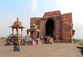
Teli ka Mandir, Gwalior Fort
Shiva Temple in Bhojpur

Lakshmi Temple, Orchha

Brahma statue with various deities at Amarkantak.
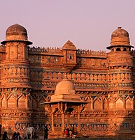
Gwalior Fort, Gwalior

Gwalior Fort


.JPG)


Geography
Location in India
Madhya Pradesh literally means "Central Province", and is located in the geographic heart of India in between the latitude of 21.6°N–26.30°N and longitude of 74°9'E–82°48'E. The state straddles the Narmada River, which runs east and west between the Vindhya and Satpura ranges; these ranges and the Narmada are the traditional boundaries between the north and south of India. The highest point in Madhya Pradesh is Dhupgarh, with an elevation of 1,350 m (4,429 ft).[25]
The state is bordered on the west by Gujarat, on the northwest by Rajasthan, on the northeast by Uttar Pradesh, on the east by Chhattisgarh, and on the south by Maharashtra.
Places adjacent to Madhya Pradesh | ||||||||||
|---|---|---|---|---|---|---|---|---|---|---|
| ||||||||||

Climate
Madhya Pradesh also has three major seasons – Summer, Monsoon, and Winter. During summer (March–June), the temperature in the entire state ranges above 34.6 it has increased as it is all time high in Madhya Pradesh. In general, the eastern parts of Madhya Pradesh are hotter than the western parts. The regions like Gwalior, Morena and Datia record temperatures of over 42 °C in May. The humidity is relatively very low and the region usually experiences frequent mild dust storms. The southwest Monsoon usually breaks out in mid-June and the entire state receives a major share of its rainfall between June and September. The south and south-east regions tend to experience a higher rainfall whereas the parts of the north-west receive less. Mandla, Balaghat, Sidhi, Jabalpur, and other extreme eastern parts receive more than 150 cm of rainfall. The districts of western Madhya Pradesh receive less than 80 cm of rainfall.[26]
The winter season starts in November. The temperature remains low in the northern parts of the state in comparison to the southern parts. The daily maximum temperature in most of the northern part of January remains between 15 and 18 °C. The climate is generally dry and pleasant with a clear sky. The average rainfall is about 1,194 mm (47.0 in). The southeastern districts have the heaviest rainfall, some places receiving as much as 2,150 mm (84.6 in), while the western and northwestern districts receive 1,000 mm (39.4 in) or less.
Ecology
According to the 2011 figures, the recorded forest area of the state is 94,689 km2 (36,560 sq mi) constituting 30.7% of the geographical area of the state.[27] It constitutes 12.3% of the forest area of India. Legally this area has been classified into "Reserved Forest" (65.3%), "Protected Forest" (32.8%) and "Unclassified Forest" (0.2%). Per capita forest area is 2,400 m2 (0.59 acres) as against the national average of 700 m2 (0.17 acres). The forest cover is less dense in the northern and western parts of the state, which contain the major urban centres. Variability in climatic and edaphic conditions brings about significant difference in the forest types of the state. In January 2019 1.5 million volunteers in the state planted 66 million trees in 12 hours along the Narmada river.[28]
The major types of soils found in the state are:
- Black soil, most predominantly in the Malwa region, Mahakoshal and in southern Bundelkhand
- Red and yellow soil, in the Baghelkhand region
- Alluvial soil, in Northern Madhya Pradesh
- Laterite soil, in highland areas
- Mixed soil, in parts of the Gwalior and Chambal divisions
Flora and fauna
Madhya Pradesh is home to ten National Parks; Bandhavgarh National Park, Kanha National Park, Satpura National Park, Sanjay National Park, Madhav National Park, Van Vihar National Park, Mandla Plant Fossils National Park, Panna National Park, Pench National Park and Dinosaur National Park, Dhar.[29][30]
There are also a number of nature reserves, including Amarkantak, Bagh Caves, Balaghat, Bori Natural Reserve, Ken Gharial, Ghatigaon, Kuno Palpur, Narwar, Chambal, Kukdeshwar, Chidi Kho, Nora Dehi, Pachmarhi, Panpatha, Shikarganj, Patalkot, and Tamia. Pachmarhi Biosphere Reserve in Satpura Range, Amarkantak biosphere reserve and Panna National Park are three of the 18 biosphere reserves in India. Most of them are located in eastern Madhya Pradesh near Jabalpur.

Langur monkey (Semnopithecus dussumieri), Orchha

Tigress with cubs in Kanha Tiger Reserve

Tickell's blue flycatcher, Bandhavgarh National Park

Vultures in the nest, Orchha

Male nilgais fighting, Lakeshwari, Gwalior district


.jpg)


Kanha, Bandhavgarh, Pench, Panna, and Satpura National Parks are managed as Project Tiger areas. The National Chambal Sanctuary is managed for conservation of gharial and mugger, river dolphin, smooth-coated otter and a number of turtle species. Ken-gharial and Son-gharial sanctuaries are managed for conservation of gharial and mugger. The barasingha is the state animal and the dudhraj is the state bird of Madhya Pradesh.
Based on composition, the teak and sal forests are the important forest formations in the state. Bamboo-bearing areas are widely distributed.
State symbols of Madhya Pradesh
| Title | Symbol | Image |
|---|---|---|
| State animal | Barasingha[31][32] (Rucervus duvaucelii) | 
|
| State bird | Indian paradise flycatcher (Terpsiphone paradisi)[33] | 
|
| State tree | banyan tree (ficus bengalensis)[34] | 
|
| State fish | Mahasheer (Tor tor)[33] | 
|
| State Flower | Madonna lily (Lilium candidum)[35] | 
|
Rivers

Narmada River

Son River, Umaria district, MP, India

The River Narmada flows through a gorge of marble rocks in Bhedaghat, Jabalpur

The Shri Ram Ghat on the Shipra River in Ujjain

Betwa in the Ashoknagar District of Madhya Pradesh


The Narmada is the longest river in Madhya Pradesh. It flows westward through a rift valley, with the Vindhya ranges sprawling along its northern bank and the Satpura range of mountains along the southern. Its tributaries include the Banjar, the Tawa, the Machna, the Shakkar, the Denwa and the Sonbhadra rivers. The Tapti River runs parallel to Narmada, and also flows through a rift valley. The Narmada–Tapti systems carry an enormous volume of water and provide drainage for almost a quarter of the land area of Madhya Pradesh. The Narmada river is considered very sacred and is worshipped throughout the region. It is the main source of water and acts as a lifeline to the state.
The Vindhyas form the southern boundary of the Ganges basin, with the western part of the Ganges basin draining into the Yamuna and the eastern part directly into the Ganges itself. All the rivers, which drain into the Ganges, flow from south to north, with the Chambal, Shipra, Kali Sindh, Parbati, Kuno, Sind, Betwa, Dhasan and Ken rivers being the main tributaries of the Yamuna. Shipra River is one of the most sacred rivers of Hinduism. It is the site of the Simhastha Kumbh Mela, which is held every 12 years. The land drained by these rivers is agriculturally rich, with the natural vegetation largely consisting of grass and dry deciduous forest types, largely thorny. The eastern part of the Ganges basin consists of the Son, the Tons and the Rihand Rivers. Son, which arises in the Maikal hills around Amarkantak, is the largest tributary that goes into the Ganges on the south bank and that does not arise from the Himalayas. Son and its tributaries contribute the bulk of the monsoon flow into the Ganges, because the north bank tributaries are all snow fed. The forests in their basins are much richer than the thorn forests of the northwestern part of Madhya Pradesh.
After the formation of Chhattisgarh State, the major portion of Mahanadi basin now lies in Chhattisgarh. Presently, only 154 km2 basin area of Hasdeo River in Anuppur District lies in Madhya Pradesh.
The Satpuras, in the Gawilgarh and Mahadeo Hills, also contain a watershed, which is south facing. The Wainganga, the Wardha, the Pench, the Kanhan rivers, discharge an enormous volume of water into the Godavari river system. The Godavari basin consists of sub-tropical, semi-moist forests, mainly in the valley of the Indrawati. There are many important multi-state irrigation projects in development, including the Godavari River Basin Irrigation Projects.
Regions
Madhya Pradesh is divided into the following agro-climatic zones:
Administration
Madhya Pradesh is divided into 52 districts for administrative purposes. The district is the main unit of administration. These districts are arranged in 10 divisions, listed below:[36]
Cities
| Rank | District | Pop. | |||||||
|---|---|---|---|---|---|---|---|---|---|
 Indore  Bhopal |
1 | Indore | Indore | 2,167,447 |  Jabalpur  Gwalior | ||||
| 2 | Bhopal | Bhopal | 1,883,381 | ||||||
| 3 | Jabalpur | Jabalpur | 1,267,564 | ||||||
| 4 | Gwalior | Gwalior | 1,101,981 | ||||||
| 5 | Ujjain | Ujjain | 593,368 | ||||||
| 6 | Sagar | Sagar | 370,296 | ||||||
| 7 | Dewas | Dewas | 289,438 | ||||||
| 8 | Satna | Satna | 283,004 | ||||||
| 9 | Ratlam | Ratlam | 273,892 | ||||||
| 10 | Rewa | Rewa | 235,422 | ||||||
Demographics
Population
| Year | Pop. | ±% |
|---|---|---|
| 1951 | 18,615,000 | — |
| 1961 | 23,218,000 | +24.7% |
| 1971 | 30,017,000 | +29.3% |
| 1981 | 38,169,000 | +27.2% |
| 1991 | 48,566,000 | +27.2% |
| 2001 | 60,348,000 | +24.3% |
| 2011 | 72,597,565 | +20.3% |
| Source: Census of India[38] | ||
The population of Madhya Pradesh consists of a number of ethnic groups and tribes, castes and communities. The scheduled castes and the scheduled tribes constitute a significant portion of the population of the State 15.6% and 21.1% respectively.
The main tribal groups in Madhya Pradesh are Gond, Bhil, Baiga, Korku, Bhadia (or Bhariya), Halba, Kaul, Mariya, Malto and Sahariya. Mandla, Dhar, Dindori, Barwani, Jhabua and Alirajpur districts have more than 50% tribal population, with Jhabua and Alirajpur having nearly 90% tribal population. In Khargone, Khandwa, Burhanpur, Betul, Chhindwara, Seoni, Anuppur, Umaria, Shahdol and Singrauli districts 30–50% of the population is tribal. According to the 2011 census, the tribal population in Madhya Pradesh was 15.34 million, constituting 21.1% of the total population. There were 46 recognised Scheduled Tribes and three of them have been identified as "Special Primitive Tribal Groups" in the State.[39]
Madhya Pradesh ranks(33rd) on the Human Development Index value of 0.606 (2018).[40] According to the SDG India Index 2020–21 compiled by the NITI AAYOG, Madhya pradesh ranks 21 on sustainable development goals. The state's per-capita gross state domestic product (nominal GDP) is the 26th in the country (2018–19).[41] According to NITI Aayog SDGs India index the state ranks 9th on gender equality, 10th on clean water and sanitation.[42]

Children in Raisen district, Bhil tribe

Shepherds in Chambal

A young farmer in Umaria district

Young Baiga women


Languages
The official language of the state is Hindi, which is spoken by over two-thirds of the population and is used for all government business.[4] In urban areas Standard Hindi is the main language, while Urdu is spoken by Muslims. In rural areas, however, most speak varieties counted as dialects of Hindi in the census, although most are quite distinct. In the west are Malvi and Nimadi in the Malwa and Nimar regions, which are more closely related to the Rajasthani languages. In Bundelkhand in the north and Baghelkhand in the east are spoken Bundeli and Bagheli which are eastern varieties of the Hindi languages, similar to Awadhi or Chhattisgarhi. In the southeast is spoken Chhattisgarhi and Powari is the language of the far south, both Eastern Hindi languages. Most speakers of these languages consider them to be dialects of Hindi and so report their language as 'Hindi' on the census.[43]
Marathi is another significant language. Due to Maratha rule over much of what is now Madhya Pradesh, Madhya Pradesh is home to the largest number of Marathis outside Maharashtra. Although large numbers of Marathis can be found in urban centres like Indore, the highest concentrations are in the southern areas of the state adjoining Maharashtra. Marathi is the most-spoken language in Burhanpur district, while it is a major minority language in the southern parts of Mahakoshal especially Betul, Chhindwara and Balaghat districts.[43]
There are several languages spoken by the Adivasis. The various Bhil languages are Indo-Aryan languages spoken by 50 lakh Bhils of western Madhya Pradesh. Although many, especially in the eastern parts of their range, have adopted the regional languages as mother tongue, the languages are still strong in the far-western hills especially Barwani, Jhabua and Alirajpur districts where they are in the majority. Bhili, the Bareli languages and Bhilali are the major varieties spoken in the state.
Gondi is the second-largest Adivasi language, spoken by 11 lakh Gonds in the state. A Dravidian language related to Telugu, it is mainly spoken in the southern Satpura highlands of Mahakoshal, where it is spoken with the regional languages. Some in the remoter valleys of the Satpuras speak a poorly-described Dravidian dialect called Bharia. Smaller minorities of Gondi speakers can be found in Khandwa and Dewas districts in the west as well as Anuppur, Sidhi and Singrauli districts in the east. Elsewhere in the state, the Gonds have almost totally abandoned their original language.
Korku, a Munda language, has over 4 lakh speakers in the central highlands of the state. In the far-southeast of Burhanpur can be found some speakers of the language isolate Nihali who live among the Korku. All speakers of tribal languages face significant pressure to switch to the dominant regional languages while their own tongues are considered 'backward' and 'rural'.[43]
The following languages are taught in schools in Madhya Pradesh under the Three Language Formula:[44]
First language: Any Scheduled Language
Second language: Hindi, Urdu or English
Third language: Another Scheduled Language, Arabic, Persian, French, Russian
Religion
Hinduism is the main religion and is followed by 90.9% of the population.
According to the census of 2011, 90.9% of residents followed Hinduism, while minorities are Muslim (6.6%), Jain (0.8%), Buddhists (0.3%), Christians (0.3%), and Sikhs (0.2%). Madhya Pradesh is home to several pilgrimage sites including Amarkantak at the source of the Narmada and the Ghats of Omkareshwar, also on the Narmada. Temples can be found throughout the state. Buddhism and Jainism were once prominent religions in the state, especially in the central plateau near Raisen and Bhopal. Malwa is still home to a significant Jain minority. Jains are particularly concentrated in the urban centres of the Malwa region. Islam arrived with Muslim rule in the 14th century, although its influence was and is limited to major urban centres. Islam is a major religion in Bhopal and Burhanpur, and Bhopal is home to many prominent Islamic shrines. Buddhism in modern times is mainly practiced by Marathis in the south. Most respondents who answered 'Other' self-identified as following Adivasi religions such as Koya Punem of the Gonds.[45]
Culture

Bagh Print Traditional hand block print craft in Bagh.
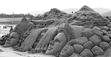
Sand sculpture by Sudarshan Pattnaik at Bandrabhan near Narmadapuram


Three sites in Madhya Pradesh have been declared World Heritage Sites by UNESCO: the Khajuraho Group of Monuments (1986) including Devi Jagadambi temple, Khajuraho, Buddhist Monuments at Sanchi (1989) and the Rock Shelters of Bhimbetka (2003). Other architecturally significant or scenic sites include Ajaigarh, Amarkantak, Asirgarh, Bandhavgarh, Bawangaja, Bhopal, Vidisha, Chanderi, Chitrakuta, Dhar, Gwalior, Indore, Nemavar, Jabalpur, Burhanpur, Maheshwar, Mandleshwar, Mandu, Omkareshwar, Orchha, Pachmarhi, Shivpuri, Sonagiri, Mandla and Ujjain.
Madhya Pradesh is noted for its classical and folk music. Some of the noted Hindustani classical music gharanas in Madhya Pradesh include the Maihar gharana, the Gwalior gharana and Senia gharana. Two of the medieval India's most noted singers, Tansen and Baiju Bawra, were born near Gwalior in present-day Madhya Pradesh. Noted Dhrupad exponents Aminuddin Dagar (Indore), Gundecha Brothers (Ujjain) and Uday Bhawalkar (Ujjain) were also born in present-day Madhya Pradesh.[46] Renowned classical singer Kumar Gandharva spent his life at Dewas. The birthplaces of noted playback singers Kishore Kumar (Khandwa) and Lata Mangeshkar (Indore) and singer and composer Aadesh Shrivastava (Jabalpur) are also located in MP. The local styles of folk singing include Faga, Bhartahari, Sanja geet, Bhopa, Kalbelia, Bhat/Bhand/Charan, Vasdeva, Videsia, Kalgi Turra, Nirgunia, Alha, Pandwani Gayan and Garba Garbi Govalan.[47]
The major folk dances of MP are Rai, Karma, Saila, Matki, Gangaur, Badhai, Baredi, Naurata, Ahiri and Bhagoria.[48]
Economy
Madhya Pradesh's gross state domestic product (nominal GDP) for 2013–14 was ₹ 4,509 billion (approximately US$ 72,726,000,000). The per-capita figure was US$ 871.45 in 2013–14, the sixth-lowest in the country.[49] Between 1999 and 2008, the annualised growth rate of the state was very low: 3.5%.[50] Subsequently, the state's GDP growth rate has improved significantly, rising to 8% during 2010–11 and 12% during 2011–12.[51]
Madhya Pradesh is also famous for honey production in district Morena.
The state has an agrarian economy.[51] The major crops of Madhya Pradesh are wheat, soybean, gram, sugarcane, rice, maize, cotton, rapeseed, mustard and arhar.[52] Minor Forest Produce (MFP), such as tendu leaves used to roll beedi, sal seed, teak seed, and lak also contribute to state's rural economy.

Madhya Pradesh has 5 Special Economic Zones (SEZs): 3 IT/ITeS (Indore, Gwalior), 1 mineral-based (Jabalpur) and 1 agro-based (Jabalpur). In October 2011, approval was given to 14 proposed SEZs, out of which 10 were IT/ITeS-based.[52] Indore is the major commercial centre of the state. Because of the state's central location, a number of consumer goods companies have established manufacturing bases in MP.[52]
The state has the largest reserves of diamond and copper in India. Other major mineral reserves include those of coal, coalbed methane, manganese and dolomite.[52]
Madhya Pradesh has six Ordnance Factories, four of which are located at Jabalpur (Vehicle Factory, Grey Iron Foundry, Gun Carriage Factory, Ordnance Factory Khamaria) and one each at Katni and Itarsi. The factories are run by the Ordnance Factories Board, and manufacture a variety of products for the Indian Armed Forces.
Madhya Pradesh won the 10th National Award for excellent work in Mahatma Gandhi National Rural Employment Guarantee Act, 2005.
The state's tourism industry is growing, fuelled by wildlife tourism and a number of places of historical and religious significance. Sanchi and Khajuraho are frequented by external tourists. Besides the major cities, Bhedaghat, Jabalpur, Bhimbetka, Bhojpur, Maheshwar, Mandu, Orchha, Pachmarhi, Kanha, Amarkantak and Ujjain, Tumen Vindhyavasini temple ancient temple. This south facing Ashok Nagar district located in Tuman (Tumvn).
Infrastructure
Energy
| Power | Capacity (MW) |
|---|---|
| Thermal | 16,387.09
|
| Renewable | 5,180.78
|
| Hydro | 3,223.66
|
| Nuclear | 273.0
|
The state has a total installed power generation capacity of 24950.60 MW as of 30 November 2020. The Madhya Pradesh Electric Board is located at Jabalpur. The Rewa Ultra Mega Solar project is a photovoltaic solar park spread over an area of 1,590 acres (6.4 km2) in the Gurh tehsil of Rewa District of Madhya Pradesh.[54] The project was commissioned with 750 MW capacity.[55] 97% households have electricity access in the state.[56]
The Singrauli region on the eastern end of Madhya Pradesh is a major energy producer enclave for the country. The region has vast reserves of coal mines, which are excavated by Northern Coalfields Limited, a subsidiary of Coal India Limited, which is in turn used in local power plants of NTPC, Sasan Power and Hindalco. The area has more than 10,000 MW installed capacity for energy production.
Transport
| Road type | Length (in km) |
|---|---|
| National Highways | 8,772
|
| State Highways | 11,000
|
| Major District Roads | 19,241
|
Bus and train services cover most of Madhya Pradesh. The 99,043-kilometre-long (61,542 mi) road network of the state includes 20 national highways.[52] A 4,948-kilometre-long (3,075 mi) rail network criss-crosses the state, with Jabalpur serving as headquarters for the West Central Railway Zone of the Indian Railways. The Central Railway and the Western Railway also cover parts of the state. Most of the western Madhya Pradesh comes under Ratlam Rail Division of Western Railways, including cities like Indore, Ujjain, Mandsaur, Khandwa, Neemuch and Bairagarh in Bhopal. The state has a total of 20 major railway junctions. The major inter-state bus terminals are located in Bhopal, Indore, Gwalior and Jabalpur. More than 2,000 buses are conducted daily from these four cities. The intra-city transit systems mostly consist of buses, private autos and taxis. More than 455 trains transit through Madhya Pradesh daily. 220 trains transit through the State’s capital Bhopal alone. North–South & East–West corridors cut across Madhya Pradesh. There is convenient access to major ports such as Kandla port and Jawaharlal Nehru port in the state[57]
The state does not have a coastline. Most of the sea trade happens through the Kandla and Jawaharlal Nehru Port (Nhava Sheva) in the neighbouring states, which are well-connected to MP by road and rail networks.
Devi Ahilyabai Holkar Airport in Indore is the busiest airport in Madhya Pradesh. Raja Bhoj International Airport in Bhopal, Dumna Airport in Jabalpur, Gwalior Airport and Khajuraho Airport also have scheduled commercial passenger services. Besides these, minor airstrips are located at Chhindwara, Sagar, Neemuch, Ratlam, Mandsaur, Ujjain, Khandwa, Rewa, Guna and Satna.
Other
The state has 52 districts hospitals, 333 community health centres, 1,155 primary health centres and 8,860 sub-centres.[58][59]
The urban infrastructure has improved considerably in the past decade. 22 projects costing above $500 million have been sanctioned under the Jawaharlal Nehru National Urban Renewal Mission for the development of Bhopal, Indore, Jabalpur and Ujjain.[52]
Seven Cities of Madhya Pradesh Bhopal, Indore, Gwalior, Jabalpur, Satna, Ujjain, and Sagar have been selected under Smart cities mission[60][61]
Media
Dainik Bhaskar, Dainik Jagran, The Indian Observer, Nava Bharat, Deshbandhu, Nai Duniya, Rajasthan Patrika, Raj Express and Dainik Dabang Dunia are the leading Hindi newspapers. Other local newspapers are published in the cities. In English Times of India, Hindustan Times, The Hitavada, Central Chronicle and Free Press have editions from Bhopal with The Hitavada also being in Jabalpur. A Sindhi daily, i.e., Challenge (Now also in Hindi) is published from Bhopal is the only Sindhi newspaper in state.
Government and politics
Madhya Pradesh has a 230-seat state legislative assembly. The state also sends 40 members to the Parliament of India: 29 are elected to the Lok Sabha (Lower House) and 11 to the Rajya Sabha (Upper House). The constitutional head of the state is the Governor, appointed by the President of India. The execution powers lie with the Chief Minister, who is the elected leader of the state legislature. The current governor is Mangubhai C. Patel, and the current chief minister is Shivraj Singh Chouhan of the Bharatiya Janata Party (BJP).
The dominant political parties in the state are the Bharatiya Janata Party (BJP) and the Indian National Congress (INC).
Administration
Madhya Pradesh state is made up of 52 Districts, which are grouped into 10 divisions. As of 2020, the state has 52 jila (district) panchayats, 376 tehsil, 313 janpad panchayats/blocks, and 23043 gram (village) panchayats. The municipalities in the state include 18 Nagar Nigams, 100 Nagar Palikas and 264 Nagar Panchayats.[62]
Villages
Education

Rajiv Gandhi Technical University's main gate

IIM Indore's aerial panoramic view

St. Aloysius Senior Secondary School, Jabalpur, established in the year 1868 is among the oldest schools in India


%27s_Matang_Truck_for_the_Indian_Army.jpg)
According to the 2011 census, Madhya Pradesh had a literacy rate of 69.32%. According to the 2009–10 figures, the state had 105,592 primary schools, 6,352 high schools, and 5,161 higher secondary schools. The state has 208 engineering and architecture colleges, 208 management institutes, and 12 medical colleges.[52]
The state is home to some of the premier educational and research institutions of India including IIT Indore, IIM Indore, AIIMS Bhopal, NIT Bhopal, IIITDM Jabalpur, IIITM Gwalior, Indian Institute of Tourism and Travel Management (IITTM Gwalior), Indian Institute of Science Education and Research (IISER) Bhopal, School of Planning and Architecture, Bhopal, Indian Institute of Forest Management (IIFM) Bhopal, National Law Institute University (NLIU) Bhopal Jabalpur Engineering College, Dharmashastra National Law University, Jabalpur.
There are 500 degree colleges, which are affiliated with one of the universities in the state. The specialised universities include Rajiv Gandhi Technical University, Madhya Pradesh Medical Science University, Jawaharlal Nehru Agriculture University and Nanaji Deshmukh Veterinary Science University. The general universities are Awadhesh Pratap Singh University (Rewa), Barkatullah University (Bhopal), Devi Ahilya Vishwavidyalaya (Indore), Rani Durgavati University (Jabalpur), Vikram University (Ujjain), Jiwaji University (Gwalior), Dr. Hari Singh Gour University (Sagar), Indira Gandhi National Tribal University (Amarkantak, Anuppur), Makhanlal Chaturvedi National University of Journalism and Communication (Bhopal).
The Professional Examination Board was initialised as Pre Medical Test Board by Government of Madhya Pradesh in the year 1970. After some year in 1981, Pre Engineering Board was constituted. Then after, in the year 1982 both these boards were amalgamated and named as Madhya Pradesh Professional Examination Board (MPPEB).
Tourism
Notable people
Sports

In 2013, state govt declared Mallakhamba as the state sport.[63]
Cricket, kabaddi, hockey, football, basketball, volleyball, cycling, swimming, badminton, and table tennis are the popular sports in the state. Traditional games like kho kho, gilli danda, sitoliya, kanche, and langdi are popular in the rural areas.
Snooker, a cue sport, generally regarded as having been invented in Jabalpur by British Army officers, is popular in many of the English-speaking and Commonwealth countries, with top professional players attaining multimillion-pound career earnings from the game.

Cricket is the most popular sport in Madhya Pradesh.[citation needed] There are three international cricket stadiums in the state – Nehru Stadium (Indore), Roop Singh Stadium (Gwalior) and Holkar Cricket Stadium (Indore). Madhya Pradesh cricket team's best performances in Ranji Trophy was in 1998–99, when the Chandrakant Pandit-led team ended as the runner-up. Its predecessor, the Indore-based Holkar cricket team, had won the Ranji Trophy four times. In year 2022, Chandrakant Pandit coached Madhya Pradesh cricket team defeated 41 time champion Mumbai Cricket Team in Ranji Trophy 2021-2022 season. It is Madhya Pradesh's maiden title at M. Chinnaswamy Stadium.[64]
Aishbagh Stadium in Bhopal is the home ground for World Series Hockey team Bhopal Badshahs. The state also has a football team that participates in the Santosh Trophy.
MP United FC is an Indian football that played in the 2nd Division I-League.
On 6 December 2017, the Madhya Pradesh Chief Minister Shivraj Singh Chouhan announced that players from the state would be given government jobs on winning medals in international events.
Madhu Yadav, the former Captain of the India women's national field hockey team, a 1982 Asian Games gold medallist and an Arjuna Award recipient, is from Jabalpur.[65]
See also
- Outline of Madhya Pradesh
- Directorate Sports and Youth Welfare
- Districts of Madhya Pradesh
- List of forts in Madhya Pradesh
- List of people from Madhya Pradesh
References
- ↑ "MP: State Song to be Sung Along with National Anthem". Outlook. 12 October 2010. Archived from the original on 21 March 2020. Retrieved 21 March 2020.
- ↑ Noronha, Rahul (23 March 2020). "BJP's Shivraj Singh Chouhan sworn in as Madhya Pradesh CM for fourth time". India Today. Archived from the original on 19 November 2021. Retrieved 23 March 2020.
- ↑ "2011 Census of India" (PDF). Censusindia.gov.in. Archived from the original (PDF) on 17 October 2011. Retrieved 14 September 2012.
- ↑ 4.0 4.1 "Report of the Commissioner for linguistic minorities: 47th report (July 2008 to June 2010)" (PDF). Commissioner for Linguistic Minorities, Ministry of Minority Affairs, Government of India. pp. 122–126. Archived from the original (PDF) on 13 May 2012. Retrieved 16 February 2012.
- ↑ 5.0 5.1 "MOSPI State Domestic Product, Ministry of Statistics and Programme Implementation, Government of India". 15 March 2021. Archived from the original on 15 April 2021. Retrieved 28 March 2021.
- ↑ "Sub-national HDI – Area Database". Global Data Lab. Institute for Management Research, Radboud University. Archived from the original on 23 September 2018. Retrieved 25 September 2018.
- ↑ "Sex ratio of State and Union Territories of India as per National Health survey (2019-2021)". Ministry of Health and Family Welfare, India.
- ↑ Template:MW
- ↑ "Archived copy" (PDF). Archived (PDF) from the original on 5 February 2020. Retrieved 30 October 2019.
{{cite web}}: CS1 maint: archived copy as title (link) - ↑ "Human Development Index Across Indian States: Is the Glass Still Half Empty?" (PDF). Archived (PDF) from the original on 9 June 2021. Retrieved 9 June 2021.
- ↑ "India State of Forest Report 2019" (PDF).
- ↑ "Madhya Pradesh topped the National Tourism Awards 2010–11". jagranjosh.com. 1 January 2012. Archived from the original on 19 June 2012. Retrieved 14 September 2012.
- ↑ "Madhya Pradesh topples Bihar, new No 1 in economic growth". Economic Times. 30 March 2013. Archived from the original on 2 April 2013. Retrieved 30 March 2013.
- ↑ "Madhya Pradesh Presentation and Economy Growth Report | IBEF". www.ibef.org. Archived from the original on 28 February 2017. Retrieved 26 February 2021.
- ↑ "The Hathnora Skull Fossil from Madhya Pradesh, India" (PDF). Geological Survey of India. 20 September 2005. Archived from the original (PDF) on 16 September 2012. Retrieved 8 September 2012.
- ↑ Kenneth A. R. Kennedy (2000). God-Apes and Fossil Men: Paleoanthropology of South Asia. University of Michigan Press. pp. 206–. ISBN 978-0-472-11013-1. Archived from the original on 7 June 2013. Retrieved 8 September 2012.
- ↑ Vinod Chandra Srivastava (2 January 2008). History of Agriculture in India, Up to C. 1200 A.D. Concept Publishing Company. pp. 309–317. ISBN 978-81-8069-521-6. Archived from the original on 6 June 2013. Retrieved 8 September 2012.
- ↑ Ancient India by Ramesh Chandra Majumdar: p. 134.
- ↑ Verma, Archana (2007). Cultural and Visual Flux at Early Historical Bagh in Central India, Oxford: Archaeopress, ISBN 978-1-4073-0151-8, p. 19.
- ↑ A Journey through India's Past (Great Hindu Kings after Harshavardhana), by Chandra Mauli Mani: p. 13.
- ↑ A Brief History of India by Alain Daniélou p. 185.
- ↑ History of India by N. Jayapalan pp. 149–151.
- ↑ Dwarka Prasad Misha, ed. (1956). The History of freedom movement in Madhya Pradesh. Govt. Print., Madhya Pradesh.
- ↑ "जबलपुर के हाथ से बस इसलिए निकल गई राजधानी की प्रबल दावेदारी". Patrika.com. Archived from the original on 15 November 2017. Retrieved 25 July 2017.
- ↑ Madhya Pradesh for sight-seeing and shikar. Directorate of Information and Publicity, Madhya Pradesh. 1964. OCLC 8112689.
- ↑ "Government of Madhya Pradesh (M.P.)". Archived from the original on 9 June 2021. Retrieved 9 June 2021.
- ↑ State of Forest Report (PDF). Forest Survey of India (Ministry of Environment & Forests). 2011. Archived from the original (PDF) on 12 May 2013. Retrieved 10 September 2012.
- ↑ "India planted 66 million trees in 12 hours". The Independent. 3 July 2017. Archived from the original on 7 February 2019. Retrieved 5 February 2019.
- ↑ Wild Life Archived 13 November 2012 at the Wayback Machine. Forest Department, Madhya Pradesh.
- ↑ "MP Govt. to set up National Dinosaur Fossil Park in Dhar district". Ummid.com. Archived from the original on 14 February 2018. Retrieved 5 February 2018.
- ↑ "Symbols of Madya Pradesh". knowindia.gov.in. Archived from the original on 12 November 2013. Retrieved 18 October 2013.
- ↑ "Symbols of Madya Pradesh". Archived from the original on 19 October 2013. Retrieved 18 October 2013.
- ↑ 33.0 33.1 "State Symbols of MP". Madhya Pradesh State Biodiversity Board. Archived from the original on 25 July 2016. Retrieved 25 June 2016.
- ↑ "Madhya Pradesh" (PDF). ENVIS Centre on Floral Diversity. Archived from the original (PDF) on 24 February 2016. Retrieved 16 February 2016.
- ↑ "State Animals, Birds, Trees and Flowers of India". ENVIS Centre on Forestry. Archived from the original on 8 March 2016. Retrieved 10 January 2017.
- ↑ "MPOnline: Contact Government". Mponline.gov.in. Archived from the original on 2 August 2018. Retrieved 26 August 2018.
- ↑ "Urban Agglomerations/Cities having population 1 lakh and above" (PDF). Provisional Population Totals, Census of India 2011. Archived (PDF) from the original on 13 November 2011. Retrieved 13 February 2016.
- ↑ "Census Population" (PDF). Census of India. Ministry of Finance India. Archived from the original (PDF) on 19 December 2008. Retrieved 18 December 2008.
- ↑ [1][permanent dead link].
- ↑ Madhya Pradesh: Economic and Human Development Indicators Archived 16 September 2012 at the Wayback Machine, UNDP (2011).
- ↑ "GDP per capita of Indian states - StatisticsTimes.com". Archived from the original on 3 June 2021. Retrieved 9 June 2021.
- ↑ "Archived copy" (PDF). Archived (PDF) from the original on 12 June 2021. Retrieved 9 June 2021.
{{cite web}}: CS1 maint: archived copy as title (link) - ↑ 43.0 43.1 43.2 43.3 "Language – India, States and Union Territories" (PDF). Census of India 2011. Office of the Registrar General. pp. 13–14. Archived (PDF) from the original on 14 November 2018. Retrieved 15 December 2018.
- ↑ "51st Report of the Commissioner for Linguistic Minorities in India" (PDF). nclm.nic.in. Ministry of Minority Affairs. 15 July 2015. p. 64. Archived from the original (PDF) on 16 February 2018. Retrieved 15 February 2018.
- ↑ 45.0 45.1 "Percentage of Hindus, Sikhs in MP declines, of Muslims rises". Hindustan Times. 1 January 2016. Archived from the original on 29 January 2020. Retrieved 22 February 2020.
- ↑ Simon Broughton; Mark Ellingham; Richard Trillo (2000). World Music: Latin and North America, Caribbean, India, Asia and Pacific. Rough Guides. pp. 91–. ISBN 978-1-85828-636-5. Archived from the original on 6 June 2013. Retrieved 13 September 2012.
- ↑ "Folk Songs – govt-of-mp-india". Government of Madhya Pradesh. Archived from the original on 14 August 2017. Retrieved 14 August 2017.
- ↑ "Folk Dances – govt-of-mp-india". Government of Madhya Pradesh. Archived from the original on 14 August 2017. Retrieved 14 August 2017.
- ↑ "Per Capita Net State Domestic Product at Current Prices" (PDF). Archived from the original (PDF) on 25 December 2014. Retrieved 25 December 2014.
- ↑ "A special report on India: Ruled by Lakshmi 11 Dec 2008 from The Economist print edition". The Economist. Archived from the original on 10 March 2010. Retrieved 4 January 2009.
- ↑ 51.0 51.1 Lemuel Lall (29 June 2012). "Madhya Pradesh's GDP goes up to 12 per cent". The Times of India. Archived from the original on 2 May 2013. Retrieved 10 September 2012.
- ↑ 52.0 52.1 52.2 52.3 52.4 52.5 52.6 52.7 "Madhya Pradesh : The Land of Diamonds" (PDF). Ibef.org. November 2011. Archived from the original (PDF) on 27 September 2018. Retrieved 26 August 2018.
- ↑ "All India Installed Capacity (in MW) Of Power Stations (as on 30.11.2020))" (PDF). cea.nic.in. Central Electricity Authority, Government of India. Archived (PDF) from the original on 14 December 2020. Retrieved 23 December 2020.
- ↑ "Electricity | District Rewa, Government of Madhya Pradesh | India". Archived from the original on 10 July 2020. Retrieved 10 July 2020.
- ↑ "750 MW Rewa solar project starts supplying power". pv magazine India. Archived from the original on 12 July 2020. Retrieved 12 July 2020.
- ↑ "About Us | Energy Department, Government of Madhya Pradesh". Archived from the original on 9 June 2021. Retrieved 9 June 2021.
- ↑ "Infrastructure". Archived from the original on 9 June 2021. Retrieved 9 June 2021.
- ↑ "Madhya Pradesh: The Land of Diamonds" (PDF). India Brand Equity Foundation. March 2014. Archived from the original (PDF) on 10 August 2014. Retrieved 15 August 2014.
- ↑ Sharma, Rajendra (5 July 2018). "MP govt clears proposal for 52nd district". The Times of India. Archived from the original on 17 September 2018. Retrieved 3 November 2019.
- ↑ Jeelani, Mehboob (27 August 2015). "Centre unveils list of 98 smart cities; UP, TN strike it rich". The Hindu. ISSN 0971-751X. Archived from the original on 30 December 2017. Retrieved 4 September 2018.
- ↑ "Full list of 98 smart cities – Times of India ►". The Times of India. Archived from the original on 19 November 2021. Retrieved 4 September 2018.
- ↑ "Madhya Pradesh State Biodiversity Board". Mpsbb.info. Archived from the original on 17 March 2013. Retrieved 15 September 2012.
- ↑ Singhi, Ramendra. "State sport status to malkhamb". The Times of India. Archived from the original on 21 May 2017. Retrieved 24 December 2016.
- ↑ Purohit, Abhishek (27 June 2022). "Madhya Pradesh end long wait to win Ranji Trophy; beat Mumbai by 6 wickets". The Indian Express. Retrieved 28 June 2022.
- ↑ "Madhya Pradesh: Former Indian women's hockey team captain celebrates India's victory against Australia". Free Press Journal. Archived from the original on 7 August 2021. Retrieved 7 August 2021.
Further reading
- Gyanendra Singh. Farm Mechanization in Madhya Pradesh. Bhopal: Central Institute of Agricultural Engineering, 2000.
- Madhya Pradesh (India). The Madhya Pradesh Human Development Report 2002: Using the Power of Democracy for Development. [Bhopal: Govt. of Madhya Pradesh, 2002].
- Guru Radha Kishan Swatantrata Sangraam Senani from Madhya Pradesh: Archives Nehru Memorial Museum and Library, New Delhi.
- Rag, Pankaj. Vintage, Madhya Pradesh: A Collection of Old Photographs. Bhopal: Madhya Pradesh Madhyam jointly with the Directorate of Archaeology, Archives, and Museums, 2005. ISBN 81-902702-7-3
- Parmar, Shyam. Folk Tales of Madhya Pradesh. Folk tales of India series, 12". New Delhi: Sterling Publishers, 1973.
- Rag, Pankaj, and O. P. Misra. Masterpieces of Madhya Pradesh. Bhopal: Directorate of Archaeology, Archives & Museums, Government of Madhya Pradesh, 2005.
- Sampath, M. D., H. V. Trivedi, and Mandan Trivedi. Epigraphs of Madhya Pradesh. New Delhi: Archaeological Survey of India, 2001.
- Sati, Vishwambhar Prasad. Madhya Pradesh, a Geo-Economic Appraisal. Delhi: Abhijeet, 2004. ISBN 81-88683-43-4
- Shah, Shampa, and Aashi Manohar. Tribal Arts and Crafts of Madhya Pradesh. Living traditions of India. Ahmedabad: Mapin Pub./in Association with Vanya Prakashan, Bhopal, 1996. ISBN 0-944142-71-0
External links
- Government
{{URL|example.com|optional display text}}
- General information
- Madhya Pradesh web resources provided by GovPubs at the University of Colorado Boulder Libraries
- Madhya Pradesh at the Encyclopædia Britannica
- Madhya Pradesh at Curlie
 Wikimedia Atlas of Madhya Pradesh
 Geographic data related to Madhya Pradesh at OpenStreetMap