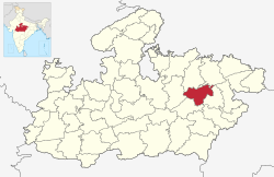
Katni district
Katni district | |
|---|---|
 Vijayraghav Fort | |
 Location of Katni district in Madhya Pradesh | |
| Country | |
| State | Madhya Pradesh |
| Division | Jabalpur |
| Headquarters | Katni |
| Government | |
| • District Magistrate | Mr.Prayank Mishra IAS |
| • Lok Sabha constituencies | Khajuraho |
| Area | |
| • Total | 4,949 km2 (1,911 sq mi) |
| Population (2011) | |
| • Total | 1,292,042 |
| • Density | 260/km2 (680/sq mi) |
| Demographics | |
| • Literacy | 73.62 per cent |
| • Sex ratio | 948 |
| Time zone | UTC+05:30 (IST) |
| Website | katni |
Katni district is one of the 51 districts of Madhya Pradesh state in central India. The town of Katni is the district headquarters. The district is part of Jabalpur Division. The district occupies an area of 4949.59 km².
Economy[edit | edit source]
Katni is a town in Madhya Pradesh with many laurels. It is also one of the largest rail junctions in the country and the second biggest diesel shed in the country is also located here. Katni is also a mineral-rich district, especially known for lime and bauxite.
In 2006 the Ministry of Panchayati Raj named Katni one of the country's 250 most backward districts (out of a total of 640).[1] It is one of the 24 districts in Madhya Pradesh currently receiving funds from the Backward Regions Grant Fund Programme (BRGF).[1]
Demographics[edit | edit source]
According to the 2011 census Katni District has a population of 1,292,042,[2] roughly equal to the nation of Estonia[3] or the US state of New Hampshire.[4] This gives it a ranking of 379th in India (out of a total of 640).[2] The district has a population density of 261 inhabitants per square kilometre (680/sq mi).[2] Its population growth rate over the decade 2001-2011 was 21.38%.[2] Katni has a sex ratio of 948 females for every 1000 males[2] and a literacy rate of 73.62%. Scheduled Castes and Scheduled Tribes made up 12.05% and 24.59% of the population respectively.[2]
Kols are the largest tribal group which is 41% of the tribal population, while Gonds (34%) and Bharias (20%) are the other major tribes.[2]
At the time of the 2011 Census of India, 97.98% of the population in the district spoke Hindi and 1.56% Sindhi as their first language.[6]
| Year | Pop. | ±% p.a. |
|---|---|---|
| 1901 | 249,049 | — |
| 1911 | 272,920 | +0.92% |
| 1921 | 272,832 | −0.00% |
| 1931 | 283,025 | +0.37% |
| 1941 | 333,078 | +1.64% |
| 1951 | 383,027 | +1.41% |
| 1961 | 452,246 | +1.68% |
| 1971 | 566,145 | +2.27% |
| 1981 | 714,508 | +2.35% |
| 1991 | 881,925 | +2.13% |
| 2001 | 1,064,167 | +1.90% |
| 2011 | 1,292,042 | +1.96% |
| source:[7] | ||
References[edit | edit source]
- ↑ 1.0 1.1 Ministry of Panchayati Raj (8 September 2009). "A Note on the Backward Regions Grant Fund Programme" (PDF). National Institute of Rural Development. Archived from the original (PDF) on 5 April 2012. Retrieved 27 September 2011.
- ↑ 2.0 2.1 2.2 2.3 2.4 2.5 2.6 "District Census 2011". Census2011.co.in. 2011. Retrieved 30 September 2011.
- ↑ US Directorate of Intelligence. "Country Comparison:Population". Retrieved 1 October 2011.
Estonia 1,282,963 July 2011 est.
- ↑ "2010 Resident Population Data". U. S. Census Bureau. Archived from the original on 1 January 2011. Retrieved 30 September 2011.
New Hampshire 1,316,470
- ↑ "C-16 Population By Religion - Madhya Pradesh". censusindia.gov.in. Office of the Registrar General & Census Commissioner, India.
- ↑ 2011 Census of India, Population By Mother Tongue
- ↑ Decadal Variation In Population Since 1901
External links[edit | edit source]
Template:Districts of Madhya Pradesh Template:Jabalpur Division
Coordinates: 23°50′08″N 80°23′39″E / 23.83556°N 80.39417°E