

This article needs additional citations for verification. (June 2014) |
Iritty | |
|---|---|
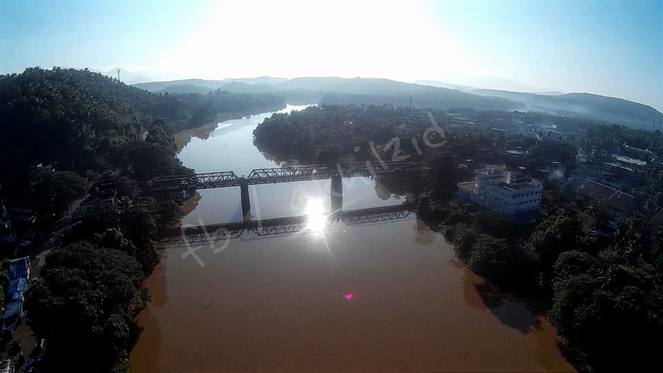
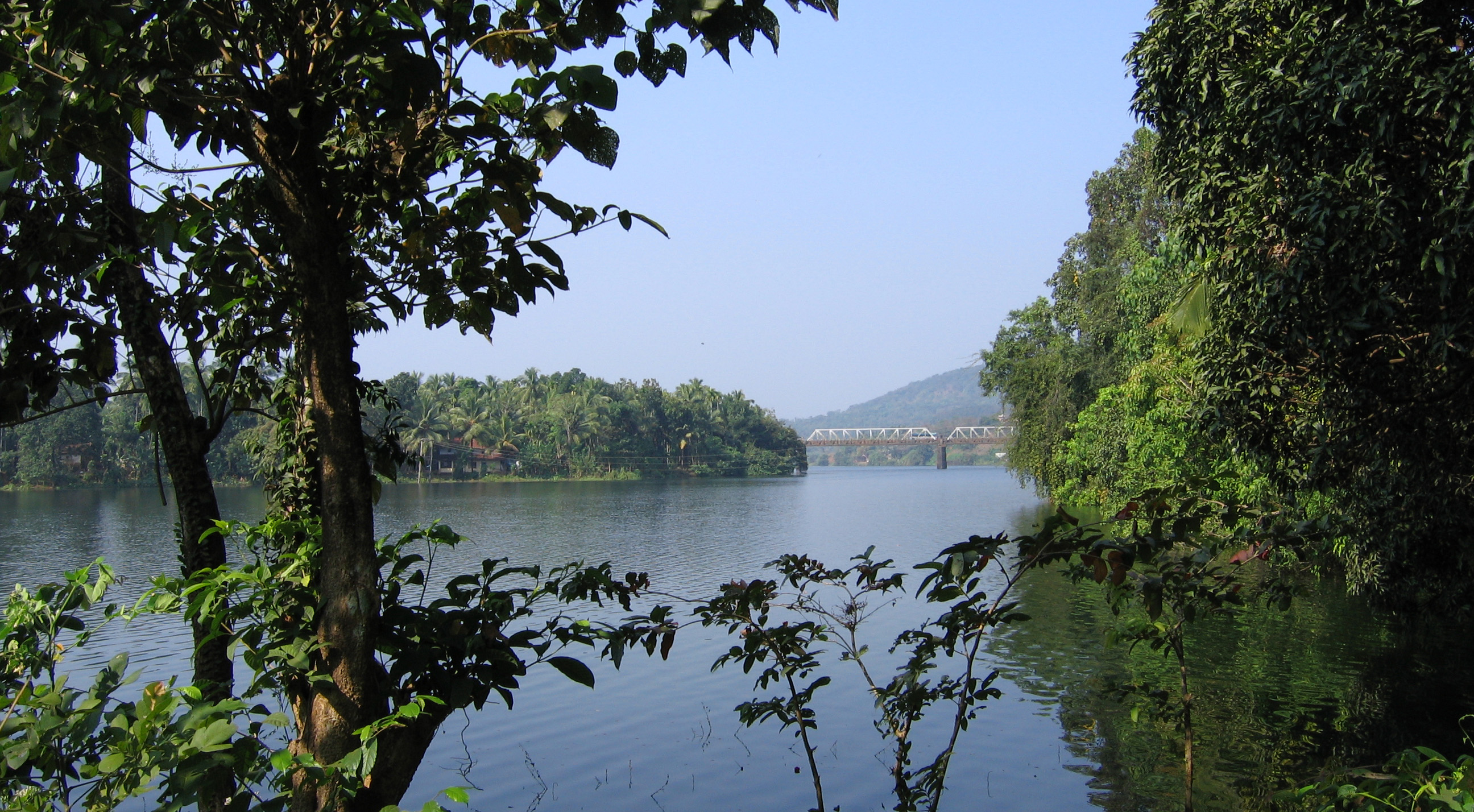
 View of Iritty Bridge built in 1933 | |
 Iritty Location in Kerala, India  Iritty Iritty (India) | |
| Coordinates: 11°58′55″N 75°40′13″E / 11.9819°N 75.6703°E | |
| Country | |
| State | Kerala |
| District | Kannur |
| Municipality Established | 1st April 2016 |
| Taluk | Iritty |
| Government | |
| • Type | Municipal Council |
| • Municipal Chairman | V. Vinod Kumar [1] |
| • Deputy Superintendent of Police | Yogesh Mandhaiya IPS [2] |
| Area | |
| • Total | 45.84 km2 (17.70 sq mi) |
| Elevation | 39 m (128 ft) |
| Population (2011) | |
| • Total | 40,369 |
| • Density | 880/km2 (2,300/sq mi) |
| Languages | |
| • Official | Malayalam, English |
| Time zone | UTC+5:30 (IST) |
| Telephone code | 91 (0)490 |
| ISO 3166 code | IN-KL |
| Vehicle registration | KL-78 |
| Sex ratio | 1066 ♂/♀ |
| Nearest city | Kannur |
| Assembly constituency | Peravoor |
| Lok Sabha constituency | Kannur |
Iritty is a municipality and taluk in Kannur district of Kerala state, India.[4] The town is the main market place for the farmer communities in the surrounding regions. Iritty is at a distance of 20 km (12 mi) from Kannur International Airport and one among five taluks in Kannur district. Iritty is one of the major towns that lies between Coorg and Kannur International Airport near Mattanur.[5]
Location[edit | edit source]

Iritty is located on the banks of Bavali river, which originates from the Wayanad passes.[6] Iritty is situated on the Thalassery-Coorg-Mysore highway and State Highway 30 (Kerala) between Mattanur and Virajpet. Some of the nearby smaller towns are Padiyoor, Blathur, Peravoor, Kakkayangad, Aralam, Keezhppally, Vallithode, Karikkottakary, Angadikadavu, Anappanthy, Edoor, Ulikkal, Vattiyamthode, Mattara, Manikkadavu, Kilyianthara, Punnad, Charal, Edapuzha, Uruppumkutti, Vilakkode and Chavassery.
Aralam Wildlife Sanctuary is situated 8 kilometres (5 mi) from Iritty.
Geography[edit | edit source]
Iritty is surrounded by hills. The Iritty Puzha (Iritty River). There is a steel girder bridge, built in 1933, over the river. Pazhassi Dam, almost 10 km from the town, provides irrigation.
Steel bridge[edit | edit source]

The steel bridge in Iritty is a 10-ton bridge constructed in 1933 by the British authorities to connect the towns of Kodagu and Thalassery.[7] It was designed by George Anderson of the Institution of Civil Engineers.[8][9] A July 2015 death of a man after being accidentally wedged between the handrail and a private bus raised concerns about the bridge's age.[7]
Administration[edit | edit source]
Iritty was initially part of Keezhur-Chavassery Panchayat and upgraded to a Municipality on 1 November 2015. The Municipal town is divided into 34 wards. V Vinod Kumar is the present municipal chairman of Iritty. The current ruling party of Iritty Municipality is LDF.[10]
Iritty Municipality is a part of Peravoor Assembly Constituency under Kannur Loksabha Constituency.[11]
Iritty established as a Taluk headquarters since March 2013 when Kerala government declared new taluks for the state. Iritty taluk falls under Thalassery Revenue division.[12]
Villages in Iritty Taluk[edit | edit source]
Iritty Taluk has 20 villages:
- Aralam, Ayyankunnu, Chavasseri and Kalliad
- Kanichar, Karikkottakari, Keezhur and Kelakam
- Kolari, Kottiyoor, Manathana and Muzhakkunnu
- Nuchiyad, Padiyoor, Payam and Pazhassi
- Thillankeri, Vayathur, Vellarvalli and Vilamana[13]
Law and Order[edit | edit source]
The municipality comes under the jurisdiction of Iritty police station, established on 11 November 1952. Before becoming a full fledged station, it was an outpost of Mattanur police station.[14]
Iritty Sub Division was formed on 09-02-2005 by merging areas from Panur Sub Division (previously under Thalassery). Later, when Kannur police district split into city and rural, Iritty subdivision was split into Peravoor and the current Iritty subdivisions. The subdivision consists of 5 police stations under its jurisdiction limits like Aralam, Karikkottakary, Ulikkal, Irikkur and Iritty. This subdivision shares its eastern border with Karnataka state, northern border with Taliparamba subdivision, western border with Kannur city district police and southern border with Peravoor subdivision.[15]
Iritty has a Grama Nyayalaya or village court situated at Payam for easy access to the judicial system in the rural areas.[16]
Climate[edit | edit source]
Iritty has a tropical monsoon climate (Am) with little to no rainfall from December to March and heavy to extremely heavy rainfall from April to November.
| Climate data for Iritty | |||||||||||||
|---|---|---|---|---|---|---|---|---|---|---|---|---|---|
| Month | Jan | Feb | Mar | Apr | May | Jun | Jul | Aug | Sep | Oct | Nov | Dec | Year |
| Average high °C (°F) | 31.6 (88.9) |
32.5 (90.5) |
33.6 (92.5) |
33.9 (93.0) |
33.2 (91.8) |
29.9 (85.8) |
28.6 (83.5) |
29.0 (84.2) |
29.7 (85.5) |
30.5 (86.9) |
31.0 (87.8) |
31.2 (88.2) |
31.2 (88.2) |
| Daily mean °C (°F) | 26.5 (79.7) |
27.5 (81.5) |
28.9 (84.0) |
29.8 (85.6) |
29.4 (84.9) |
26.9 (80.4) |
26.0 (78.8) |
26.2 (79.2) |
26.6 (79.9) |
27.0 (80.6) |
26.9 (80.4) |
26.3 (79.3) |
27.3 (81.2) |
| Average low °C (°F) | 21.4 (70.5) |
22.6 (72.7) |
24.3 (75.7) |
25.7 (78.3) |
25.6 (78.1) |
23.9 (75.0) |
23.4 (74.1) |
23.5 (74.3) |
23.5 (74.3) |
23.6 (74.5) |
22.9 (73.2) |
21.5 (70.7) |
23.5 (74.3) |
| Average precipitation mm (inches) | 3 (0.1) |
4 (0.2) |
12 (0.5) |
85 (3.3) |
283 (11.1) |
867 (34.1) |
1,332 (52.4) |
711 (28.0) |
329 (13.0) |
279 (11.0) |
106 (4.2) |
23 (0.9) |
4,034 (158.8) |
| Source: [17] | |||||||||||||
Transportation[edit | edit source]

Iritty lies at an equal distance from the nearby cities of Kannur, Thalassery, Mahe, Taliparamba and Virajpet (Karnataka State). The proposed Kannur Mysore National Highway or SH 30 passes through Iritty connecting Thalassery, Mattanur Airport and Kodagu. This was initially called the TC Road by the British. This highway is used by interstate bus services plying to Madikeri, Mysore and Bangalore.[18]
SH 36 connects Iritty with Taliparamba that gives access to other towns like Irikkur and Sreekandapuram.[19]
Keezhur is the starting point of Iritty town. This place is well-connected by road from both Kannur and Thalassery.[20] There are frequent buses from Iritty and to both these places and to several places across Kerala including Kottayam, Cochin (Ernakulam), Mangalore, Kasaragod, Panathur, Kanhangad, Cherupuzha, Wayanad and Kozhikode. There is no railway line, with the nearest railway stations at Kannur and Thalassery. The nearest airport is Kannur International Airport, at Mattannur is located 19.5 km south-west of Iritty.
Commerce[edit | edit source]
Iritty is one of the major towns of the Kannur district. Nearby villages produce cash crops and plantation crops, making Iritty a major commercial town. Iritty is famous for cash crops such as pepper, rubber and cashew nuts, some of which are sold under regional brands in various auction houses and commodities markets.
Iritty is primarily a trading town. Iritty is headquarters to several State Government offices. Most of these offices have jurisdiction over nearby towns like Mattanur and Peravoor.[21]

Religion[edit | edit source]
The following places provide religious services to Iritty:
- St. George Church Puravayal
- St. Mary's Forane Church, Edoor
- St. Joseph's Church Iritty
- Assemblies of God in India, Veerpad
InfantJesus Church, Ulikkal St.Sebastian forona Church Nellickampoyil
Notable people[edit | edit source]
- Tintu Luka, an Indian athlete[22]
- Nivetha Thomas, an Indian actress
References[edit | edit source]
- ↑ "Newly elected representatives of Municipalities in Kannur district".
- ↑ "Law and Order – Kannur Rural". keralapolice.gov.in. Archived from the original on 12 March 2024. Retrieved 12 March 2024.
- ↑ "iritty elevation map". topographic-map.com. Archived from the original on 26 August 2022. Retrieved 26 August 2022.
- ↑ "New Municipalities of Kerala : Election Results". Trend Kerala – Democracy. Archived from the original on 12 March 2016. Retrieved 20 March 2016.
- ↑ "Kudumbashree | City Profile in PMAY - Iritty". www.kudumbashree.org. Archived from the original on 5 July 2022. Retrieved 5 July 2022.
- ↑ "Iritty basic information". Archived from the original on 16 April 2008. Retrieved 12 March 2008.
- ↑ 7.0 7.1 Nazeer, Mohamed (2 August 2015). "Man's death puts spotlight on safety of Iritty bridge". The Hindu. ISSN 0971-751X. Archived from the original on 14 June 2021. Retrieved 6 December 2015.
- ↑ "Method of Erecting the Iritty Bridge, Malabar". The Railroad Gazette. Vol. 25. 24 March 1893. p. 224.
- ↑ "Method of Erecting the Iritty Bridge Malabar". The Railway Engineer. Vol. 14. June 1893. pp. 174–175.
- ↑ "LDF retains power in Iritty Municipality". The Hindu. 29 December 2020. Archived from the original on 30 September 2021. Retrieved 30 September 2021.
- ↑ "Assembly Constituencies – Corresponding Districts and Parliamentary Constituencies" (PDF). Kerala. Election Commission of India. Archived from the original (PDF) on 4 March 2009. Retrieved 18 October 2008.
- ↑ "12 new taluks to be formed in Kerala". The Hindu. 21 March 2013. Archived from the original on 15 November 2017.
- ↑ "Revenue Villages in Iritty Taluk" (PDF). Government of India. Retrieved 20 September 2020.
- ↑ "About - Iritty police station".
- ↑ "About - Iritty police sub division".
- ↑ "Courts in Thalassery district".
- ↑ "Iritty climate: Average Temperature, weather by month, Iritty weather averages – Climate-Data.org". en.climate-data.org. Archived from the original on 25 December 2021. Retrieved 25 December 2021.
- ↑ "Kannur-Mysuru corridor to be made NH". The Hindu. Archived from the original on 9 November 2020. Retrieved 26 July 2017.
- ↑ "Kerala State Highways". Kerala PWD Department. Archived from the original on 1 December 2010. Retrieved 13 May 2016.
- ↑ "Iritty More information of Iritty". Archived from the original on 16 October 2014. Retrieved 6 September 2014.
- ↑ "Kannur International Airport". Archived from the original on 2 August 2018. Retrieved 6 September 2014.
- ↑ "Road to Rio: Tintu Luka, India's best bet to end athletics medal wait at Olympics". The Indian Express. 22 July 2016. Archived from the original on 16 August 2016. Retrieved 17 August 2016.
.png)