

This article has multiple issues. Please help improve it or discuss these issues on the talk page. (Learn how and when to remove these template messages)
|


Lakkidi is a rain forest in the mid-lands, located in a gateway of the Wayanad district of the Indian state of Kerala. During the British rule in India, a horse track in Wayanad attracted several European investors and traders who then started cultivating Malabar pepper, spices, tea, and coffee. Today, the National Highway 766 (previously NH-212) connects Kozhikode in Kerala with Kollegal in Karnataka via Mysore, creating business opportunities in tourism and agriculture along it.[citation needed] Lakkidi is surrounded by a rich biodiverse environment and unspoiled nature which attracts several visitors interested in bird-watching, trekking, and off-road driving.[citation needed] Jawahar Navodaya Vidyalaya in Wayanad district is situated here.
Geography[edit | edit source]
Lakkidi is situated at one of the highest locations in Wayanad and is 700 m above the mean sea level, above Thamarassery ghat pass. Vythiri is the nearest town, which is 5 km from Lakkidi.[1] Chain tree, Pookot Lake and a mile-long viewing side-walk are within five km of Lakkidi. It is about 58 km northeast of Kozhikode district.
Three kilometers away from Lakkidi is Pookot Lake, a natural rain-fed lake spread across 15 acres. It is one of the few fresh-water reservoirs in Wayanad. Surrounded by meadows and hills, which is a favorite picnic spot among people. Annual rainfall here averages up to 600-650 cm causing seasonal floods downstream of rivers flowing east. Many species are found in this bio-reserve park including lion-tailed macaques, flying squirrels, wild buffalo, babblers, and rare water-birds like Indian Shag (Phalacrocorase fuscicollis), Little Cormorant (Phalacrocorax niger), Little Green Heron (Ardeola striatus), and Pond Heron (Ardeola grayii).
Lakkidi has rich soil that supports the farming of coffee, tea, orange and important spices pepper, cardamom and ginger. It receives highest mean annual rainfall in excess of 3000 mm in Wayanad and laterite, forest loamy and brown hydromorphic soil here retains moisture around the year.[2]
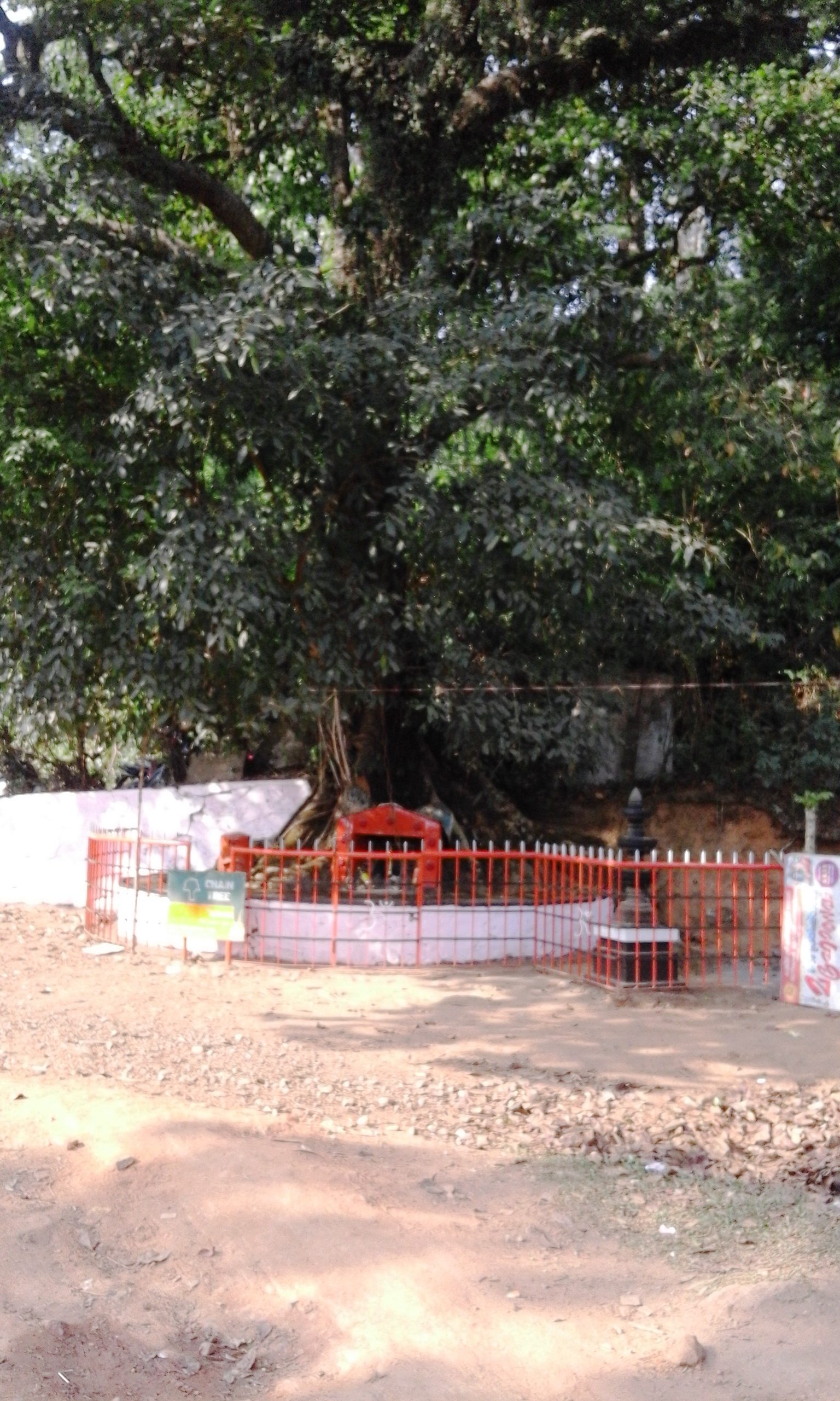
Annual Karinthandan Yatra[edit | edit source]
Karinthandan, the local chieftain of Paniyas, one of the tribes of Wayanad district, lived between 1700-1750 AD in the foothills of Lakkidi. A British engineer had observed him go uphill along a secret forest path and approached him to show the way through the thick forest towards the independent Kingdom of Mysore. This came to be known as the Thamarassery-Wayanad Ghat route.[3][circular reference] Once the engineer found his way, he killed the innocent man so that he could claim the honour and reward for finding this route. Years later, Karinthandan’s ghost started haunting every passer-by by appearing as a phantom figure and screaming threats, travellers were scared and met with fatal accidents and the whole region was haunted by the troubled spirit. Scared and desperate, the tribal people and traders of the region asked a witch doctor to help them. He exorcised the spirit and cast a spell to get rid of its evil powers and tied the imprisoned soul within a huge tree using an iron chain. This tree with a chain can still be seen near the highway at Lakkidi which has actually become a pilgrim spot and tourist attraction. PEEP Wayanad, an NGO working here since 2005, organises an annual yatra (walkathon) to commemorate the martyrdom of Karinthandan on the second Sunday of March. As a part of this yatra, essay writing competitions and sports events are also held to encourage tribal youth to join the mainstream. PEEP is promoted by Kerala Vanavasi Vikasa Kendram and the founders are Shri S. Ramanunni, Sri.M P Padmanabhan, Sri. E K Soman, Dr P Rajesh and Sri. T V Raghavan. PEEP, along with Paniya folk, has urged the government to install a statue of Karinthandan near the ‘chain tree' and name the ghat road as Karinthandan memorial ghat road. PEEP believes that this will improve the social esteem of the tribes and also help in boosting the tourism of the region.
Climate[edit | edit source]
Rains start in May and end in December. Due to the rainfall and beauty, it is often called "Chirapunjee of Kerala". Average rainfall ranges from 600 to 650 cm or above. It experiences chilly climate throughout the year with mist and fog. It is said to be the coldest place in Wayanad district as well as one of the coldest in Kerala. It enjoys koppen highland climate. Generally, monsoon comes with torrential rainfall and windy weather.
| Month | Jan. | Feb. | Mar. | Apr. | May | Jun. | Jul. | Aug. | Sep. | Oct. | Nov. | Dec. |
|---|---|---|---|---|---|---|---|---|---|---|---|---|
| High temp | 17 | 20 | 21 | 22 | 25 | 23 | 21 | 20 | 20 | 19 | 18 | 18 |
| Low temp | 6 | 10 | 13 | 15 | 17 | 16 | 15 | 14 | 12 | 11 | 10 | 8 |
Lakkidi experiences warm climate from March-May and cold climate from October to January.
Transport[edit | edit source]
From Kozhikode: Thamarassery–Lakkidi Ghat road, part of NH 212, connects Kozhikkode and the rest of Kerala, south of Kozhikkode with Wayanad. The Hill Road at Lakkidi is the lifeline of Wayanad. 1,813 buses and 591 minibuses pass through the Hill road every day. There are 17,207 vehicles that pass this road.