


Kasaragod District
Kanhirakode District[1] | |
|---|---|
| Kasaragod | |
      Clockwise from top: Ranipuram, Bekal Fort, Bekal beach, Chandragiri fort, Kavvayi Backwaters at Nileshwaram, Chandragiri River at Kanathur near Kasaragod. | |
| Nickname: The Land of Seven Languages[2] | |
| Coordinates: 12°30′N 75°00′E / 12.5°N 75°E | |
| Country | |
| State | Kerala |
| Region | North Malabar |
| Established | 24 May 1984 |
| Founded by | Government of Kerala |
| Headquarters | Kasaragod |
| Subdistricts | |
| Government | |
| • District Collector | Dr. D Sajith Babu IAS |
| • Superintendent of Police | P B Rajeev IPS |
| • MP | Rajmohan Unnithan (INC) |
| Area | |
| • Total | 1,992 km2 (769 sq mi) |
| Population (2018)[3] | |
| • Total | 1,390,894 |
| • Density | 698/km2 (1,810/sq mi) |
| Demographics | |
| • Language (2011) | |
| • Religion (2011) |
|
| Human Development | |
| • Sex ratio (2011) | 1080 ♀/1000 ♂[6] |
| • Literacy (2011) | 90.09%[7] |
| Time zone | UTC+5:30 (IST) |
| PIN | 671121 |
| Telephone code | 0499 |
| ISO 3166 code | IN-KL |
| Vehicle registration | KL-14, KL-60, KL-79 |
| HDI (2005) | |
| Website | kasargod |
Kasaragod ([kɑːsɾɡoːɖ] (![]() listen) and Malayalam: Kanhirakode,[1] English: Kassergode, Tulu: Kasrod, Arabic: Harkwillia[9]) is one of the 14 districts in the southern Indian state of Kerala. Its northern border Thalappady is located just 10 km south to Ullal, which is the southernmost portion of the major port city Mangalore, on the southwestern Malabar coast of India.
listen) and Malayalam: Kanhirakode,[1] English: Kassergode, Tulu: Kasrod, Arabic: Harkwillia[9]) is one of the 14 districts in the southern Indian state of Kerala. Its northern border Thalappady is located just 10 km south to Ullal, which is the southernmost portion of the major port city Mangalore, on the southwestern Malabar coast of India.
Kasaragod is the northernmost district of Kerala and is also known as Saptha Bhasha Sangama Bhoomi (The land of seven languages) as seven languages namely, Malayalam, Tulu, Kannada, Marathi, Konkani, Beary, and Urdu are spoken, unlike the other districts of Kerala.[2]
The district is situated on the rich biodiversity of Western Ghats. It was a part of the Kannur district of Kerala until 24 May 1984. The district is bounded by Dakshina Kannada district to the north, Western Ghats to the northeast, Kodagu district to the southeast, Kannur district to the south, and Arabian Sea to the west. Kasaragod district has the maximum number of rivers in Kerala - 12.[10]
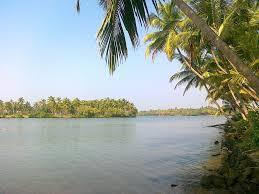
Kasaragod town is located on the estuary where the Chandragiri River, which is also the longest river in the district, empties into Arabian Sea. Kasaragod is home to several forts which include Arikady fort, Bekal Fort, Chandragiri Fort, and Hosdurg Fort (Puthiyakotta Fort). Bekal Fort is also the largest fort in Kerala. The historic hill of Ezhimala is located on the southern portion of Kavvayi Backwaters of Nileshwaram. Talakaveri, which is home to Talakaveri Wildlife Sanctuary where the 805 km long Kaveri River originates, is located closer to Ranipuram in Kerala-Karnataka border.
Etymology[edit | edit source]
Until 16th century CE, Kasargod town was known by the name Kanhirakode (meaning, 'The land of Kanhira Trees') in Malayalam.[1] Kasaragod is the Kannada version of Kanhirakode.
History[edit | edit source]
Ancient period[edit | edit source]

The Ancient Tamil Works of Sangam Age records that the area covering the district was part of Puzhinadu which consists of the coastal belt from Kozhikode to Mangalore. Politically the area was part of the Ezhimala Kingdom with its Capital at Ezhimala in present day Kannur district. The most famous King of Ezhimala was Nannan whose Kingdom extended up to Gudalur and northern parts of Coimbatore. Poozhinad, along woth Karkanad which included the eastern regions of Ezhimala dynasty (Wayanad-Gudalur region with some portions of Kodagu), had its capital at Ezhimala. The Mooshaka Kings were considered descendants of Nannan. By the 14th century, Mooshaka Kingdom was known as Kolathirinad and the Rulers as Kolathiris. The Kolathunad Kingdom at the peak of its power reportedly extended from Netravati River (Mangalore) in the north[11] to Korapuzha (Kozhikode) in the south with Arabian Sea on the west and Kodagu hills on the eastern boundary, also including the isolated islands of Lakshadweep in Arabian Sea.[12]
Medieval period[edit | edit source]


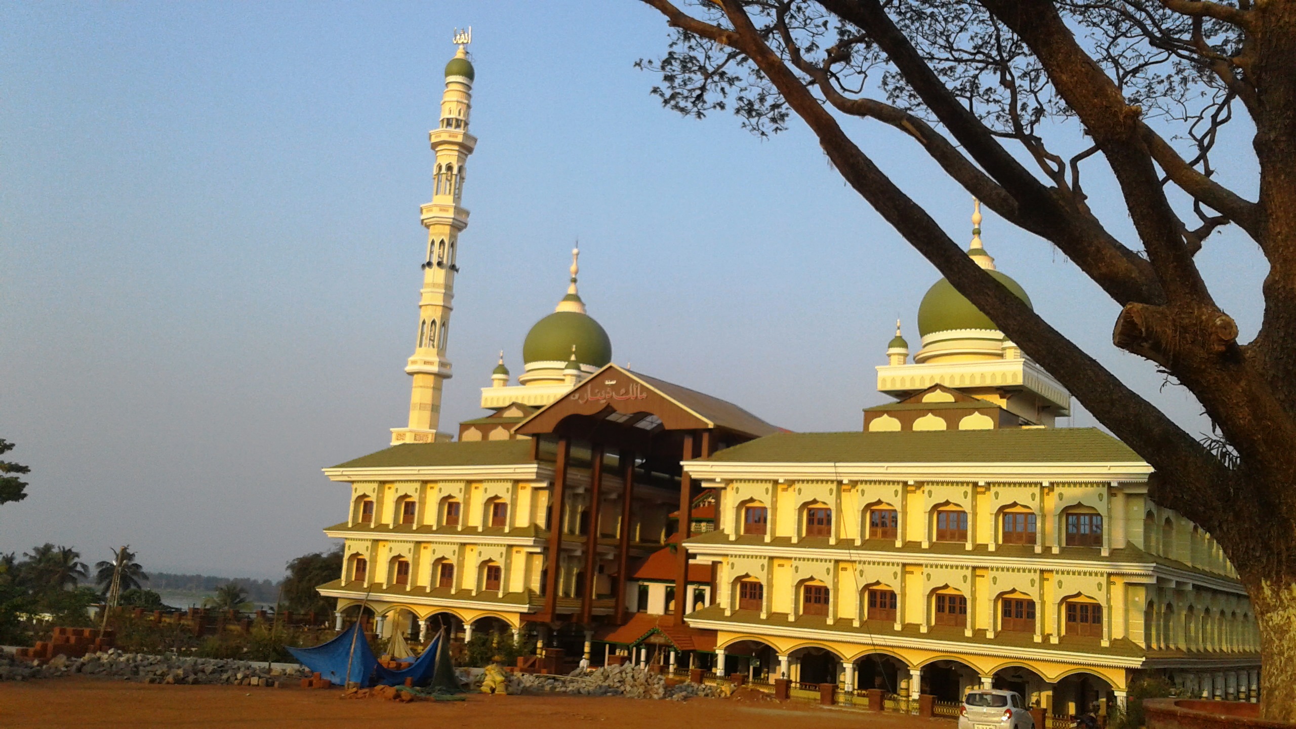
Ramacharitam, probably the oldest literary work written in Old Malayalam, which dates back to 12th century CE, is thought to have written in Kasargod district as its manuscripts were discovered from Nileshwaram and the poem mentions about Ananthapura Lake Temple in Kumbla in detail.[13] Kasaragod was known to the Arabs by the name Harkwillia.[9] Malik Dinar Mosque at Kasaragod town is one of the oldest mosques in Indian Subcontinent. According to Qissat Shakarwati Farmad, the Masjids at Kodungallur, Kollam, Madayi, Barkur, Mangalore, Kasaragod, Kannur, Dharmadam, Panthalayini, and Chaliyam, were built during the era of Malik Dinar, and they are among the oldest Masjids in Indian Subcontinent.[14] It is believed that Malik Dinar was died at Thalangara in Kasaragod town.[15]
Many Arab travelers visiting Kerala between the 9th and the 14th centuries visited Kasaragod, being an important trade centre then. Duarte Borbosa, a Portuguese traveler who visited Kumbla, near Kasargod in 1514 recorded that rice being exported for coir to Maldives.[9] According to Barbosa, the people in the southwestern Malabar coast of India from Kumbla in the north to Kanyakumari in the south had spoke a unique language, which they called as "Maliama" (Malayalam).[16] If he is right, then Kumbla would be the northern end of Malayalam region in the first quarter of 16th century CE.
Until 16th century CE, Kasargod town was known by the name Kanhirakode (may be by the meaning, 'The land of Kanhira Trees') in Malayalam.[1] The Kumbla dynasty, who swayed over the land of southern Tulu Nadu wedged between Chandragiri River and Netravati River (including present-day Taluks of Manjeshwar and Kasaragod) from Maipady Palace at Kumbla, had also been vassals to the Kolathunadu kingdom of North Malabar, before the Carnatic conquests of Vijayanagara Empire.[17] The Kumbla dynasty had a mixed lineage of Malayali Nairs and Tuluva Brahmins.[18] They also claimed their origin from Cheraman Perumals of Kerala.[18] Francis Buchanan-Hamilton states that the customs of Kumbla dynasty were similar to those of the contemporary Malayali kings, though Kumbla was considered as the southernmost region of Tulu Nadu.[18]
The Kolathiri Dominion emerged into independent 10 principalities i.e., Kadathanadu (Vadakara), Randathara or Poyanad (Dharmadom), Kottayam (Thalassery), Nileshwaram, Iruvazhinadu (Panoor), Kurumbranad etc., under separate royal chieftains due to the outcome of internal dissensions.[19] Many portions of the present-day Hosdurg taluk (Kanhangad) and Vellarikundu were parts of the Nileshwaram dynasty, who were relatives to both Kolathunadu as well as Zamorin of Calicut, in the early medieval period.[20] The areas north to the Chandragiri river (present-day Taluks of Manjeshwaram and Kasaragod) were ruled by the Kumbala dynasty, which had 64 Malayalam and Tulu villages according to the legends.[18]
Kannada kingdoms focused on Kasaragod in the 16th century CE. The Vijayanagara empire attacked and annexed Kasaragod from the Kolathiri Raja with Nileshwaram as one of the capital in the 16th century. During the decline of the Vijayanagara empire, the administration of this area was vested with Ikkeri Nayakas.[9] At the onset of collapse of the Vijayanagara empire, Venkappa Nayaka declared independence to Ikkery. Kumbla, Chandragiri, and Bekal are considered to be the chain of forts constructed or renovated by Shivappa Nayaka.[9]
The Chandragiri Fort is built on the southern bank of the estuary of Chandragiri River, just opposite to Kasaragod town. The Bekal Fort at Bekal, Pallikkara, which is situated in the midway between Kasaragod and Kanhangad, and is also largest fort in Kerala, was built in 1650 by Shivappa Nayaka of Keladi.[21]
Modern period[edit | edit source]


Francis Buchanan, the family doctor of Arthur Wellesley, visited Kasaragod in 1800.[9] In his travelogue, he recorded information on places like Athiraparambu, Kavvai, Nileshwaram, Bekal, Chandragiri and Manjeshwar.[9] Hosdurg and Vellarikundu is part of Kolathunadu (south of Chandragiri river) and Kasargod and Manjeshwaram is in the Tulu Nadu region (north of Chandragiri river). In 1763, Hyder Ali raided Bedanoor (Bidnur), the capital of the Ikkery Naiks. His son Tippu Sultan raided much of Malabar region in Kerala. As per the Treaty of Seringapatam of 1792, Tippu surrendered Malabar, except Kanara to the British. The British occupied Kanara only after the death of Tippu Sultan.[9] it is said that Kinavoor Molom (Sree Dharma Shashtha Temple) is belonging to Karinthalam (one of 64 Brahmin villages in old Kerala).
Before the formation of Kerala, Kasargod was a part of South Canara district of erstwhile Madras Presidency. Initially South Canara was included in the Bombay presidency.[22] Later on 16 April 1862, South Canara was transferred to Madras Presidency and Kasaragod taluk was formed by replacing the erstwhile Bekal taluk.[22] However, in 19th century CE, Kasargod Taluk witnessed many struggles to separate the region from South Canara and to merge it with the Malabar District as it was the only Malayalam-majority region in South Canara. Kasaragod was the second-most populated Taluk in South Canara only after to Mangalore taluk, and also the second-largest Taluk.[23] Kasargod became a part of Kannur district of Kerala following the reorganization of states and the formation of Kerala on 1 November 1956.[24] Later Kasargod was divided into two Taluks for the ease of administration - Kasargod and Hosdurg. Kasargod was declared a district in the year 1984. The inclusion of Kasaragod with Kerala has been a contentious issue as there is a sizeable population that speaks Tulu and Kannada. At the time of 1951 Census of India, only 72.0% of the district's population chose their mother tongue as Malayalam.[25] 14.2% chose Tulu and 6.3% chose Kannada.[25] But it is noted that as per the 2011 census report only 8.8% and 4.2% of the total population in the district speak Tulu and Kannada respectively as their mother tongue. In 2012, the Second Oommen Chandy ministry appointed a commission under the leadership the former Chief Secretary P. Prabhakaran to study about the backwardness and issues faced by this northernmost district of Kerala and to draw up special package for the district.[26] In 2013, two more Taluks, namely Manjeshwaram and Vellarikundu were formed in the district.[27]
Geography[edit | edit source]

The district is the northernmost district of the State of Kerala. Kasargod is located at 12°30′N 75°00′E / 12.5°N 75.0°E.[28] It has an average elevation of 19 metres (62 feet). Ranipuram or Madathumala (1016m) peak is the highest peak in the Kasargod district of Kerala, located in the Ranipuram Wildlife Sanctuary.
Climate[edit | edit source]
Kasaragod has a Tropical Climate.
| Climate data for Kasargod | |||||||||||||
|---|---|---|---|---|---|---|---|---|---|---|---|---|---|
| Month | Jan | Feb | Mar | Apr | May | Jun | Jul | Aug | Sep | Oct | Nov | Dec | Year |
| Average high °C (°F) | 33.1 (91.6) |
33.3 (91.9) |
33.9 (93.0) |
34.3 (93.7) |
33.4 (92.1) |
29.8 (85.6) |
28.7 (83.7) |
28.8 (83.8) |
30.1 (86.2) |
31.2 (88.2) |
32.7 (90.9) |
33.1 (91.6) |
31.9 (89.4) |
| Average low °C (°F) | 21.1 (70.0) |
21.9 (71.4) |
23.7 (74.7) |
24.9 (76.8) |
24.9 (76.8) |
23.5 (74.3) |
23 (73) |
23 (73) |
23.2 (73.8) |
23.2 (73.8) |
22.7 (72.9) |
21.3 (70.3) |
23.0 (73.4) |
| Average precipitation mm (inches) | 0.8 (0.03) |
0 (0) |
17.3 (0.68) |
32.7 (1.29) |
182.9 (7.20) |
1,010.5 (39.78) |
1,002.8 (39.48) |
663.6 (26.13) |
246.5 (9.70) |
222.6 (8.76) |
69 (2.7) |
12.4 (0.49) |
3,461.1 (136.24) |
| Source: Meo Weather | |||||||||||||
Rivers[edit | edit source]
Kasaragod district has the maximum number of rivers in Kerala - 12.[10] All of them are west-flowing rivers.[29] The longest of them is Chandragiri River (105 km long). The Kasaragod town is located on the estuary of Chandragiri river. It empties into the Arabian Sea at Thalangara.[29] The Chandragiri Fort is built on its bank. The river originates at Pattimala in Kodagu (Coorg).[29] The smallest river of Kerala is also in the district.
| River | Origin | Length (km) | ||
| Total | Navigable | |||
| 1 | Manjeshwar River | Kadandur hills | 16 | 3 |
|---|---|---|---|---|
| 2 | Uppala River | Kudipadi hills, Veerakamba | 50 | N/A |
| 3 | Shiriya River | Kanakad hills, Anegundi Reserve Forest | 61 | 5 |
| 4 | Kumbla River | Yedanad | 11 | 3 |
| 5 | Mogral River | Kanlur, Karadka Reserve Forest | 34 | N/A |
| 6 | Chandragiri River | Patti forest, Talakaveri Wildlife Sanctuary | 105 | 13 |
| 7 | Kalnad River | Chettianchal | 8 | N/A |
| 8 | Bekal River | Kaniyadka | 11 | N/A |
| 9 | Chittari River | Kundiya | 25 | N/A |
| 10 | Neeleshwaram River (Thejaswini River) |
Kinanoor, Talakaveri Wildlife Sanctuary | 47 | 11 |
| 11 | Kariangode River | Padinalkad, Coorg hills | 64 | 24 |
| 12 | Kavvayi River | Cheemeni | 23 | 10 |
Administration[edit | edit source]

Kasargod district consists of two revenue subdivisions- Kasargod and Kanhangad. For sake of rural administration, 38 Gram Panchayats are combined in 6 Blocks, which together form the Kasargod District Panchayat. For the sake of urban administration, 3 municipal towns are there.[31]
For the representation of Kasargod in Kerala Legislative Assembly, there are 5 assembly constituencies. These are included in the Kasaragod (Lok Sabha constituency).[31][32] The district is further divided into 128 villages which together form 4 subdistricts.[33]
Revenue divisions[edit | edit source]
Manjeshwaram and Kasargod subdistricts (Taluks) are included in the Kasaragod revenue subdivision whereas the remaining two Taluks are included in the Kanhangad subdivision.

| Subdistrict | Area (in km2) |
Population (2011) |
Villages | |
|---|---|---|---|---|
| Manjeshwaram | 382 | 268,642 | 48 | |
| Kasargod | 594 | 413,094 | 34 | |
| Vellarikundu | 547 | 177,157 | 15 | |
| Hosdurg (Puthiya Kotta) | 442 | 448,484 | 31 | |
| Sources: 2011 Census of India,[34] Official website of Kasargod district[35] | ||||
Political divisions[edit | edit source]

State legislature[edit | edit source]
| Assembly Constituency |
Political Party |
Political Coalition |
Elected Representative |
|---|---|---|---|
| Manjeshwaram | IUML | UDF | A. K. M. Ashraf |
| Kasaragod | IUML | UDF | N. A. Nellikkunnu |
| Udma | CPI(M) | LDF | C. H. Kunhambu |
| Kanhangad | CPI | LDF | E. Chandrasekharan |
| Thrikaripur | CPI(M) | LDF | M. Rajagopalan |
Parliament[edit | edit source]
| Parliamentary Constituency |
Political Party |
Political Coalition |
Elected Representative |
|---|---|---|---|
| Kasaragod | INC | UDF | Rajmohan Unnithan |
Transport[edit | edit source]
.jpg)
The National Highway 66 which connects the western coast of India from Mumbai to Kanyakumari passes through coastal area of the district connecting the major coastal towns of Manjeshwar, Uppala, Kumbla, Kasaragod, Udma, Bekal, Kanhangad, Nileshwaram, and Thrikaripur.[36][37][38] It enters the district at Thalappady and goes out through Payyanur. There are State highways starting/ending at Kasaragod and Kanhangad.[39] Total length of Major District Road (MDR) is around 1460 km and it accounts for around 11.2 km of MDR for every 10,000 people in the district.[40] The Kerala State Road Transport Corporation (KSRTC) has stations to operate its service in the district.[41] The railway goes through coastal area. Kasaragod railway station lies in Palakkad railway division of southern zone on Mangalore-Shoranur line.[42] Kasaragod district is home to 3 out of 13 minor ports in Kerala- Manjeshwar, Kasaragod, and Nileshwaram.[43] The nearest international airports are situated at Mangalore (65 km away) and Kannur (110 km away).
Demographics[edit | edit source]
Religions in Kasaragod district (2011)[5]
According to the 2018 Vital Statistics published by the Government of Kerala, Kasargod district has a population of 1,390,894,[3] roughly equal to the nation of Trinidad and Tobago[45] or the US state of New Hampshire.[46] The 2011 Census of India, gives the district a ranking of 375th in India (out of a total of 640).[47] The district has a population density of 654 inhabitants per square kilometre (1,690/sq mi) .[47] Its population growth rate over the decade 2001–2011 was 8.18%.[47] Kasaragod has a sex ratio of 1080 females for every 1000 males,[47] and a literacy rate of 90.09%.[48] The Kerala Tulu Academy, which promotes Tulu language and literature, is functioned at Hosangadi in district. Kasaragod district majorly consists of Malayalam speakers who form 82.69% of the population.Tulu and Kannada speakers concentrated in the Northern parts of the district like Manjeshwar, Uppala, Enmakaje, Badiyadka, Kumbla and Seethangoli form a significant linguistic minority with 8.77% and 4.23% each.
| Year | Pop. | ±% p.a. |
|---|---|---|
| 1901 | 231,280 | — |
| 1911 | 247,467 | +0.68% |
| 1921 | 256,931 | +0.38% |
| 1931 | 302,043 | +1.63% |
| 1941 | 342,301 | +1.26% |
| 1951 | 411,031 | +1.85% |
| 1961 | 512,146 | +2.22% |
| 1971 | 683,020 | +2.92% |
| 1981 | 872,741 | +2.48% |
| 1991 | 1,071,508 | +2.07% |
| 2001 | 1,204,078 | +1.17% |
| 2011 | 1,307,375 | +0.83% |
| 2018 | 1,390,894 | +0.89% |
| source:[49] | ||
Education[edit | edit source]


Kasargod district comes under the jurisdiction of Kannur University.
- The Central Plantation Crops Research Institute at Kasaragod was established in 1916.[50]
- Government College Kasaragod was established in the year 1957.
- The Central University of Kerala was established in 2009.[51][52]
- Malik Deenar Institute of Management Studies is located at Seethamgoly, Kasaragod.[53]
- Lal Bahadur Shastry college of engineering, Kasaragod, was established in 1993.
- College of Engineering Trikaripur was established in 2000.[54]
- Khansa Women's College For Advanced Studies, Kasaragod
- Jamia Sa Adiya Arts and Science College, Kasaragod
- Sharaf Arts & Science College, Padanna
- Zainab Memorial B.Ed Centre, Kasaragod
- Peoples Arts & science college, Munnad, Kasaragod
- Co-operative Arts & Science college, Badiadka, Kasaragod
- St. Gregories college of engineering, Perla, Kasaragod
Backwardness[edit | edit source]
.jpg)
Kasaragod district is the northernmost district of Kerala, which is much away from Thiruvananthapuram, the state headquarters, which is located in the southernmost tip of state. Manjeshwaram town is located about 600 km north of the state headquarters Thiruvananthapuram, about 30 km south of Mangalore, about 350 km west of Bangalore, the headquarters of the neighbouring state Karnataka, and about 950 km south of Mumbai city. In 2012, the Second Oommen Chandy ministry appointed a commission under the leadership of the former Chief Secretary P. Prabhakaran to study about the backwardness and issues faced by this northernmost district of Kerala and to draw up a special package for the district.[26] In 2013, two more Taluks, namely Manjeshwaram and Vellarikundu were formed in the district.[27] Before it the district had only two Taluks. The decision to implement a gas-based powerplant at Cheemeni was took by the Second Chandy government.[55] A government medical college was allowed for Kasaragod district, as a part of the government's new policy to establish at ensure availability of at least one Government Medical College in all the 14 districts of state in the year 2013.[56][57]
Tourism[edit | edit source]


- Ananthapuram Lake Temple
- Arikady fort
- Bekal Fort[58]
- Chandragiri Fort[59]
- Edayilakkad Island[60]
- Kanwatheertha beach
- Kappil beach[61]
- Kottanchery hills
- Malik Dinar Mosque
- Mayipady palace[62]
- Nileshwaram Estuary beach.
- Our Lady of Sorrows Church
- Pallikkara beach
- Ranipuram Hill Station
- Valiyaparamba Island

Notable people[edit | edit source]

- Ambikasuthan Mangad - a Malayalam writer.
- Anil Kumble - Former Indian cricketer, coach, and commentator.
- Arya - an Indian actor.
- Asif Kottayil - an Indian footballer.
- Bellikoth Raghunath Shenoy - an Indian economist.
- D. K. Chowta - an Indian businessman.
- E. Chandrasekharan - a minister of Kerala.
- Harikumar Pallathadka - an RTI activist.
- K. K. Venugopal - Attorney General of India.
- Kanayi Kunhiraman - an Indian artist.
- Kavya Madhavan - an Indian actress
- Kayyar Kinhanna Rai - Indian Independence Activist.
- Mahima Nambiar - actress.
- Mavila Vishwanathan Nair - an Indian banker.
- Mirshad Michu - an Indian footballer.
- Mohammed Rafi - an Indian footballer.
- Mohammed Azharuddeen - an Indian cricketer.
- P. Kunhiraman Nair - a Malayalam poet.
- Prakash Bare - actor.
- Pallathadka Pramoda Kumari - a scientist.
- Roopesh Shetty - an actor in the Kannada, Tulu film industry, radio jockey in Mangalore, and model.
- Santhosh Echikkanam - a Malayalam short story writer.
- Sara Aboobacker - a Kannada writer.
- Sathya - an Indian actor.
- Vysakh - Malayalam film director.
See also[edit | edit source]
References[edit | edit source]
- ↑ 1.0 1.1 1.2 1.3 S. Muhammad Hussain Nainar (1942). Tuhfat-al-Mujahidin: An Historical Work in The Arabic Language. University of Madras.
- ↑ 2.0 2.1 "Kasargod - the land of seven languages". invest kerala. Government of Kerala. Retrieved 12 September 2020.
- ↑ 3.0 3.1 Annual Vital Statistics Report - 2018 (PDF). Thiruvananthapuram: Department of Economics and Statistics, Government of Kerala. 2020. p. 55.
- ↑ "Language – Kerala, Districts and Sub-districts". Census of India 2011. Office of the Registrar General.
- ↑ 5.0 5.1 "Religion – Kerala, Districts and Sub-districts". Census of India 2011. Office of the Registrar General.
- ↑ "Sex Ratio" (PDF). censusindia.gov.in.
- ↑ "Literacy" (PDF). censusindia.gov.in.
- ↑ "Kerala | UNDP in India". UNDP.
- ↑ 9.0 9.1 9.2 9.3 9.4 9.5 9.6 9.7 "Kasaragod History". Government of Kerala. Archived from the original on 25 September 2008. Retrieved 11 March 2009.
- ↑ 10.0 10.1 "Rivers in Kasargod". Kerala Tourism. Retrieved 12 September 2020.
- ↑ Sreedhara Menon, A. (2007). Kerala Charitram (2007 ed.). Kottayam: DC Books. p. 175. ISBN 978-8126415885. Retrieved 19 July 2020.
- ↑ District Census Handbook, Kasaragod (2011) (PDF). Thiruvananthapuram: Directorate of Census Operation, Kerala. p. 9.
- ↑ [1]
- ↑ Prange, Sebastian R. Monsoon Islam: Trade and Faith on the Medieval Malabar Coast. Cambridge University Press, 2018. 98.
- ↑ Pg 58, Cultural heritage of Kerala: an introduction, A. Sreedhara Menon, East-West Publications, 1978
- ↑ Barbosa, Duarte (1989). The Book of Duarte Barbosa: An Account of the countries bordering on the Indian Ocean and their inhabitants (Volume 2). Asian Educational Services. pp. 1–7. ISBN 9788120604513.
- ↑ M. Vijayanunni. 1981 Census Handbook- Kasaragod District (PDF). Directorate of Census Operations, Kerala.
- ↑ 18.0 18.1 18.2 18.3 Sreedhara Menon, A. A Survey of Kerala History (2007 ed.). Kottayam: DC Books. ISBN 9788126415786.
- ↑ Logan, William (2010). Malabar Manual (Volume-I). New Delhi: Asian Educational Services. pp. 631–666. ISBN 9788120604476.
- ↑ The Hindu staff reporter (21 November 2011). "Neeleswaram fete to showcase its heritage". The Hindu. Retrieved 24 November 2016.
- ↑ "A Portion of Kasaragod's Bekal Forts Observation Post Caves in". The Hindu. 12 August 2019.
- ↑ 22.0 22.1 M. Vijayanunni. 1981 Census Handbook- Kasaragod District (PDF). Directorate of Census Operations, Kerala. p. 11.
- ↑ Government of Madras (1953). 1951 Census Handbook- South Canara District (PDF). Madras Government Press.
- ↑ "Kasargod After District Formation". Kasargod District. Archived from the original on 10 April 2009. Retrieved 11 March 2009.
- ↑ 25.0 25.1 J. I. Arputhanathan (1955). South Kanara, The Nilgiris, Malabar and Coimbatore Districts (Village-wise Mother-tongue Data for Bilingual or Multilingual Taluks) (PDF). Madras Government Press.
- ↑ 26.0 26.1 Roy Mathew (24 May 2012). "Commission to draw up package for Kasaragod". The Hindu.
- ↑ 27.0 27.1 "12 new taluks to be formed in Kerala". The Hindu. 21 March 2013.
- ↑ Falling Rain Genomics, Inc - Kasaragod
- ↑ 29.0 29.1 29.2 29.3 Government of India (2014–2015). District Census Handbook - Kasaragod (Part-A) 2011 (PDF). Directorate of Census Operations, Kerala.
- ↑ "Municipalities in Kasaragod". Official website of Kasaragod district. Retrieved 12 September 2020.
- ↑ 31.0 31.1 "Administrative divisions of Kasaragod district". Official website of Kasaragod district. Retrieved 12 September 2020.
- ↑ "Niyamasabha constituencies of Kasargod". ceo.kerala.gov.in. Retrieved 12 September 2020.
- ↑ "Talukas in Kasargod district". Kasargod district website. Retrieved 12 September 2020.
- ↑ "Taluk-wise demography of Kasargod" (PDF). censusindia.gov.in. Directorate of Census Operations, Kerala. pp. 79–98. Retrieved 12 September 2020.
- ↑ "Villages in Kasargod". kasargod.nic.in. Retrieved 12 September 2020.
- ↑ "All new national highways to be made of concrete: Nitin Gadkari". timesofindia-economictimes.
- ↑ http://www.deccanchronicle.com/nation/current-affairs/270817/national-highway-work-gains-speed-in-kerala.html
- ↑ http://english.manoramaonline.com/news/kerala/kasaragod-thiruvananthapuram-nh-six-lane-track.html
- ↑ "Economic review 2015" (PDF). Retrieved 27 February 2016.[permanent dead link]
- ↑ Government of Kerala (2021). Economic Review 2020 - Volume I (PDF). Thiruvananthapuram: Kerala State Planning Board.
- ↑ "All about KSRTC". Keralartc.com. Archived from the original on 25 June 2018. Retrieved 16 June 2018.
- ↑ "SALIENT FEATURES OF PALGHAT DIVISION" (PDF). sr.indianrailways.gov.in/. Southern Railway.
- ↑ Chandran 2018, p. 424.
- ↑ "Census of India - Language". censusindia.gov.in. Retrieved 17 April 2020.
- ↑ US Directorate of Intelligence. "Country Comparison:Population". Retrieved 1 October 2011.
Mauritius 1,303,717 July 2011 est.
- ↑ "2010 Resident Population Data". U. S. Census Bureau. Archived from the original on 1 January 2011. Retrieved 30 September 2011.
New Hampshire 1,316,470
- ↑ 47.0 47.1 47.2 47.3 "District Census 2011". Census2011.co.in. 2011. Retrieved 30 September 2011.
- ↑ "Literacy and Sex Ratio - 2011" (PDF). censusindia.gov.in.
- ↑ Decadal Variation In Population Since 1901
- ↑ "Central Plantation Crops Research Institute(CPCRI)". cpcri. Retrieved 24 September 2012.
- ↑ Description on official website
- ↑ Prospectus of Central University of Kerala
- ↑ [2]
- ↑ "CETKR | College Of Engineering Trikaripur". cetkr.ac.in. Retrieved 8 December 2017.
- ↑ "Kerala to get three gas-based power projects". Projects Today. 26 August 2013.
- ↑ Special Currespondent (4 May 2019). "MCI recognition for Manjeri medical college". The Hindu.
- ↑ Staff Reporter (2 September 2013). "A new government medical college in Kerala after 31 years". The Hindu.
- ↑ Simran Gill (14 June 2020). "5 Lesser Known Forts in India". Outlook India. Retrieved 12 September 2020.
- ↑ Divakaran, Kattakada (2005). Kerala Sanchaaram. Thiruvananthapuram: Z Library. p. 925.
- ↑ "Proposal Submitted to Government of India: Integrated Coastal Zone Management" (PDF). sisem.in. Government of Kerala. 2015. p. 60. Retrieved 12 September 2020.
The area has rich biodiversity. The sacred grove viz. Edayilakkad island preserves many rare and endemic species.
- ↑ Vishnu Mohan (27 July 2020). "6 Lesser-Known Places in Kerala for a Weekend Break". Outlook India. Retrieved 12 September 2020.
- ↑ Giridhar Khasnis (17 May 2015). "Finding everland". Deccan Herald. Retrieved 12 September 2020.
Further reading[edit | edit source]
General[edit | edit source]
- Chandran, VP (2018). Mathrubhumi Yearbook Plus - 2019 (Malayalam Edition). Kozhikode: P. V. Chandran, Managing Editor, Mathrubhumi Printing & Publishing Company Limited, Kozhikode.
- Manorama Yearbook 1995 (Malayalam Edition) ISSN 0970-9096.
- Manorama Yearbook 2003 (English Edition) ISBN 81-900461-8-7.
History[edit | edit source]
- S. Muhammad Hussain Nainar (1942), Tuhfat-al-Mujahidin: An Historical Work in The Arabic Language, University of Madras
- J. Sturrock (1894), Madras District Manuals - South Canara (Volume-I), Madras Government Press
- Harold A. Stuart (1895), Madras District Manuals - South Canara (Volume-II), Madras Government Press
- Government of Madras (1905), Madras District Gazetteers: Statistical Appendix for South Canara District, Madras Government Press
- Government of Madras (1915), Madras District Gazetteers South Canara (Volume-II), Madras Government Press
Languages[edit | edit source]
- J. I. Arputhanathan (1955), South Kanara, The Nilgiris, Malabar and Coimbatore Districts (Village-wise Mother-tongue Data for Bilingual or Multilingual Taluks) (PDF), Madras Government Press
District Census Handbooks[edit | edit source]
- Government of Madras (1953), 1951 Census Handbook- South Canara District (PDF), Madras Government Press
- M. K. Devassy (1965), 1961 Census Handbook- Cannanore District (PDF), Directorate of Census Operations, Kerala and The Union Territory of Laccadive, Minicoy, and Amindivi Islands
- K. Narayanan (1973), 1971 Census Handbook- Cannanore District (Part-A&B) (PDF), Directorate of Census Operations, Kerala
- K.Narayanan (1973), 1971 Census Handbook- Cannanore District (Part-C) (PDF), Directorate of Census Operations, Kerala
- M. Vijayanunni (1983), 1981 Census Handbook- Cannanore District (Part-A&B) (PDF), Directorate of Census Operations, Kerala
- M. Vijayanunni, 1981 Census Handbook- Kasaragod District (PDF), Directorate of Census Operations, Kerala
- N. M. Samuel (1993), 1991 Census Handbook- Kasaragod District (Part-A&B) (PDF), Directorate of Census Operations, Kerala
- Sheela Thomas (2003), 2001 Census Handbook- Kasaragod District (Part-A&B) (PDF), Directorate of Census Operations, Kerala
- Government of India (2014–2015), District Census Handbook - Kasaragod (Part-A) 2011 (PDF), Directorate of Census Operations, Kerala
- Government of India (2014–2015), District Census Handbook - Kasaragod (Part-B) 2011 (PDF), Directorate of Census Operations, Kerala
.png)