Karipur
Karipur | |
|---|---|
Airport Village | |
| Coordinates: 11°8′0″N 75°57′0″E / 11.13333°N 75.95000°ECoordinates: 11°8′0″N 75°57′0″E / 11.13333°N 75.95000°E | |
| Country | |
| State | Kerala |
| District | Malappuram |
| Languages | |
| • Official | Malayalam, English |
| Time zone | UTC+5:30 (IST) |
| Vehicle registration | KL-10 |
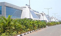
Karipur (also spelt Karippur) is a locality in the Kondotty taluk of the Malappuram district of Kerala, India, 25 km (16 mi) from the city of Malappuram. It is best known as the site of Karipur International Airport, serving travellers of mainly the South Malabar region. Other than that, it is a small hamlet that comes under the jurisdiction of Kondotty Municipality and Pallikkal gram panchayat. Karipur forms a portion of the Malappuram metropolitan area as of 2011 Census.[1]
Transportation[edit | edit source]
Karippur village connects to other parts of India through Kondotty town on the west and Nilambur town on the east. National highway No.66 passes through Pulikkal and the northern stretch connects to Goa and Mumbai. The southern stretch connects to Cochin and Trivandrum. State Highway No.28 starts from Nilambur and connects to Ooty, Mysore and Bangalore through Highways.12,29 and 181. Karipur International Airport is situated in this village. The nearest major railway stations are at Feroke(18 km away) and Parappanangadi(20 km away).
Schools[edit | edit source]
References[edit | edit source]
- ↑ "Constituents of Malappuram metropolitan area". kerala.gov.in.
External links[edit | edit source]
