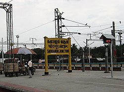
Shoranur
Shoranur | |
|---|---|
Town | |
 Shoranur Junction railway station, the largest railway station in the state in terms of area. | |
| Coordinates: 10°46′N 76°17′E / 10.77°N 76.28°ECoordinates: 10°46′N 76°17′E / 10.77°N 76.28°E | |
| Country | India |
| State | Kerala |
| District | Palakkad |
| Government | |
| • Body | Municipality |
| • Chairperson | M. K. Jayaprakash (Ward 29, CPM) |
| Area | |
| • Total | 32.28 km2 (12.46 sq mi) |
| Elevation | 49 m (161 ft) |
| Population (2011) | |
| • Total | 43,533 |
| • Density | 1,300/km2 (3,500/sq mi) |
| Languages | |
| • Official | Malayalam, English |
| Time zone | UTC+5:30 (IST) |
| PIN | 679121 |
| Telephone code | 0466 |
| Sex ratio | 1000:1096 ♂/♀ |
| Website | www |
Shoranur is a town and a municipality located in the Palakkad district, in the Indian state of Kerala, located on the banks of the Bharathapuzha River. The town covers an area of 32.28 km2.
Geography[edit]
Shoranur is located at 10°46′N 76°17′E / 10.77°N 76.28°E.[1] It has an average elevation of 49 metres (160 feet).
History[edit]
This place was originally a part of the Nedunganad Swaroopam dynasty, which was ruled by the Nedungadis, who sway over a large part of present-day Pattambi and Ottapalam Taluks.[2] By the end of the 15th century CE, Nedunganad came under the leadership of the Zamorin of Calicut, who was also the main ruler of South Malabar region.[2] The Zamorin appointed his local chieftain at Kavalappara Kovilakam to rule this area.[2] It was a part of Walluvanad Taluk in Malappuram Revenue Division of Malabar District during British Raj, with the Taluk headquarters at Perinthalmanna.[2]
Politics[edit]
Shornur became a municipality in 1978 and is divided into 33 electoral wards. It is a part of Shornur Legislative Assembly Constituency and Palakkad Parliamentary Constituency.[3] Shornur assembly constituency was formed in 2011. Before that Shornur municipality was under Pattambi assembly constituency.
Educational institutions[edit]
- Al Ameen Engineering College
- Jyoti engineering college, Cheruthuruthy
- Institute For Communicative And Cognitive Neurosciences, Kavalapara, Shoranur
- Vishnu Ayurveda College, Kulapully, Shoranur
- National Research Institute forPanchakarma, Cheruthuruthy
- Carmel School
- MPMMSN Trust College,Shoranur
Notable people[edit]
- Balan K. Nair, actor
- Meghanathan, actor
See also[edit]
References[edit]
- ↑ Falling Rain Genomics, Inc - Shoranur
- ↑ 2.0 2.1 2.2 2.3 Logan, William (2010). Malabar Manual (Volume-I). New Delhi: Asian Educational Services. pp. 631–666. ISBN 9788120604476.
- ↑ maps of india - shornur assembly constituency
