


m Bot: Delinking broken file(s) using script (info) |
expanded details based on references and corrected details |
||
| Line 1: | Line 1: | ||
{{short description|Regional divisions in | {{short description|Regional divisions in Haryana}} | ||
{{Multiple issues| | {{Multiple issues| | ||
{{Cleanup reorganize|date=October 2019}} | {{Cleanup reorganize|date=October 2019}} | ||
{{ | {{Too many sections|date=October 2019}} | ||
{{Expert needed|1= | {{Expert needed|1=India|reason=Many of the details of the article require a local resident or expert in the administration of the state of Haryana is required|date=October 2019}} | ||
{{More citations needed|date=October 2019}} | {{More citations needed|date=October 2019}} | ||
}} | }} | ||
{{Use dmy dates|date= | {{Use dmy dates|date=July 2025}} | ||
{{Use Indian English|date= | {{Use Indian English|date=July 2025}} | ||
[[File:Divisions of Haryana.png|thumb|Administrative Divisions of Haryana]] <!-- Update new map of 6 divisions. --> | [[File:Divisions of Haryana.png|thumb|Administrative Divisions of Haryana]] <!-- Update new map of 6 divisions. --> | ||
<!-- This article covers the '''administrative, ethnic, electoral, forests and wildlife, linguistic, political, etc zones, divisions and regions of Haryana'''. --> | <!-- This article covers the '''administrative, ethnic, electoral, forests and wildlife, linguistic, political, etc zones, divisions and regions of Haryana'''. --> | ||
[[Haryana]], formed on 1 November 1966, is a state in [[Northern Zonal Council|North India]]. For the administrative purpose, Haryana is divided into | [[Haryana]], formed on 1 November 1966, is a state in [[Northern Zonal Council|North India]]. For the administrative purpose, Haryana is divided into {{wikidata|qualifier|P31|P1114}} revenue divisions which are further divided into {{wikidata|qualifier|Q2668932|P360|P1114}} districts. For Law and Order maintenance, it is divided into 5 [[Police ranks and insignia of India#State police forces and their structure|Police Ranges]] and 4 [[Police ranks and insignia of India#State police forces and their structure|Police Commissionerates]].<ref name=harD1>[http://www.dailypioneer.com/state-editions/haryana-re-organises-administrative-units.html Reorganisation of Haryana divisions], Daily Pioneer, 3 January 2017.</ref><ref name=reddiv1>[http://www.uniindia.com/haryana-approves-to-create-two-new-revenue-divisions/states/news/768930.html Haryana approves to create two new revenue divisions], 2 February 2017.</ref><ref name=reddiv2>[https://timesofindia.indiatimes.com/city/chandigarh/authority-set-up-to-rejig-administrative-units-across-haryana/articleshow/56302722.cms Authority set up to rejig administrative units across Haryana], Times of India, 3 January 2017.</ref><ref name=reddiv3>[https://news.webindia123.com/news/articles/india/20170202/3048081.html Haryana approves to create two new revenue divisions] {{Webarchive|url=https://web.archive.org/web/20171229172256/https://news.webindia123.com/news/articles/india/20170202/3048081.html |date=29 December 2017 }}, Web India, 2 February 2017.</ref><ref name="Service">{{Cite web |last=Service |first=Tribune News |title=B Satheesh Balan appointed Commissioner of newly formed Sonepat Police Commissionerate |url=https://www.tribuneindia.com/news/haryana/b-satheesh-balan-appointed-commissioner-of-newly-formed-sonepat-police-commissionerate-466407 |access-date=2 January 2023 |website=Tribuneindia News Service |language=en}}</ref> | ||
==Administrative divisions== | ==Administrative divisions== | ||
| Line 17: | Line 17: | ||
===Civil administration and revenue divisions=== | ===Civil administration and revenue divisions=== | ||
{{anchor | Revenue divisions of Haryana | Revenue }} | {{anchor | Revenue divisions of Haryana | Revenue }} | ||
{{see also | List of districts of Haryana | History of Haryana#Districts | l2= History of districts of Haryana }} | |||
Administration of Haryana is divided into Revenue divisions composed of districts. Districts are further subdivided in to [[tehsil]]s of the revenue administration and the [[Community development block in India|Community development block]]s for the development work. | Administration of Haryana is divided into Revenue divisions composed of districts. Districts are further subdivided in to [[tehsil]]s of the revenue administration and the [[Community development block in India|Community development block]]s for the development work. | ||
Haryana has 6 administrative divisions, | Haryana has 6 administrative divisions, 23 [[List of districts of Haryana|districts]], 80 sub-divisions, 94 [[tehsil|revenue tehsil]]s, 50 sub-tehsils, 142 [[Community development block in India|community development block]]s, 154 [[List of cities in Haryana by population|cities and towns]], 7,030 villages and 6234 [[Gram panchayat|villages panchayats]].<ref name="harec1">{{cite web|title=Haryana State Budget 2017–18|url=http://web1.hry.nic.in/budget/Bgfinal.pdf|website=Haryana Finance Dept|access-date=7 October 2017|archive-date=22 August 2017|archive-url=https://web.archive.org/web/20170822065346/http://web1.hry.nic.in/budget/Bgfinal.pdf|url-status=dead}}</ref>{{Failed verification|date=September 2022|reason=No mention of division in the linked PDF file}} | ||
{|class="wikitable sortable" style="text-align: left;" | {|class="wikitable sortable" style="text-align: left;" | ||
| Line 32: | Line 33: | ||
| [[Gurugram division|Gurugram]] || [[Gurugram district|Gurugram]], [[Mahendragarh district|Mahendragarh]], [[Rewari district|Rewari]] | | [[Gurugram division|Gurugram]] || [[Gurugram district|Gurugram]], [[Mahendragarh district|Mahendragarh]], [[Rewari district|Rewari]] | ||
|- | |- | ||
| [[Hisar division|Hisar]] || [[Fatehabad district|Fatehabad]], [[Jind district|Jind]], [[Hisar district|Hisar]], [[Sirsa district|Sirsa]] | | [[Hisar division|Hisar]] || [[Fatehabad district|Fatehabad]], [[Jind district|Jind]], [[Hisar district|Hisar]], [[Sirsa district|Sirsa]] [[Hansi district|Hansi]] | ||
|- | |- | ||
| [[Rohtak division|Rohtak]] || [[Jhajjar district|Jhajjar]], [[Charkhi Dadri]], [[Rohtak district|Rohtak]], [[Sonipat district|Sonipat]], [[Bhiwani district|Bhiwani]] | | [[Rohtak division|Rohtak]] || [[Jhajjar district|Jhajjar]], [[Charkhi Dadri]], [[Rohtak district|Rohtak]], [[Sonipat district|Sonipat]], [[Bhiwani district|Bhiwani]] | ||
| Line 39: | Line 40: | ||
|} | |} | ||
==Engineering divisions == | == Engineering divisions == | ||
===Electricity distribution zones === | === Electricity distribution zones === | ||
[[Haryana Power Generation Corporation]] is responsible for producing and procuring power,<ref> | [[Haryana Power Generation Corporation]] is responsible for producing and procuring power,<ref>{{Cite web |url=http://hpgcl.gov.in/aboutus_1.hp |title=HPGCL |access-date=18 October 2019 |archive-date=7 April 2019 |archive-url=https://web.archive.org/web/20190407070116/http://www.hpgcl.gov.in/aboutus_1.hp |url-status=dead }}</ref><ref name=HGPCL1>{{Cite web |url=http://hpgcl.gov.in/powerplants_rpp.hp |title=HPGCL power plant capacity |access-date=18 October 2019 |archive-date=6 December 2017 |archive-url=https://web.archive.org/web/20171206005819/http://hpgcl.gov.in/powerplants_rpp.hp |url-status=dead }}</ref> and the following two [[Government of Haryana]] [[Public sector undertakings in India|PSU]]s are responsible for the distribution of electricity to the consumers and industries in the south and north zone, respectively: | ||
* [[Dakshin Haryana Bijli Vitran Nigam]], south zone distributor.<ref name=address>{{cite web |title=Address of various offices under DHBVN |url=http://www.dhbvn.com/main/contactus/address/addresses.htm |archive-url=https://web.archive.org/web/20120119080725/http://www.dhbvn.com/main/contactus/address/addresses.htm |url-status=dead |archive-date=19 January 2012 |publisher=DHBVN |access-date=10 July 2012 }}</ref><ref name="power">{{cite web|title=Dakshin Haryana Bijli Vitran Nigam(DHBVN) – Department of Power|url=http://dhbvn.org.in/web/portal/deptt.-of-power|website=dhbvn.org.in|access-date=14 December 2017}}</ref> | * [[Dakshin Haryana Bijli Vitran Nigam]], south zone distributor.HQ (OP) Hisar and Delhi.<ref name=address>{{cite web |title=Address of various offices under DHBVN |url=http://www.dhbvn.com/main/contactus/address/addresses.htm |archive-url=https://web.archive.org/web/20120119080725/http://www.dhbvn.com/main/contactus/address/addresses.htm |url-status=dead |archive-date=19 January 2012 |publisher=DHBVN |access-date=10 July 2012 }}</ref><ref name="power">{{cite web|title=Dakshin Haryana Bijli Vitran Nigam(DHBVN) – Department of Power|url=http://dhbvn.org.in/web/portal/deptt.-of-power|website=dhbvn.org.in|access-date=14 December 2017|archive-date=14 December 2017|archive-url=https://web.archive.org/web/20171214182609/http://dhbvn.org.in/web/portal/deptt.-of-power|url-status=dead}}</ref> | ||
* [[Uttar Haryana Bijli Vitran Nigam]], north zone distributor. | * [[Uttar Haryana Bijli Vitran Nigam]], north zone distributor.HQ(OP) Rohtak and Panchkula. | ||
===Irrigation commands === | === Irrigation commands === | ||
There are 6 command areas based on the systems of arterial supply canal and its | There are 6 command areas based on the systems of arterial supply canal and its end user branches and feeders. | ||
* Bhakra Canal Command: Fed by [[Sutlej]] river, controls [[Bhakra Dam#Irrigation|Bhakra Canal]] network within northern Haryana along Punjab border in the districts of Kaithal, northern Jind (Narwana), Sirsa, | * Bhakra Canal Command: Fed by [[Sutlej]] river, controls [[Bhakra Dam#Irrigation|Bhakra Canal]] network within northern Haryana along Punjab border in the districts of Kaithal, northern Jind (Narwana), Sirsa, Fatehabad, parts of Hisar (down to Hisar city). | ||
* Yamuna Canal Command: Fed by [[Western Yamuna Canal]], controls this network within northeastern, east and central Haryana in the districts of Karnal, Jind, Rohtak, Hansi-I area of Hisar, Tosham | * Yamuna Canal Command: Fed by [[Western Yamuna Canal]], controls this network within northeastern, east and central Haryana in the districts of Karnal, Jind, Rohtak, Hansi-I area of Hisar, Tosham, Bhiwani, Jhajjar, Sonepat, Panipat, and Karnal. | ||
* Siwani Canal Command: Fed by Western Yamuna Canal command, covers Siwani, Isharwal, Jhumpa areas of Bhiwani district. | * Siwani Canal Command: Fed by Western Yamuna Canal command, covers Siwani, Isharwal, Jhumpa areas of Bhiwani district. | ||
* Jui Canal Command: Fed by Western Yamuna Canal command, covers narrow tract of Kairu and Jui in Bhiwani district. | * Jui Canal Command: Fed by Western Yamuna Canal command, covers narrow tract of Kairu and Jui in Bhiwani district. | ||
| Line 62: | Line 63: | ||
===Police commissionerates=== | ===Police commissionerates=== | ||
Police commissionerates of Haryana, total | Police commissionerates of Haryana, total 5 in number, are as follows (c. January 2024):<ref>{{Cite web |title=Sonipat News: गुरुग्राम, फरीदाबाद और पंचकूला के बाद चौथा पुलिस कमिश्नरेट होगा सोनीपत |url=https://www.jagran.com/haryana/sonipat-ncr-sonipat-will-be-the-fourth-police-commissionerate-after-gurugram-faridabad-and-panchkula-23178618.html |access-date=2 January 2023 |website=Dainik Jagran |language=hi}}</ref><ref>{{Cite web |date=1 January 2023 |title=Sonepat Police Commissionerate to start functioning from today |url=https://www.hindustantimes.com/cities/chandigarh-news/sonepat-police-commissionerate-to-start-functioning-from-today-101672515459474.html |access-date=2 January 2023 |website=Hindustan Times |language=en}}</ref><ref name="Service"/> | ||
{|class="wikitable sortable" style="text-align: left;" | {|class="wikitable sortable" style="text-align: left;" | ||
| Line 73: | Line 74: | ||
|- | |- | ||
| [[Panchkula|Panchkula Commissionerate]] || [[Panchkula]] | | [[Panchkula|Panchkula Commissionerate]] || [[Panchkula]] | ||
|- | |||
| [[Sonipat|Sonipat Commissionerate]] || [[Sonipat]] | |||
|- | |||
|[[Jhajjar|Jhajjar Commissionerate]] || [[Jhajjar]] | |||
|} | |} | ||
| Line 102: | Line 107: | ||
|- | |- | ||
|Sirsa | |Sirsa | ||
|- Mandi Dabwali (Police District) | |||
|- | |- | ||
|Jind | |Jind | ||
| Line 123: | Line 129: | ||
|Nuh | |Nuh | ||
|- | |- | ||
| rowspan=" | | rowspan="4" |5 | ||
| rowspan=" | | rowspan="4" |Rohtak | ||
|Rohtak | |Rohtak | ||
|- | |- | ||
|Jhajjar | |Jhajjar | ||
|- | |||
|Bhiwani | |||
|- | |- | ||
|Sonipat | |Sonipat | ||
|- | |- | ||
|Charkhi Dadri | |Charkhi Dadri | ||
|} | |} | ||
===Prisons=== | |||
See [[list of prisons in Haryana]]. | |||
{{anchor | Police ranges of Haryana | Ranges }} | |||
==Electoral divisions== | ==Electoral divisions== | ||
| Line 140: | Line 151: | ||
===Lok Sabha=== | ===Lok Sabha=== | ||
[[File:Haryana_Wahlkreise_Lok_Sabha.svg | thumb|240px | right |Lok Sabha constituencies in Haryana. Reserved constituencies in yellow.]] | [[File:Haryana_Wahlkreise_Lok_Sabha.svg|thumb|240px | right |Lok Sabha constituencies in Haryana. Reserved constituencies in yellow.]] | ||
For electing the national-level [[Government of India]], there are 10 [[Lok Sabha]] constituencies in Haryana. [[Elections in Haryana#Lok Sabha elections|Current Lok Sabha constituencies]] in Haryana are: | For electing the national-level [[Government of India]], there are 10 [[Lok Sabha]] constituencies in Haryana. [[Elections in Haryana#Lok Sabha elections|Current Lok Sabha constituencies]] in Haryana are: [[Ambala (Lok Sabha constituency)|Ambala]], [[Bhiwani–Mahendragarh (Lok Sabha constituency)|Bhiwani–Mahendragarh]], [[Faridabad (Lok Sabha constituency)|Faridabad]], [[Gurugram (Lok Sabha constituency)|Gurgaon]], [[Hisar (Lok Sabha constituency)|Hisar]], [[Karnal (Lok Sabha constituency)|Karnal]], [[Kurukshetra (Lok Sabha constituency)|Kurukshetra]], [[Rohtak (Lok Sabha constituency)|Rohtak]], [[Sirsa (Lok Sabha constituency)|Sirsa]], and [[Sonipat (Lok Sabha constituency)|Sonipat]]. | ||
[[Ambala (Lok Sabha constituency)|Ambala]], | |||
[[Bhiwani–Mahendragarh (Lok Sabha constituency)|Bhiwani–Mahendragarh]], | |||
[[Faridabad (Lok Sabha constituency)|Faridabad]], | |||
[[ | |||
[[Hisar (Lok Sabha constituency)|Hisar]], | |||
[[Karnal (Lok Sabha constituency)|Karnal]], | |||
[[Kurukshetra (Lok Sabha constituency)|Kurukshetra]], | |||
[[Rohtak (Lok Sabha constituency)|Rohtak]], | |||
[[Sirsa (Lok Sabha constituency)|Sirsa]], and | |||
[[Sonipat (Lok Sabha constituency)|Sonipat]]. | |||
===Vidhan sabha=== | ===Vidhan sabha=== | ||
[[File:Wahlkreise_zur_Vidhan_Sabha_von_Haryana.svg|thumb|right|240px|Haryana Vidhan Sabha constituencies, reserved constituencies in yellow.]] | [[File:Wahlkreise_zur_Vidhan_Sabha_von_Haryana.svg|thumb|right|240px|Haryana Vidhan Sabha constituencies, reserved constituencies in yellow.]] | ||
{{Main|List of constituencies of the Haryana Legislative Assembly|l1 = }} | {{Main|List of constituencies of the Haryana Legislative Assembly|l1 = }} | ||
For electing the state-level [[Government of Haryana]], there are 90 | For electing the state-level [[Government of Haryana]], there are 90 Vidhan Sabha constituencies of [[Haryana Legislative Assembly]], of which 17 are [[Reserved political positions in India|reserved constituencies for the scheduled castes]]. | ||
==Forests and wildlife divisions== | ==Forests and wildlife divisions== | ||
| Line 166: | Line 167: | ||
There are 2 Forests Protections zone and 4 Forests circles/divisions, i.e. 2 circles per zone.<ref name=fork1>[http://haryanaforest.gov.in/Portals/0/hfs-mannual-25-5-2015.pdf Haryana Forests Manual]</ref> | There are 2 Forests Protections zone and 4 Forests circles/divisions, i.e. 2 circles per zone.<ref name=fork1>[http://haryanaforest.gov.in/Portals/0/hfs-mannual-25-5-2015.pdf Haryana Forests Manual]</ref> | ||
* Forests Protection zone-1: Panchkula, covers geographical northern half of Haryana.<ref name=fork1/> It consists of North Forests Circle/Division which covers northeast geographical quadrant of Haryana including Shivalik Hills and down to Sonipat | * Forests Protection zone-1: Panchkula, covers geographical northern half of Haryana.<ref name=fork1/> It consists of North Forests Circle/Division which covers northeast geographical quadrant of Haryana including Shivalik Hills and down to Sonipat<ref name="fork1" /> and West Forests Circle/Division which Covers northwest geographical quadrant of Haryana including Sirsa, Hisar, Jind.<ref name="fork1" /> | ||
* Forests Protection zone-2: Based at Gurugram, covers geographical southern half of Haryana.<ref name=fork1/> It consists of Central Forests Circle/Division which covers central geographical quadrant of Haryana including Rohtak, Jhajjar, Charkhi Dadri, Bhiwani, Mahendragarh etc.<ref name="fork1" /> and South Forests Circle/Division which covers geographical South Haryana including Faridabad, Nuh, Palwal, etc.<ref name="fork1" /> | * Forests Protection zone-2: Based at Gurugram, covers geographical southern half of Haryana.<ref name=fork1/> It consists of Central Forests Circle/Division which covers central geographical quadrant of Haryana including Rohtak, Jhajjar, Charkhi Dadri, Bhiwani, Mahendragarh etc.<ref name="fork1" /> and South Forests Circle/Division which covers geographical South Haryana including Faridabad, Nuh, Palwal, etc.<ref name="fork1" /> | ||
| Line 175: | Line 176: | ||
* Wildlife South zone: Based at Gurugram, covers geographical southern half of Haryana including Charkhi Dadri, Bhiwani, Mahendragarh, Nuh, palwal, Gurugram, Faridabad, etc.<ref name=fork1/> | * Wildlife South zone: Based at Gurugram, covers geographical southern half of Haryana including Charkhi Dadri, Bhiwani, Mahendragarh, Nuh, palwal, Gurugram, Faridabad, etc.<ref name=fork1/> | ||
; Wildlife | ; [[Wildlife corridor]]s | ||
* [[Aravalli Range#Northern Aravalli leopard and wildlife corridor|Sariska-Delhi leopard corridor]] | * [[Aravalli Range#Northern Aravalli leopard and wildlife corridor|Sariska-Delhi leopard corridor]] | ||
* Sahibi wildlife corridor (planned) | * Sahibi wildlife corridor (planned) | ||
| Line 201: | Line 202: | ||
''GT Road belt'' is the geographical area on either side of the [[Grand Trunk Road]] from Delhi to Ambala. Upland areas around Indri north of Karnal is called [[Nardak]]. The road itself lies inside the unflooded Bangar area roughly along the demarcation between Yamuna bangar and Yamuna Khadir. GT Road is a new term for the ancient vedic era route which was later rehabilitated by [[Ashoka]] (268 to 232 BCE), [[Harsha]] (c. 590–647 CE), and [[Sher Shah Suri]] (1486 – 22 May 1545), etc. | ''GT Road belt'' is the geographical area on either side of the [[Grand Trunk Road]] from Delhi to Ambala. Upland areas around Indri north of Karnal is called [[Nardak]]. The road itself lies inside the unflooded Bangar area roughly along the demarcation between Yamuna bangar and Yamuna Khadir. GT Road is a new term for the ancient vedic era route which was later rehabilitated by [[Ashoka]] (268 to 232 BCE), [[Harsha]] (c. 590–647 CE), and [[Sher Shah Suri]] (1486 – 22 May 1545), etc. | ||
====Yamuna Bangar ==== | ==== Yamuna Bangar ==== | ||
{{anchor | Deshwal | {{anchor | Deshwal | Deshwali | Yamuna bangar | Yamuna Bangar }} | ||
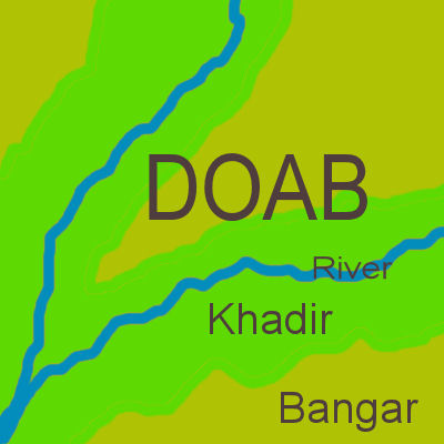
[[File:Khadir-and-bangar.jpg|thumb|240px|In a [[doab]], ''khadar'' (green) floodplain lies next to a river, unflooded ''bangar'' (olive) with higher elevation lies further from river.]] | [[File:Khadir-and-bangar.jpg|thumb|240px|In a [[doab]], ''khadar'' (green) floodplain lies next to a river, unflooded ''bangar'' (olive) with higher elevation lies further from river.]] | ||
| Line 213: | Line 214: | ||
=====Nardak===== | =====Nardak===== | ||
''Nardak'' ("high tract" or bangar) is a region in western and northern parts of [[Karnal district]] in northeastern area of [[Haryana]] state of India. All definitions of this area include [[Assandh]], [[Nissing]] and [[Nilokheri]] [[Community Development Block]]s (CDB) in western and northern parts of [[Karnal district]], and it ends in the north of Karnal city at [[Indri]] where Nardak, [[Khadir and Bangar]] areas of [[Yamuna]] river basin meet.<ref name=wolv1>K. K. Aggarwal, 1975, [https://books.google.com | ''Nardak'' ("high tract" or bangar) is a region in western and northern parts of [[Karnal district]] in northeastern area of [[Haryana]] state of India. All definitions of this area include [[Assandh]], [[Nissing]] and [[Nilokheri]] [[Community Development Block]]s (CDB) in western and northern parts of [[Karnal district]], and it ends in the north of Karnal city at [[Indri]] where Nardak, [[Khadir and Bangar]] areas of [[Yamuna]] river basin meet.<ref name=wolv1>K. K. Aggarwal, 1975, [https://books.google.com/books?id=W187AAAAMAAJ&q=Nardak Karnal District], page 2.</ref> ''Nardak'' is a title of the [[Kurukshetra]] from the words ''"Nirdukh"'', meaning the ''"painless"''.<ref name=nard1>1890, Calcutta Review, Volumes 90-91, Page 108.</ref> Nardak is the high tract, hence a sub-region of [[Khadir and Bangar|bangar]] (unflooded) region of Yamuna river. | ||
During the [[Vedic era]], it | During the [[Vedic era]], it was part of [[Kuru Kingdom|Kuru]] [[janapada]], hence presently has many ''[[Mahabharata]]'' era [[Tirtha (Hinduism)|tirthas]] which are part of the wider [[48 Kos Parikrama of Kurukshetra]]. Presently, Nardak area lies on either side of [[Grand Trunk Road]]. | ||
====Yamuna Khadir==== | ====Yamuna Khadir==== | ||
[[Khadir and Bangar|Khadir]] (खादर) is any low-lying [[floodplain]]s of a river usually relatively narrower compared to unflooded ''bangar'' area. Khadar areas are prone to flooding and sometimes include [[Palaeochannel|portions of former river-bed]]s that became available for agriculture when a [[Avulsion (river)|river changes course]]. It is moisture retentive and sticky when wet.<ref name="ref07rejic">{{Citation | title=भूगोल (Geography) | author=Yash Pal Singh | year=1920 | publisher=VK Publications | isbn=978-81-89611-21-7 | url=https://books.google.com/books?id=dzSfcInDKD8C | quote=''... मैदान के उस भाग को बांगर कहते हैं जहाँ नदियों की बाढ़ का पानी नहीं पहुंच पाता ... पुरानी जलोढ़ मिट्टी ... खादर: यह वह क्षेत्र है जहाँ नदियों की बाढ़ का जल प्रतिवर्ष आ जाता है ...''}}</ref><ref name=allsoil1/> ''Khadir'' soil consists of new [[alluvial soil]] relatively higher in new [[silt]] content from the river, gets replenished with each flooding cycle, and is often very fertile.<ref name=allsoil1>Kiran Prem,1994, [https://books.google.com/books?id=wjhuAAAAMAAJ Haryana District Gazetteers: Faridabad], Haryana, Page 16.</ref> Haryana has two such floodplains, Yamuna Khadir and Nali. | [[Khadir and Bangar|Khadir]] (खादर) is any low-lying [[floodplain]]s of a river usually relatively narrower compared to unflooded ''bangar'' area. Khadar areas are prone to flooding and sometimes include [[Palaeochannel|portions of former river-bed]]s that became available for agriculture when a [[Avulsion (river)|river changes course]]. It is moisture retentive and sticky when wet.<ref name="ref07rejic">{{Citation | title=भूगोल (Geography) | author=Yash Pal Singh | year=1920 | publisher=VK Publications | isbn=978-81-89611-21-7 | url=https://books.google.com/books?id=dzSfcInDKD8C | quote=''... मैदान के उस भाग को बांगर कहते हैं जहाँ नदियों की बाढ़ का पानी नहीं पहुंच पाता ... पुरानी जलोढ़ मिट्टी ... खादर: यह वह क्षेत्र है जहाँ नदियों की बाढ़ का जल प्रतिवर्ष आ जाता है ...''}}</ref><ref name=allsoil1/> ''Khadir'' soil consists of new [[alluvial soil]] relatively higher in new [[silt]] content from the river, gets replenished with each flooding cycle, and is often very fertile.<ref name=allsoil1>Kiran Prem,1994, [https://books.google.com/books?id=wjhuAAAAMAAJ Haryana District Gazetteers: Faridabad], Haryana, Page 16.</ref> Haryana has two such floodplains, Yamuna Khadir and Nali. | ||
Yamuna Khadir, or simply ''Khadir'', is a fertile floodland area lying between the Yamuna river and the [[Grand Trunk Road]], i.e. eastern parts of Sonepat, Panipat, Karnal and Kurukshetra as well as southeastern Yamunanagr district. | Yamuna Khadir, or simply ''Khadir'', is a fertile floodland area lying between the Yamuna river and the [[Grand Trunk Road]], i.e. eastern parts of Sonepat, Panipat, Karnal and Kurukshetra as well as southeastern Yamunanagr district. | ||
===Aravalli in South Haryana: Ahirwal, Braj and Mewat === | === Aravalli in South Haryana: Ahirwal, Braj and Mewat === | ||
Areas of Haryana lying in [[Aravalli Range|Aravalli]] hills range mostly fall within [[Ahirwal]] and [[Mewat]] regions. | Areas of Haryana lying in [[Aravalli Range|Aravalli]] hills range mostly fall within [[Ahirwal]] and [[Mewat]] regions. | ||
* [[Vedic era|Vedia]] era [[janapada]] regions are: | * [[Vedic era|Vedia]] era [[janapada]] regions are: | ||
** [[Braj]] includes | ** [[Braj]] includes [[Palwal]] district and [[Faridabad]] district. 84 kos Braj Mandal Parikrama also passes by many villages in Palwal district. This Parikrama starts from [[Banchari]]. | ||
** [[Kuru Kingdom|Kuru]] including Gurugram and Faridabad, Palwal in Aravali area. Kuru also extended along Yamuna to Kurukshetra. | ** [[Kuru Kingdom|Kuru]] including Gurugram and Faridabad, Palwal in Aravali area. Kuru also extended along Yamuna to Kurukshetra. | ||
** [[Matsya | ** [[Matsya (tribe)|Matsya]] Narnaul, Rewari, Mahendergarh, Kanina, Nuh, etc. which also corresponds with the present day Ahirawal and Mewat regions. | ||
* Pre-Islamic Hindu-[[Rajput]] era regions: <br>These areas were part of [[Alwar State|Alwar kingdom]] ruled by [[Kachhwaha]] [[Rajput]]s | * Pre-Islamic Hindu-[[Rajput]] era regions: <br/>These areas were part of [[Alwar State|Alwar kingdom]] ruled by [[Kachhwaha]] [[Rajput]]s who claim descent from [[Kusha]] - the eldest son of [[Rama]]. These areas were adjacent [[Dhundhar]], also called [[Jaipur]] region under [[Jaipur State|Jaipur kingdom]], to Dhundhar's the east and northeast side. | ||
** [[Bighoto]]: Historic region which covered present day districts of Rewari and Mahendragarh. | ** [[Bighoto]]: Historic region which covered present day districts of Rewari and Mahendragarh. | ||
** [[Bighoto#Chandain|Chandain]]: Historic region, | ** [[Bighoto#Chandain|Chandain]]: Historic region, which covered 12 villages of Taoru, was a subdivision of the bigger Bighoto region, which in turn was part of [[Alwar State]]. This region overlaps with and also lies entirely within Mewat. | ||
** [[Dhundhoti]]: Historic region which covered present day districts of Gurugram has its seat of power at [[Garhi Harsaru]]. | ** [[Dhundhoti]]: Historic region which covered present day districts of Gurugram has its seat of power at [[Garhi Harsaru]]. | ||
* Medieval and present day regions: | * Medieval and present day regions: | ||
** [[Ahirwal]]: [[Ahir]] dominated areas such as Narnaul, Rewari and parts of Faridabad district | ** [[Ahirwal]]: [[Ahir]] dominated areas such as Narnaul, Rewari, Kanina, Mahendergarh and parts of Faridabad district | ||
** [[Mewat]]: narrow tract in Haryana in [[Nuh district]] from Nuh city ion the north to [[Ferozepur Jhirka]] in the south and till [[Ujina]] and [[Uttawar]] in the east. Mewat, [[Meo (ethnic group)|Meo]]-dominated area, covers much larger area which spans the contiguous area in Rajasthan. | ** [[Mewat]]: narrow tract in Haryana in [[Nuh district]] from Nuh city ion the north to [[Ferozepur Jhirka]] in the south and till [[Ujina]] and [[Uttawar]] in the east. Mewat, [[Meo (ethnic group)|Meo]]-dominated area, covers much larger area which spans the contiguous area in Rajasthan. | ||
===Bagar | === Bagar Region or Westen Haryana === | ||
{{anchor | Bagar | West | Western }} | |||
[[Bagar | [[Bagar region]] or ''Bagad'' (''बागड़''), from "''Bar"'' meaning the dry country,<ref name=bagartribune1>Nonica Datta, [http://www.tribuneindia.com/1999/99jul03/saturday/head1.htm "Forming an identity"], [[The Tribune (Chandigarh)|The Tribune]], 3 July 1999.</ref> refers to the area where [[Bagri language]] is spoken by majority of population characterised by sandy tract of north-western [[India]] and eastern [[Pakistan]] bordering [[Rajasthan]], [[India]] which are now transformated into fertile tracts, irrigated by Bhakhra canal, [[Indira Gandhi Canal]], [[Gang canal]] in India.<ref name="HarRev">{{Cite web |url=http://revenueharyana.gov.in/html/gazeteers/revised_settlement_hisar.pdf |title=Revised Land and Revenue Settlement of Hisar District 9006–9011 |access-date=26 March 2016 |archive-url=https://web.archive.org/web/20170517124050/http://revenueharyana.gov.in/html/gazeteers/revised_settlement_hisar.pdf |archive-date=17 May 2017 |url-status=dead }}</ref> In Haryana, it covers [[Sirsa district]] and western villages of [[Fatehabad, Haryana|Fatehabad]], [[Hisar district]], [[Bhiwani district]] and [[Charkhi Dadri district]].<ref name="GL1">Gusain, Lakhan: Reflexives in Bagri. Jawaharlal Nehru University, New Delhi, 1994</ref><ref name="GL2">Gusain, Lakhan: Limitations of Literacy in Bagri. [[Nicholas Ostler]] & [[Blair Rudes]] (eds.). Endangered Languages and Literacy. Proceedings of the Fourth FEL Conference. University of North Carolina, Charlotte, 21–24 September 2000</ref> in [[Rajasthan]] it covers [[Anupgarh district]], [[Sri Ganganagar district]]; [[Hanumangarh district]]; [[Taranagar]] tehsil in [[Churu district]].<ref name="GL1" /><ref name="Census1961">[https://archive.org/stream/districtcensusha01indi/districtcensusha01indi_djvu.txt India District Census Handbook, 1961]</ref> [[Chak (village)|Chak]], type of villages, were established in the northern part of this tract along the canal network during [[British Raj]]. Smaller settlements in the farms are called [[dhani (settlement type)|dhani]]. | ||
===Sarasvati-Ghaggar-Chautang basin in north === | === Sarasvati-Ghaggar-Chautang basin in north === | ||
This area lies in the Ghaggar-Chautang [[doab]] in northwestern Haryana bounded by Narvana, Hansi, Hisar, and | This area lies in the Ghaggar-Chautang [[doab]] in northwestern Haryana bounded by Narvana, Hansi, Hisar and Ellenabad. It is considered as one of the most productive farmland areas in Haryana with a high yield of wheat, rice, mustard, kinnow, green leafy vegetables and cotton especially. | ||
====Sarasvati-Ghaggar basin==== | ====Sarasvati-Ghaggar basin==== | ||
Bangar | Bangar remains unflooded, while Nali (also called Khadir) becomes flooded during the rainy season. | ||
=====Sarasvati-Ghaggar bangar===== | =====Sarasvati-Ghaggar bangar===== | ||
These are areas along either side of Ghaggar | These are areas along either side of Ghaggar that do not get flooded. They lie in the district of Jind (Narwana), Fatehabad, north Hisar and Sirsa. This basin has numerous [[Indus Valley civilization|Sarasvati-Indus Valley civilisation]] sites. | ||
=====Nali khadir or Ghaggar khadir ===== | ===== Nali khadir or Ghaggar khadir ===== | ||
Nali area, or simply ''Nali'' (नाळी), is the fertile floodland Khadir area in Fatehabad and Sirsa districts between the [[Ghaggar-Hakra River|Ghaggar]] river and the southern limits of the [[Drishadvati river|Saraswati palaeochannel depression]] that gets flooded during the rains.<ref name="nali1">[https://archive.org/stream/imperialgazettee14grea/imperialgazettee14grea_djvu.txt "The imperial gazetteers of India, 1908"], [[British Raj]], page 288.</ref> Parts of this also lie in Narwana (north Jind region). [[Kunal, Haryana|Kunal]] is an important Sarasvati-Indus Valley | Nali area, or simply ''Nali'' (नाळी), is the fertile floodland Khadir area in Fatehabad and Sirsa districts between the [[Ghaggar-Hakra River|Ghaggar]] river and the southern limits of the [[Drishadvati river|Saraswati palaeochannel depression]] that gets flooded during the rains.<ref name="nali1">[https://archive.org/stream/imperialgazettee14grea/imperialgazettee14grea_djvu.txt "The imperial gazetteers of India, 1908"], [[British Raj]], page 288.</ref> It includes areas such as Sardulgarh on Punjab-Haryana Border, Rori, Mirpur, Panniwala Motta, Rania, Jiwan Nagar and Ellenabad in Sirsa District and Tibi of adjacent Tibi tehsil in Hanumangarh District of Rajasthan. Parts of this also lie in Narwana (north Jind region). [[Kunal, Haryana|Kunal]] is an important Sarasvati-Indus Valley civilisation site on the paleo bank of Sarasvati (Ghaggar) river. | ||
====Drishadvati-Chautang basin==== | ====Drishadvati-Chautang basin==== | ||
| Line 262: | Line 264: | ||
This area lies in the Ghaggar-Chautang [[doab]] in northwestern Haryana. | This area lies in the Ghaggar-Chautang [[doab]] in northwestern Haryana. | ||
=====Chautang bangar ===== | ===== Chautang bangar ===== | ||
The area which get flooded along and either side of Chautang include area in the tehsils of Jind, Hansi, Hisar, [[Bawani Khera]], [[Siwani]], | The area which get flooded along and either side of Chautang include area in the tehsils of Jind, Hansi, Hisar, [[Bawani Khera]], [[Siwani]], | ||
=====Chautang khadir ===== | ===== Chautang khadir ===== | ||
The area which get flooded along Chautang include low lying areas of Jind, Hansi, Hisar. This is the paleo channel of Drishadvati. The Sarasvati-Indus Valley | The area which get flooded along Chautang include low lying areas of Jind, Hansi, Hisar. This is the paleo channel of Drishadvati. The Sarasvati-Indus Valley civilisation sites on the paleo channel of Drishadvati are [[Rakhigarhi]], [[Lohari Ragho]], [[Banawali]] and [[Sothi (archaeology)|Sothi]] which lies in the western Haryana districts of Hisar, Fatehabad and Sirsa. | ||
==Industrial zones and corridors== | ==Industrial zones and corridors== | ||
[[Haryana State Industrial and Infrastructure Development Corporation|HSIIDC]] has developed at least 11 specialised ''"Industrial Clusters and Theme Parks"'', 24 ''"Industrial Estate (IE)"'' (each | [[Haryana State Industrial and Infrastructure Development Corporation|HSIIDC]] has developed at least 11 specialised ''"Industrial Clusters and Theme Parks"'', 24 ''"Industrial Estate (IE)"'' (each with an area larger than at least {{cvt|610|ha}}), ''"Industrial Model Township (IMT)"'' (smaller than {{cvt|610|ha}}), and an IT Park (denoted by double asterisk or star symbol). Haryana has at least 24 IEs, 7 IMT, an IT Park, and several [[Haryana State Industrial and Infrastructure Development Corporation#Integrated Multimodel Logistics Hubs (IMLH)|Integrated Multimodel Logistics Hubs]] (IMLH) in the state of Haryana.<ref name=theme1>[https://hsiidc.org.in/industrial-cluster HSIIDC Industrial Clusters and Theme Parks] {{Webarchive|url=https://web.archive.org/web/20191018105825/https://hsiidc.org.in/industrial-cluster |date=18 October 2019 }}.</ref><ref name=about2>[https://hsiidc.org.in/industrial-estates HSIIDC branches and estates] {{Webarchive|url=https://web.archive.org/web/20191018105824/https://hsiidc.org.in/industrial-estates |date=18 October 2019 }}.</ref> | ||
; [[Industrial corridor# | ; [[Industrial corridor#India|Industrial corridors]] | ||
{{div col|colwidth=20em}} | {{div col|colwidth=20em}} | ||
* [[Amritsar Delhi Kolkata Industrial Corridor]] | * [[Amritsar Delhi Kolkata Industrial Corridor]] | ||
| Line 300: | Line 302: | ||
[[File:Punjabdoabs1.jpg|thumb|200px|A map of the Punjab region {{circa}} 1947 showing the different ''doabs''.]] | [[File:Punjabdoabs1.jpg|thumb|200px|A map of the Punjab region {{circa}} 1947 showing the different ''doabs''.]] | ||
[[Doab]] ([[interfluve]]) is land lying between two [[confluence|confluent]] rivers<ref name=oed-doab-cite-1>{{citation|title=doab or duab, n.|publisher=OED Online, Oxford University Press |date=March 2014|url=http://www.oed.com/view/Entry/56229|access-date=24 April 2019}} Quote: "Originally and chiefly in South Asia: (the name of) a strip or narrow tract of land between two rivers; spec. (with) the area between the rivers Ganges and Jumna in northern India."</ref><ref name=oed-doab-cite-2>{{citation|title=doab or duab, n.|publisher=OED Online, Oxford University Press |date=March 2014|url=http://www.oed.com/view/Entry/56229|access-date=24 April 2019}} Quote: "confluence, land between two rivers, used in India of the tongue of land between the Ganges and Jumna, and of similar tracts in the Punjab, etc., lit. 'two waters' "</ref><ref name=doab-websters-unabridge>{{citation|title=Doab.|publisher=Webster's Third New International Dictionary, Unabridged.|year=2013|url=http://www.merriam-websterunabridged.com/unabridged/doab|access-date=24 April 2019}} Quote: " a tract of land between two rivers : | [[Doab]] ([[interfluve]]) is land lying between two [[confluence|confluent]] rivers<ref name=oed-doab-cite-1>{{citation|title=doab or duab, n.|publisher=OED Online, Oxford University Press |date=March 2014|url=http://www.oed.com/view/Entry/56229|access-date=24 April 2019}} Quote: "Originally and chiefly in South Asia: (the name of) a strip or narrow tract of land between two rivers; spec. (with) the area between the rivers Ganges and Jumna in northern India."</ref><ref name=oed-doab-cite-2>{{citation|title=doab or duab, n.|publisher=OED Online, Oxford University Press |date=March 2014|url=http://www.oed.com/view/Entry/56229|access-date=24 April 2019}} Quote: "confluence, land between two rivers, used in India of the tongue of land between the Ganges and Jumna, and of similar tracts in the Punjab, etc., lit. 'two waters' "</ref><ref name=doab-websters-unabridge>{{citation|title=Doab.|publisher=Webster's Third New International Dictionary, Unabridged.|year=2013|url=http://www.merriam-websterunabridged.com/unabridged/doab|access-date=24 April 2019}} Quote: " a tract of land between two rivers : interfluve"</ref> | ||
===Extant doab=== | ===Extant doab=== | ||
| Line 308: | Line 310: | ||
===Palaeo doab=== | ===Palaeo doab=== | ||
*'''Sarasvati-Yamuna doab / Ghaggar-Yamuna doab''': Almost all of the northern border of Haryana is roughly defined by the course of present-day seasonal [[Sarsuti]] river, which is one of many [[Palaeochannel]] of [[Sarasvati river]]. It is now the tributary of present-day [[Ghaggar-Hakra River|Ghaggar river]], which is currently the most | *'''Sarasvati-Yamuna doab / Ghaggar-Yamuna doab''': Almost all of the northern border of Haryana is roughly defined by the course of present-day seasonal [[Sarsuti]] river, which is one of many [[Palaeochannel]] of [[Sarasvati river]]. It is now the tributary of present-day [[Ghaggar-Hakra River|Ghaggar river]], which is currently the most voluminous or main ramnant channel of Sarasvati river. Almost all of the eastern border of Haryana is roughly defined by the course of [[Yamuna]] river. Area between the ancient Sarasvati (with its several palaeochannel in Haryana, including Sarsuti and Ghaggar, and the largest [[Paleolithic|paleo]] tributary Dhrisdhavati) and Yamuna is called the ''Sarasvati-Yamuna doab''. According to the paleo studies, the earliest paleo channel of Sarasvati flowed southeast collecting [[Sahibi|Sahibi river]] and converging with Yamuna. This ''Sarasvati-Yamuna doab'' covered the area of districts of Panchkula, Ambala, Yamunanagr, Kurukshetra, Kaithal, parts of Jind, Karnal, Panipat, Sonepat, Rohtak, Jhajjar and Gurugram. It remains a matter of further study if Sarasvati ever confluenced with [[Ganges]]-Yamuna at [[Prayagraj]] as alluded to in the [[Hindu texts]], if this hypothesis if found to be true, Sarasvati would have also flowed through Rwari, Fridabad and Nuh districts of Haryana and would have collected [[Chambal River|Chambal]] and [[Betwa River|Betwa]] rivers as its tributaries. Since Sarasvati and Yamuna no longer confluence, this palaeo Sarasvati-Yamuna doab no longer exists. Only extant doab in Haryana is ''Sarsuti-Ghaggar doab''. Palaeo Sarasvati-Yamuna doab could be subdivided into the following doabs of ''Drishadvati-Sahibi doab'', ''Drishadvati-Sahibi doab'' and ''Sahibi-Yamuna doab''. | ||
*'''Sarasvati-[[Drishadvati river|Drishadvati]] doab''' / '''Ghaggar-[[Drishadvati river|Drishadvati]] doab''': This palaeo doab covered the area lying between Ghaggar river (palaeochannel of Sarasvati) and the palaeochannel Drishadvati river which confluenced in Hanumangarh district immediately northwest of Haryana. This doab area included entire Northern Haryana on Haryana-Punjab, i.e. districts of Panchkula, Ambala, Yamunanagar, Kurukshetra, Kaithal, Jind, northern part of Hisar, Fatehabad and Sisra. | *'''Sarasvati-[[Drishadvati river|Drishadvati]] doab''' / '''Ghaggar-[[Drishadvati river|Drishadvati]] doab''': This palaeo doab covered the area lying between Ghaggar river (palaeochannel of Sarasvati) and the palaeochannel Drishadvati river which confluenced in Hanumangarh district immediately northwest of Haryana. This doab area included entire Northern Haryana on Haryana-Punjab, i.e. districts of Panchkula, Ambala, Yamunanagar, Kurukshetra, Kaithal, Jind, northern part of Hisar, Fatehabad and Sisra. | ||
*'''Drishadvati-[[Sahibi River|Sahibi]] doab''' / '''Ghaggar-Sahibi doab''': This palaeo doab covered the area of northwestern Haryana, i.e. districts of Sirsa, Fatehabad, Hisar, Bhiwani, Charkhi Dadri and Mahendragarh. | *'''Drishadvati-[[Sahibi River|Sahibi]] doab''' / '''Ghaggar-Sahibi doab''': This palaeo doab covered the area of northwestern Haryana, i.e. districts of Sirsa, Fatehabad, Hisar, Bhiwani, Charkhi Dadri and Mahendragarh. | ||
| Line 314: | Line 316: | ||
==Language zones== | ==Language zones== | ||
* [[Hindi languages|Hindi (Central Zone)]] | * [[Hindi languages|Hindi (Central Zone)]] | ||
** [[Haryanvi language]] | ** [[Haryanvi language]] | ||
*** [[Deswali (dialect)]] (also called ''Deshwali'', ''Desari'' and ''Desaru'', spoken in Deswal region covering districts of Rohtak, Sonipat and Jhajjar. | *** [[Deswali (dialect)]](also called ''Deshwali'', ''Desari'' and ''Desaru'', spoken in Deswal region covering districts of Rohtak, Sonipat and Jhajjar. | ||
*** [[Standard Haryanvi (dialect)]] spoken in Jind, Hisar, Hansi, Bhiwani, Tosham, Charki Dadri, Meham | *** [[Standard Haryanvi (dialect)]] spoken in Jind, Hisar, Hansi, Bhiwani, Tosham, Charki Dadri, Meham. | ||
*** [[Jatu (dialect)]](dialect of the [[Jat]]s) sub-dialect of deswali, spoken by [[Jat]]s and [[Ror]]s in low-lying [[Khadir and Bangar|khadir]] flood planes on western banks of Yamuna in Panipat, Karnal,Kuruksehtra and Yamunanagar districts. | *** [[Jatu (dialect)]] (dialect of the [[Jat]]s) sub-dialect of deswali, spoken by [[Jat]]s and [[Ror]]s in low-lying [[Khadir and Bangar|khadir]] flood planes on western banks of Yamuna in Panipat, Karnal, Kuruksehtra and Yamunanagar districts. | ||
*** [[Bangru (dialect)]] (also called ''Banagaru'', ''Hariani'' & ''Haryiani'', spoken in areas between Khadar region, Bagar region and deswali region in Kaithal District, Pehowa, Tohana, Barwala, Narwana and Assandh. | *** [[Bangru (dialect)]] (also called ''Banagaru'', ''Hariani'' & ''Haryiani'', spoken in areas between Khadar region, Bagar region and deswali region in Kaithal District, Pehowa, Tohana, Barwala, Narwana and Assandh. | ||
** [[Bagri language]] spoken in ([[Bagar region]] of sandy western Haryana covering Sirsa, Ellenabad, Fatehabad, Adampur, Balsamand, Siwani and Bahal in Haryana. | ** [[Bagri language]] spoken in ([[Bagar region]] of sandy western Haryana covering Sirsa, Ellenabad, Fatehabad, Adampur, Balsamand, Siwani and Bahal in Haryana. | ||
** [[Sansi language]] (distinct language of [[Sansi people|Sansi]] nomads, with influence of Rajasthani, Punjabi, Haryanvi and Hindi languages) | ** [[Sansi language]] (distinct language of [[Sansi people|Sansi]] nomads, with influence of Rajasthani, Punjabi, Haryanvi and Hindi languages) | ||
** [[Mewati language]] is spoken in Nuh District, Sohna and part of Palwal District. | ** [[Mewati language]] is spoken in Nuh District, Sohna and part of Palwal District. | ||
*** [[Ahirwati dialect]] of [[Mewati language]] is spoken in Rewari, Mahendragarh, Narnaul, Loharu, Matanheil and parts of Gurugram District like Pataudi and Manesar. | *** [[Ahirwati dialect]] of [[Mewati language]] is spoken in Rewari, Mahendragarh, Narnaul, Loharu, Matanheil and parts of Gurugram District like Pataudi and Manesar. | ||
*** [[Rangri dialect]] is another type for Haryanvi language used by Haryanvi-Muslim migrants living in Pakistan. | *** [[Rangri dialect (Haryanvi)|Rangri dialect]] is another type for Haryanvi language used by Haryanvi-Muslim migrants living in Pakistan. | ||
* [[Braj Bhasha]] in Faridabad and Palwal districts. | * [[Braj Bhasha]] in Faridabad and Palwal districts. | ||
* [[Pahari languages]] in hill areas of Ambala, Panchkula and Yamuna Nagar districts. | * [[Pahari languages]] in hill areas of Ambala, Panchkula and Yamuna Nagar districts. | ||
* [[Punjabi languages]] | * [[Punjabi languages]] | ||
** [[Puadhi dialect]] is spoken in districts of Panchkula District, Ambala District and parts of Kuruksehtra District like Shahbad Markanda. | ** [[Puadhi dialect]] is spoken in districts of Panchkula District, Ambala District and parts of Kuruksehtra District like Shahbad Markanda. | ||
** [[Malwai dialect]] | ** [[Malwai dialect]] is spoken in northern Sirsa District which includes Mandi Dabwali, Kalanwali and Odhan. It also spoken in Ratia Tehsil of Fatehbad District and guhla cheeka of kaithal District | ||
** [[Rath tribe#Language|Rathi dialect]] is spoken in central Sirsa District and northern | ** [[Rath tribe#Language|Rathi dialect]] is spoken in central Sirsa District and northern Fatehabad district. | ||
==Martial zones== | ==Martial zones== | ||
| Line 395: | Line 391: | ||
*CRPF CAMP KHEWRA(SONIPAT) | *CRPF CAMP KHEWRA(SONIPAT) | ||
== Tourist and archaeological zones== | == Tourist and archaeological zones == | ||
[[Haryana State Directorate of Archaeology & Museums]] and [[Haryana Tourism]] are responsible for archaeology and [[tourism in Haryana]] respectively. | [[Haryana State Directorate of Archaeology & Museums]] and [[Haryana Tourism]] are responsible for archaeology and [[tourism in Haryana]] respectively. | ||
| Line 402: | Line 398: | ||
* [[List of Monuments of National Importance in Haryana|National monuments]] | * [[List of Monuments of National Importance in Haryana|National monuments]] | ||
* [[List of State Protected Monuments in Haryana|State monuments]] | * [[List of State Protected Monuments in Haryana|State monuments]] | ||
* [[List of Indus Valley | * [[List of Indus Valley civilisation sites|Indus-Sarasvati civilisation sites]] | ||
* [[:Category:Monuments and memorials in Haryana|Monuments and memorials]] | * [[:Category:Monuments and memorials in Haryana|Monuments and memorials]] | ||
* [[:Category: | * [[:Category:Culture of Haryana|Culture]] | ||
* [[:Category:Dams in Haryana|Dams]] | * [[:Category:Dams in Haryana|Dams]] | ||
* [[:Category:Forts in Haryana|Forts]] | * [[:Category:Forts in Haryana|Forts]] | ||
| Line 451: | Line 447: | ||
* [[Sonipat]] inland container depot and logistics park on Delhi-Chandigarh [[National Highway 1 (India)|NH1]].<ref name=sonlog1>[https://jmbaxigroup.com/companies/infrastructure/delhi-international-cargo-terminal/ Sonepat Logistics Park].</ref> [[Kharkhoda, Haryana|Kharkhoda Footwear IMLH]] in Sonipat under implementation with containerised road and rail cargo. | * [[Sonipat]] inland container depot and logistics park on Delhi-Chandigarh [[National Highway 1 (India)|NH1]].<ref name=sonlog1>[https://jmbaxigroup.com/companies/infrastructure/delhi-international-cargo-terminal/ Sonepat Logistics Park].</ref> [[Kharkhoda, Haryana|Kharkhoda Footwear IMLH]] in Sonipat under implementation with containerised road and rail cargo. | ||
===Road corridors === | ===RTO (Regional Transport Office) districts=== | ||
See the [[List of Regional Transport Office districts in India#HR—Haryana|list of RTO districts in Haryana]]. | |||
=== Road corridors === | |||
* [[List of highways in Haryana#Expressways|Expressways (EWay)]] | * [[List of highways in Haryana#Expressways|Expressways (EWay)]] | ||
* [[List of highways in Haryana#List of National Highways in Haryana|National highways (BH)]] | * [[List of highways in Haryana#List of National Highways in Haryana|National highways (BH)]] | ||
| Line 458: | Line 458: | ||
* [[List of highways in Haryana#Other District Roads (ODR)|Other district roads (ODR)]] | * [[List of highways in Haryana#Other District Roads (ODR)|Other district roads (ODR)]] | ||
===Railway zones and dedicated corridors === | === Railway zones and dedicated corridors === | ||
Parts of the following [[Railway in Haryana#Divisions and workshops|3 zones and their 5 subordinate divisions]] of [[Indian Railways]] fall within Haryana: | Parts of the following [[Railway in Haryana#Divisions and workshops|3 zones and their 5 subordinate divisions]] of [[Indian Railways]] fall within Haryana: | ||
| Line 472: | Line 472: | ||
** [[Jaipur railway division]] covers [[Hisar division|south-west Haryana]] including [[Delhi–Jaipur line|Rewari-Reengas-Jaipur line]], Delhi-Alwar-Jaipur line and Loharu-Sikar line.<ref name=jaip1>[http://www.nwr.indianrailways.gov.in/uploads/files/1450093177866-JP.pdf Jaipur division network map]</ref> | ** [[Jaipur railway division]] covers [[Hisar division|south-west Haryana]] including [[Delhi–Jaipur line|Rewari-Reengas-Jaipur line]], Delhi-Alwar-Jaipur line and Loharu-Sikar line.<ref name=jaip1>[http://www.nwr.indianrailways.gov.in/uploads/files/1450093177866-JP.pdf Jaipur division network map]</ref> | ||
* [[Northern Railway zone]] | * [[Northern Railway zone]] | ||
**[[Delhi railway division]] covers [[Karnal division|north]] and [[Rohtak division|east and central]] Haryana including [[Delhi–Kalka line|Delhi-Panipat-Ambala line]], [[Delhi–Fazilka line|Delhi-Rohtak-Tohana line]], [[Rewari–Rohtak line]], Jind-Sonepat line and [[Delhi–Jaipur line|Delhi-Rewari line]].<ref name=harrlyz21>[http://www.nr.indianrailways.gov.in/view_section.jsp?lang=0&id=0,1,263,314,315 Delhi division map and history]</ref><ref name=harrlyz5>{{cite web|title=Zones and their Divisions in Indian Railways |url=http://www.indianrail.gov.in/ir_zones.pdf |work=Indian Railways |access-date=13 January 2016 | **[[Delhi railway division]] covers [[Karnal division|north]] and [[Rohtak division|east and central]] Haryana including [[Delhi–Kalka line|Delhi-Panipat-Ambala line]], [[Delhi–Fazilka line|Delhi-Rohtak-Tohana line]], [[Rewari–Rohtak line]], Jind-Sonepat line and [[Delhi–Jaipur line|Delhi-Rewari line]].<ref name=harrlyz21>[http://www.nr.indianrailways.gov.in/view_section.jsp?lang=0&id=0,1,263,314,315 Delhi division map and history]</ref><ref name=harrlyz5>{{cite web|title=Zones and their Divisions in Indian Railways |url=http://www.indianrail.gov.in/ir_zones.pdf |work=Indian Railways |access-date=13 January 2016 |url-status=dead |archive-url=https://web.archive.org/web/20150319003737/http://www.indianrail.gov.in/ir_zones.pdf |archive-date=19 March 2015 }}</ref><ref name=harrlyz6>{{Cite web|url = http://www.nr.indianrailways.gov.in/view_section.jsp?lang=0&id=0,1,263,314,319|title = Ambala Railway Division|access-date = 13 January 2016|website = [[Railway Board]]|publisher = [[Northern Railway zone]]}}</ref><ref name=harrlyz3>{{cite web|title=Statement showing Category-wise No.of stations in IR based on Pass. earning of 2011 |url=http://www.indianrailways.gov.in/StationRedevelopment/AI&ACategoryStns.pdf |access-date=15 January 2016 |url-status=dead |archive-url=https://web.archive.org/web/20160128044328/http://www.indianrailways.gov.in/StationRedevelopment/AI%26ACategoryStns.pdf |archive-date=28 January 2016 }}</ref><ref name=harrlyz4>{{cite web|title=PASSENGER AMENITIES – CRITERIA= For Categorisation of Stations |url=http://www.cr.indianrailways.gov.in/uploads/files/1432447500773-23.Passenger%20Amenities%20PDF.pdf |access-date=15 January 2016 |url-status=dead |archive-url=https://web.archive.org/web/20160304045206/http://www.cr.indianrailways.gov.in/uploads/files/1432447500773-23.Passenger%20Amenities%20PDF.pdf |archive-date=4 March 2016 }}</ref> | ||
**[[Ambala railway division]] covers [[Ambala division|north-east Haryana]] including [[Moradabad–Ambala line|Ambala-Yamunanagar line]], [[Delhi–Kalka line|Ambala-Kurukshetra line]] and [[UNESCO World Heritage Site|UNESCO World Heritage]] [[Kalka–Shimla Railway]].<ref name=amb1>[http://www.nr.indianrailways.gov.in/view_section.jsp?lang=0&id=0,1,263,314,319 Ambala Division map and history].</ref> There are 2 Workshops in this division which falls within Haryana: [[Carriage & Wagon Workshop, Jagadhari]] and [[Carriage & Wagon Workshop, Kalka]] for narrow gauge.<ref>[http://www.kalkashimlarailway.in/ksr/kalkaworkshop.jsp Kalka workshop]</ref> | **[[Ambala railway division]] covers [[Ambala division|north-east Haryana]] including [[Moradabad–Ambala line|Ambala-Yamunanagar line]], [[Delhi–Kalka line|Ambala-Kurukshetra line]] and [[UNESCO World Heritage Site|UNESCO World Heritage]] [[Kalka–Shimla Railway]].<ref name=amb1>[http://www.nr.indianrailways.gov.in/view_section.jsp?lang=0&id=0,1,263,314,319 Ambala Division map and history].</ref> There are 2 Workshops in this division which falls within Haryana: [[Carriage & Wagon Workshop, Jagadhari]] and [[Carriage & Wagon Workshop, Kalka]] for narrow gauge.<ref>[http://www.kalkashimlarailway.in/ksr/kalkaworkshop.jsp Kalka workshop]</ref> | ||
* [[North Central Railway zone]] | * [[North Central Railway zone]] | ||
| Line 489: | Line 489: | ||
{{reflist}} | {{reflist}} | ||
{{Commons category | {{Commons category}} | ||
{{Districts of Haryana}} | {{Districts of Haryana}} | ||
{{Municipalities of Haryana|state=collapsed}} | {{Municipalities of Haryana|state=collapsed}} | ||
| Line 500: | Line 500: | ||
{{Zoos of India}} | {{Zoos of India}} | ||
[[Category: | [[Category:Divisions of Haryana|*]] | ||
[[Category:Villages in Haryana|*]] | [[Category:Villages in Haryana|*]] | ||
[[Category:Haryana-related lists|*]] | [[Category:Haryana-related lists|*]] | ||
Latest revision as of 12:16, 7 March 2026
 | This article has multiple issues. Please help improve it or discuss these issues on the talk page. (Learn how and when to remove these template messages)
|



Haryana, formed on 1 November 1966, is a state in North India. For the administrative purpose, Haryana is divided into revenue divisions which are further divided into districts. For Law and Order maintenance, it is divided into 5 Police Ranges and 4 Police Commissionerates.[1][2][3][4][5]
Administrative divisions[edit | edit source]
Civil administration and revenue divisions[edit | edit source]
Administration of Haryana is divided into Revenue divisions composed of districts. Districts are further subdivided in to tehsils of the revenue administration and the Community development blocks for the development work.
Haryana has 6 administrative divisions, 23 districts, 80 sub-divisions, 94 revenue tehsils, 50 sub-tehsils, 142 community development blocks, 154 cities and towns, 7,030 villages and 6234 villages panchayats.[6][failed verification]
| Divisions | Districts |
|---|---|
| Ambala | Ambala, Kurukshetra, Panchkula, Yamuna Nagar |
| Faridabad | Faridabad, Palwal, Nuh |
| Gurugram | Gurugram, Mahendragarh, Rewari |
| Hisar | Fatehabad, Jind, Hisar, Sirsa Hansi |
| Rohtak | Jhajjar, Charkhi Dadri, Rohtak, Sonipat, Bhiwani |
| Karnal | Karnal, Panipat, Kaithal |
Engineering divisions[edit | edit source]
Electricity distribution zones[edit | edit source]
Haryana Power Generation Corporation is responsible for producing and procuring power,[7][8] and the following two Government of Haryana PSUs are responsible for the distribution of electricity to the consumers and industries in the south and north zone, respectively:
- Dakshin Haryana Bijli Vitran Nigam, south zone distributor.HQ (OP) Hisar and Delhi.[9][10]
- Uttar Haryana Bijli Vitran Nigam, north zone distributor.HQ(OP) Rohtak and Panchkula.
Irrigation commands[edit | edit source]
There are 6 command areas based on the systems of arterial supply canal and its end user branches and feeders.
- Bhakra Canal Command: Fed by Sutlej river, controls Bhakra Canal network within northern Haryana along Punjab border in the districts of Kaithal, northern Jind (Narwana), Sirsa, Fatehabad, parts of Hisar (down to Hisar city).
- Yamuna Canal Command: Fed by Western Yamuna Canal, controls this network within northeastern, east and central Haryana in the districts of Karnal, Jind, Rohtak, Hansi-I area of Hisar, Tosham, Bhiwani, Jhajjar, Sonepat, Panipat, and Karnal.
- Siwani Canal Command: Fed by Western Yamuna Canal command, covers Siwani, Isharwal, Jhumpa areas of Bhiwani district.
- Jui Canal Command: Fed by Western Yamuna Canal command, covers narrow tract of Kairu and Jui in Bhiwani district.
- Loharu Canal Command: Fed by Western Yamuna Canal command, covers districts of Charkhi Dadri and Loharu and Bahal areas of Bhiwani.
- JNL Canal Command: Fed by Western Yamuna Canal command, covers districts of Rewari and Mahendragarh.
- Gurugaon Canal Command: Fed by Western Yamuna Canal command, covers tract of Gurugaon, Nuh, Ferozepur Jhirka, Faridabad city, etc.
- Agra Canal Command: Directly fed by Yamuna river, covers narrow tract of Ballabhgarh and Palwal district.
Police divisions[edit | edit source]
Police commissionerates[edit | edit source]
Police commissionerates of Haryana, total 5 in number, are as follows (c. January 2024):[11][12][5]
| Commissionerate | Urban area |
|---|---|
| Faridabad Commissionerate | Faridabad |
| Gurugram Commissionerate | Gurugram |
| Panchkula Commissionerate | Panchkula |
| Sonipat Commissionerate | Sonipat |
| Jhajjar Commissionerate | Jhajjar |
Police ranges[edit | edit source]
Police ranges of Haryana, total 5 in number, each headed by an officer not below the rank of ADG of Police reporting to the Director General of Police, are as follows (c. September 2018):[13]
| # | Police range | Districts |
|---|---|---|
| 1 | Ambala | Ambala |
| Yamunanagar | ||
| Kurukshetra | ||
| 2 | Hisar | Hisar |
| Hansi (Police District) | ||
| Fatehabad | ||
| Sirsa | ||
| Jind | ||
| 3 | Karnal | Karnal |
| Panipat | ||
| Kaithal | ||
| 4 | South | Mahendragarh |
| Rewari | ||
| Palwal | ||
| Nuh | ||
| 5 | Rohtak | Rohtak |
| Jhajjar | ||
| Bhiwani | ||
| Sonipat | ||
| Charkhi Dadri |
Prisons[edit | edit source]
See list of prisons in Haryana.
Electoral divisions[edit | edit source]
Lok Sabha[edit | edit source]

For electing the national-level Government of India, there are 10 Lok Sabha constituencies in Haryana. Current Lok Sabha constituencies in Haryana are: Ambala, Bhiwani–Mahendragarh, Faridabad, Gurgaon, Hisar, Karnal, Kurukshetra, Rohtak, Sirsa, and Sonipat.
Vidhan sabha[edit | edit source]

For electing the state-level Government of Haryana, there are 90 Vidhan Sabha constituencies of Haryana Legislative Assembly, of which 17 are reserved constituencies for the scheduled castes.
Forests and wildlife divisions[edit | edit source]
Principal Chief Conservator of Forests head the Forests Department, Haryana, there are separate two divisions each for wildlife and forests:
Forests zones[edit | edit source]
There are 2 Forests Protections zone and 4 Forests circles/divisions, i.e. 2 circles per zone.[14]
- Forests Protection zone-1: Panchkula, covers geographical northern half of Haryana.[14] It consists of North Forests Circle/Division which covers northeast geographical quadrant of Haryana including Shivalik Hills and down to Sonipat[14] and West Forests Circle/Division which Covers northwest geographical quadrant of Haryana including Sirsa, Hisar, Jind.[14]
- Forests Protection zone-2: Based at Gurugram, covers geographical southern half of Haryana.[14] It consists of Central Forests Circle/Division which covers central geographical quadrant of Haryana including Rohtak, Jhajjar, Charkhi Dadri, Bhiwani, Mahendragarh etc.[14] and South Forests Circle/Division which covers geographical South Haryana including Faridabad, Nuh, Palwal, etc.[14]
Wildlife areas[edit | edit source]
- Wildlife zones
There are two Wildlife zones, each headed by the Chief Conservator of Wildlife.[14]
- Wildlife North zone: Based at Panchkula, covers geographical northern half of Haryana including Shivalik Hills to Sirsa, to Hisar to Rohtak.[14]
- Wildlife South zone: Based at Gurugram, covers geographical southern half of Haryana including Charkhi Dadri, Bhiwani, Mahendragarh, Nuh, palwal, Gurugram, Faridabad, etc.[14]
- Sariska-Delhi leopard corridor
- Sahibi wildlife corridor (planned)
- Shivalik wildlife corridor
- Yamuna wildlife corridor
- National parks and protected areas
See List of national parks and wildlife sanctuaries of Haryana.
Geographical regions[edit | edit source]
Haryana is bounded by the Shivalik (Himalaya's foothills) in the northeast, Yamuna in the east which enters Haryana in the northeast from Shivalik hills and it forms the natural border between Haryana and Uttar Pradesh, Aravalli in South Haryana which also includes Mewat and Ahirawal as well as parts of Vedic era region of Braj and Matsya, Bagar tract in the west along the Haryana-Rajasthan border, and in the north it is bounded by the channel of Ghaggar River (paleo Sarasvati River, including its tributary present day Chautang which is paleo channel of vedic era Drishadvati river) along Haryana-Punjab border.
Regions, clockwise from northeast, are as follows.
Shivalik in northeast[edit | edit source]
Areas of Haryana lying in Siwalik Hills range, i.e. northern parts of Panchkula and Yamunanagar district as well as Naraingarh tehsil of Ambala.
Yamuna basin in east[edit | edit source]
GT Road belt[edit | edit source]
GT Road belt is the geographical area on either side of the Grand Trunk Road from Delhi to Ambala. Upland areas around Indri north of Karnal is called Nardak. The road itself lies inside the unflooded Bangar area roughly along the demarcation between Yamuna bangar and Yamuna Khadir. GT Road is a new term for the ancient vedic era route which was later rehabilitated by Ashoka (268 to 232 BCE), Harsha (c. 590–647 CE), and Sher Shah Suri (1486 – 22 May 1545), etc.
Yamuna Bangar[edit | edit source]

Yamuna Bangar in Yamuna basin is the upland area of Haryana which does not get flooded. Northern end of it is called Nardak.
Deshwal[edit | edit source]
Deshwal region of Haryana covers the districts of Panipat, Sonipat, Rohtak, Jhajjar, southern part of Jind. Sometimes, its definition is widened to include the southwest Kurukshetra, southern Kaithal, non-bagar tracts of Hisar and Bhiwani as well as Charkhi Dadri. Deshwal region covers both bangar and Khadir areas. The area within Deshwal to the east of Grant Trunk Road is called Deshwali khadir which gets flooded and the unflooded area to the west of Grant Trunk Road in Deshwal region is called Deshwali khadir. Comparatively, a much larger area of Deshwal in Haryana is bangar (unflooded upland) area.
Nardak[edit | edit source]
Nardak ("high tract" or bangar) is a region in western and northern parts of Karnal district in northeastern area of Haryana state of India. All definitions of this area include Assandh, Nissing and Nilokheri Community Development Blocks (CDB) in western and northern parts of Karnal district, and it ends in the north of Karnal city at Indri where Nardak, Khadir and Bangar areas of Yamuna river basin meet.[15] Nardak is a title of the Kurukshetra from the words "Nirdukh", meaning the "painless".[16] Nardak is the high tract, hence a sub-region of bangar (unflooded) region of Yamuna river.
During the Vedic era, it was part of Kuru janapada, hence presently has many Mahabharata era tirthas which are part of the wider 48 Kos Parikrama of Kurukshetra. Presently, Nardak area lies on either side of Grand Trunk Road.
Yamuna Khadir[edit | edit source]
Khadir (खादर) is any low-lying floodplains of a river usually relatively narrower compared to unflooded bangar area. Khadar areas are prone to flooding and sometimes include portions of former river-beds that became available for agriculture when a river changes course. It is moisture retentive and sticky when wet.[17][18] Khadir soil consists of new alluvial soil relatively higher in new silt content from the river, gets replenished with each flooding cycle, and is often very fertile.[18] Haryana has two such floodplains, Yamuna Khadir and Nali.
Yamuna Khadir, or simply Khadir, is a fertile floodland area lying between the Yamuna river and the Grand Trunk Road, i.e. eastern parts of Sonepat, Panipat, Karnal and Kurukshetra as well as southeastern Yamunanagr district.
Aravalli in South Haryana: Ahirwal, Braj and Mewat[edit | edit source]
Areas of Haryana lying in Aravalli hills range mostly fall within Ahirwal and Mewat regions.
- Vedia era janapada regions are:
- Braj includes Palwal district and Faridabad district. 84 kos Braj Mandal Parikrama also passes by many villages in Palwal district. This Parikrama starts from Banchari.
- Kuru including Gurugram and Faridabad, Palwal in Aravali area. Kuru also extended along Yamuna to Kurukshetra.
- Matsya Narnaul, Rewari, Mahendergarh, Kanina, Nuh, etc. which also corresponds with the present day Ahirawal and Mewat regions.
- Pre-Islamic Hindu-Rajput era regions:
These areas were part of Alwar kingdom ruled by Kachhwaha Rajputs who claim descent from Kusha - the eldest son of Rama. These areas were adjacent Dhundhar, also called Jaipur region under Jaipur kingdom, to Dhundhar's the east and northeast side.- Bighoto: Historic region which covered present day districts of Rewari and Mahendragarh.
- Chandain: Historic region, which covered 12 villages of Taoru, was a subdivision of the bigger Bighoto region, which in turn was part of Alwar State. This region overlaps with and also lies entirely within Mewat.
- Dhundhoti: Historic region which covered present day districts of Gurugram has its seat of power at Garhi Harsaru.
- Medieval and present day regions:
- Ahirwal: Ahir dominated areas such as Narnaul, Rewari, Kanina, Mahendergarh and parts of Faridabad district
- Mewat: narrow tract in Haryana in Nuh district from Nuh city ion the north to Ferozepur Jhirka in the south and till Ujina and Uttawar in the east. Mewat, Meo-dominated area, covers much larger area which spans the contiguous area in Rajasthan.
Bagar Region or Westen Haryana[edit | edit source]
Bagar region or Bagad (बागड़), from "Bar" meaning the dry country,[19] refers to the area where Bagri language is spoken by majority of population characterised by sandy tract of north-western India and eastern Pakistan bordering Rajasthan, India which are now transformated into fertile tracts, irrigated by Bhakhra canal, Indira Gandhi Canal, Gang canal in India.[20] In Haryana, it covers Sirsa district and western villages of Fatehabad, Hisar district, Bhiwani district and Charkhi Dadri district.[21][22] in Rajasthan it covers Anupgarh district, Sri Ganganagar district; Hanumangarh district; Taranagar tehsil in Churu district.[21][23] Chak, type of villages, were established in the northern part of this tract along the canal network during British Raj. Smaller settlements in the farms are called dhani.
Sarasvati-Ghaggar-Chautang basin in north[edit | edit source]
This area lies in the Ghaggar-Chautang doab in northwestern Haryana bounded by Narvana, Hansi, Hisar and Ellenabad. It is considered as one of the most productive farmland areas in Haryana with a high yield of wheat, rice, mustard, kinnow, green leafy vegetables and cotton especially.
Sarasvati-Ghaggar basin[edit | edit source]
Bangar remains unflooded, while Nali (also called Khadir) becomes flooded during the rainy season.
Sarasvati-Ghaggar bangar[edit | edit source]
These are areas along either side of Ghaggar that do not get flooded. They lie in the district of Jind (Narwana), Fatehabad, north Hisar and Sirsa. This basin has numerous Sarasvati-Indus Valley civilisation sites.
Nali khadir or Ghaggar khadir[edit | edit source]
Nali area, or simply Nali (नाळी), is the fertile floodland Khadir area in Fatehabad and Sirsa districts between the Ghaggar river and the southern limits of the Saraswati palaeochannel depression that gets flooded during the rains.[24] It includes areas such as Sardulgarh on Punjab-Haryana Border, Rori, Mirpur, Panniwala Motta, Rania, Jiwan Nagar and Ellenabad in Sirsa District and Tibi of adjacent Tibi tehsil in Hanumangarh District of Rajasthan. Parts of this also lie in Narwana (north Jind region). Kunal is an important Sarasvati-Indus Valley civilisation site on the paleo bank of Sarasvati (Ghaggar) river.
Drishadvati-Chautang basin[edit | edit source]
This area lies in the Ghaggar-Chautang doab in northwestern Haryana.
Chautang bangar[edit | edit source]
The area which get flooded along and either side of Chautang include area in the tehsils of Jind, Hansi, Hisar, Bawani Khera, Siwani,
Chautang khadir[edit | edit source]
The area which get flooded along Chautang include low lying areas of Jind, Hansi, Hisar. This is the paleo channel of Drishadvati. The Sarasvati-Indus Valley civilisation sites on the paleo channel of Drishadvati are Rakhigarhi, Lohari Ragho, Banawali and Sothi which lies in the western Haryana districts of Hisar, Fatehabad and Sirsa.
Industrial zones and corridors[edit | edit source]
HSIIDC has developed at least 11 specialised "Industrial Clusters and Theme Parks", 24 "Industrial Estate (IE)" (each with an area larger than at least 610 ha (1,500 acres)), "Industrial Model Township (IMT)" (smaller than 610 ha (1,500 acres)), and an IT Park (denoted by double asterisk or star symbol). Haryana has at least 24 IEs, 7 IMT, an IT Park, and several Integrated Multimodel Logistics Hubs (IMLH) in the state of Haryana.[25][26]
- Textile Hub, Panipat
- IIDC Narwana in Jind
- Food Park, Saha
- Growth Centre, Saha
- Footwear Park, Bahadurgarh
- Apparel Park, Barhi
- Theme Park, Kundli
- Electronic Hardware Technology Park, Kundli
- EPIP, Kundli
- Food Park, Rai
- Mega Food Park, Rai
- Industrial estates and townships
See the list of 30+ industrial estates and townships spread across Haryana.
Interfluve[edit | edit source]

Doab (interfluve) is land lying between two confluent rivers[27][28][29]
Extant doab[edit | edit source]
- Sarsuti-Ghaggar doab: It is the only extant doab which covers the entire length of northern border of Haryana with Punjab, i.e. districts of Panchkula, eastern Yamunanagar, Ambala, northern Kurukshetra, Kaithal, northern Jind, northern Fatehabad and northern Sirsa.
Palaeo doab[edit | edit source]
- Sarasvati-Yamuna doab / Ghaggar-Yamuna doab: Almost all of the northern border of Haryana is roughly defined by the course of present-day seasonal Sarsuti river, which is one of many Palaeochannel of Sarasvati river. It is now the tributary of present-day Ghaggar river, which is currently the most voluminous or main ramnant channel of Sarasvati river. Almost all of the eastern border of Haryana is roughly defined by the course of Yamuna river. Area between the ancient Sarasvati (with its several palaeochannel in Haryana, including Sarsuti and Ghaggar, and the largest paleo tributary Dhrisdhavati) and Yamuna is called the Sarasvati-Yamuna doab. According to the paleo studies, the earliest paleo channel of Sarasvati flowed southeast collecting Sahibi river and converging with Yamuna. This Sarasvati-Yamuna doab covered the area of districts of Panchkula, Ambala, Yamunanagr, Kurukshetra, Kaithal, parts of Jind, Karnal, Panipat, Sonepat, Rohtak, Jhajjar and Gurugram. It remains a matter of further study if Sarasvati ever confluenced with Ganges-Yamuna at Prayagraj as alluded to in the Hindu texts, if this hypothesis if found to be true, Sarasvati would have also flowed through Rwari, Fridabad and Nuh districts of Haryana and would have collected Chambal and Betwa rivers as its tributaries. Since Sarasvati and Yamuna no longer confluence, this palaeo Sarasvati-Yamuna doab no longer exists. Only extant doab in Haryana is Sarsuti-Ghaggar doab. Palaeo Sarasvati-Yamuna doab could be subdivided into the following doabs of Drishadvati-Sahibi doab, Drishadvati-Sahibi doab and Sahibi-Yamuna doab.
- Sarasvati-Drishadvati doab / Ghaggar-Drishadvati doab: This palaeo doab covered the area lying between Ghaggar river (palaeochannel of Sarasvati) and the palaeochannel Drishadvati river which confluenced in Hanumangarh district immediately northwest of Haryana. This doab area included entire Northern Haryana on Haryana-Punjab, i.e. districts of Panchkula, Ambala, Yamunanagar, Kurukshetra, Kaithal, Jind, northern part of Hisar, Fatehabad and Sisra.
- Drishadvati-Sahibi doab / Ghaggar-Sahibi doab: This palaeo doab covered the area of northwestern Haryana, i.e. districts of Sirsa, Fatehabad, Hisar, Bhiwani, Charkhi Dadri and Mahendragarh.
- Sahibi-Yamuna doab: This palaeo doab covered the area lying between Sahibi river and Yamuna. This doab area included South Haryanam i.e. districts of Rewari, southern Gurugam, Southern Faridabad, Nuh and Palwal.
Language zones[edit | edit source]
- Hindi (Central Zone)
- Haryanvi language
- Deswali (dialect)(also called Deshwali, Desari and Desaru, spoken in Deswal region covering districts of Rohtak, Sonipat and Jhajjar.
- Standard Haryanvi (dialect) spoken in Jind, Hisar, Hansi, Bhiwani, Tosham, Charki Dadri, Meham.
- Jatu (dialect) (dialect of the Jats) sub-dialect of deswali, spoken by Jats and Rors in low-lying khadir flood planes on western banks of Yamuna in Panipat, Karnal, Kuruksehtra and Yamunanagar districts.
- Bangru (dialect) (also called Banagaru, Hariani & Haryiani, spoken in areas between Khadar region, Bagar region and deswali region in Kaithal District, Pehowa, Tohana, Barwala, Narwana and Assandh.
- Bagri language spoken in (Bagar region of sandy western Haryana covering Sirsa, Ellenabad, Fatehabad, Adampur, Balsamand, Siwani and Bahal in Haryana.
- Sansi language (distinct language of Sansi nomads, with influence of Rajasthani, Punjabi, Haryanvi and Hindi languages)
- Mewati language is spoken in Nuh District, Sohna and part of Palwal District.
- Ahirwati dialect of Mewati language is spoken in Rewari, Mahendragarh, Narnaul, Loharu, Matanheil and parts of Gurugram District like Pataudi and Manesar.
- Rangri dialect is another type for Haryanvi language used by Haryanvi-Muslim migrants living in Pakistan.
- Haryanvi language
- Braj Bhasha in Faridabad and Palwal districts.
- Pahari languages in hill areas of Ambala, Panchkula and Yamuna Nagar districts.
- Punjabi languages
- Puadhi dialect is spoken in districts of Panchkula District, Ambala District and parts of Kuruksehtra District like Shahbad Markanda.
- Malwai dialect is spoken in northern Sirsa District which includes Mandi Dabwali, Kalanwali and Odhan. It also spoken in Ratia Tehsil of Fatehbad District and guhla cheeka of kaithal District
- Rathi dialect is spoken in central Sirsa District and northern Fatehabad district.
Martial zones[edit | edit source]
The modern military history commenced with British colonial rule when George Thomas established modern European style army in 1798 to 1801,[30][31] and later Colonel James Skinner (1778 – 4 December 1841) the Anglo-Indian military adventurer in India founded 1st Skinner's Horse and 3rd Skinner's Horse at Asigarh Fort at Hansi in 1803 which is now part of the Indian Army.[32][33]
Military zones[edit | edit source]
- Current military stations
- Defunct British Raj cantonments
- Asigarh Fort (Prithviraj Chauhan, George Thomas, Skinner)
- Karnal Cantonment (British raj)
- Bharawas (Company rule)
- Jharsa (Begum Samru)
- Defunct princely state garrisons (^ denotes abolished in 1858)
- Jat Raja (Hindu-Sikh)
- Buria of Jat Sikh
- Balramgarh^ of Hindu Raja Nahar Singh
- Jind State of Phulkian Jat Sikh
- Kaithal State of Phulkian Jat Sikh
- Kalsia of Jat Sikh
- Kapurthala State (Narwana) of Phulkian Jat Sikh
- Pathan Nawab (Muslim)
- Bahadurgarh^ of Muslim Pathan
- Dujana^ of Yusufzai Pathan Muslim
- Jhajjar^ of Pathan Muslim[34]
- Loharu State of Pathan Muslim
Para-military zones[edit | edit source]
This is a partial list, please help expand.
- Border Security Force
- Hisar BSF Camp
- Central Industrial Security Force (CISF)
- Central Reserve Police Force (CRPF)
- Hisar CRPF Camp
- National Security Guard (NSG) at Manesar
- CRPF CAMP KHEWRA(SONIPAT)
Tourist and archaeological zones[edit | edit source]
Haryana State Directorate of Archaeology & Museums and Haryana Tourism are responsible for archaeology and tourism in Haryana respectively.
Transport[edit | edit source]
Aviation zones[edit | edit source]
Haryana has 6 civil and 2 military aviation zones / airports. See airports in Haryana.
- Civil
- Military
- National and state capitals
Integrated multimodel logistics hubs[edit | edit source]
There are many existing and proposed Integrated Multimodel Logistics Hubs (IMLH) in the state of Haryana including the following existing IMLH with containerised road and rail facilities and/or air facilities (denoted by asterisk):[25]
- Manesar road cargo and railway sliding for Maruti Suzuki on Western Peripheral Expressway.
- Nangal Choudhary IMLH on Delhi–Mumbai Industrial Corridor.
- Pinjore IMLH* for the fruits on Ambala Chandigarh Expressway. Bilaspur to be developed as spoke with railway sliding on the proposed Chandigarh-Yamunanagar rail line.
- Sonipat inland container depot and logistics park on Delhi-Chandigarh NH1.[36] Kharkhoda Footwear IMLH in Sonipat under implementation with containerised road and rail cargo.
RTO (Regional Transport Office) districts[edit | edit source]
See the list of RTO districts in Haryana.
Road corridors[edit | edit source]
- Expressways (EWay)
- National highways (BH)
- State highways (SH)
- Major district roads (MDR)
- Other district roads (ODR)
Railway zones and dedicated corridors[edit | edit source]
Parts of the following 3 zones and their 5 subordinate divisions of Indian Railways fall within Haryana:
- Dedicated Freight Corridors
- Railway zones
- North Western Railway zone
- Bikaner railway division covers western and southern Haryana including Bhatinda-Dabwali-Hanumangarh line, Rewari-Bhiwani-Hisar-Bathinda line, Hisar-Sadulpur line and Rewari-Loharu-Sadulpur line.[37][38]
- Jaipur railway division covers south-west Haryana including Rewari-Reengas-Jaipur line, Delhi-Alwar-Jaipur line and Loharu-Sikar line.[39]
- Northern Railway zone
- Delhi railway division covers north and east and central Haryana including Delhi-Panipat-Ambala line, Delhi-Rohtak-Tohana line, Rewari–Rohtak line, Jind-Sonepat line and Delhi-Rewari line.[40][41][42][43][44]
- Ambala railway division covers north-east Haryana including Ambala-Yamunanagar line, Ambala-Kurukshetra line and UNESCO World Heritage Kalka–Shimla Railway.[45] There are 2 Workshops in this division which falls within Haryana: Carriage & Wagon Workshop, Jagadhari and Carriage & Wagon Workshop, Kalka for narrow gauge.[46]
- North Central Railway zone
- Agra railway division covers very small part of network in south-east Haryana which includes Palwal-Mathura line only.[47][48]
See also[edit | edit source]
References[edit | edit source]
- ↑ Reorganisation of Haryana divisions, Daily Pioneer, 3 January 2017.
- ↑ Haryana approves to create two new revenue divisions, 2 February 2017.
- ↑ Authority set up to rejig administrative units across Haryana, Times of India, 3 January 2017.
- ↑ Haryana approves to create two new revenue divisions Archived 29 December 2017 at the Wayback Machine, Web India, 2 February 2017.
- ↑ 5.0 5.1 Service, Tribune News. "B Satheesh Balan appointed Commissioner of newly formed Sonepat Police Commissionerate". Tribuneindia News Service. Retrieved 2 January 2023.
- ↑ "Haryana State Budget 2017–18" (PDF). Haryana Finance Dept. Archived from the original (PDF) on 22 August 2017. Retrieved 7 October 2017.
- ↑ "HPGCL". Archived from the original on 7 April 2019. Retrieved 18 October 2019.
- ↑ "HPGCL power plant capacity". Archived from the original on 6 December 2017. Retrieved 18 October 2019.
- ↑ "Address of various offices under DHBVN". DHBVN. Archived from the original on 19 January 2012. Retrieved 10 July 2012.
- ↑ "Dakshin Haryana Bijli Vitran Nigam(DHBVN) – Department of Power". dhbvn.org.in. Archived from the original on 14 December 2017. Retrieved 14 December 2017.
- ↑ "Sonipat News: गुरुग्राम, फरीदाबाद और पंचकूला के बाद चौथा पुलिस कमिश्नरेट होगा सोनीपत". Dainik Jagran (in हिन्दी). Retrieved 2 January 2023.
- ↑ "Sonepat Police Commissionerate to start functioning from today". Hindustan Times. 1 January 2023. Retrieved 2 January 2023.
- ↑ Haryana establishes five police ranges, business Standard, 16 January 2017.
- ↑ 14.00 14.01 14.02 14.03 14.04 14.05 14.06 14.07 14.08 14.09 Haryana Forests Manual
- ↑ K. K. Aggarwal, 1975, Karnal District, page 2.
- ↑ 1890, Calcutta Review, Volumes 90-91, Page 108.
- ↑ Yash Pal Singh (1920), भूगोल (Geography), VK Publications, ISBN 978-81-89611-21-7,
... मैदान के उस भाग को बांगर कहते हैं जहाँ नदियों की बाढ़ का पानी नहीं पहुंच पाता ... पुरानी जलोढ़ मिट्टी ... खादर: यह वह क्षेत्र है जहाँ नदियों की बाढ़ का जल प्रतिवर्ष आ जाता है ...
- ↑ 18.0 18.1 Kiran Prem,1994, Haryana District Gazetteers: Faridabad, Haryana, Page 16.
- ↑ Nonica Datta, "Forming an identity", The Tribune, 3 July 1999.
- ↑ "Revised Land and Revenue Settlement of Hisar District 9006–9011" (PDF). Archived from the original (PDF) on 17 May 2017. Retrieved 26 March 2016.
- ↑ 21.0 21.1 Gusain, Lakhan: Reflexives in Bagri. Jawaharlal Nehru University, New Delhi, 1994
- ↑ Gusain, Lakhan: Limitations of Literacy in Bagri. Nicholas Ostler & Blair Rudes (eds.). Endangered Languages and Literacy. Proceedings of the Fourth FEL Conference. University of North Carolina, Charlotte, 21–24 September 2000
- ↑ India District Census Handbook, 1961
- ↑ "The imperial gazetteers of India, 1908", British Raj, page 288.
- ↑ 25.0 25.1 HSIIDC Industrial Clusters and Theme Parks Archived 18 October 2019 at the Wayback Machine.
- ↑ HSIIDC branches and estates Archived 18 October 2019 at the Wayback Machine.
- ↑ doab or duab, n., OED Online, Oxford University Press, March 2014, retrieved 24 April 2019 Quote: "Originally and chiefly in South Asia: (the name of) a strip or narrow tract of land between two rivers; spec. (with) the area between the rivers Ganges and Jumna in northern India."
- ↑ doab or duab, n., OED Online, Oxford University Press, March 2014, retrieved 24 April 2019 Quote: "confluence, land between two rivers, used in India of the tongue of land between the Ganges and Jumna, and of similar tracts in the Punjab, etc., lit. 'two waters' "
- ↑ Doab., Webster's Third New International Dictionary, Unabridged., 2013, retrieved 24 April 2019 Quote: " a tract of land between two rivers : interfluve"
- ↑ Desi Irish Raja of Haryana, Times of India newspaper, Jul-24-2016
- ↑ Military memoirs of George Thomas, William_Francklin, 1805
- ↑ Colonel James Skinner CB Archived 18 December 2010 at the Wayback Machine National Army Museum (British Army).
- ↑ Chisholm, Hugh, ed. (1911). . Encyclopædia Britannica. Vol. 25 (11th ed.). Cambridge University Press. p. 192.
- ↑ ‘He who rode a tiger’, The Tribune India, 16 February 2014.
- ↑ Ten big projects approved in Haryana, 29 January 2019.
- ↑ Sonepat Logistics Park.
- ↑ Bikaner Division map and history
- ↑ "Overview of Bikaner Division" (PDF). North Western Railway. Archived from the original (PDF) on 8 May 2014. Retrieved 7 May 2014.
- ↑ Jaipur division network map
- ↑ Delhi division map and history
- ↑ "Zones and their Divisions in Indian Railways" (PDF). Indian Railways. Archived from the original (PDF) on 19 March 2015. Retrieved 13 January 2016.
- ↑ "Ambala Railway Division". Railway Board. Northern Railway zone. Retrieved 13 January 2016.
- ↑ "Statement showing Category-wise No.of stations in IR based on Pass. earning of 2011" (PDF). Archived from the original (PDF) on 28 January 2016. Retrieved 15 January 2016.
- ↑ "PASSENGER AMENITIES – CRITERIA= For Categorisation of Stations" (PDF). Archived from the original (PDF) on 4 March 2016. Retrieved 15 January 2016.
- ↑ Ambala Division map and history.
- ↑ Kalka workshop
- ↑ NCR Zone map
- ↑ "North Central Railways / Indian Railways Portal". www.ncr.indianrailways.gov.in. Retrieved 4 December 2017.
.png)



Template:Municipalities of Haryana Template:Lok Sabha constituencies of Haryana
 Highways in India Highways in India | ||
|---|---|---|
| Expressways |
|    |
| National Highways (list) |
| |
| State highways |
| |
| Notable | ||
Template:Monuments of NI in India Template:Protected areas of Haryana Template:Protected Areas of India Template:National Parks of India