Khangchendzonga National Park
| Khangchendzonga National Park | |
|---|---|
 | |
| Location | North Sikkim, Sikkim, India |
| Nearest city | Chungthang |
| Coordinates | 27°39′22.7″N 88°18′44.3″E / 27.656306°N 88.312306°ECoordinates: 27°39′22.7″N 88°18′44.3″E / 27.656306°N 88.312306°E |
| Area | 1,784 km2 (689 sq mi) |
| Established | 1977 |
| Governing body | Ministry of Environment and Forests, Government of India |
| Type | Mixed |
| Criteria | iii, vi, vii, x |
| Designated | 2016 (40th session) |
| Reference no. | 1513 |
| State Party | India |
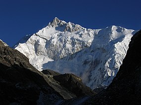
Khangchendzonga National Park, also Kanchenjunga Biosphere Reserve, is a national park and a biosphere reserve located in Sikkim, India. It was inscribed to the UNESCO World Heritage Sites list in July 2016, becoming the first "Mixed Heritage" site of India.[1] It was included in the UNESCO Man and the Biosphere Programme. The park is named after the mountain Kangchenjunga (alternative spelling Khangchendzonga), which is the third-highest peak in the world at 8,586 metres (28,169 ft) tall. The total area of the park is 849.5 km2 (328.0 sq mi).
Human history[edit | edit source]
There are a few Lepcha tribal settlements inside the park.
The park contains Tholung Monastery, a gompa located in the park's buffer zone. It is considered one of the most sacred monasteries in Sikkim.[2][3][4]
Geography[edit | edit source]
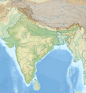
The Kanchenjunga Park is situated in the North and West Sikkim districts in the Indian state of Sikkim. It has an elevation of 1,829 m (6,001 ft) to over 8,550 m (28,050 ft) and has an area of 849.50 km2 (327.99 sq mi). It is one of the few high-altitude National parks of India and was recently included as a mixed-criteria UNESCO World Heritage site.[5]
In the north it adjoins the Qomolangma National Nature Preserve in Tibet, and in the west the Kanchenjunga Conservation Area in Nepal.[6]
Climate[edit | edit source]
Snowfall is heavy during the winter months and monsoon showers occur from May to mid-October.
Flora[edit | edit source]
The vegetation of the park include temperate broadleaf and mixed forests consisting of oaks, fir, birch, maple, willow.[5] The vegetation of the park also includes Alpine grasses and shrubs at higher altitudes along with many medicinal plants and herbs.[7]
Fauna[edit | edit source]
The park contains many mammal species including musk deer, Indian leopard, snow leopard, Himalayan tahr, dhole, sloth bear, viverrids, Himalayan black bear, red panda, Tibetan wild ass, Himalayan blue sheep, mainland serow, goral and takin, as well as reptiles including rat snake and Russell's viper.[citation needed]
A 2014 study revealed that the dhole has become very rare in the area. The wild dogs in the Khangchendzonga Biosphere Reserve are thought to belong to the rare and genetically distinct subspecies C. a. primaevus.[8]
Avifauna[edit | edit source]
About 550 species of birds are found inside the park including blood pheasant, satyr tragopan, osprey, Himalayan griffon, lammergeier, Western tragopan, green pigeon, Tibetan snowcock, snow pigeon, impeyan pheasant, Asian emerald cuckoo, sunbird and eagle.[5] A new species of bird named Himalayan thrush has been found in 2016. Its scientific name is Zoothera salimalii.[citation needed]
Park specific activities[edit | edit source]
Trekking[edit | edit source]
Most of the trekking routes start from Yuksom (145 km (90 mi) from Gangtok) in West Sikkim. Necessary Permit can be obtained from the Wildlife Education and Interpretation center at Yuksom or from the check post. State Tourism Department along with other travel agents organize treks to Dzongri (4,050 metres (13,290 ft)) and other places. The popular trek routes are:
- Yuksom - Tshoka - Dzongri
- Bakim - Dzongri - Thangshing - Samuteng - Goechala
- Dzongri Base Camp - Rathong – Khangerteng
- Thangshing - Lam Pokhari - Kasturi Orar - Labdang - Tashiding
Another popular trekking point includes a path to the Green Lake with Lachen, a village in North Sikkim as the starting point. Foreign nationals require a restricted area permit from the Ministry of Home Affairs, Government of India, Delhi to visit the park and the associated region. Indian nationals are required to obtain an Inner Line Permit from the State Home Department. Permission of the State Chief Wildlife Warden is also mandatory for everybody visiting the park. The important and popular routes are:
- Lucanes Jakchen-Yabuk-Rest Camp (Marco Polo Camp) - Green Lake
- Lachen-Thasngu (13,695 feet (4,174 m)) - Muguthang (16,000 feet (4,900 m)) - Thay La (17,000 feet (5,200 m)) - Khyoksa La (18,000 feet (5,500 m)) - Rest Camp - Green Lake.
Most of these trekking routes pass through the Kanchenjunga National Park and is shown in the film Singalila in the Himalaya
Transport[edit | edit source]
- Nearest airport:
- Pakyong Airport, a Greenfield project near Gangtok
- Bagdogra Airport, Darjeeling district, West Bengal (222 km (138 mi))
- Gangtok Helipad, East Sikkim district, Sikkim
- Nearest railhead: New Jalpaiguri, Siliguri Junction (221 km (137 mi))
- Nearest highway: NH 31A (Sevok – Gangtok)
- Nearest town: Yuksom in West and Chungthan in North (20 km (12 mi))
- Nearest city: Gangtok
References[edit | edit source]
- ↑ O'Neill, A. (2017). "Sikkim claims India's first mixed-criteria UNESCO World Heritage Site" (PDF). Current Science. 112 (5): 893–994. Retrieved 11 May 2017.
- ↑ "Tholung Monastery (1789 A.D)". Department of Ecclesiastical Affairs, Government of Sikkim. Department of Information Technology Government of Sikkim. Archived from the original on 15 April 2017. Retrieved 14 April 2017.
- ↑ "Tholung Monastery Trekking - 10 Days". Alpine Adventure Club. Alpine Adventure Club Treks & Expedition. Retrieved 14 April 2017.
- ↑ "Khangchendzonga National Park: Tholung monastery in the buffer zone of KBR". UNESCO World Heritage Centre. Retrieved 14 April 2017.
- ↑ 5.0 5.1 5.2 O'Neill, A. R. (2019). "Evaluating high-altitude Ramsar wetlands in the Sikkim Eastern Himalayas". Global Ecology and Conservation. 20 (e00715): 19. doi:10.1016/j.gecco.2019.e00715.
- ↑ Bhuju, U. R.; Shakya, P. R.; Basnet, T. B. & Shrestha, S. (2007). "Kanchenjunga Conservation Area". Nepal Biodiversity Resource Book. Protected Areas, Ramsar Sites, and World Heritage Sites. Kathmandu: International Centre for Integrated Mountain Development, Ministry of Environment, Science and Technology, in cooperation with United Nations Environment Programme, Regional Office for Asia and the Pacific. ISBN 978-92-9115-033-5.
- ↑ O'Neill, A. R.; Badola, H.K.; Dhyani, P. P.; Rana, S. K. (2017). "Integrating ethnobiological knowledge into biodiversity conservation in the Eastern Himalayas". Journal of Ethnobiology and Ethnomedicine. 13 (1): 21. doi:10.1186/s13002-017-0148-9. PMC 5372287. PMID 28356115.
- ↑ Bashir, T.; Bhattacharya, T.; Poudyal, K.; Roy, M.; Sathyakumar, S. (2014). "Precarious status of the Endangered Dhole Cuon alpinus in the high elevation Eastern Himalayan habitats of Khangchendzonga Biosphere Reserve, Sikkim, India". Oryx. 48 (1): 125–132. doi:10.1017/S003060531200049X.
External links[edit | edit source]
- Khangchendzonga National Park, WebIndia123
- Goecha La: In search of Kangchenjunga by George Thengummoottil - documentary on Goechala Trek inside Kangchenjunga National Park


