

→See also: Changed Place Of search |
small edit |
||
| Line 1: | Line 1: | ||
{{Use dmy dates|date=November | {{Short description|District in Bihar, India}} | ||
{{Use Indian English|date= | {{Use dmy dates|date=November 2025}} | ||
{{Use Indian English|date=November 2025}} | |||
{{Infobox settlement | {{Infobox settlement | ||
| name | | name = East Champaran district | ||
| settlement_type | | settlement_type = [[List of districts of Bihar|District of Bihar]] | ||
| total_type | | total_type = Total | ||
| native_name | | native_name = <!-- Please do not add any Indic script in this infobox, per WP:INDICSCRIPT policy. --> | ||
| image_map | | image_map = Bihar district location map East Champaran.svg | ||
| map_caption | | map_caption = Location of East Champaran district in Bihar | ||
| coordinates | | coordinates = | ||
| coor_pinpoint | | coor_pinpoint = Motihari | ||
| subdivision_type | | subdivision_type = Country | ||
| subdivision_name | | subdivision_name = {{flag|India}} | ||
| subdivision_type1 | | subdivision_type1 = [[States and union territories of India|State]] | ||
| subdivision_name1 | | subdivision_name1 = {{flagicon image|Bihar Government Banner.png}} [[Bihar]] | ||
| subdivision_type2 | | subdivision_type2 = [[Administrative divisions of Bihar|Division]] | ||
| subdivision_name2 | | subdivision_name2 = [[Tirhut division|Tirhut]] | ||
| established_title | | established_title = Established | ||
| established_date | | established_date = | ||
| seat_type | | seat_type = Headquarters | ||
| seat | | seat = [[Motihari]] | ||
| parts_type | | parts_type = [[Tehsils of India|Tehsils]] | ||
| parts_style | | parts_style = para | ||
| p1 | | p1 = | ||
| area_total_km2 | | area_total_km2 = 3968 | ||
| area_footnotes | | area_footnotes = | ||
| population_as_of | | population_as_of = 2011 | ||
| population_total | | population_total = 5,099,371 | ||
| population_footnotes | | population_footnotes = | ||
| population_urban | | population_urban = | ||
| population_density_km2 | | population_density_km2 = auto | ||
| demographics_type1 | | demographics_type1 = Demographics | ||
| demographics1_title1 | | demographics1_title1 = [[Literacy in India|Literacy]] | ||
| demographics1_info1 | | demographics_type2 = [[Language]] | ||
| demographics1_title2 | | demographics1_info1 = 55.79 per cent | ||
| demographics1_info2 | | demographics1_title2 = Sex ratio | ||
| leader_title | | demographics1_info2 = 901 | ||
| leader_name | | leader_title = [[District Magistrate]] ([[District magistrate|DM]]) | ||
| leader_title1 | | leader_name = Saurabh Jorwal ([[Indian Administrative Service|IAS]])<ref name="dm">{{cite web |title=Collector & District Magistrate - East Champaran |url=https://eastchamparan.nic.in/dm-profile-east-champaran/ |publisher=East Champaran District Administration |accessdate=18 September 2025}}</ref> | ||
| | | leader_title1 = [[Superintendent of Police]] ([[Superintendent of police (India)|SP]]) | ||
| | | leader_name1 =Swarn Prabhat ([[Indian Police Service|IPS]])<ref name="sp">{{cite web |title=Superintendent of Police - East Champaran |url=https://eastchamparan.nic.in/sp-east-champaran/ |publisher=East Champaran District Administration |accessdate=18 September 2025}}</ref> | ||
| | | leader_title2 = [[Lok Sabha|Lok Sabha constituencies]] | ||
| timezone1 | | leader_name2 = [[Purvi Champaran Lok Sabha constituency|Purvi Champaran]], [[Paschim Champaran Lok Sabha constituency|Paschim Champaran]], [[Sheohar Lok Sabha constituency|Sheohar]] | ||
| utc_offset1 | | leader_title3 = [[Vidhan Sabha|Vidhan Sabha constituencies]] | ||
| registration_plate | | leader_name3 = [[Raxaul Assembly constituency|Raxaul]], [[Sugauli Assembly constituency|Sugauli]], [[Narkatiya Assembly constituency|Narkatiya]], [[Harsidhi Assembly constituency|Harsidhi]], [[Govindganj Assembly constituency|Govindganj]], [[Kesaria Assembly constituency|Kesaria]], [[Kalyanpur, Purvi Champaran Assembly constituency|Kalyanpur]], [[Pipra, Purvi Champaran Assembly constituency|Pipra]], [[Madhuban, Bihar Assembly constituency|Madhuban]], [[Motihari Assembly constituency|Motihari]], [[Chiraia Assembly constituency|Chiraia]], [[Dhaka Assembly constituency|Dhaka]] | ||
| blank_name_sec1 | | demographics2_title1 = Official | ||
| blank_info_sec1 | | demographics2_info1 = [[Hindi]]<ref name="CSDOffLang1950">{{cite web|url=http://csd.bih.nic.in/Act&rule/Act1english.pdf|title=The Bihar Official Language Act, 1950|date=1950|website=Cabinet Secretariat Department, Government of Bihar|url-status=live|archive-url=https://web.archive.org/web/20150413072041/http://csd.bih.nic.in/Act%26rule/Act1english.pdf|archive-date=13 April 2015|access-date=9 April 2015}}</ref> | ||
| blank_name_sec2 | | demographics2_title2 = Additional official | ||
| blank_info_sec2 | | demographics2_info2 = [[Urdu]]<ref name="Benedikter2009">{{cite book|last=Benedikter|first=Thomas|url=https://books.google.com/books?id=vpZv2GHM7VQC&pg=PA89|title=Language Policy and Linguistic Minorities in India: An Appraisal of the Linguistic Rights of Minorities in India|date=2009|publisher=[[LIT Verlag]]|isbn=978-3-643-10231-7|location=Münster|page=89|access-date=10 April 2015|archive-url=https://web.archive.org/web/20151019053006/https://books.google.com/books?id=vpZv2GHM7VQC&pg=PA89&lpg=PA89|archive-date=19 October 2015|url-status=live}}</ref> | ||
| website | | demographics2_title3 = Regional | ||
| official_name | | demographics2_info3 = [[Bhojpuri language|Bhojpuri]] | ||
| image_skyline | | timezone1 = [[Indian Standard Time|IST]] | ||
| image_caption | | utc_offset1 = +05:30 | ||
| image_shield | | registration_plate = BR-05 | ||
| motto | | blank_name_sec1 = [[National Highway (India)|Major highways]] | ||
| image_seal | | blank_info_sec1 = *{{jct|NH|527D|country=IND}} | ||
* {{jct|NH|104|country=IND}} | |||
| blank_name_sec2 = Average annual precipitation | |||
| blank_info_sec2 = 1241 mm | |||
| postal_code_type = [[Postal Index Number|PIN]] | |||
| postal_code = 845401 (East Champaran)<ref>[https://indiapincodes.net/Bihar/Purbi-champaran/ East Champaran]</ref> | |||
| website = {{URL|https://eastchamparan.nic.in/}} | |||
| official_name = | |||
| image_skyline = {{Photomontage | |||
| photo1a = Buddhist Stupa at Kesariya (wide angle view) at Champaran (east) district of Bihar, India 08.jpg | |||
| photo2a = Motihari station, India, ca. 1906 (IMP-CSCNWW33-OS14-6).jpg| photo2b = Lauriya Araraj pillar of Ashoka, Champaran District.jpg| photo3a = Birth-Place-George-Orwell-Motihari.jpg | |||
| size = 280 | |||
| spacing = 1 | |||
| position = centre | |||
| border = 0 | |||
| color = white | |||
}} | |||
| image_caption = Clockwise from top: [[Kesaria stupa|Kesariya Stupa]], [[Lauriya Araraj]] pillar of [[Ashoka]], [[George Orwell]]'s birthplace, [[Bapudham Motihari railway station|Motihari station]] in 1906 | |||
| image_shield = Bihar Government Banner.png | |||
| motto = | |||
| image_seal = | |||
}} | }} | ||
'''East Champaran''' is an administrative district in the state of [[Bihar]] in | |||
'''East Champaran district''' or '''Purvi Champaran district''' is an administrative district in the [[Tirhut division]] of the state of [[Bihar]] in India. The district headquarter is located at [[Motihari]]. Prior to 1971, there was a single [[Champaran District]]. On 1 December 1971, it was divided into East and [[West Champaran]] (Purvi and Paschimi Champaran). In early days the land of East Chamapran was ruled by different kingdoms as Videha, Sunga, Kanvas. It is also believed that Champaran used to be a major part of King Janak's empire. Mahatma Gandhi started his famous Satyagraha movement from here. | |||
==About district== | ==About district== | ||
East Champaran District is functioning from 2 November 1972. The headquarter of district is at Motihari. It is situated at 26° 16′ to 27° 1′ North latitude and 84° 30′ to 85° 16′ East longitudes. [[Nepal]] makes its northern boundary, | East Champaran District is functioning from 2 November 1972. The headquarter of the district is at Motihari. It is situated at 26° 16′ to 27° 1′ North latitude and 84° 30′ to 85° 16′ East longitudes. [[Nepal]] makes its northern boundary, [[Sitamarhi district|Sitamarhi]] and [[Sheohar district|Sheohar]] eastern while [[Mehsi]], Muzaffarpur South and with part of [[Gopalganj district, India|Gopalganj]] and [[West Champaran district|West Champaran]] bounds it in western side. | ||
The district occupies an area of 3969 | The district occupies an area of {{cvt|3969|km2}} and has a population of 5,099,371 ({{As of|2011|lc=on}}). East Champaran is a part of [[Tirhut Division]].<ref>{{cite web|url=http://tirhut-muzaffarpur.bih.nic.in|title=Tirhut Division|website=tirhut-muzaffarpur.bih.nic.in|access-date=11 April 2018}}</ref> It was earlier part of the [[Red Corridor]]. | ||
As of 2011, it is the second most populous district of Bihar (out of [[Districts of Bihar| | As of 2011, it is the second most populous district of Bihar (out of [[Districts of Bihar|38]]), after [[Patna district|Patna]].<ref name="districtcensus">{{Cite web |date=2011 |title=District Census Handbook: East Champaran |url=https://censusindia.gov.in/nada/index.php/catalog/300/download/850/DH_2011_1002_PART_A_DCHB_PURBA_CHAMPARAN.pdf |website=[[Census of India]] |publisher=[[Registrar General and Census Commissioner of India]]}}</ref> | ||
East Champaran is the second most crowded district of Bihar. The district gets its name from the union of two words, champa and aranya. Champa alludes to scented blossom trees and Aranya alludes to the home or an encased spot. The name began back in when the district was encircled by a backwoods of magnolia (champa) trees. | |||
==Geography== | ==Geography== | ||
East Champaran district occupies an area of {{convert|3968|km2|sqmi}},<ref name="Reference Annual">{{cite book | The East Champaran district occupies an area of {{convert|3968|km2|sqmi}},<ref name="Reference Annual">{{cite book |last1=Srivastava, Dayawanti et al. (ed.) |title=India 2010: A Reference Annual |publisher=Additional Director General, Publications Division, [[Ministry of Information and Broadcasting (India)]], [[Government of India]] |year=2010 |isbn=978-81-230-1617-7 |edition=54th |location=New Delhi, India |pages=1118–1119 |chapter=States and Union Territories: Bihar: Government}}<!--| access-date = 11 October 2011 --></ref> comparatively equivalent to [[Vanuatu]]'s [[Espiritu Santo]].<ref name="Islands">{{cite web |date=18 February 1998 |title=Island Directory Tables: Islands by Land Area |url=http://islands.unep.ch/Tiarea.htm |url-status=dead |archive-url=https://web.archive.org/web/20210103205322/http://islands.unep.ch/Tiarea.htm |archive-date=3 January 2021 |access-date=11 October 2011 |publisher=[[United Nations Environment Program]] |quote=Espiritu Santo 3,956km2}}</ref> | ||
[[Gandak]], [[Burhi Gandak River|Burhi Gandak]] and [[Bagmati River|Baghmati]] are important rivers flowing through this region. | [[Gandak]], [[Burhi Gandak River|Burhi Gandak]] and [[Bagmati River|Baghmati]] are important rivers flowing through this region. | ||
==Demographics== | ==Demographics== | ||
{{historical populations|11=1901|12=10,27,835|13=1911|14=10,95,530|15=1921|16=11,14,162|17=1931|18=12,31,756|19=1941|20=13,76,352|21=1951|22=14,43,961|23=1961|24=16,81,089|25=1971|26=19,56,084|27=1981|28=24,25,501|29=1991|30=30,43,061|31=2001|32=39,39,773|33=2011|34=50,99,371|percentages=pagr|footnote=source:<ref> | {{historical populations|11=1901|12=10,27,835|13=1911|14=10,95,530|15=1921|16=11,14,162|17=1931|18=12,31,756|19=1941|20=13,76,352|21=1951|22=14,43,961|23=1961|24=16,81,089|25=1971|26=19,56,084|27=1981|28=24,25,501|29=1991|30=30,43,061|31=2001|32=39,39,773|33=2011|34=50,99,371|percentages=pagr|footnote=source:<ref>{{cite web |title=Table A-02 Decadal Variation in Population Since 1901: Bihar |url=https://censusindia.gov.in/nada/index.php/catalog/43343/download/47022/10%20A-2%20Bihar.pdf |website=census.gov.in|publisher=[[Registrar General and Census Commissioner of India]]}}</ref>|align=center}} | ||
|title=Religions in East Champaran | |||
{{bar box | |||
|title=Religions in East Champaran district (2011)<ref name="religion">{{Cite web |date=2011 |title=Table C-01 Population by Religion: Bihar |url=https://censusindia.gov.in/nada/index.php/catalog/11366/download/14479/DDW10C-01%20MDDS.XLS |website=censusindia.gov.in |publisher=[[Registrar General and Census Commissioner of India]]}}</ref> | |||
|titlebar=#Fcd116 | |titlebar=#Fcd116 | ||
|left1=Religion | |left1=Religion | ||
| Line 80: | Line 103: | ||
|float=right | |float=right | ||
|bars= | |bars= | ||
{{bar percent|[[ | {{bar percent|[[Hinduism]]|darkorange|80.14}} | ||
{{bar percent|[[Muslims]]|green|19.42}} | {{bar percent|[[Bihari Muslims|Islam]]|green|19.42}} | ||
{{bar percent| | {{bar percent|Other or not stated|black|0.44}} | ||
}} | }} | ||
According to the [[2011 census of India|2011 census]] East Champaran district has a [[Demographics of India|population]] of 5,099,371,<ref name="districtcensus"/> roughly equal to the [[United Arab Emirates]]<ref name="cia">{{cite web | author = US Directorate of Intelligence | title = Country Comparison:Population | url = https://www.cia.gov/library/publications/the-world-factbook/rankorder/2119rank.html | access-date = 1 October 2011 | quote = United Arab Emirates 5,148,664 | |||
According to the [[2011 census of India|2011 census]] East Champaran district has a [[Demographics of India|population]] of 5,099,371,<ref name="districtcensus"/> roughly equal to the [[United Arab Emirates]]<ref name="cia">{{cite web | author = US Directorate of Intelligence | title = Country Comparison:Population | url = https://www.cia.gov/library/publications/the-world-factbook/rankorder/2119rank.html | archive-url = https://web.archive.org/web/20070613004507/https://www.cia.gov/library/publications/the-world-factbook/rankorder/2119rank.html | url-status = dead | archive-date = 13 June 2007 | access-date = 1 October 2011 | quote = United Arab Emirates 5,148,664 | |||
}}</ref> or the US state of [[Colorado]].<ref>{{cite web | }}</ref> or the US state of [[Colorado]].<ref>{{cite web | ||
|url=http://2010.census.gov/2010census/data/apportionment-pop-text.php | |url=http://2010.census.gov/2010census/data/apportionment-pop-text.php | ||
|title=2010 Resident Population Data | |title=2010 Resident Population Data | ||
|publisher=U. S. Census Bureau | |publisher=U. S. Census Bureau | ||
|access-date=30 September 2011 | |access-date=30 September 2011 | ||
|quote=Colorado 5,029,196 | |||
|url-status=dead | |url-status=dead | ||
|archive-url=https://web.archive.org/web/20131019160532/http://2010.census.gov/2010census/data/apportionment-pop-text.php | |archive-url=https://web.archive.org/web/20131019160532/http://2010.census.gov/2010census/data/apportionment-pop-text.php | ||
|archive-date=19 October 2013 | |archive-date=19 October 2013 | ||
}}</ref> This gives it a ranking of 21st in India (out of a total of [[Districts of India|640]]).<ref name=districtcensus/> The district has a population density of {{convert| 1281 |PD/sqkm|PD/sqmi}}.<ref name=districtcensus/> Its [[Family planning in India|population growth rate]] over the decade 2001–2011 was 29.01%.<ref name=districtcensus/> | }}</ref> This gives it a ranking of 21st in India (out of a total of [[Districts of India|640]]).<ref name=districtcensus/> The district has a population density of {{convert|1281|PD/sqkm|PD/sqmi}}.<ref name=districtcensus/> Its [[Family planning in India|population growth rate]] over the decade 2001–2011 was 29.01%.<ref name=districtcensus/> East Champaran has a [[sex ratio]] of 901 [[Women in India|females]] for every 1000 males,<ref name=districtcensus/> and a [[Literacy in India|literacy rate]] of 55.79%. 7.87% of the population lives in urban areas. Scheduled Castes and Scheduled Tribes make up 12.74% and 0.24% of the population respectively.<ref name=districtcensus/> | ||
===Languages=== | ===Languages=== | ||
{{Pie chart| thumb = right| caption = Languages in East Champaran district (2011)<ref name=" | {{Pie chart | ||
|label1=[[Bhojpuri | |thumb = right | ||
|label2=[[ | |caption = Languages in East Champaran district (2011)<ref name="languages"/> | ||
|label3=[[ | |label1 = [[Bhojpuri Language|Bhojpuri]] |value1 = 82.67 |color1 = gold | ||
|label4=[[Bengali language|Bengali]] | | |label2 = [[Urdu language|Urdu]] |value2 = 7.33 |color2 = green | ||
| | |label3 = [[Hindi]] |value3 = 7.06 |color3 = orange | ||
|label4 = 'Other' Hindi |value4 = 2.58 |color4 = hotpink | |||
|label5 = [[Bengali language|Bengali]] |value5 = 0.26 |color5 = orchid | |||
|label6 = Others |value6 = 0.1 |color6 = grey | |||
}} | }} | ||
According to the 2011 census, 82.67% of the population spoke [[Bhojpuri | According to the 2011 census, 82.67% of the population spoke [[Bhojpuri Language|Bhojpuri]], 7.33% [[Urdu language|Urdu]] and 7.06% [[Hindi]] as their first language. 2.58% of the population spoke 'Others' under Hindi. The eastern border of the district lies in a transition between Bhojpuri and [[Bajjika]].<ref name="languages">{{Cite web |date=2011 |title=Table C-16 Population by Mother Tongue: Bihar |url=https://censusindia.gov.in/nada/index.php/catalog/10196/download/13308/DDW-C16-STMT-MDDS-1000.XLSX|website=censusindia.gov.in |publisher=[[Registrar General and Census Commissioner of India]]}}</ref> | ||
==Administrative divisions== | |||
The East Champaran district is divided into 6 [[Tehsil]] (sub-division): | |||
# [[Areraj]] | |||
# [[Chakia, Bihar|Chakia]] | |||
# [[Motihari]] | |||
# [[Pakaridayal]] | |||
# [[Raxaul]] | |||
# Sikarahana | |||
== Politics == | |||
{{transcluded section|source=18th Bihar Assembly}} | |||
{{#section:18th Bihar Assembly|MLA Header}} | |||
{{#section:18th Bihar Assembly|East Champaran district}} | |||
|} | |||
== Literature == | |||
Freedom fighter and author [[Ramesh Chandra Jha]] was the first person who penned down the literary history of Champaran. His notable works include ''Champaran Ki Sahitya Sadhana'' (चम्पारन की साहित्य साधना) (1958), ''Champaran:Literature & Literary Writers'' (चम्पारन: साहित्य और साहित्यकार) (1967) and ''Apne Aur Sapne:A Literary Journey Of Champaran'' (अपने और सपने: चम्पारन की साहित्य यात्रा) (1988).<ref>[https://archive.org/details/ApneAurSapneALitereryJourneyOfChamparanByRameshChandraJha/ Apne Aur Sapne : Online PDF book at Archive.org]</ref> | |||
== Tourist places == | |||
=== Someshwar Nath Mandir, Areraj === | |||
Someshwar Nath Mahadev Mandir is a well established temple situated in Areraj. The significant divinity of the heavenly temple is of Lord Shiva. Explorers and pilgrims of Lord Shiva go to the holy place from India as well as from Nepal. The merriments on the event of an occasional reasonable known as Shrawani Mela, during July and August, are really pleasant. There are numerous different temples nearby around and thus just, Areraj is known as the holy place of East Champaran. | |||
=== Ashokan Pillar === | |||
{{See also|Pillars of Ashoka}} | |||
[[File:Side view of Lauriya Nandangarh Ashoka Pillar.jpg|thumb|Ashoka Pillar]] | |||
Ashokan Pillar is situated in Lauria Nandangarh, or Lauriya Navandgarh which is a city or town around 14 km from Narkatiaganj and 28 km from Bettiah in West Champaran district of Bihar state in northern India. It is found near the banks of the Budhi Gandak River. Lauriya Nandangarh is a chronicled place which goes under West Champaran district of Bihar. | |||
=== Kesariya === | |||
[[File:Kesariya Stupa -kesariya- east champaran- Bihar.jpg|thumb|Kesariya Baudha Stupa]] | |||
Kesariya is arranged on the eastern banks of the [[River Gandak]] and views the enormous 104-feet-tall stupa, which is viewed as the tallest Buddhist stupa. In like manner, Kesariya orders conspicuous situations in East Champaran the travel industry just as history of Buddhism. The stupa was found in the year 1998. | |||
=== Raxaul === | |||
Raxaul is one of the most significant towns of the East Champaran district. By excellence of its topographical area, it is known as the Gateway to Nepal. | |||
=== Moti Jheel === | |||
Situated in the core of the Motihari city, Moti Jheel is the most excellent fascination of the city that isolates Motihari into two parts. | |||
=== NREGA Park === | |||
A lovely and beguiling spot to appreciate with loved ones. | |||
=== Champaran in Gallary === | |||
<gallery widths=180> | |||
File:Motihari station, India, ca. 1906 (IMP-CSCNWW33-OS14-6).jpg|Motihari Railway Station, 1906 | |||
File:Henry Bazaar, Motihari, India, ca. 1906 (IMP-CSCNWW33-OS14-10).jpg|Henry Bazaar(1906), Motihari | |||
File:Birth-Place-George-Orwell-Motihari.jpg|Birth palace of George Orwell, Motihari | |||
File:The Prime Minister, Shri Narendra Modi paying homage at the statue of Mahatma Gandhi, at Motihari, in Bihar (1).jpg|The Prime Minister, Shri Narendra Modi paying homage at the statue of Mahatma Gandhi, at Motihari. | |||
File:StonePillar GandhiMuseum.jpg|Stone Pillar Gandhi Museum | |||
File:Lauriya Araraj pillar of Ashoka, Champaran District.jpg|Lauriya Ashoka Pillar, Areraj | |||
</gallery> | |||
=== Gandhi Memorial === | |||
Gandhi Memorial is situated in Chandrahiya town, On his visit to Champaran Gandhiji was stopped in this town. Chandrahiya is around 8 km away from district headquarter Motihari. | |||
=== Champaran Satyagrah Park === | |||
The Champaran Satyagraha Shatabdi Park located at the district headquarter of East Champaran. The Park has been built by the Urban Development and Housing office. Neighborhood individuals appreciate the freshness of this park with family, relatives, friends on weekend and holidays. | |||
=== George Orwell Monument === | |||
The origin of perhaps the most commended scholars of the 20th century and the writer of a few acclaimed books, George Orwell. | |||
== | === Sitakund === | ||
Found 16 Kms from Pipra Railway Station, Sitakund is acclaimed as where Goddess Sita took a heavenly plunge.[[File:StonePillar_GandhiMuseum.jpg|thumb|Stone pillar at the Gandhi Museum]] | |||
==See also== | ==See also== | ||
* [[Districts of Bihar]] | * [[Districts of Bihar]] | ||
==References== | ==References== | ||
| Line 130: | Line 203: | ||
==External links== | ==External links== | ||
* [ | {{EB1911 poster|Champaran}} | ||
* [https://eastchamparan.bih.nic.in/ East Champaran district website] | |||
* [http://tirhut-muzaffarpur.bih.nic.in Official Website of Tirhut Division] | * [http://tirhut-muzaffarpur.bih.nic.in Official Website of Tirhut Division] | ||
* [https://www.apnamotihari.com/ Motihari (East Champaran)] | * [https://www.apnamotihari.com/ Motihari (East Champaran)] | ||
* [https://www.biharad.com/district/east-champaran East Champaran District Info] | * [https://www.biharad.com/district/east-champaran East Champaran District Info] {{Webarchive|url=https://web.archive.org/web/20210426161110/https://www.biharad.com/district/east-champaran |date=26 April 2021 }} | ||
{{Geographic location | {{Geographic location | ||
Revision as of 10:56, 20 November 2025
East Champaran district | |
|---|---|
_at_Champaran_(east)_district_of_Bihar,_India_08.jpg) .jpg)   Clockwise from top: Kesariya Stupa, Lauriya Araraj pillar of Ashoka, George Orwell's birthplace, Motihari station in 1906 | |
 Coat of arms | |
 Location of East Champaran district in Bihar | |
| Country |  India India |
| State |  Bihar Bihar |
| Division | Tirhut |
| Headquarters | Motihari |
| Government | |
| • District Magistrate (DM) | Saurabh Jorwal (IAS)[1] |
| • Superintendent of Police (SP) | Swarn Prabhat (IPS)[2] |
| • Lok Sabha constituencies | Purvi Champaran, Paschim Champaran, Sheohar |
| • Vidhan Sabha constituencies | Raxaul, Sugauli, Narkatiya, Harsidhi, Govindganj, Kesaria, Kalyanpur, Pipra, Madhuban, Motihari, Chiraia, Dhaka |
| Area | |
| • Total | 3,968 km2 (1,532 sq mi) |
| Population (2011) | |
| • Total | 5,099,371 |
| • Density | 1,300/km2 (3,300/sq mi) |
| Demographics | |
| • Literacy | 55.79 per cent |
| • Sex ratio | 901 |
| Language | |
| • Official | Hindi[3] |
| • Additional official | Urdu[4] |
| • Regional | Bhojpuri |
| Time zone | UTC+05:30 (IST) |
| PIN | 845401 (East Champaran)[5] |
| Vehicle registration | BR-05 |
| Major highways | |
| Average annual precipitation | 1241 mm |
| Website | eastchamparan |


East Champaran district or Purvi Champaran district is an administrative district in the Tirhut division of the state of Bihar in India. The district headquarter is located at Motihari. Prior to 1971, there was a single Champaran District. On 1 December 1971, it was divided into East and West Champaran (Purvi and Paschimi Champaran). In early days the land of East Chamapran was ruled by different kingdoms as Videha, Sunga, Kanvas. It is also believed that Champaran used to be a major part of King Janak's empire. Mahatma Gandhi started his famous Satyagraha movement from here.
About district
East Champaran District is functioning from 2 November 1972. The headquarter of the district is at Motihari. It is situated at 26° 16′ to 27° 1′ North latitude and 84° 30′ to 85° 16′ East longitudes. Nepal makes its northern boundary, Sitamarhi and Sheohar eastern while Mehsi, Muzaffarpur South and with part of Gopalganj and West Champaran bounds it in western side.
The district occupies an area of 3,969 km2 (1,532 sq mi) and has a population of 5,099,371 (as of 2011[update]). East Champaran is a part of Tirhut Division.[6] It was earlier part of the Red Corridor.
As of 2011, it is the second most populous district of Bihar (out of 38), after Patna.[7]
East Champaran is the second most crowded district of Bihar. The district gets its name from the union of two words, champa and aranya. Champa alludes to scented blossom trees and Aranya alludes to the home or an encased spot. The name began back in when the district was encircled by a backwoods of magnolia (champa) trees.
Geography
The East Champaran district occupies an area of 3,968 square kilometres (1,532 sq mi),[8] comparatively equivalent to Vanuatu's Espiritu Santo.[9] Gandak, Burhi Gandak and Baghmati are important rivers flowing through this region.
Demographics
| Year | Pop. | ±% p.a. |
|---|---|---|
| 1901 | 1,027,835 | — |
| 1911 | 1,095,530 | +0.64% |
| 1921 | 1,114,162 | +0.17% |
| 1931 | 1,231,756 | +1.01% |
| 1941 | 1,376,352 | +1.12% |
| 1951 | 1,443,961 | +0.48% |
| 1961 | 1,681,089 | +1.53% |
| 1971 | 1,956,084 | +1.53% |
| 1981 | 2,425,501 | +2.17% |
| 1991 | 3,043,061 | +2.29% |
| 2001 | 3,939,773 | +2.62% |
| 2011 | 5,099,371 | +2.61% |
| source:[10] | ||
According to the 2011 census East Champaran district has a population of 5,099,371,[7] roughly equal to the United Arab Emirates[12] or the US state of Colorado.[13] This gives it a ranking of 21st in India (out of a total of 640).[7] The district has a population density of 1,281 inhabitants per square kilometre (3,320/sq mi).[7] Its population growth rate over the decade 2001–2011 was 29.01%.[7] East Champaran has a sex ratio of 901 females for every 1000 males,[7] and a literacy rate of 55.79%. 7.87% of the population lives in urban areas. Scheduled Castes and Scheduled Tribes make up 12.74% and 0.24% of the population respectively.[7]
Languages
According to the 2011 census, 82.67% of the population spoke Bhojpuri, 7.33% Urdu and 7.06% Hindi as their first language. 2.58% of the population spoke 'Others' under Hindi. The eastern border of the district lies in a transition between Bhojpuri and Bajjika.[14]
Administrative divisions
The East Champaran district is divided into 6 Tehsil (sub-division):
- Areraj
- Chakia
- Motihari
- Pakaridayal
- Raxaul
- Sikarahana
Politics
| District | No. | Constituency | Name | Party | Alliance | Remarks | ||
|---|---|---|---|---|---|---|---|---|
| East Champaran | 10 | Raxaul | Pramod Kumar Sinha | BJP | NDA | |||
| 11 | Sugauli | Rajesh Kumar | Lok Janshakti Party | |||||
| 12 | Narkatiya | Vishal Kumar | JD(U) | |||||
| 13 | Harsidhi (SC) | Krishnanandan Paswan | BJP | |||||
| 14 | Govindganj | Raju Tiwari | Lok Janshakti Party | |||||
| 15 | Kesaria | Shalini Mishra | JD(U) | |||||
| 16 | Kalyanpur | Sachindra Prasad Singh | BJP | |||||
| 17 | Pipra | Shyambabu Prasad Yadav | ||||||
| 18 | Madhuban | Rana Randhir Singh | ||||||
| 19 | Motihari | Pramod Kumar | Minister | |||||
| 20 | Chiraia | Lal Babu Prasad Gupta | ||||||
| 21 | Dhaka | Faisal Rahman | RJD | Mahagathbandhan | ||||
Literature
Freedom fighter and author Ramesh Chandra Jha was the first person who penned down the literary history of Champaran. His notable works include Champaran Ki Sahitya Sadhana (चम्पारन की साहित्य साधना) (1958), Champaran:Literature & Literary Writers (चम्पारन: साहित्य और साहित्यकार) (1967) and Apne Aur Sapne:A Literary Journey Of Champaran (अपने और सपने: चम्पारन की साहित्य यात्रा) (1988).[15]
Tourist places
Someshwar Nath Mandir, Areraj
Someshwar Nath Mahadev Mandir is a well established temple situated in Areraj. The significant divinity of the heavenly temple is of Lord Shiva. Explorers and pilgrims of Lord Shiva go to the holy place from India as well as from Nepal. The merriments on the event of an occasional reasonable known as Shrawani Mela, during July and August, are really pleasant. There are numerous different temples nearby around and thus just, Areraj is known as the holy place of East Champaran.
Ashokan Pillar

Ashokan Pillar is situated in Lauria Nandangarh, or Lauriya Navandgarh which is a city or town around 14 km from Narkatiaganj and 28 km from Bettiah in West Champaran district of Bihar state in northern India. It is found near the banks of the Budhi Gandak River. Lauriya Nandangarh is a chronicled place which goes under West Champaran district of Bihar.
Kesariya

Kesariya is arranged on the eastern banks of the River Gandak and views the enormous 104-feet-tall stupa, which is viewed as the tallest Buddhist stupa. In like manner, Kesariya orders conspicuous situations in East Champaran the travel industry just as history of Buddhism. The stupa was found in the year 1998.
Raxaul
Raxaul is one of the most significant towns of the East Champaran district. By excellence of its topographical area, it is known as the Gateway to Nepal.
Moti Jheel
Situated in the core of the Motihari city, Moti Jheel is the most excellent fascination of the city that isolates Motihari into two parts.
NREGA Park
A lovely and beguiling spot to appreciate with loved ones.
Champaran in Gallary
-
 Motihari Railway Station, 1906
 -
 Henry Bazaar(1906), Motihari
 -
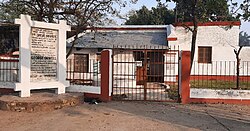 Birth palace of George Orwell, Motihari
 -
 The Prime Minister, Shri Narendra Modi paying homage at the statue of Mahatma Gandhi, at Motihari.
 -
 Stone Pillar Gandhi Museum
 -
 Lauriya Ashoka Pillar, Areraj
.jpg)
.jpg)
Gandhi Memorial
Gandhi Memorial is situated in Chandrahiya town, On his visit to Champaran Gandhiji was stopped in this town. Chandrahiya is around 8 km away from district headquarter Motihari.
Champaran Satyagrah Park
The Champaran Satyagraha Shatabdi Park located at the district headquarter of East Champaran. The Park has been built by the Urban Development and Housing office. Neighborhood individuals appreciate the freshness of this park with family, relatives, friends on weekend and holidays.
George Orwell Monument
The origin of perhaps the most commended scholars of the 20th century and the writer of a few acclaimed books, George Orwell.
Sitakund
Found 16 Kms from Pipra Railway Station, Sitakund is acclaimed as where Goddess Sita took a heavenly plunge.

See also
References
- ↑ "Collector & District Magistrate - East Champaran". East Champaran District Administration. Retrieved 18 September 2025.
- ↑ "Superintendent of Police - East Champaran". East Champaran District Administration. Retrieved 18 September 2025.
- ↑ "The Bihar Official Language Act, 1950" (PDF). Cabinet Secretariat Department, Government of Bihar. 1950. Archived (PDF) from the original on 13 April 2015. Retrieved 9 April 2015.
- ↑ Benedikter, Thomas (2009). Language Policy and Linguistic Minorities in India: An Appraisal of the Linguistic Rights of Minorities in India. Münster: LIT Verlag. p. 89. ISBN 978-3-643-10231-7. Archived from the original on 19 October 2015. Retrieved 10 April 2015.
- ↑ East Champaran
- ↑ "Tirhut Division". tirhut-muzaffarpur.bih.nic.in. Retrieved 11 April 2018.
- ↑ 7.0 7.1 7.2 7.3 7.4 7.5 7.6 "District Census Handbook: East Champaran" (PDF). Census of India. Registrar General and Census Commissioner of India. 2011.
- ↑ Srivastava, Dayawanti et al. (ed.) (2010). "States and Union Territories: Bihar: Government". India 2010: A Reference Annual (54th ed.). New Delhi, India: Additional Director General, Publications Division, Ministry of Information and Broadcasting (India), Government of India. pp. 1118–1119. ISBN 978-81-230-1617-7.
{{cite book}}:|last1=has generic name (help) - ↑ "Island Directory Tables: Islands by Land Area". United Nations Environment Program. 18 February 1998. Archived from the original on 3 January 2021. Retrieved 11 October 2011.
Espiritu Santo 3,956km2
- ↑ "Table A-02 Decadal Variation in Population Since 1901: Bihar" (PDF). census.gov.in. Registrar General and Census Commissioner of India.
- ↑ "Table C-01 Population by Religion: Bihar". censusindia.gov.in. Registrar General and Census Commissioner of India. 2011.
- ↑ US Directorate of Intelligence. "Country Comparison:Population". Archived from the original on 13 June 2007. Retrieved 1 October 2011.
United Arab Emirates 5,148,664
- ↑ "2010 Resident Population Data". U. S. Census Bureau. Archived from the original on 19 October 2013. Retrieved 30 September 2011.
Colorado 5,029,196
- ↑ 14.0 14.1 "Table C-16 Population by Mother Tongue: Bihar". censusindia.gov.in. Registrar General and Census Commissioner of India. 2011.
- ↑ Apne Aur Sapne : Online PDF book at Archive.org
External links
- East Champaran district website
- Official Website of Tirhut Division
- Motihari (East Champaran)
- East Champaran District Info Archived 26 April 2021 at the Wayback Machine
Places adjacent to East Champaran district | ||||||||||
|---|---|---|---|---|---|---|---|---|---|---|
| ||||||||||


