


>GreenC bot Rescued 1 archive link; reformat 1 link. Wayback Medic 2.5 |
Kamal Guha (talk | contribs) Updated |
||
| Line 25: | Line 25: | ||
| named_for = [[Bhima]] | | named_for = [[Bhima]] | ||
| government_type = [[Municipal corporation]] | | government_type = [[Municipal corporation]] | ||
| governing_body = | | governing_body = [[Greater Visakhapatnam Municipal Corporation]] | ||
[[Greater Visakhapatnam Municipal Corporation]] | |||
| unit_pref = Metric | | unit_pref = Metric | ||
| area_footnotes = | | area_footnotes = | ||
| Line 38: | Line 37: | ||
| population_demonym = | | population_demonym = | ||
| population_footnotes = <ref name="stats">{{cite web |title=Statistical Abstract of Andhra Pradesh, 2015 |url=https://desap.cgg.gov.in/jsp/website/gallery/Statistical%20Abstract%202015.pdf |website=Directorate of Economics & Statistics |publisher=Government of Andhra Pradesh |access-date=27 April 2019 |pages=40 |archive-url=https://web.archive.org/web/20190714020914/https://desap.cgg.gov.in/jsp/website/gallery/Statistical%20Abstract%202015.pdf |archive-date=14 July 2019 |url-status=dead }}</ref> | | population_footnotes = <ref name="stats">{{cite web |title=Statistical Abstract of Andhra Pradesh, 2015 |url=https://desap.cgg.gov.in/jsp/website/gallery/Statistical%20Abstract%202015.pdf |website=Directorate of Economics & Statistics |publisher=Government of Andhra Pradesh |access-date=27 April 2019 |pages=40 |archive-url=https://web.archive.org/web/20190714020914/https://desap.cgg.gov.in/jsp/website/gallery/Statistical%20Abstract%202015.pdf |archive-date=14 July 2019 |url-status=dead }}</ref> | ||
| demographics_type1 = | | demographics_type1 = [[Language]] | ||
| demographics1_title1 = Official | | demographics1_title1 = Official | ||
| demographics1_info1 = [[Telugu language|Telugu]] | | demographics1_info1 = [[Telugu language|Telugu]] | ||
| Line 54: | Line 53: | ||
| official_name = | | official_name = | ||
}} | }} | ||
'''Bheemunipatnam''' (also known as '''Bheemili'''<ref>{{Cite web|url=http://www.newindianexpress.com/states/andhra-pradesh/2019/may/30/103-objections-received-against-ward-delimitation-1983515.html|title=103 objections received against ward delimitation|website=The New Indian Express|location=Visakhapatnam|publication-date=30 May 2019|access-date=2019-06-10}}</ref>), is a suburb in the city of [[Visakhapatnam]], India. The | '''Bheemunipatnam''' (also known as '''Bheemili'''<ref>{{Cite web|url=http://www.newindianexpress.com/states/andhra-pradesh/2019/may/30/103-objections-received-against-ward-delimitation-1983515.html|title=103 objections received against ward delimitation|website=The New Indian Express|location=Visakhapatnam|publication-date=30 May 2019|access-date=2019-06-10}}</ref>), is a suburb in the city of [[Visakhapatnam]], India. The suburb was named after [[Bhima]] a character in the Hindu epic Mahabharata. It used to be administered under Bheemunipatnam municipality but in 2017 it was merged into [[GVMC]]. It is under the administration of [[Visakhapatnam revenue division]] and the headquarters is located at Bheemunipatnam. | ||
== History == | == History == | ||
=== Buddhism === | === Buddhism === | ||
[[File:Buddha Statue at Bheemili beach Road.jpg|thumbnail|Buddha Statue at Bheemunipatnam Beach Road|alt=]] | [[File:Buddha Statue at Bheemili beach Road.jpg|thumbnail|left|Buddha Statue at Bheemunipatnam Beach Road|alt=]] | ||
Historical evidences of [[Buddhist]] Culture have been noticed at Bheemunipatnam dating back to 3rd century [[BCE]] on the hillock [[Pavurallakonda]]<ref>{{cite web|url=http://museums.ap.nic.in/b-sites.htm |title=Dept. of Archaeology & Museums |publisher=Museums.ap.nic.in |access-date=2012-10-24 |url-status=dead |archive-url=https://web.archive.org/web/20120209160246/http://museums.ap.nic.in/b-sites.htm |archive-date=9 February 2012 }}</ref> (also known as Narsimhaswami Konda locally) in the town. Buddhist remains were found during the excavations here along with Relic caskets. Both the schools of Buddhism [[Hinayana]] and [[Mahayana]] were propagated in this land and also to the far east lands from the port of [[River Gosthani]]. See [[pavurallakonda]] page for more details. | Historical evidences of [[Buddhist]] Culture have been noticed at Bheemunipatnam dating back to 3rd century [[BCE]] on the hillock [[Pavurallakonda]]<ref>{{cite web|url=http://museums.ap.nic.in/b-sites.htm |title=Dept. of Archaeology & Museums |publisher=Museums.ap.nic.in |access-date=2012-10-24 |url-status=dead |archive-url=https://web.archive.org/web/20120209160246/http://museums.ap.nic.in/b-sites.htm |archive-date=9 February 2012 }}</ref> (also known as Narsimhaswami Konda locally) in the town. Buddhist remains were found during the excavations here along with Relic caskets. Both the schools of Buddhism [[Hinayana]] and [[Mahayana]] were propagated in this land and also to the far east lands from the port of [[River Gosthani]]. See [[pavurallakonda]] page for more details. | ||
=== Dutch settlements === | === Dutch settlements === | ||
[[File:C.P. Keller - Plaan van het dorp Bimelepatnam en 'SEComps. loge.jpg|thumb|A Dutch map of Bheemunipatnam by Coenraad Pieter Keller with the projected new fort from 1756.]] | [[File:C.P. Keller - Plaan van het dorp Bimelepatnam en 'SEComps. loge.jpg|thumb|left|A Dutch map of Bheemunipatnam by Coenraad Pieter Keller with the projected new fort from 1756.]] | ||
Known to the Dutch as Bimilipatnam, Bheemunipatnam was one among the major [[Dutch people|Dutch]] settlements<ref>{{cite web |url=http://www.baynews.in/vizag-special/it-is-a-ruin-of-colonial-legacy |title=It is a ruin of colonial legacy | BayNews | The New Voice of Vizag |publisher=Baynews.in |date=2010-09-24 |access-date=2012-10-24 |archive-url=https://web.archive.org/web/20131229033838/http://www.baynews.in/vizag-special/it-is-a-ruin-of-colonial-legacy |archive-date=29 December 2013 |url-status=dead }}</ref> of the [[Dutch Coromandel]] coast in the 17th century. There are remnants of the [[Dutch East India Company]] trading post when the town was a port. The town contains one of the oldest Christian cemeteries on the coast.<ref>{{cite web|url=http://www.hindu.com/2007/04/12/stories/2007041209870200.htm |archive-url=https://web.archive.org/web/20080220113242/http://www.hindu.com/2007/04/12/stories/2007041209870200.htm |url-status=dead |archive-date=2008-02-20 |title=Andhra Pradesh / Visakhapatnam News : Bhimili: lost in time and tide |date=2007-04-12 |newspaper=[[The Hindu]] |access-date=2012-10-24}}</ref> Bhimili also had a currency mint<ref>{{cite web|author=Ramani M |url=http://heavydutytravel.blogspot.in/search/label/copper%20coins |title=The History of Vizag: copper coins |publisher=Heavydutytravel.blogspot.in |access-date=2012-10-24}}</ref> during the times of Dutch. Portuguese also visited bhimili in the same time as the dutch. St.Peter's church is a historical monument which signifies the ancient architecture.<ref>{{Cite news|last=Ganguly|first=Nivedita|url=https://www.thehindu.com/life-and-style/travel/the-17th-century-dutch-township-of-bheemunipatnam-is-awash-with-history-but-one-that-is-slowly-vanishing-in-the-face-of-neglect/article25111473.ece|title=Bheemunipatnam: This Dutch township is full of history|date=2018-10-03|work=The Hindu|access-date=2020-04-11|language=en-IN|issn=0971-751X}}</ref> | Known to the Dutch as Bimilipatnam, Bheemunipatnam was one among the major [[Dutch people|Dutch]] settlements<ref>{{cite web |url=http://www.baynews.in/vizag-special/it-is-a-ruin-of-colonial-legacy |title=It is a ruin of colonial legacy | BayNews | The New Voice of Vizag |publisher=Baynews.in |date=2010-09-24 |access-date=2012-10-24 |archive-url=https://web.archive.org/web/20131229033838/http://www.baynews.in/vizag-special/it-is-a-ruin-of-colonial-legacy |archive-date=29 December 2013 |url-status=dead }}</ref> of the [[Dutch Coromandel]] coast in the 17th century. There are remnants of the [[Dutch East India Company]] trading post when the town was a port. The town contains one of the oldest Christian cemeteries on the coast.<ref>{{cite web|url=http://www.hindu.com/2007/04/12/stories/2007041209870200.htm |archive-url=https://web.archive.org/web/20080220113242/http://www.hindu.com/2007/04/12/stories/2007041209870200.htm |url-status=dead |archive-date=2008-02-20 |title=Andhra Pradesh / Visakhapatnam News : Bhimili: lost in time and tide |date=2007-04-12 |newspaper=[[The Hindu]] |access-date=2012-10-24}}</ref> Bhimili also had a currency mint<ref>{{cite web|author=Ramani M |url=http://heavydutytravel.blogspot.in/search/label/copper%20coins |title=The History of Vizag: copper coins |publisher=Heavydutytravel.blogspot.in |access-date=2012-10-24}}</ref> during the times of Dutch. Portuguese also visited bhimili in the same time as the dutch. St.Peter's church is a historical monument which signifies the ancient architecture.<ref>{{Cite news|last=Ganguly|first=Nivedita|url=https://www.thehindu.com/life-and-style/travel/the-17th-century-dutch-township-of-bheemunipatnam-is-awash-with-history-but-one-that-is-slowly-vanishing-in-the-face-of-neglect/article25111473.ece|title=Bheemunipatnam: This Dutch township is full of history|date=2018-10-03|work=The Hindu|access-date=2020-04-11|language=en-IN|issn=0971-751X}}</ref> | ||
| Line 78: | Line 69: | ||
=== East India Company === | === East India Company === | ||
The British [[East India Company]] made Bheemunipatnam their main trading base of the east coast. The Bhimili port used to operate passenger vessels to Madras and Calcutta during the British Raj. The big clock tower in the town was built by the British. | The British [[East India Company]] made Bheemunipatnam their main trading base of the east coast. The Bhimili port used to operate passenger vessels to Madras and Calcutta during the British Raj. The big clock tower in the town was built by the British. | ||
===District formation=== | |||
In 1802, Visakhapatnam was formed when the [[Northern Circars]] were split into five districts. <ref name=’toi’>{{cite web| url = https://timesofindia.indiatimes.com/city/visakhapatnam/first-formed-under-the-empire-aps-map-shaped-and-reshaped-over-two-centuries/articleshow/90528597.cms | title= AP new districts: First formed under the empire, Andhra Pradesh’s map shaped and reshaped over two centuries |work = Umamaheswara Rao |publisher= The Times of India, 30 March 2022| access-date = 27 January 2024}}</ref>[[Srikakulam district]] was carved out of Vishakhapatnam district in 1950<ref>{{cite web| url = https://www.indiastatdistricts.com/andhrapradesh/srikakulam-district | title= District level information of Srikakulam district (Andhra Pradesh) |publisher= IndiaStatDistricts | access-date = 27 January 2024}}</ref><ref name=’toi’/> [[Vizianagaram district]] was formed in 1979 by transferring some portions of Srikakulam and Viskhapatnam districts. <ref name=’toi’/> | |||
In 2022, as a part of the raising the number of districts in Andhra Pradesh from 13 to 26, Visakhapatnam district was split into three districts – [[Alluri Sitharama Raju district]], [[Anakapalli district]] and [[Visakhapatnam district]].<ref>{{cite web| url = https://www.yovizag.com/visakhapatnam-divided-into-3-new-districts-by-the-ap-state-government/ | title= Visakhapatnam divided into 3 new districts by the AP State Government |publisher= Yo!Vizag| access-date = 27 January 2024}}</ref> | |||
== Geography == | |||
Bheemunipatnam is located about 40 km from Visakhapatnam Airport, about 31 km from Visakhapatnam railway station and 29 km from Visakhapatnam city central bus station. It lies to the north of [[Visakhapatnam City]] and is loosely bordered by Rushikonda to the south and Bay of Bengal to the east, Madhurawada to the west, Bhogapuram to the north. | |||
== Demographics == | == Demographics == | ||
According to [[Imperial Gazetteer of India]],<ref>[https://dsal.uchicago.edu/reference/gazetteer/pager.html?objectid=DS405.1.I34_V08_244.gif Bimlipatnam tahsil in Imperial Gazetteer of India, Vol. 8; pp: 238.]</ref> It was entirely Zamindari land belonging to the Vizianagram estate. {{As of|2001}} India [[census]],<ref>{{cite web|url=http://www.censusindia.net/results/town.php?stad=A&state5=999|archive-url=https://web.archive.org/web/20040616075334/http://www.censusindia.net/results/town.php?stad=A&state5=999|archive-date=2004-06-16|title= Census of India 2001: Data from the 2001 Census, including cities, villages and towns (Provisional)|access-date=2008-11-01|publisher= Census Commission of India}}</ref> it had a population of 44,156. Males constitute 49% of the population and females 51%. Bheemunipatnam has an average literacy rate of 60%, higher than the national average of 59.5%; with male literacy of 67% and female literacy of 54%. 11% of the population is under 6 years of age. | According to [[Imperial Gazetteer of India]],<ref>[https://dsal.uchicago.edu/reference/gazetteer/pager.html?objectid=DS405.1.I34_V08_244.gif Bimlipatnam tahsil in Imperial Gazetteer of India, Vol. 8; pp: 238.]</ref> It was entirely Zamindari land belonging to the Vizianagram estate. {{As of|2001}} India [[census]],<ref>{{cite web|url=http://www.censusindia.net/results/town.php?stad=A&state5=999|archive-url=https://web.archive.org/web/20040616075334/http://www.censusindia.net/results/town.php?stad=A&state5=999|archive-date=2004-06-16|title= Census of India 2001: Data from the 2001 Census, including cities, villages and towns (Provisional)|access-date=2008-11-01|publisher= Census Commission of India}}</ref> it had a population of 44,156. Males constitute 49% of the population and females 51%. Bheemunipatnam has an average literacy rate of 60%, higher than the national average of 59.5%; with male literacy of 67% and female literacy of 54%. 11% of the population is under 6 years of age. | ||
== | ==Culture== | ||
[[ | === Narasimha temple === | ||
There is a Hindu temple dedicated to [[Lord Narasimha]] on the eastern side of [[Pavurallakonda]] facing the sea. As per the historical evidences the temple is constructed around 14th century by Mindi<ref>{{cite web|author=Sudhakar |url=http://vishakapatnamonline.blogspot.in/2008/06/one-of-finest-sea-resorts-in-country.html |title=Incredible India: Bhimili |publisher=Vishakapatnamonline.blogspot.in |date=2008-06-25 |access-date=2012-10-24}}</ref> Kings. There are two more temples in the town of Bhimili, which date back to the times of Chola's as Bheemeswaralayam and Choleswaralayam. | |||
== Transport== | |||
Bheemili is well connected by road. NH16 or AH45 passes through the Mandal. It also has major District roads and State Highways connecting it to nearby Mandals and Visakhapatnam. [[APSRTC]] runs bus services from Visakhapatnam bus station to Bheemili. | |||
;[[Andhra Pradesh State Road Transport Corporation|APSRTC]] | |||
Routes: | |||
{| Class="sortable wikitable" | |||
|- | |||
!Route | |||
!Starts | |||
! Ends | |||
!Time | |||
!Via | |||
|- | |||
|999 | |||
|Bhimili | |||
|R.T.C Complex | |||
|Every 15 mins | |||
|NTR circle bus stop,Dorathota, | |||
Bhimili x road,Boyapalem,Madhurawada,Yandad,Zoo park,Hanumanthawaka,Venkojipalem,Maddilapalem,Central Bus Station(CBST) | |||
|- | |||
|900k | |||
|Bhimili Beach | |||
|Visakhapatnam Railway Station | |||
|Every 15 mins | |||
| Bml Beach,INS Kalinga,Uppada,Mangamaripeta,Thotlakonda Beach,Ramanaidu Studios,Rushikonda Beach,Geetham University,Sagaranagar Beach,Kailasagiri Roapway,MVP,Waltair,Siripuram,Andhra University,VMRDA CITY CENTRAL PARK,RTC COMPLEX,Allipuram | |||
|- | |||
|900T | |||
|Bhimili | |||
|Tagarapuvalasa | |||
|7.15,8.00,8.45,9.30 and 3.00,3.45,4.30,5.15,6.00 | |||
|NTR circle Bus Stop,sun school,ketenpeta,rayapalem,chillapeta,chittivalsa, Andhra Bank tgp | |||
|- | |||
|55k | |||
|Bhimili | |||
|Gajuwaka | |||
|7.00am,7.00pm | |||
|NTR circle bus stop, Tagarapuvalasa,sangivalasa,Anandhapuram,Nillakundilu,Pendurti,vepagunta,NAD, Airport,Old Gajuwaka,New Gajuwaka | |||
|- | |||
|} | |||
== Politics == | == Politics == | ||
{|class="wikitable" width="350px" | {|class="wikitable" width="350px" | ||
!width="50px"|Year | !width="50px"|Year | ||
| Line 147: | Line 183: | ||
|} | |} | ||
== Picture gallery == | |||
[[File:Panoramic view of Gosthani confluence BayofBengal Bhimili.JPG|thumb|center|800px|Panoramic view of [[River Gosthani]] confluence into [[Bay of Bengal]] at Bhimili]] | |||
== | The [[lighthouse]] dated to 1868 was built during Dutch settlement on the shores of [[Bheemili Beach]].<ref name="lighthouse">{{cite news|title=Bhimili lighthouse to be demolished|url=http://www.thehindu.com/news/cities/Visakhapatnam/bhimili-lighthouse-to-be-demolished/article4368697.ece|access-date=7 June 2016|work=The Hindu|date=1 February 2013|language=en-IN}}</ref> Some of the [[Buddhist]] sites are [[Bojjannakonda]], [[Bavikonda]], Lingalakonda, [[Pavurallakonda]], Salihundam and Thotlakonda. | ||
==See also== | |||
* [[Visakhapatnam district#Administrative divisions|Revenue divisions and mandals in Visakhapatnam district]] | |||
== | == References == | ||
{{Reflist}} | {{Reflist}} | ||
* {{cite book |last=Bos |first=J. |editor-last1=Storms |editor-first1=M. |editor-last2=Cams |editor-first2=M. |editor-last3=Demhardt |editor-first3=I. |editor-last4=Ormeling |editor-first4=F. |title=Mapping Asia: Cartographic Encounters Between East and West. Lecture Notes in Geoinformation and Cartography |publisher=Springer |date=2019 |pages=219–228 |chapter=A Disastrous Project: C. P. Keller and the Fortification (Plans) of Bimilipatnam |doi=10.1007/978-3-319-90406-1_15 }} | * {{cite book |last=Bos |first=J. |editor-last1=Storms |editor-first1=M. |editor-last2=Cams |editor-first2=M. |editor-last3=Demhardt |editor-first3=I. |editor-last4=Ormeling |editor-first4=F. |title=Mapping Asia: Cartographic Encounters Between East and West. Lecture Notes in Geoinformation and Cartography |publisher=Springer |date=2019 |pages=219–228 |chapter=A Disastrous Project: C. P. Keller and the Fortification (Plans) of Bimilipatnam |doi=10.1007/978-3-319-90406-1_15 }} | ||
| Line 199: | Line 201: | ||
{{Visakhapatnam}} | {{Visakhapatnam}} | ||
{{Neighbourhoods of Visakhapatnam}} | {{Neighbourhoods of Visakhapatnam}} | ||
{{ | {{Visakhapatnam district}} | ||
[[Category:Neighbourhoods in Visakhapatnam]] | [[Category:Neighbourhoods in Visakhapatnam]] | ||
[[Category:Mandal headquarters in Visakhapatnam district]] | |||
Revision as of 07:18, 28 January 2024
Bheemunipatnam
Bheemili | |
|---|---|
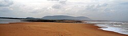
 Hill-top view of Bheemunipatnam town | |
  Bheemunipatnam Location in Andhra Pradesh, India | |
| Coordinates: 17°53′11″N 83°26′50″E / 17.886385°N 83.447109°E | |
| Country | India |
| State | Andhra Pradesh |
| District | Visakhapatnam |
| Named for | Bhima |
| Government | |
| • Type | Municipal corporation |
| • Body | Greater Visakhapatnam Municipal Corporation |
| Area | |
| • Total | 18.88 km2 (7.29 sq mi) |
| Population (2011)[1] | |
| • Total | 52,110 |
| • Density | 2,800/km2 (7,100/sq mi) |
| Language | |
| • Official | Telugu |
| Time zone | UTC+5:30 (IST) |
| PIN | 531163/62 |
| Vehicle Registration | AP31 (Former) AP39 (from 30 January 2019)[2] |
| Vidhan Sabha | Bheemili |
| Lok Sabha constituency | Visakhapatnam |
Bheemunipatnam (also known as Bheemili[3]), is a suburb in the city of Visakhapatnam, India. The suburb was named after Bhima a character in the Hindu epic Mahabharata. It used to be administered under Bheemunipatnam municipality but in 2017 it was merged into GVMC. It is under the administration of Visakhapatnam revenue division and the headquarters is located at Bheemunipatnam.
History
Buddhism

Historical evidences of Buddhist Culture have been noticed at Bheemunipatnam dating back to 3rd century BCE on the hillock Pavurallakonda[4] (also known as Narsimhaswami Konda locally) in the town. Buddhist remains were found during the excavations here along with Relic caskets. Both the schools of Buddhism Hinayana and Mahayana were propagated in this land and also to the far east lands from the port of River Gosthani. See pavurallakonda page for more details.
Dutch settlements

Known to the Dutch as Bimilipatnam, Bheemunipatnam was one among the major Dutch settlements[5] of the Dutch Coromandel coast in the 17th century. There are remnants of the Dutch East India Company trading post when the town was a port. The town contains one of the oldest Christian cemeteries on the coast.[6] Bhimili also had a currency mint[7] during the times of Dutch. Portuguese also visited bhimili in the same time as the dutch. St.Peter's church is a historical monument which signifies the ancient architecture.[8]
After Bheemunipatnam was plundered by Maratha troops in 1754, the local regent permitted the Dutch East India Company to construct a fort in the village, for which military engineer Coenraad Pieter Keller drew up plans. The fort that was constructed subsequently collapsed twice, for which Keller had to defend himself in front of his superiors in Batavia.[9]
East India Company
The British East India Company made Bheemunipatnam their main trading base of the east coast. The Bhimili port used to operate passenger vessels to Madras and Calcutta during the British Raj. The big clock tower in the town was built by the British.
District formation
In 1802, Visakhapatnam was formed when the Northern Circars were split into five districts. [10]Srikakulam district was carved out of Vishakhapatnam district in 1950[11][10] Vizianagaram district was formed in 1979 by transferring some portions of Srikakulam and Viskhapatnam districts. [10]
In 2022, as a part of the raising the number of districts in Andhra Pradesh from 13 to 26, Visakhapatnam district was split into three districts – Alluri Sitharama Raju district, Anakapalli district and Visakhapatnam district.[12]
Geography
Bheemunipatnam is located about 40 km from Visakhapatnam Airport, about 31 km from Visakhapatnam railway station and 29 km from Visakhapatnam city central bus station. It lies to the north of Visakhapatnam City and is loosely bordered by Rushikonda to the south and Bay of Bengal to the east, Madhurawada to the west, Bhogapuram to the north.
Demographics
According to Imperial Gazetteer of India,[13] It was entirely Zamindari land belonging to the Vizianagram estate. As of 2001[update] India census,[14] it had a population of 44,156. Males constitute 49% of the population and females 51%. Bheemunipatnam has an average literacy rate of 60%, higher than the national average of 59.5%; with male literacy of 67% and female literacy of 54%. 11% of the population is under 6 years of age.
Culture
Narasimha temple
There is a Hindu temple dedicated to Lord Narasimha on the eastern side of Pavurallakonda facing the sea. As per the historical evidences the temple is constructed around 14th century by Mindi[15] Kings. There are two more temples in the town of Bhimili, which date back to the times of Chola's as Bheemeswaralayam and Choleswaralayam.
Transport
Bheemili is well connected by road. NH16 or AH45 passes through the Mandal. It also has major District roads and State Highways connecting it to nearby Mandals and Visakhapatnam. APSRTC runs bus services from Visakhapatnam bus station to Bheemili.
Routes:
| Route | Starts | Ends | Time | Via |
|---|---|---|---|---|
| 999 | Bhimili | R.T.C Complex | Every 15 mins | NTR circle bus stop,Dorathota,
Bhimili x road,Boyapalem,Madhurawada,Yandad,Zoo park,Hanumanthawaka,Venkojipalem,Maddilapalem,Central Bus Station(CBST) |
| 900k | Bhimili Beach | Visakhapatnam Railway Station | Every 15 mins | Bml Beach,INS Kalinga,Uppada,Mangamaripeta,Thotlakonda Beach,Ramanaidu Studios,Rushikonda Beach,Geetham University,Sagaranagar Beach,Kailasagiri Roapway,MVP,Waltair,Siripuram,Andhra University,VMRDA CITY CENTRAL PARK,RTC COMPLEX,Allipuram |
| 900T | Bhimili | Tagarapuvalasa | 7.15,8.00,8.45,9.30 and 3.00,3.45,4.30,5.15,6.00 | NTR circle Bus Stop,sun school,ketenpeta,rayapalem,chillapeta,chittivalsa, Andhra Bank tgp |
| 55k | Bhimili | Gajuwaka | 7.00am,7.00pm | NTR circle bus stop, Tagarapuvalasa,sangivalasa,Anandhapuram,Nillakundilu,Pendurti,vepagunta,NAD, Airport,Old Gajuwaka,New Gajuwaka |
Politics
| Year | Candidate | Party |
|---|---|---|
| 1951 | Kaligotla Suryanarayana | |
| 1955 | Gottumukkala Jagannadha Raju | |
| 1972 | Raja Sagi Soma Sundara Suryanarayana Raju | INC |
| 1978 | Datla Jagannadha Raju | INC(I) |
| 1983 | Pusapati Ananda Gajapati Raju | TDP |
| 1985 | Raja Sagi Devi Prasanna Appala Narasimha Raju | TDP |
| 1989 | Raja Sagi Devi Prasanna Appala Narasimha Raju | TDP |
| 1994 | Raja Sagi Devi Prasanna Appala Narasimha Raju | TDP |
| 1999 | Raja Sagi Devi Prasanna Appala Narasimha Raju | TDP |
| 2004 | Karri Seetharamu | INC |
| 2009 | Muttamsetti Srinivasa Rao | PRP |
| 2014 | Ganta Srinivasa Rao | TDP |
| 2019 | Muttamsetti Srinivasa Rao | YSRCP |
Picture gallery

The lighthouse dated to 1868 was built during Dutch settlement on the shores of Bheemili Beach.[16] Some of the Buddhist sites are Bojjannakonda, Bavikonda, Lingalakonda, Pavurallakonda, Salihundam and Thotlakonda.
See also
References
- ↑ "Statistical Abstract of Andhra Pradesh, 2015" (PDF). Directorate of Economics & Statistics. Government of Andhra Pradesh. p. 40. Archived from the original (PDF) on 14 July 2019. Retrieved 27 April 2019.
- ↑ "New 'AP 39' code to register vehicles in Andhra Pradesh launched". The New Indian Express. Vijayawada. 31 January 2019. Retrieved 9 June 2019.
- ↑ "103 objections received against ward delimitation". The New Indian Express. Visakhapatnam. 30 May 2019. Retrieved 10 June 2019.
- ↑ "Dept. of Archaeology & Museums". Museums.ap.nic.in. Archived from the original on 9 February 2012. Retrieved 24 October 2012.
- ↑ "It is a ruin of colonial legacy | BayNews | The New Voice of Vizag". Baynews.in. 24 September 2010. Archived from the original on 29 December 2013. Retrieved 24 October 2012.
- ↑ "Andhra Pradesh / Visakhapatnam News : Bhimili: lost in time and tide". The Hindu. 12 April 2007. Archived from the original on 20 February 2008. Retrieved 24 October 2012.
- ↑ Ramani M. "The History of Vizag: copper coins". Heavydutytravel.blogspot.in. Retrieved 24 October 2012.
- ↑ Ganguly, Nivedita (3 October 2018). "Bheemunipatnam: This Dutch township is full of history". The Hindu. ISSN 0971-751X. Retrieved 11 April 2020.
- ↑ Bos 2019.
- ↑ 10.0 10.1 10.2 "AP new districts: First formed under the empire, Andhra Pradesh's map shaped and reshaped over two centuries". Umamaheswara Rao. The Times of India, 30 March 2022. Retrieved 27 January 2024.
- ↑ "District level information of Srikakulam district (Andhra Pradesh)". IndiaStatDistricts. Retrieved 27 January 2024.
- ↑ "Visakhapatnam divided into 3 new districts by the AP State Government". Yo!Vizag. Retrieved 27 January 2024.
- ↑ Bimlipatnam tahsil in Imperial Gazetteer of India, Vol. 8; pp: 238.
- ↑ "Census of India 2001: Data from the 2001 Census, including cities, villages and towns (Provisional)". Census Commission of India. Archived from the original on 16 June 2004. Retrieved 1 November 2008.
- ↑ Sudhakar (25 June 2008). "Incredible India: Bhimili". Vishakapatnamonline.blogspot.in. Retrieved 24 October 2012.
- ↑ "Bhimili lighthouse to be demolished". The Hindu. 1 February 2013. Retrieved 7 June 2016.
- Bos, J. (2019). "A Disastrous Project: C. P. Keller and the Fortification (Plans) of Bimilipatnam". In Storms, M.; Cams, M.; Demhardt, I.; Ormeling, F. (eds.). Mapping Asia: Cartographic Encounters Between East and West. Lecture Notes in Geoinformation and Cartography. Springer. pp. 219–228. doi:10.1007/978-3-319-90406-1_15.
External links


| District headquarters |  | |
|---|---|---|
| Revenue division | ||
| Mandal | ||
| Mandal headquarters | ||
| Cities and towns | ||
| Locations other than cities and towns | ||
| See also | ||
| Templates of other districts | ||