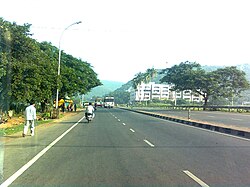
Visalakshi Nagar
Visalakshi Nagar | |
|---|---|
Neighbourhood | |
 NH Road near Visalakshinagar | |
| Lua error in Module:Location_map at line 526: Unable to find the specified location map definition: "Module:Location map/data/India Visakhapatnam" does not exist. | |
| Coordinates: 17°45′21″N 83°20′21″E / 17.755822°N 83.339220°ECoordinates: 17°45′21″N 83°20′21″E / 17.755822°N 83.339220°E | |
| Country | |
| State | Andhra Pradesh |
| District | Visakhapatnam |
| Government | |
| • Body | Greater Visakhapatnam Municipal Corporation |
| Languages | |
| • Official | Telugu |
| Time zone | UTC+5:30 (IST) |
| PIN | 530043 |
| Vehicle registration | AP-31 |
Visalakshinagar is a neighborhood situated on the northern part of Visakhapatnam City, India. The area, which falls under the local administrative limits of Greater Visakhapatnam Municipal Corporation, is about 5 km from the Dwaraka Nagar which is city centre.[1] Visalakshinagar is located at the entrance of Visakhapatnam City on National Highway 16.[2]
Transport[edit | edit source]
- APSRTC routes
| Route Number | Start | End | Via |
|---|---|---|---|
| 52V | Sagarnagar | Old Head Post Office | Visalakshinagar, Hanumanthuwaka, Maddilapalem, RTC Complex, Jagadamba Centre, Town Kotharoad |
| 52S | Sagarnagar | Old Head Post Office | Visalakshinagar, Hanumanthuwaka, Maddilapalem, RTC Complex, Jagadamba Centre, Town Kotharoad |
| 52Z | Sagarnagar | RK Beach | Visalakshinagar, Hanumanthuwaka, Maddilapalem, RTC Complex, Jagadamba Centre |
| 52V/G | Gollala Yendada | Town Kotharoad | Visalakshinagar, Hanumanthuwaka, Maddilapalem, RTC Complex, Jagadamba Centre |
| 10K | Kailasagiri | RTC Complex | Police Quarters, Appughar, Vudapark, RK Beach, Jagadamba Centre |
References[edit | edit source]
- ↑ "location". times of india. 12 March 2017. Retrieved 23 September 2017.
- ↑ "about". new indian express. 11 March 2017. Retrieved 22 September 2017.
