Mangamaripeta
Mangamaripeta | |
|---|---|
Neighbourhood | |
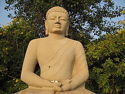
 Buddha statue at Thotlakonda | |
| Lua error in Module:Location_map at line 526: Unable to find the specified location map definition: "Module:Location map/data/India Visakhapatnam" does not exist. | |
| Coordinates: 17°50′00″N 83°24′47″E / 17.833198°N 83.412932°ECoordinates: 17°50′00″N 83°24′47″E / 17.833198°N 83.412932°E | |
| Country | |
| State | Andhra Pradesh |
| District | Visakhapatnam |
| Government | |
| • Body | Greater Visakhapatnam Municipal Corporation |
| Languages | |
| • Official | Telugu |
| Time zone | UTC+5:30 (IST) |
| PIN | 530048 |
| Vehicle registration | AP-31 |
Mangamaripeta is a village with a watersport beach in Visakhapatnam, India. It is believed that the region was under the kingdom of Kalingas and later the beach was used to serve as the promotional centre of Buddhism. The beach is popular for Thotlakonda, a hill embracing a Buddhist complex, located at an elevation of 128 m.[1]
Mangamaripeta is a part of GVMC ward number 4, Bheemunipatnam. One of its prominent landmarks is a natural stone arch.[2]
Mangamaripeta is accessible via 900k or 900T from the Dwaraka bus station via Siripuram, Appugarh, Gitam.[citation needed]
References[edit | edit source]
- ↑ "about". thehindu. 10 October 2017. Retrieved 21 September 2017.
- ↑ "Natural arch at Mangamaripeta cries for attention". The Hindu. 13 November 2020. Retrieved 13 February 2021.
