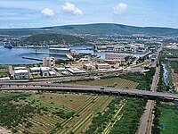
Chinagantyada
Chinagantyada | |
|---|---|
Neighbourhood | |
 100 feet road | |
| Coordinates: 17°40′50″N 83°11′24″E / 17.680569°N 83.189938°ECoordinates: 17°40′50″N 83°11′24″E / 17.680569°N 83.189938°E | |
| Country | |
| State | Andhra Pradesh |
| District | Visakhapatnam |
| Government | |
| • Body | Greater Visakhapatnam Municipal Corporation |
| Language | |
| • Official | Telugu |
| Time zone | UTC+5:30 (IST) |
| PIN | 530026 |
| Vehicle registration | AP-31,32 |
Chinagantyada is a neighborhood situated in the Visakhapatnam City, in Visakhapatnam district in Andhra Pradesh, India. The area, which falls under the local administrative limits of Greater Visakhapatnam Municipal Corporation, [1]
History[edit]
In 1802, Visakhapatnam was formed when the Northern Circars were split into five districts. [2]Srikakulam district was carved out of Vishakhapatnam district in 1950[3][2] Vizianagaram district was formed in 1979 by transferring some portions of Srikakulam and Viskhapatnam districts. [2]
In 2022, as a part of the raising the number of districts in Andhra Pradesh from 13 to 26, Visakhapatnam district was split into three districts – Alluri Sitharama Raju district, Anakapalli district and Visakhapatnam district.[4]
Transport[edit]
- APSRTC routes
| Route Number | Start | End | Via |
|---|---|---|---|
| 400K | Kurmannapalem | RTC Complex | Old Gajuwaka, New Gajuwaka, Sriharipuram, Malkapuram, Scindia, Naval Dockyard, Visakhapatnam Railway Station |
| 99K | Kurmannapalem | R.K.Beach | Old Gajuwaka, New Gajuwaka, Sriharipuram, Malkapuram, Scindia, Naval Dockyard, Old Post Office, Jagadamba, Maharanipeta |
| 38K | Kurmannaplem | RTC Complex | BHPV, Airport, NAD Kotharoad, Birla Junction, Gurudwar |
| 38T | Steel Plant | RTC Complex | Kurmannapalem, Old Gajuwaka, BHPV, Airport, NAD Kotharoad, Birla Junction, Gurudwar |
| 111 | Kurmannapalem | Tagarapuvalasa | Old Gajuwaka, BHPV, Airport, NAD Kotharoad, Birla Junction, Gurudwar, Maddilapalem, Hanumanthuwaka, Yendada, Madhurawada, Anandapuram |
| 600 | Scindia | Anakapalle | Lankelapalem, Kurmannapalem, Old Gajuwaka, New Gajuwaka, Sriharipuram, Malkapuram |
| 38Y | Duvvada Railway Station | RTC Complex | Kurmannaplem, Old Gajuwaka, BHPV, Airport, NAD Kotharoad, Birla Junction, Gurudwar |
| 404 | Steelplant Main Gate | PM Palem | Old Gajuwaka, BHPV, Airport, NAD Kotharoad, Birla Junction, Gurudwar, Maddilapalem, Hanumanthuwaka, Yendada |
See also[edit]
References[edit]
- ↑ "location". get pincode. 12 April 2013. Retrieved 12 September 2017.
- ↑ 2.0 2.1 2.2 "AP new districts: First formed under the empire, Andhra Pradesh's map shaped and reshaped over two centuries". Umamaheswara Rao. The Times of India, 30 March 2022. Retrieved 27 January 2024.
- ↑ "District level information of Srikakulam district (Andhra Pradesh)". IndiaStatDistricts. Retrieved 27 January 2024.
- ↑ "Visakhapatnam divided into 3 new districts by the AP State Government". Yo!Vizag. Retrieved 27 January 2024.


