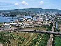
Mulagada
This article needs additional citations for verification. (December 2017) |
Mulagada | |
|---|---|
Neighbourhood | |
| Coordinates: 17°41′57″N 83°13′26″E / 17.699095°N 83.224024°ECoordinates: 17°41′57″N 83°13′26″E / 17.699095°N 83.224024°E | |
| Country | |
| State | Andhra Pradesh |
| District | Visakhapatnam |
| Founded by | Government of Andhra Pradesh |
| Government | |
| • Type | Mayor-council |
| • Body | GVMC |
| Population | |
| • Total | 175,575 |
| Language | |
| • Official | Telugu |
| Time zone | UTC+5:30 (IST) |
| PIN | 530011 |
| Vidhan Sabha constituency | Visakhapatnam West |
| Lok Sabha constituency | Visakhapatnam |
Mulagada is a neighbourhood in the city of Visakhapatnam and headquarters of Mulagada mandal in the Visakhapatnam district of Andhra Pradesh, India. It is under the administration of Visakhapatnam revenue division.
History[edit | edit source]
In 1802, Visakhapatnam was formed when the Northern Circars were split into five districts. [1]Srikakulam district was carved out of Vishakhapatnam district in 1950[2][1] Vizianagaram district was formed in 1979 by transferring some portions of Srikakulam and Viskhapatnam districts. [1]
In 2022, as a part of the raising the number of districts in Andhra Pradesh from 13 to 26, Visakhapatnam district was split into three districts – Alluri Sitharama Raju district, Anakapalli district and Visakhapatnam district.[3]
Geography[edit | edit source]
It is located on the south fringe of Visakhapatnam city.[4][5]
The mandal is located within the jurisdiction of the Greater Visakhapatnam Municipal Corporation, which is responsible for the civic amenities in Mulagada . It is bounded by Gajuwaka mandal and Pedagantyada mandal.
Wards[edit | edit source]
Mulagada mandal consists of following wards
- Malkapuram
- Gullalapalem
- Mulagada
Nearby localities[edit | edit source]
Malkapuram (2km), Gajuwaka (3km), Pedagantyada (6km) are the nearby localities.
Economy[edit | edit source]
Since most of the heavy industries established in Visakhapatnam, like Hindustan Petroleum Corporation Limited, Hindustan Shipyard Limited, Naval Dockyard Visakhapatnam and Coromandel International lie in close proximity of Mulagada, its growth has mirrored that of Visakhapatnam.
Organisations like Hindustan Petroleum Corporation Limited, Coromandel International, Hindustan Shipyard Limited, Eastern Naval Command are located in this area.

Coromandel International Limited is an Indian corporation founded in the early 1960s by IMC and Chevron Companies of USA. Originally named Coromandel Fertilisers, the company is in the business of fertilizers, pesticides and specialty nutrients. The company is also in rural retail business at Visakhapatnam, Andhra Pradesh through its Mana Gromor Centres.
Hindustan Shipyard Limited (HSL) is a shipyard located in Visakhapatnam on the east coast of India. Founded as the Scindia Shipyard, it was built by industrialist Walchand Hirachand as a part of The Scindia Steam Navigation Company Ltd. Walchand selected Visakhapatnam as a strategic and ideal location and took possession of land in November 1940.
[edit | edit source]
The Eastern Naval Command of the Indian Navy is one of its three major formations.[5] It utilizes Visakhapatnam as its headquarters, and has bases there and at Kolkata. It is the first and largest naval command in India.
Transport[edit | edit source]
- APSRTC routes
| Route Number | Start | End | Via |
|---|---|---|---|
| 400 | Gajuwaka | RTC Complex | New Gajuwaka, Sriharipuram, Malkapuram, Scindia, Naval Dockyard, Visakhapatnam Railway Station |
| 99 | Gajuwaka | R.K.Beach | New Gajuwaka, Sriharipuram, Malkapuram, Scindia, Naval Dockyard, Old Post Office, Jagadamba, Maharanipeta |
| 600 | Scindia | Anakapalli | Malkapuram, Sriharipuram, New Gajuwaka, Old Gajuwaka, Aganampudi, Lankelapalem |
| 55 | Scindia | Simhachalam | Malkapuram, Sriharipuram, New Gajuwaka, Old Gajuwaka, Narava, Airport, NAD Junction, Gopalapatnam |
| 55K | Scindia | Kothavalasa | Malkapuram, Sriharipuram, New Gajuwaka, Old Gajuwaka, Narava, Airport, NAD Junction, Gopalapatnam, Pendurthi |
| 38J | Janatha Colony | RTC Complex | Jawahar Nagar, Coromandel, New Gajuwaka, Old Gajuwaka, Narava, Airport, NAD Junction, Kancherapalem, Gurudwar |
See also[edit | edit source]
References[edit | edit source]
- ↑ 1.0 1.1 1.2 "AP new districts: First formed under the empire, Andhra Pradesh's map shaped and reshaped over two centuries". Umamaheswara Rao. The Times of India, 30 March 2022. Retrieved 27 January 2024.
- ↑ "District level information of Srikakulam district (Andhra Pradesh)". IndiaStatDistricts. Retrieved 27 January 2024.
- ↑ "Visakhapatnam divided into 3 new districts by the AP State Government". Yo!Vizag. Retrieved 27 January 2024.
- ↑ "Mulagada - Village in Visakhapatnam(u) Mandal". indiagrowing.com. Retrieved 17 December 2017.
- ↑ 5.0 5.1 "Mandals in Visakhapatnam District, Andhra Pradesh". census2011.co.in. Retrieved 17 December 2017.


