



m Bot: Delinking broken file(s) using script (info) |
No edit summary |
||
| Line 1: | Line 1: | ||
{{ | {{Short description|Geographic region of Andhra Pradesh, India}} | ||
{{Use Indian English|date=August 2016}} | {{Use Indian English|date=August 2016}} | ||
{{Use dmy dates|date= | {{Use dmy dates|date=April 2024}} | ||
{{Infobox settlement | {{Infobox settlement | ||
| name | | name = Coastal Andhra | ||
| native_name | | native_name = Kōstā Āndhra | ||
| other_name = | |||
| other_name | | settlement_type = [[Andhra Pradesh#Administrative divisions|Geographic region of Andhra Pradesh]] | ||
| settlement_type | | image_skyline = {{multiple image | ||
| image_skyline | | border = infobox | ||
| | | total_width = 300 | ||
| | | image_style = | ||
| | | perrow = 1/3/2/1 | ||
| image_map | | caption_align = center | ||
| map_caption | | image1 = Vizag View from Kailasagiri.jpg | ||
| coordinates | | caption1 = [[Visakhapatnam|Skyline of Visakhapatnam]] | ||
| subdivision_type | | image2 = Kanakadurga Temple gopuram.jpg | ||
| subdivision_name | | caption2 = [[Kanaka Durga Temple]], [[Vijayawada]] | ||
| subdivision_type1 | | image3 = Machilipatnam beach at dusk11 09.jpg | ||
| subdivision_name1 | | caption3 = [[Machilipatnam|Machilipatnam beach]] | ||
| established_title | | image4 = Dhyaan buddha Amaravthi.jpg | ||
| established_date | | caption4 = [[Dhyana Buddha statue]] at [[Amaravathi, Palnadu district|Amaravathi]] | ||
| founder | | image5 = Konaseema .jpg | ||
| named_for | | caption5 = [[Konaseema]] | ||
| government_type | | image6 = Agriculture college bapatla.jpg | ||
| governing_body | | caption6 = [[Agricultural College, Bapatla]] | ||
| unit_pref | | image7 = District Collectorate of West Godavari (May 2019) 3.jpg | ||
| area_footnotes | | caption7 = Eluru District Collectorate | ||
| area_total_km2 | }} | ||
| area_rank | | image_alt = | ||
| elevation_footnotes | | image_caption = | ||
| elevation_m | | image_map = Coastal Andhra in Andhra Pradesh.png | ||
| population_total | | map_caption = Coastal Andhra region (old districts) highlighted in Andhra Pradesh | ||
| population_as_of | | nickname = | ||
| population_footnotes | | coordinates = | ||
| population_density_km2 | | subdivision_type = Country | ||
| population_rank | | subdivision_name = {{IND}} | ||
| population_demonym | | subdivision_type1 = [[States and union territories of India|State]] | ||
| demographics_type1 | | subdivision_name1 = {{flagicon image|}}[[Andhra Pradesh]] | ||
| demographics1_title1 | | established_title = <!-- Established --> | ||
| timezone1 | | subdivision_type2 = [[Districts of Andhra Pradesh|Districts]] | ||
| utc_offset1 | | subdivision_name2 = *[[Srikakulam district]] | ||
| postal_code_type | *[[Vizianagaram district]] | ||
| postal_code | *[[Parvathipuram Manyam district]] | ||
| registration_plate | *[[Alluri Sitharama Raju district|Alluri district]] | ||
| blank1_name_sec1 | *[[Polavaram district]] | ||
| blank1_info_sec1 | *[[Visakhapatnam district]] | ||
| website | *[[Anakapalli district]] | ||
| footnotes | *[[Kakinada district]] | ||
| demographics1_info1 | *[[Konaseema district]] | ||
| demographics1_title2 | *[[East Godavari district]] | ||
| demographics1_info2 | *[[West Godavari district]] | ||
*[[Eluru district]] | |||
*[[NTR district]] | |||
*[[Krishna district]] | |||
*[[Guntur district]] | |||
*[[Palnadu district]] | |||
*[[Bapatla district]] | |||
*[[Prakasam district]] | |||
*[[Markapuram district]] | |||
*[[SPSR Nellore district]] | |||
| subdivision_type3 = Largest city | |||
| subdivision_name3 = *[[Visakhapatnam]] | |||
| subdivision_type4 = Major Cities | |||
| subdivision_name4 = *[[Vijayawada]] | |||
*[[Guntur]] | |||
*[[Nellore]] | |||
*[[Rajamundry]] | |||
*[[Kakinada]] | |||
*[[Bhimavaram]] | |||
*[[Eluru]] | |||
*[[Tuni]] | |||
| established_date = | |||
| founder = | |||
| named_for = | |||
| government_type = | |||
| governing_body = | |||
| unit_pref = Metric | |||
| area_footnotes = <ref>{{Cite web|url=http://www.mapsofindia.com/maps/andhrapradesh/andhrapradesh-factsheet.htm|title=Andhra Pradesh Fact Sheet|work=mapsofindia.com}}</ref> | |||
| area_total_km2 = 91915 | |||
| area_rank = | |||
| elevation_footnotes = | |||
| elevation_m = | |||
| population_total = 34,195,655 | |||
| population_as_of = 2011 | |||
| population_footnotes = <ref>{{Cite web |date=2013-11-12 |title=Wayback Machine |url=http://www.ap.gov.in/Other%20Docs/Population.pdf |access-date=2023-02-24 |archive-url=https://web.archive.org/web/20131112141602/http://www.ap.gov.in/Other%20Docs/Population.pdf |archive-date=12 November 2013 }}</ref> | |||
| population_density_km2 = | |||
| population_rank = | |||
| population_demonym = | |||
| demographics_type1 = Languages | |||
| demographics1_title1 = Official | |||
| timezone1 = [[Indian Standard Time|IST]] | |||
| utc_offset1 = +05:30 | |||
| postal_code_type = <!-- [[Postal Index Number|PIN]] --> | |||
| postal_code = | |||
| registration_plate = AP05, AP06, AP07, AP08, AP16, AP18, AP26, AP27, AP37, AP39 | |||
| blank1_name_sec1 = Largest airport | |||
| blank1_info_sec1 = [[Visakhapatnam Airport]] | |||
| website = | |||
| footnotes = | |||
| demographics1_info1 = [[Telugu language|Telugu]] | |||
| demographics1_title2 = Others | |||
| demographics1_info2 = | |||
}} | }} | ||
[[ | '''Coastal Andhra''', also known as '''Kosta Andhra''' ([[International Alphabet of Sanskrit Transliteration|IAST]]: Kōstā Āndhra), is a geographic region in the Indian state of [[Andhra Pradesh]], comprising the coastal districts of the state between the [[Eastern Ghats]] and the [[Bay of Bengal]], from the northern border with [[Odisha|Orissa]] to [[Rayalaseema]] in the south.<ref name=":0">{{Cite journal |last=Ojha |first=Shreya |date=November 2019 |title=Demographic Profile of Coastal Andhra Pradesh, India |url=https://www.ijser.org/researchpaper/Demographic-Profile-of-Coastal-Andhra-Pradesh-India.pdf |journal=International Journal of Scientific & Engineering Research |volume=10 |issue=11 |issn=2229-5518}}</ref> It includes major cities [[Visakhapatnam]], [[Vijayawada]] and [[Guntur City]] as well as the state capital [[Amaravati]] and is recognized for its fertile lands, rich cultural heritage, and economic importance. Coastal Andhra plays a significant role in the state's agricultural output, particularly in rice and tobacco production, supported by abundant water resources from the [[Godavari River|Godavari]], [[Krishna River|Krishna]], and [[Penna River|Penna]] rivers.<ref>{{Cite book |last=Rao |first=Desari Panduranga |url=https://books.google.com/books?id=6oMiAQAAMAAJ |title=Trends in Indian Transport System: A Districtwise Study |publisher=Inter-India Publications |year=1985 |isbn=978-0-86590-701-0 |pages=158}}</ref><ref>{{Cite web |title=Indian States fish production |url=http://dof.gov.in/sites/default/files/2020-08/HandbookonFS2018.pdf}}</ref> | ||
While Coastal Andhra generally includes the districts along the Bay of Bengal, the [[North Andhra|Uttarandhra]] (Northern Andhra) area is sometimes regarded as distinct due to its unique cultural and historical background. Coastal Andhra shares borders with the [[Rayalaseema]] region of Andhra Pradesh and the state of [[Telangana]]. Covering an area of {{convert|91915|sqkm}}, Coastal Andhra accounts for 58% of Andhra Pradesh's total area and, as per the [[2011 Census of India]], hosts a population of over 3.4 [[crore]], constituting 69.20% of the state's population. Coastal Andhra was formerly part of the [[Madras State]] until 1953 and then became part of [[Andhra State]] from 1953 to 1956.<ref name=":0" /> | |||
Historically, Coastal Andhra has been a centre of trade and culture, featuring strong traditions in literature, music, and dance. The region contributed actively to the [[Indian independence movement]] and continues to impact the state's economy through industries such as information technology, petroleum, and pharmaceuticals. It is also home to major ports in [[Visakhapatnam Port|Visakhapatnam]] and [[Kakinada Port|Kakinada]], enhancing its status as a critical industrial and trading hub. Proximity to the Bay of Bengal, however, makes the region susceptible to tropical cyclones and coastal erosion, prompting investments in disaster preparedness and coastal management initiatives.<ref name=":0" /> | |||
== History == | |||
The region of Andhra emerged as a prominent political power during the [[Maurya Empire]]. Historical accounts by Greek ambassador [[Megasthenes]] ({{Circa|310 BCE}}) reference Andhra as a flourishing region under the [[Satavahana dynasty|Satavahanas]] before the [[Common Era]].<ref name=":6">{{Cite book |last=V. D. |first=Mahajan |author-link=Vidya Dhar Mahajan |url=https://books.google.com/books?id=7TJlDwAAQBAJ&dq=Megasthenes+Andhras&pg=PA297 |title=Ancient India |date=2016 |publisher=[[S. Chand Group|S. Chand Publishing]] |isbn=978-93-5253-132-5 |pages=297}}{{Cbignore}}</ref><ref>{{Cite news |title=History of Andhra Pradesh |url=http://www.aponline.gov.in/quick%20links/hist-cult/history.html |url-status=dead |archive-url=https://web.archive.org/web/20120716182646/http://www.aponline.gov.in/quick%20links/hist-cult/history.html |archive-date=16 July 2012 |access-date=22 July 2012 |publisher=[[Government of Andhra Pradesh]]}}</ref> The Satavahana dynasty dominated the [[Deccan Plateau]] from the 1st century BCE to the 3rd century CE.<ref name="CH_2009">{{Cite book |author=Charles Higham |url=https://books.google.com/books?id=H1c1UIEVH9gC&pg=PA299 |title=Encyclopedia of ancient Asian civilizations |publisher=Infobase Publishing |year=2009 |isbn=978-1-4381-0996-1 |page=299 |access-date=6 March 2016}}{{Cbignore}}</ref> It had trade relations with the Roman Empire.<ref>{{Cite book |last1=Dutt |first1=Sukumar |url=https://books.google.com/books?id=lxRHYFd0fB4C&pg=PA132 |title=Buddhist monks and monasteries of India: Their history and their contribution to Indian culture |date=1988 |publisher=Motilal Banarsidass |isbn=978-81-20-80498-2 |page=132 |access-date=29 April 2024}}{{Cbignore}}</ref> The Satavahanas made [[Dharanikota|Dhanyakataka]]-[[Amaravathi, Palnadu district|Amaravathi]] their capital. According to historian [[Stanley Wolpert]], it might have been the most prosperous city in India in 2nd century CE.<ref>{{Cite web |title=History of Amaravati |url=https://crda.ap.gov.in/APCRDADOCS/DataModuleFIles/History/01~10531.Historical%20timeline.pdf |url-status=live |archive-url=https://web.archive.org/web/20240519110822/https://crda.ap.gov.in/APCRDADOCS/DataModuleFIles/History/01~10531.Historical%20timeline.pdf |archive-date=19 May 2024 |access-date=29 July 2024 |website=crda.ap.gov.in |publisher=Government of AP}}</ref><ref name=":10">{{Cite book |last=Wolpert |first=Stanley A. |author-link=Stanley Wolpert |url=https://books.google.com/books?id=QSZuAAAAMAAJ&q=Andhra |title=A new history of India |date=1989 |publisher=[[Oxford University Press]] |isbn=978-0-19-505636-5 |pages=75, 76 |quote=Amaravati on the banks of the Krishna, which was later the southeast capital of the Satavahanas, flourished in its trade with Rome, Ceylon, and Southeast Asia, and may well have been the most prosperous city of India during the second century of the Christian era.}}{{Cbignore}}</ref> | |||
Coastal Andhra was subsequently governed by the [[Eastern Chalukyas|Eastern Chalukya dynasty]] between the 7th and 12th centuries CE, followed by successive rule under the [[Chola dynasty|Chola]], [[Kakatiya dynasty|Kakatiya]], [[Reddy Kingdom|Reddys]] and [[Vijayanagara Empire|Vijayanagara empires]].<ref>{{Cite web |title=About Eastern Chalukyas – Official AP state government portal – AP state portal |url=http://www.ap.gov.in/eastern-chalukyas/ |url-status=dead |archive-url=https://web.archive.org/web/20160617075255/http://www.ap.gov.in/eastern-chalukyas/ |archive-date=17 June 2016 |access-date=27 May 2016}}</ref><ref>For a map of their territory see: {{cite book |last1=Schwartzberg |first1=Joseph E. |url=https://dsal.uchicago.edu/reference/schwartzberg/pager.html?object=185 |title=A Historical atlas of South Asia |date=1978 |publisher=University of Chicago Press |isbn=0226742210 |location=Chicago |page=147, map XIV.3 (b)}}</ref><ref>{{Cite book |last=Durga Prasad |first=J. |url=http://202.41.85.234:8000/gw_44_5/hi-res/hcu_images/G2.pdf |title=History of the Andhras up to 1565 A. D. |publisher=P.G. Publisher |year=1988 |location=Guntur |pages=231–235 |access-date=27 January 2007 |archive-url=https://web.archive.org/web/20060422120411/http://202.41.85.234:8000/gw_44_5/hi-res/hcu_images/G2.pdf |archive-date=22 April 2006 |url-status=dead}}</ref> According to 11th-century inscriptions, the geographical boundaries of Coastal Andhra extended from the [[Mahendragiri (Odisha)|Mahendragiri]] mountains in the northeastern border near [[Odisha|Orissa]]'s [[Gajapati district]], to the [[Srikalahasteeswara temple|Kalahasti Temple]] in [[Tirupati district]], and the [[Mallikarjuna Temple, Srisailam|Srisailam Temple]] in [[Nandyal district]].<ref name="google">{{Cite book |author=Austin Cynthia Talbot Assistant Professor of History and Asian Studies University of Texas |url=https://books.google.com/books?id=pfAKljlCJq0C&pg=PA36 |title=Precolonial India in Practice : Society, Region, and Identity in Medieval Andhra: Society, Region, and Identity in Medieval Andhra |date=23 August 2001 |publisher=Oxford University Press |isbn=978-0-19-803123-9 |pages=36–}}</ref> | |||
[[ | |||
[[ | In the mid-18th century, the [[Gajapati district|Gajapati]] and [[Ganjam district|Ganjam]] districts, which were part of Coastal Andhra, were granted to the [[French Indies Company|French East India Company]] in 1752 but were later transferred to British control. Nellore, including areas reaching up to [[Ongole revenue division|Ongole Taluk]], came under British administration after being acquired from the [[Carnatic Sultanate|Nawab of Arcot]]. Additionally, certain parts of present-day Nellore and Chittoor were managed by the [[Venkatagiri estate|Venkatagiri Rajas]] until 1802, when the British entered into an arrangement with the Raja of Venkatagiri, consolidating their control over these territories.<ref>{{cite book |author=Alladi Jagannatha Sastri |url=https://archive.org/details/familyhistoryofv00sastrich |title=A family history of Venkatagiri Rajas |publisher=Addison Press, Madras |year=1922 |isbn=9785519483643 |pages=[https://archive.org/details/familyhistoryofv00sastrich/page/67 67]}}</ref> | ||
The Coastal Andhra districts, historically known as the [[Northern Circars]], along with the [[Rayalaseema]] region, were ceded by the [[Nizam of Hyderabad]] to the British colonial administration, becoming part of the [[Madras Presidency]] under British rule.<ref name="geo1">{{Cite news |date=30 July 2013 |title=Andhra Pradesh – end of an era |url=http://www.business-standard.com/article/news-ians/andhra-pradesh-end-of-an-era-113073001018_1.html |access-date=8 April 2016 |work=Business Standard |location=Hyderabad}}</ref> | |||
== Geography == | |||
Coastal Andhra is situated in the eastern region of the Indian state of [[Andhra Pradesh]], along the Circar Coast. It covers an area of {{convert|91915|sqkm}}.<ref name=":0" /> It comprises 20 districts: [[Srikakulam district|Srikakulam]], [[Vizianagaram district|Vizianagaram]], [[Parvathipuram Manyam district|Parvathipuram Manyam]], [[Alluri Sitarama Raju district|Alluri Sitarama Raju]],[[Polavaram district|Polavaram]], [[Visakhapatnam district|Visakhapatnam]], [[Anakapalli district|Anakapalli]], [[Kakinada district|Kakinada]], [[Konaseema district|Konaseema]], [[East Godavari district|East Godavari]], [[West Godavari district|West Godavari]], [[Eluru district|Eluru]], [[Krishna district|Krishna]], [[NTR district|NTR]], [[Guntur district|Guntur]], [[Palnadu district|Palnadu]], [[Bapatla district|Bapatla]], [[Prakasam district|Prakasam]], [[Markapuram district|Markapuram]] and [[Nellore district|Nellore]]. | |||
The | The region borders the [[Rayalaseema]] region within Andhra Pradesh and shares boundaries with the state of [[Telangana]]. Fertile lands in Coastal Andhra are supported by the presence of three major rivers: the [[Godavari River|Godavari]], [[Krishna River|Krishna]], and [[Penna River|Penna]], which enhance agricultural productivity through extensive irrigation systems.<ref name="geography" /> | ||
The coastal length of this region spans approximately 974 km, making it the second-longest coastline in India.<ref name="geography">{{Cite web|title=Administrative and Geographic profile|url=http://msmehyd.ap.nic.in/PROFILE%20-AP.pdf|website=msmehyd.ap.nic.in|access-date=5 April 2017|url-status=dead|archive-url=https://web.archive.org/web/20160911225305/http://msmehyd.ap.nic.in/PROFILE%20-AP.pdf|archive-date=11 September 2016}}</ref> | |||
== Demographics == | == Demographics == | ||
According to the [[2011 Census of India]], Coastal Andhra has a total population of 34,195,655 constituting 69.20% of the state's population.<ref name=":0" /> | |||
Coastal Andhra | The majority of the population in Coastal Andhra practices [[Hinduism]], accounting for approximately 93% of the residents. The [[Christianity in India|Christian]] community represents around 1.51% of the region's population.<ref name="censusindia.gov.in">{{Cite web|title=Census Reference Tables, C-Series Population by religious communities|url=http://www.censusindia.gov.in/Census_Data_2001/Census_data_finder/C_Series/Population_by_religious_communities.htm|work=Censusindia.gov.in}}</ref> | ||
The | The primary language spoken across Coastal Andhra is [[Telugu language|Telugu]].<ref name="factfile">{{Cite web|title=AP Government Portal – Official Andhra Pradesh State Govt. Portal|url=http://www.ap.gov.in/AP%20State%20Statistical%20Abstract%20May%202014/1%20ADMINISTRATIVE%20AND%20GEOGRAPHICAL%20PROFILE.pdf|website=www.ap.gov.in|access-date=5 April 2017|archive-url=https://web.archive.org/web/20160603172005/http://www.ap.gov.in/AP%20State%20Statistical%20Abstract%20May%202014/1%20ADMINISTRATIVE%20AND%20GEOGRAPHICAL%20PROFILE.pdf|archive-date=3 June 2016|url-status=dead}}</ref> | ||
== Culture == | == Culture == | ||
[[Kuchipudi]] is the classical dance form of the state, which was originated in the [[Kuchipudi]] village of [[Krishna district]].<ref>{{ | [[Kuchipudi]] is the classical dance form of the state, which was originated in the [[Kuchipudi]] village of [[Krishna district]].<ref>{{Cite news|title=Art has to be nurtured to sustain|url=http://www.thehindu.com/entertainment/dance/%E2%80%98Art-has-to-be-nurtured-to-sustain%E2%80%99/article16993784.ece|access-date=5 April 2017|work=The Hindu}}</ref> | ||
=== Cuisine === | === Cuisine === | ||
Rice is the staple food in the coastal cuisine and is usually consumed with a variety of curries and lentil soups or broths. | {{See also|Andhra cuisine}} | ||
[[Rice]] is the staple food in the coastal cuisine and is usually consumed with a variety of curries and lentil soups or broths. The cuisine of Coastal Andhra is influenced by various seafood varieties.{{cn|date=January 2025}} | |||
== Politics == | == Politics == | ||
The | The Coastal Andhra region of Andhra Pradesh comprises 20 districts: [[Srikakulam district|Srikakulam]], [[Vizianagaram district|Vizianagaram]], [[Parvathipuram Manyam district|Parvathipuram Manyam]], [[Polavaram district|Polavarm]], [[Alluri Sitarama Raju district|Alluri Sitharama Raju]], [[Visakhapatnam district|Visakhapatnam]], [[Anakapalli district|Anakapalli]], [[Kakinada district|Kakinada]], [[Konaseema district|Konaseema]], [[East Godavari district|East Godavari]], [[West Godavari district|West Godavari]], [[Eluru district|Eluru]], [[Krishna district|Krishna]], [[NTR district|NTR]], [[Guntur district|Guntur]], [[Palnadu district|Palnadu]], [[Bapatla district|Bapatla]], [[Prakasam district|Prakasam]], [[Markapuram district|Markapuram]] and [[Nellore district|Nellore]].<ref name="Districts of Coastal Andhra">{{Cite web | url = http://www.mapsofindia.com/maps/andhrapradesh/districts/ | title=Districts of Coastal Andhra | publisher=mapsofindia | date=19 April 2014}}</ref> | ||
Chief Ministers from the region are: | Many Chief Ministers from the region have held office in Andhra Pradesh and [[Andhra State]]. They are: | ||
* [[Tanguturi Prakasam]] Panthulu – 1st Chief Minister of Andhra State ([[Prakasam district|Prakasam]]) | * [[Tanguturi Prakasam]] Panthulu – 1st Chief Minister of Andhra State ([[Prakasam district|Prakasam]]) | ||
* [[Bezawada Gopala Reddy]] – 2nd Chief Minister of Andhra State ([[Sri Potti Sri Ramulu Nellore district|Nellore]]) | * [[Bezawada Gopala Reddy]] – 2nd Chief Minister of Andhra State ([[Sri Potti Sri Ramulu Nellore district|Nellore]]) | ||
* [[Kasu Brahmananda Reddy]] – | * [[Kasu Brahmananda Reddy]] – 5th Chief Minister of Andhra Pradesh ([[Palnadu district|Palnadu]]) | ||
* [[Bhavanam Venkatarami Reddy]] – | * [[Bhavanam Venkatarami Reddy]] – 10th Chief Minister of Andhra Pradesh ([[Guntur district|Guntur]]) | ||
* [[N. T. Rama Rao]] – | * [[N. T. Rama Rao]] – 12th Chief Minister of Andhra Pradesh ([[Krishna district|Krishna]]) | ||
* [[Nadendla Bhaskara Rao]] – | * [[Nadendla Bhaskara Rao]] – 13th Chief Minister of Andhra Pradesh ([[Guntur district|Guntur]]) | ||
* [[Konijeti Rosaiah|K. Rosaiah]] – 17th Chief Minister of Andhra Pradesh ([[Bapatla district|Bapatla]]) | |||
* [[Konijeti Rosaiah|K. Rosaiah]] – | |||
== Cities and towns == | == Cities and towns == | ||
[[ | [[Visakhapatnam]], [[Vijayawada]], [[Guntur]], [[Nellore]], [[Kakinada]], [[Rajahmundry]], [[Tuni]] and [[Eluru]] are prominent cities in the Coastal Andhra region. Other major urban centers include [[Gudivada]], [[Tenali]], [[Narasaraopeta]], [[Bhimavaram]], [[Machilipatnam]], [[Ongole]], and [[Tadepalligudem]]. Important towns in the area include [[Chirala]], [[Amalapuram]], [[Palakollu]], [[Narasapuram]], [[Kavali]], [[Chilakaluripet]], [[Kandukur]], [[Bantumilli]], [[Razole]], [[Kaikalur]], [[Gannavaram]], [[Repalle]], and [[Bapatla]]. | ||
[[ | |||
[[ | Visakhapatnam is the most populous city in the region, while [[Amaravati]], serving as the state capital, is also situated within Coastal Andhra. | ||
== Tourism == | == Tourism == | ||
=== Buddhist hub === | === Buddhist hub === | ||
[[File:Gurubhaktulakonda Buddhist Monastery Remnants at Ramatheertham.jpg|thumb| | [[File:Gurubhaktulakonda Buddhist Monastery Remnants at Ramatheertham.jpg|thumb|[[Buddhist]] monastery remnants at [[Ramatheertham]]]] | ||
Coastal Andhra is | Coastal Andhra is a prominent hub for [[Buddhism|Buddhist]] heritage in India, second only to the [[Gangetic plain]]s of [[Bihar]] and [[Uttar Pradesh]]. The region holds numerous ancient Buddhist sites, featuring remnants of large [[monasteries]], [[stupa]]s, and other significant artifacts that span from Srikakulam district in the north to Nellore district in the south. Key sites include [[Amaravathi village, Guntur district|Amaravathi]], [[Salihundam]], [[Ramatheertham]], [[Thotlakonda]], [[Bavikonda]], [[Bojjannakonda]], Kummarilova,<ref>{{Cite news |author=B.V.S. Bhaskar |date=16 February 2012 |title=Buddhist site found near Tuni |url=http://www.thehindu.com/todays-paper/tp-national/tp-andhrapradesh/buddhist-site-found-near-tuni/article2898357.ece |access-date=29 July 2013 |work=The Hindu}}</ref> Kodavali,<ref>{{Cite news |author=K.N. Murali Sankar |date=29 November 2011 |title=ASI gets tough with encroachers |url=http://www.thehindu.com/todays-paper/tp-national/asi-gets-tough-with-encroachers/article2669627.ece |access-date=29 July 2013 |work=The Hindu}}</ref> and [[Bhattiprolu]]. Excavations at [[Gudiwada Dibba, Vizianagaram|Gudiwada]] village in Vizianagaram district for instance, uncovered an ancient stupa mound, reflecting the depth of Buddhist influence across the region.<ref>{{cite web |author=B. Madhu Gopal |date=2012-10-09 |title=Evidence of Buddhist site found |url=http://www.thehindu.com/news/national/andhra-pradesh/evidence-of-buddhist-site-found/article3980627.ece |accessdate=2013-09-07 |publisher=The Hindu}}</ref> | ||
=== Rivers, lakes and wetlands === | |||
Coastal Andhra is also noted for its diverse landscapes of rivers, lakes, and wetlands. The region contains 259 coastal wetlands, covering approximately 18,552 square kilometers, including 88 man-made wetlands.<ref>Wetlands of India report, ISRO</ref> [[Kolleru Lake]], a significant natural freshwater lake situated in West Godavari district, functions as a flood-balancing reservoir for the Godavari and Krishna rivers and supports up to 50,000 resident and migratory birds. Recognized as a wildlife sanctuary in 1999 under India's Wildlife Protection Act, Kolleru Lake was designated a [[Ramsar Convention|Ramsar]] wetland of international importance in 2002.<ref>{{Cite web |title=Kolleru Water Lake |url=http://aptdc.gov.in/special-tours/kolleru_waterlake.html |url-status=dead |archive-url=https://web.archive.org/web/20160820024023/http://aptdc.gov.in/special-tours/kolleru_waterlake.html |archive-date=20 August 2016 |access-date=2018-02-08 |website=[[Andhra Pradesh Tourism Development Corporation]] |language=en}}</ref> Additionally, the [[Godavari River]] splits into distributaries such as the Gouthami, Vasishta, Vainatheya, and Vruddha Gouthami before reaching the Bay of Bengal, creating an intricate riverine landscape across Coastal Andhra.<ref>{{Cite web |date= |title=Godavari River |url=https://www.britannica.com/place/Godavari-River |access-date=2024-11-10 |website=Encyclopædia Britannica |language=en}}</ref> | |||
{{Multiple image | |||
| image1 = River during sunset (Andhra Pradesh, 2016).jpg | |||
| caption1 = Godavari River at Palakollu, West Godavari District in the evening | |||
| image2 = Boats at Bhimili beach Visakhapatnam District.JPG | |||
| caption2 = Boats at Bhimili (Bheemunipatnam) beach in Visakhapatnam District | |||
| image3 = Konaseema greenery 1.JPG | |||
| caption3 = Lush green farms in East Godavari | |||
| align = center | |||
| total_width = 700 | |||
}} | |||
== | == Transport == | ||
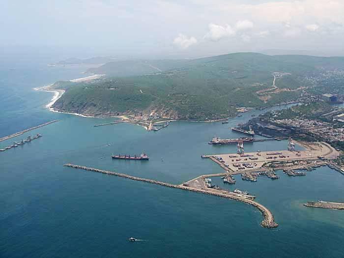
Andhra | [[File:Vizag Seaport aerial view.jpg|thumb|Aerial view of Vizag Sea Port|left]] | ||
[[File:Vijayawada Airport 12 (November 2018).jpg|thumb|Vijayawada Airport Terminal]] | |||
Coastal Andhra is well-connected by various modes of transportation, including air, rail, and road networks, playing a crucial role in the region's connectivity and economy. | |||
The region's railway infrastructure includes several major stations such as [[Vijayawada Junction railway station|Vijayawada railway station]], one of the busiest railway junctions in India, along with other key stations in [[Rajahmundry railway station|Rajahmundry]], [[Kakinada Town railway station|Kakinada Town]], [[Gudivada Junction railway station]], [[Narasapur railway station|Narsapuram]], [[Machilipatnam railway station|Machilipatnam]], [[Guntur Junction railway station|Guntur]], [[Tenali Junction railway station|Tenali]], [[Nellore railway station|Nellore]], and [[Repalle]]. Vijayawada serves as a central hub for numerous trains originating from and passing through the region.<ref>{{Cite web |title=Howrah to Vijayawada: Explore India's 7 busiest railway stations - Howrah Junction |url=https://economictimes.indiatimes.com/industry/transportation/railways/howrah-to-vijayawada-explore-indias-7-busiest-railway-stations/vijayawada-station/slideshow/114452681.cms |access-date=2024-11-10 |website=The Economic Times}}</ref> | |||
[[File: | In terms of road transport, [[Pandit Nehru Bus Station]] (PNBS) in Vijayawada is one of the largest bus terminals in the country, handling a high volume of passengers.<ref>{{Cite web |date=2024-04-30 |title=Biggest Bus Stand in India |url=https://www.abhibus.com/blog/biggest-bus-stand-in-india/ |access-date=2024-11-10 |website=AbhiBus |language=en-US}}</ref> Buses operate from various towns and cities in the region, further connecting the area with major destinations across Andhra Pradesh and beyond.[[File:KAKINADA STATION MAIN ENTRANCE.jpg|thumb|[[Kakinada Town railway station]] main entrance|220x220px]]Air connectivity is provided by [[Visakhapatnam Airport|Visakhapatnam International Airport]], [[Vijayawada Airport|Vijayawada International Airport]] and [[Rajahmundry Airport]], which serve both domestic and limited international flights. Additionally, [[Nellore Airport]] is currently under construction to enhance air travel access to the region. | ||
Coastal Andhra is also home to several major ports, vital for the region's trade and commerce. [[Kakinada Port]] is a significant seaport, while [[Visakhapatnam Port]] is one of the busiest cargo-handling ports in India.<ref name="IBTimes">{{Cite news |author1=Rama Mohan |date=13 July 2014 |title=AP to Set up Maritime Board to Develop Ports |url=http://www.ibtimes.co.in/ap-set-maritime-board-develop-ports-604320 |access-date=26 July 2014 |work= |publisher=International Business Times, India}}</ref> [[Krishnapatnam Port]] at [[Nellore]] is a major private port in the region,<ref name="thehindu">{{cite news |date=11 June 2012 |title=Chennai port loses out to new facility |url=http://www.thehindu.com/business/chennai-port-loses-out-to-new-facility/article3512758.ece |accessdate=22 November 2012 |newspaper=The Hindu}}</ref> and smaller ports such as [[Machilipatnam Port]] and [[Nizampatnam]] Port in Bapatla district further contribute to maritime trade.<ref>{{Cite web |title=Andhra Sea Ports - Nizampatnam |url=https://www.indianlogisticsinfo.com/logistics_directory/seaports/nizam_patnam.html |access-date=2024-11-10 |website=Indian Logistics Industry Directory}}</ref><ref>{{Cite web |last=Sridhar |first=G. Naga |date=2024-10-02 |title=Machilipatnam port will be completed by December 2025: AP CM |url=https://www.thehindubusinessline.com/news/machilipatnam-port-will-be-completed-by-december-2025-ap-cm/article68709641.ece |access-date=2024-11-10 |website=BusinessLine |language=en}}</ref> Andhra Pradesh is the second-busiest maritime state in India in terms of cargo handled, following [[Gujarat]].<ref>{{Cite news |author1=P.Manoj |date=10 May 2013 |title=Dugarajapatnam in Andhra Pradesh to have new major port |url=http://www.livemint.com/Politics/bOhk7gMjTCGnUqamWzNYAM/Dugarajapatnam-in-Andhra-Pradesh-to-have-new-major-port.html |access-date=26 July 2014 |work=Live Mint and The Wall Street Journal}}</ref> | |||
== Notable personalities == | == Notable personalities == | ||
'''National flag design''' | '''National flag design''' | ||
* [[Pingali Venkayya]] | * [[Pingali Venkayya]]<ref>{{Cite news |date=3 August 2022 |title=Pingali Venkayya, the man behind Tricolour, struggled to make ends meet and died penniless in 1963 |url=https://economictimes.indiatimes.com/magazines/panache/pingali-venkayya-the-man-behind-tricolour-struggled-to-make-ends-meet-died-penniless-in-1963/articleshow/93323828.cms |access-date=2022-08-10 |work=The Economic Times}}</ref> | ||
'''Singers''' | '''Singers''' | ||
* [[M. Balamuralikrishna| | * [[M. Balamuralikrishna]]<ref>{{cite news |date=1 March 2003 |title=Mangalampalli can't wait to come home |url=http://www.hindu.com/thehindu/2003/03/01/stories/2003030108610300.htm |url-status=dead |archive-url=https://web.archive.org/web/20050120002053/http://www.hindu.com/thehindu/2003/03/01/stories/2003030108610300.htm |archive-date=20 January 2005 |access-date=2 November 2012 |work=[[The Hindu]]}}</ref> | ||
* [[ | * [[P. B. Sreenivas|P. B. Srinivas]]<ref name="auto2">{{Cite web |date=14 April 2013 |title=Chennai: Legendary singer Dr P B Sreenivas no more |url=https://www.daijiworld.com/news/newsDisplay?newsID=170410 |website=Daijiworld}}</ref> | ||
* [[S Janaki]] | * [[S. P. Balasubrahmanyam]]<ref>{{Cite news |last=Murali |first=S. |date=25 September 2020 |title=S.P. Balasubrahmanyam: The end of an era |url=https://www.thehindu.com/entertainment/movies/sp-balasubrahmanyam-the-end-of-an-era/article32695994.ece |url-status=live |archive-url=https://web.archive.org/web/20200926020903/https://www.thehindu.com/entertainment/movies/sp-balasubrahmanyam-the-end-of-an-era/article32695994.ece |archive-date=26 September 2020 |access-date=25 September 2020 |work=The Hindu |language=en-IN |issn=0971-751X}}</ref> | ||
* [[P Susheela]] | * [[S. Janaki]]<ref>{{cite news |date=29 June 2007 |title=Timeless voice |url=http://www.hindu.com/fr/2007/06/29/stories/2007062950420200.htm |url-status=dead |archive-url=https://web.archive.org/web/20121108154101/http://www.hindu.com/fr/2007/06/29/stories/2007062950420200.htm |archive-date=8 November 2012 |work=[[The Hindu]] |location=Chennai, India}}</ref> | ||
* [[P. Susheela]]<ref>{{Cite web |title=Melody Queen P. Susheela |url=https://psusheela.org/links/sony_bio.html |access-date=2024-11-10 |website=psusheela.org}}</ref> | |||
'''Telugu literature, arts and cinema''' | '''Telugu literature, arts and cinema''' | ||
| Line 155: | Line 210: | ||
* [[Gurram Jashuva]] | * [[Gurram Jashuva]] | ||
* [[S. V. Ranga Rao]] | * [[S. V. Ranga Rao]] | ||
* [[Ghantasala ( | * [[Ghantasala (musician)|Ghantasala]] | ||
* [[Pingali Venkayya]] | * [[Pingali Venkayya]] | ||
* [[N. T. Rama Rao]] | * [[N. T. Rama Rao]] | ||
* [[Akkineni Nageswara Rao]] | * [[Akkineni Nageswara Rao]] | ||
* [[Krishna Ghattamaneni]] | * [[Krishna Ghattamaneni|Krishna]] | ||
* [[Chiranjeevi]] | * [[Chiranjeevi]] | ||
* [[Nandamuri Balakrishna]] | * [[Nandamuri Balakrishna]] | ||
* [[ | * [[Pawan Kalyan]] | ||
* [[Goparaju Ramachandra Rao]] | * [[Goparaju Ramachandra Rao]] | ||
* [[Prabhas]] | |||
* [[S. S. Rajamouli]] | * [[S. S. Rajamouli]] | ||
== See also == | == See also == | ||
* [[Northern Circars]] | |||
* [[Rayalaseema]] | * [[Rayalaseema]] | ||
* [[ | * [[Uttarandhra]] | ||
* [[List_of_districts_of_Andhra_Pradesh#Districts|List of districts of Andhra Pradesh by regions]] | |||
== References == | == References == | ||
| Line 182: | Line 237: | ||
{{Godavari basin}} | {{Godavari basin}} | ||
{{ | {{Wikivoyage|Southern Coast (Andhra Pradesh)}} | ||
[[Category:Coastal Andhra| ]] | [[Category:Coastal Andhra| ]] | ||
Latest revision as of 13:51, 15 March 2026
Coastal Andhra
Kōstā Āndhra | |
|---|---|
 Coastal Andhra region (old districts) highlighted in Andhra Pradesh | |
| Country |  India India |
| State |  Andhra Pradesh Andhra Pradesh |
| Districts |
|
| Largest city | |
| Major Cities | |
| Area | |
| • Total | 91,915 km2 (35,489 sq mi) |
| Population (2011)[2] | |
| • Total | 34,195,655 |
| Languages | |
| • Official | Telugu |
| Time zone | UTC+05:30 (IST) |
| Vehicle registration | AP05, AP06, AP07, AP08, AP16, AP18, AP26, AP27, AP37, AP39 |
| Largest airport | Visakhapatnam Airport |


_3.jpg)
Coastal Andhra, also known as Kosta Andhra (IAST: Kōstā Āndhra), is a geographic region in the Indian state of Andhra Pradesh, comprising the coastal districts of the state between the Eastern Ghats and the Bay of Bengal, from the northern border with Orissa to Rayalaseema in the south.[3] It includes major cities Visakhapatnam, Vijayawada and Guntur City as well as the state capital Amaravati and is recognized for its fertile lands, rich cultural heritage, and economic importance. Coastal Andhra plays a significant role in the state's agricultural output, particularly in rice and tobacco production, supported by abundant water resources from the Godavari, Krishna, and Penna rivers.[4][5]
While Coastal Andhra generally includes the districts along the Bay of Bengal, the Uttarandhra (Northern Andhra) area is sometimes regarded as distinct due to its unique cultural and historical background. Coastal Andhra shares borders with the Rayalaseema region of Andhra Pradesh and the state of Telangana. Covering an area of 91,915 square kilometres (35,489 sq mi), Coastal Andhra accounts for 58% of Andhra Pradesh's total area and, as per the 2011 Census of India, hosts a population of over 3.4 crore, constituting 69.20% of the state's population. Coastal Andhra was formerly part of the Madras State until 1953 and then became part of Andhra State from 1953 to 1956.[3]
Historically, Coastal Andhra has been a centre of trade and culture, featuring strong traditions in literature, music, and dance. The region contributed actively to the Indian independence movement and continues to impact the state's economy through industries such as information technology, petroleum, and pharmaceuticals. It is also home to major ports in Visakhapatnam and Kakinada, enhancing its status as a critical industrial and trading hub. Proximity to the Bay of Bengal, however, makes the region susceptible to tropical cyclones and coastal erosion, prompting investments in disaster preparedness and coastal management initiatives.[3]
History[edit | edit source]
The region of Andhra emerged as a prominent political power during the Maurya Empire. Historical accounts by Greek ambassador Megasthenes (c. 310 BCE) reference Andhra as a flourishing region under the Satavahanas before the Common Era.[6][7] The Satavahana dynasty dominated the Deccan Plateau from the 1st century BCE to the 3rd century CE.[8] It had trade relations with the Roman Empire.[9] The Satavahanas made Dhanyakataka-Amaravathi their capital. According to historian Stanley Wolpert, it might have been the most prosperous city in India in 2nd century CE.[10][11]
Coastal Andhra was subsequently governed by the Eastern Chalukya dynasty between the 7th and 12th centuries CE, followed by successive rule under the Chola, Kakatiya, Reddys and Vijayanagara empires.[12][13][14] According to 11th-century inscriptions, the geographical boundaries of Coastal Andhra extended from the Mahendragiri mountains in the northeastern border near Orissa's Gajapati district, to the Kalahasti Temple in Tirupati district, and the Srisailam Temple in Nandyal district.[15]
In the mid-18th century, the Gajapati and Ganjam districts, which were part of Coastal Andhra, were granted to the French East India Company in 1752 but were later transferred to British control. Nellore, including areas reaching up to Ongole Taluk, came under British administration after being acquired from the Nawab of Arcot. Additionally, certain parts of present-day Nellore and Chittoor were managed by the Venkatagiri Rajas until 1802, when the British entered into an arrangement with the Raja of Venkatagiri, consolidating their control over these territories.[16]
The Coastal Andhra districts, historically known as the Northern Circars, along with the Rayalaseema region, were ceded by the Nizam of Hyderabad to the British colonial administration, becoming part of the Madras Presidency under British rule.[17]
Geography[edit | edit source]
Coastal Andhra is situated in the eastern region of the Indian state of Andhra Pradesh, along the Circar Coast. It covers an area of 91,915 square kilometres (35,489 sq mi).[3] It comprises 20 districts: Srikakulam, Vizianagaram, Parvathipuram Manyam, Alluri Sitarama Raju,Polavaram, Visakhapatnam, Anakapalli, Kakinada, Konaseema, East Godavari, West Godavari, Eluru, Krishna, NTR, Guntur, Palnadu, Bapatla, Prakasam, Markapuram and Nellore.
The region borders the Rayalaseema region within Andhra Pradesh and shares boundaries with the state of Telangana. Fertile lands in Coastal Andhra are supported by the presence of three major rivers: the Godavari, Krishna, and Penna, which enhance agricultural productivity through extensive irrigation systems.[18]
The coastal length of this region spans approximately 974 km, making it the second-longest coastline in India.[18]
Demographics[edit | edit source]
According to the 2011 Census of India, Coastal Andhra has a total population of 34,195,655 constituting 69.20% of the state's population.[3]
The majority of the population in Coastal Andhra practices Hinduism, accounting for approximately 93% of the residents. The Christian community represents around 1.51% of the region's population.[19]
The primary language spoken across Coastal Andhra is Telugu.[20]
Culture[edit | edit source]
Kuchipudi is the classical dance form of the state, which was originated in the Kuchipudi village of Krishna district.[21]
Cuisine[edit | edit source]
Rice is the staple food in the coastal cuisine and is usually consumed with a variety of curries and lentil soups or broths. The cuisine of Coastal Andhra is influenced by various seafood varieties.[citation needed]
Politics[edit | edit source]
The Coastal Andhra region of Andhra Pradesh comprises 20 districts: Srikakulam, Vizianagaram, Parvathipuram Manyam, Polavarm, Alluri Sitharama Raju, Visakhapatnam, Anakapalli, Kakinada, Konaseema, East Godavari, West Godavari, Eluru, Krishna, NTR, Guntur, Palnadu, Bapatla, Prakasam, Markapuram and Nellore.[22]
Many Chief Ministers from the region have held office in Andhra Pradesh and Andhra State. They are:
- Tanguturi Prakasam Panthulu – 1st Chief Minister of Andhra State (Prakasam)
- Bezawada Gopala Reddy – 2nd Chief Minister of Andhra State (Nellore)
- Kasu Brahmananda Reddy – 5th Chief Minister of Andhra Pradesh (Palnadu)
- Bhavanam Venkatarami Reddy – 10th Chief Minister of Andhra Pradesh (Guntur)
- N. T. Rama Rao – 12th Chief Minister of Andhra Pradesh (Krishna)
- Nadendla Bhaskara Rao – 13th Chief Minister of Andhra Pradesh (Guntur)
- K. Rosaiah – 17th Chief Minister of Andhra Pradesh (Bapatla)
Cities and towns[edit | edit source]
Visakhapatnam, Vijayawada, Guntur, Nellore, Kakinada, Rajahmundry, Tuni and Eluru are prominent cities in the Coastal Andhra region. Other major urban centers include Gudivada, Tenali, Narasaraopeta, Bhimavaram, Machilipatnam, Ongole, and Tadepalligudem. Important towns in the area include Chirala, Amalapuram, Palakollu, Narasapuram, Kavali, Chilakaluripet, Kandukur, Bantumilli, Razole, Kaikalur, Gannavaram, Repalle, and Bapatla.
Visakhapatnam is the most populous city in the region, while Amaravati, serving as the state capital, is also situated within Coastal Andhra.
Tourism[edit | edit source]
Buddhist hub[edit | edit source]

Coastal Andhra is a prominent hub for Buddhist heritage in India, second only to the Gangetic plains of Bihar and Uttar Pradesh. The region holds numerous ancient Buddhist sites, featuring remnants of large monasteries, stupas, and other significant artifacts that span from Srikakulam district in the north to Nellore district in the south. Key sites include Amaravathi, Salihundam, Ramatheertham, Thotlakonda, Bavikonda, Bojjannakonda, Kummarilova,[23] Kodavali,[24] and Bhattiprolu. Excavations at Gudiwada village in Vizianagaram district for instance, uncovered an ancient stupa mound, reflecting the depth of Buddhist influence across the region.[25]
Rivers, lakes and wetlands[edit | edit source]
Coastal Andhra is also noted for its diverse landscapes of rivers, lakes, and wetlands. The region contains 259 coastal wetlands, covering approximately 18,552 square kilometers, including 88 man-made wetlands.[26] Kolleru Lake, a significant natural freshwater lake situated in West Godavari district, functions as a flood-balancing reservoir for the Godavari and Krishna rivers and supports up to 50,000 resident and migratory birds. Recognized as a wildlife sanctuary in 1999 under India's Wildlife Protection Act, Kolleru Lake was designated a Ramsar wetland of international importance in 2002.[27] Additionally, the Godavari River splits into distributaries such as the Gouthami, Vasishta, Vainatheya, and Vruddha Gouthami before reaching the Bay of Bengal, creating an intricate riverine landscape across Coastal Andhra.[28]
.jpg)


Transport[edit | edit source]

.jpg)
Coastal Andhra is well-connected by various modes of transportation, including air, rail, and road networks, playing a crucial role in the region's connectivity and economy.
The region's railway infrastructure includes several major stations such as Vijayawada railway station, one of the busiest railway junctions in India, along with other key stations in Rajahmundry, Kakinada Town, Gudivada Junction railway station, Narsapuram, Machilipatnam, Guntur, Tenali, Nellore, and Repalle. Vijayawada serves as a central hub for numerous trains originating from and passing through the region.[29]
In terms of road transport, Pandit Nehru Bus Station (PNBS) in Vijayawada is one of the largest bus terminals in the country, handling a high volume of passengers.[30] Buses operate from various towns and cities in the region, further connecting the area with major destinations across Andhra Pradesh and beyond.

Air connectivity is provided by Visakhapatnam International Airport, Vijayawada International Airport and Rajahmundry Airport, which serve both domestic and limited international flights. Additionally, Nellore Airport is currently under construction to enhance air travel access to the region.
Coastal Andhra is also home to several major ports, vital for the region's trade and commerce. Kakinada Port is a significant seaport, while Visakhapatnam Port is one of the busiest cargo-handling ports in India.[31] Krishnapatnam Port at Nellore is a major private port in the region,[32] and smaller ports such as Machilipatnam Port and Nizampatnam Port in Bapatla district further contribute to maritime trade.[33][34] Andhra Pradesh is the second-busiest maritime state in India in terms of cargo handled, following Gujarat.[35]
Notable personalities[edit | edit source]
National flag design
Singers
- M. Balamuralikrishna[37]
- P. B. Srinivas[38]
- S. P. Balasubrahmanyam[39]
- S. Janaki[40]
- P. Susheela[41]
Telugu literature, arts and cinema
- Nannayya
- Tikkana
- Tenali Ramakrishna
- Gurajada Apparao
- Kandukuri Veeresalingam
- Devulapalli Venkata Krishna Sastri
- Tripuraneni Ramaswamy Chowdary
- Gurram Jashuva
- S. V. Ranga Rao
- Ghantasala
- Pingali Venkayya
- N. T. Rama Rao
- Akkineni Nageswara Rao
- Krishna
- Chiranjeevi
- Nandamuri Balakrishna
- Pawan Kalyan
- Goparaju Ramachandra Rao
- Prabhas
- S. S. Rajamouli
See also[edit | edit source]
References[edit | edit source]
- ↑ "Andhra Pradesh Fact Sheet". mapsofindia.com.
- ↑ "Wayback Machine" (PDF). 12 November 2013. Archived from the original (PDF) on 12 November 2013. Retrieved 24 February 2023.
{{cite web}}: Cite uses generic title (help) - ↑ 3.0 3.1 3.2 3.3 3.4 Ojha, Shreya (November 2019). "Demographic Profile of Coastal Andhra Pradesh, India" (PDF). International Journal of Scientific & Engineering Research. 10 (11). ISSN 2229-5518.
- ↑ Rao, Desari Panduranga (1985). Trends in Indian Transport System: A Districtwise Study. Inter-India Publications. p. 158. ISBN 978-0-86590-701-0.
- ↑ "Indian States fish production" (PDF).
- ↑ V. D., Mahajan (2016). Ancient India. S. Chand Publishing. p. 297. ISBN 978-93-5253-132-5.
- ↑ "History of Andhra Pradesh". Government of Andhra Pradesh. Archived from the original on 16 July 2012. Retrieved 22 July 2012.
- ↑ Charles Higham (2009). Encyclopedia of ancient Asian civilizations. Infobase Publishing. p. 299. ISBN 978-1-4381-0996-1. Retrieved 6 March 2016.
- ↑ Dutt, Sukumar (1988). Buddhist monks and monasteries of India: Their history and their contribution to Indian culture. Motilal Banarsidass. p. 132. ISBN 978-81-20-80498-2. Retrieved 29 April 2024.
- ↑ "History of Amaravati" (PDF). crda.ap.gov.in. Government of AP. Archived (PDF) from the original on 19 May 2024. Retrieved 29 July 2024.
- ↑ Wolpert, Stanley A. (1989). A new history of India. Oxford University Press. pp. 75, 76. ISBN 978-0-19-505636-5.
Amaravati on the banks of the Krishna, which was later the southeast capital of the Satavahanas, flourished in its trade with Rome, Ceylon, and Southeast Asia, and may well have been the most prosperous city of India during the second century of the Christian era.
- ↑ "About Eastern Chalukyas – Official AP state government portal – AP state portal". Archived from the original on 17 June 2016. Retrieved 27 May 2016.
- ↑ For a map of their territory see: Schwartzberg, Joseph E. (1978). A Historical atlas of South Asia. Chicago: University of Chicago Press. p. 147, map XIV.3 (b). ISBN 0226742210.
- ↑ Durga Prasad, J. (1988). History of the Andhras up to 1565 A. D. (PDF). Guntur: P.G. Publisher. pp. 231–235. Archived from the original (PDF) on 22 April 2006. Retrieved 27 January 2007.
- ↑ Austin Cynthia Talbot Assistant Professor of History and Asian Studies University of Texas (23 August 2001). Precolonial India in Practice : Society, Region, and Identity in Medieval Andhra: Society, Region, and Identity in Medieval Andhra. Oxford University Press. pp. 36–. ISBN 978-0-19-803123-9.
- ↑ Alladi Jagannatha Sastri (1922). A family history of Venkatagiri Rajas. Addison Press, Madras. pp. 67. ISBN 9785519483643.
- ↑ "Andhra Pradesh – end of an era". Business Standard. Hyderabad. 30 July 2013. Retrieved 8 April 2016.
- ↑ 18.0 18.1 "Administrative and Geographic profile" (PDF). msmehyd.ap.nic.in. Archived from the original (PDF) on 11 September 2016. Retrieved 5 April 2017.
- ↑ "Census Reference Tables, C-Series Population by religious communities". Censusindia.gov.in.
- ↑ "AP Government Portal – Official Andhra Pradesh State Govt. Portal" (PDF). www.ap.gov.in. Archived from the original (PDF) on 3 June 2016. Retrieved 5 April 2017.
- ↑ "Art has to be nurtured to sustain". The Hindu. Retrieved 5 April 2017.
- ↑ "Districts of Coastal Andhra". mapsofindia. 19 April 2014.
- ↑ B.V.S. Bhaskar (16 February 2012). "Buddhist site found near Tuni". The Hindu. Retrieved 29 July 2013.
- ↑ K.N. Murali Sankar (29 November 2011). "ASI gets tough with encroachers". The Hindu. Retrieved 29 July 2013.
- ↑ B. Madhu Gopal (9 October 2012). "Evidence of Buddhist site found". The Hindu. Retrieved 7 September 2013.
- ↑ Wetlands of India report, ISRO
- ↑ "Kolleru Water Lake". Andhra Pradesh Tourism Development Corporation. Archived from the original on 20 August 2016. Retrieved 8 February 2018.
- ↑ "Godavari River". Encyclopædia Britannica. Retrieved 10 November 2024.
- ↑ "Howrah to Vijayawada: Explore India's 7 busiest railway stations - Howrah Junction". The Economic Times. Retrieved 10 November 2024.
- ↑ "Biggest Bus Stand in India". AbhiBus. 30 April 2024. Retrieved 10 November 2024.
- ↑ Rama Mohan (13 July 2014). "AP to Set up Maritime Board to Develop Ports". International Business Times, India. Retrieved 26 July 2014.
- ↑ "Chennai port loses out to new facility". The Hindu. 11 June 2012. Retrieved 22 November 2012.
- ↑ "Andhra Sea Ports - Nizampatnam". Indian Logistics Industry Directory. Retrieved 10 November 2024.
- ↑ Sridhar, G. Naga (2 October 2024). "Machilipatnam port will be completed by December 2025: AP CM". BusinessLine. Retrieved 10 November 2024.
- ↑ P.Manoj (10 May 2013). "Dugarajapatnam in Andhra Pradesh to have new major port". Live Mint and The Wall Street Journal. Retrieved 26 July 2014.
- ↑ "Pingali Venkayya, the man behind Tricolour, struggled to make ends meet and died penniless in 1963". The Economic Times. 3 August 2022. Retrieved 10 August 2022.
- ↑ "Mangalampalli can't wait to come home". The Hindu. 1 March 2003. Archived from the original on 20 January 2005. Retrieved 2 November 2012.
- ↑ "Chennai: Legendary singer Dr P B Sreenivas no more". Daijiworld. 14 April 2013.
- ↑ Murali, S. (25 September 2020). "S.P. Balasubrahmanyam: The end of an era". The Hindu. ISSN 0971-751X. Archived from the original on 26 September 2020. Retrieved 25 September 2020.
- ↑ "Timeless voice". The Hindu. Chennai, India. 29 June 2007. Archived from the original on 8 November 2012.
- ↑ "Melody Queen P. Susheela". psusheela.org. Retrieved 10 November 2024.


