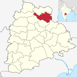
Mancherial district
Mancherial district | |
|---|---|
 | |
 Location of Mancherial district in Telangana | |
| Coordinates (Mancherial): 18°52′17″N 79°26′40″E / 18.871454°N 79.444361°ECoordinates: 18°52′17″N 79°26′40″E / 18.871454°N 79.444361°E | |
| Country | India |
| State | Telangana |
| Division | Mancherial |
| Headquarters | Mancherial |
| Tehsils | 18 |
| Government | |
| • District collector | Smt. Bharathi Hollikeri, IAS |
| • Lok Sabha constituencies | 01 |
| • Vidhan Sabha constituencies | 3 |
| Area | |
| • Total | 4,016 km2 (1,551 sq mi) |
| Population (2011) | |
| • Total | 807,037 |
| • Density | 200/km2 (520/sq mi) |
| • Urban | 76,641 |
| Time zone | UTC+05:30 (IST) |
| Vehicle registration | TS–19[1] |
| Major highways | NH 63 SH1Rajiv rahadari NH 363 |
| Website | mancherial |
Mancherial district is a district located in the northern region of the Indian state of Telangana.[2][3] The district comprises 18 mandals and two revenue divisions – Mancherial and Bellampalli. The district headquarters is located at Mancherial town.[4] It is surrounded by Komaram Bheem, Nirmal, Jagtial, Peddapalli and Bhupalpally districts of Telangana and with Maharashtra state.
History[edit]
Mancherial district was created out of Adilabad district in 2016 during the general reorganization of districts in Telangana.[5]
Administrative divisions[edit]
The district has two revenue divisions of Mancherial, Bellampally which are sub-divided into 18 mandals.[6] Smt. Bharathi Hollikeri, IAS is the present collector of the district.[7]
Mancherial District Revenue Divisions Mandals Information Lists [8]
| S. No. | Mancherial Revenue Division | S. No. | Bellampally Revenue Division |
|---|---|---|---|
| 1 | Chennur | 12 | Kasipet |
| 2 | Jaipur | 13 | Bellampally |
| 3 | Bheemaram (new) | 14 | Vemanpally |
| 4 | Kotapally | 15 | Nennel |
| 5 | Luxettipet | 16 | Tandur |
| 6 | Mancherial | 17 | Bheemini |
| 7 | Naspur (new) | 18 | Kannepally (new) |
| 8 | Hajipur (new) | ||
| 9 | Mandamarri | ||
| 10 | Dandepally | ||
| 11 | Jannaram |
Geography[edit]
The district is spread over an area of 4,056.36 square kilometres (1,566.17 sq mi).[9] It shares borders with Gadchiroli district of Maharashtra on the east, Jayashankar Bhupalpally, Peddapalli and Jagitial districts to the south, Nirmal district to the west and Kumaram Bheem district to the north.
The district is very fertile plains fed by the Godavari river, which forms the southern border of the district.
Demographics[edit]
As of 2011[update] Census of India, the district has a population of 807,037, with a ratio of 977 females to 1000 males.[9] The literacy rate is 64.35%. There are 148,377 farmers and 344,785 labourers. Scheduled Castes and Scheduled Tribes make up 24.71% and 7.06% of the population respectively.[10]
At the time of the 2011 census, 87.61% of the population spoke Telugu, 5.12% Urdu, 1.66% Lambadi, 1.49% Marathi and 1.44% Gondi as their first language.[11]
Transport[edit]
Mancherial is well connected with all types of transport facilities major are Road and Rail. Mancherial railway station is the train station with code: MCI.
TSRTC has its depot in Mancherial connecting transportation facility to the citizens to every village and city of Mancherial District.
See also[edit]
References[edit]
- ↑ "Telangana New Districts Names 2016 Pdf TS 31 Districts List". Timesalert.com. 11 October 2016. Retrieved 11 October 2016.
- ↑ "Komaram Bheem district" (PDF). Chief Commissioner of Land Administration. Archived from the original (PDF) on 9 September 2016. Retrieved 22 August 2016.
- ↑ "New districts map". newdistrictsformation.telangana.gov.in. Retrieved 22 August 2016.[permanent dead link]
- ↑ "Mancherial Official Page". The Official Website of the Mancherial District. Retrieved 3 March 2017.
- ↑ "Reorganization Of Adilabad District Into Mancherial District". www.districtsinfo.com. Retrieved 10 March 2017.
- ↑ "Clipping of Andhra Jyothy Telugu Daily – Hyderabad". Andhra Jyothy. Retrieved 8 October 2016.
- ↑ "K Chandrasekhar Rao appoints collectors for new districts". Deccan Chronicle. 11 October 2016. Retrieved 13 October 2016.
- ↑ "Mancherial Revenur Division and Mandals". Mancherial District Revenue Divisions Mandals Information. Retrieved 3 March 2017.
- ↑ 9.0 9.1 "New districts". Andhra Jyothy.com. 8 October 2016. Retrieved 8 October 2016.
- ↑ "Demography | Mancherial District | India". Retrieved 4 June 2021.
- ↑ 2011 Census of India, Population By Mother Tongue
