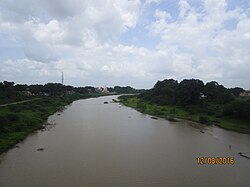
Shivana River
| Shivana River | |
|---|---|
 Shivana River | |
| Native name | (language?) |
| Location | |
| Country | India |
| State | Maharashtra |
| Region | Marathwada |
| District | Aurangabad |
| City | Kannad |
| Physical characteristics | |
| Source | Ajanta Range |
| • location | Gautala Wildlife Sanctuary, Aurangabad, Marathwada, Maharashtra, India |
| • coordinates | 20°33′N 75°19′E / 20.550°N 75.317°E |
| • elevation | 838 m (2,749 ft) |
| Mouth | Godavari River |
• location | NathSagar Reservoir, Aurangabad, Marathwada, Maharashtra |
• coordinates | 19°10′N 72°02′E / 19.167°N 72.033°ECoordinates: 19°10′N 72°02′E / 19.167°N 72.033°E |
• elevation | 351 m (1,152 ft) |
Shivana River is a minor but important tributary of Godavari lying entirely within Aurangabad district,[1] Maharashtra. It rises in the Kannad taluka,[2] from the south-western slope of the Ajanta Hills which also holds the origin to another major tributary Purna.
Origin[edit | edit source]
The river collects streams draining the Gautala Wildlife Sanctuary from the southern slopes of the Ajanta Hills.
Course[edit | edit source]
From the point of origin flows southeast for a short course till the town Kannad. Here the river is interrupted by presence of the Ambadi Dam.[3] The reservoir thus formed provides a water resource used for human consumption and is rich in fish diversity.[citation needed] From Kannad, the river flows in a south-eastern direction and is impounded by another dam known as the Shivana Takli Dam.[4] Upon reaching Jambarkheda, the river changes its course to flow south wards until Kate Pimpalgaon where it resumes the south-eastern course, ideal of most rivers of the Deccan Plateau. The river ends itself by merging seamlessly into the back waters of the NathSagar Reservoir formed by the Jayakwadi Dam on the river Godavari.It goes through Mandsaur district and touch the statue of Pashupatinath god in rainy season.
Dams[edit | edit source]
References[edit | edit source]
- ↑ "Aurangabad". National Informatics Centre. Archived from the original on 4 January 2014. Retrieved 23 June 2022.
- ↑ "Village Map, Taluka Kannad" (PDF). Maharashtra Remote Sensing Applications Centre. Retrieved 13 October 2015.
- ↑ "Ambadi Dam D01388". WRIS-Water Resources Information of India. Retrieved 13 October 2015.
- ↑ "Shivana Takli Dam D03058". WRIS-Water Resources Information of India. Retrieved 13 October 2015.


