




imported>Vatsmaxed m →top: replace, replaced: Indian road network → Roads in India |
General improvements and edits |
||
| Line 3: | Line 3: | ||
{{Use Indian English|date=February 2020}} | {{Use Indian English|date=February 2020}} | ||
{{Infobox settlement | {{Infobox settlement | ||
| name | | name = Mancherial district | ||
| settlement_type | | settlement_type = [[Districts of Telangana|District]] | ||
| total_type | | total_type = Total | ||
| image_skyline | | image_skyline = Yellampalli project.jpg | ||
| image_alt | | image_alt = | ||
| image_caption | | image_caption = [[Sripada Yellampalli project|Yellampelli project]] | ||
| image_map | | image_map = Mancherial in Telangana (India).svg | ||
| map_caption | | map_alt = | ||
| coordinates | | map_caption = Location in Telangana | ||
| coor_pinpoint | | coordinates = {{coord|18.871454|79.444361|display=inline,title}} | ||
| subdivision_type | | coor_pinpoint = Mancherial | ||
| subdivision_name | | subdivision_type = Country | ||
| subdivision_type1 | | subdivision_name = [[India]] | ||
| subdivision_name1 | | subdivision_type1 = [[States and union territories of India|State]] | ||
| subdivision_type2 | | subdivision_name1 = [[Telangana]] | ||
| subdivision_name2 | | subdivision_type2 = [[Administrative divisions of India|Division]] | ||
| established_title | | subdivision_name2 = Mancherial | ||
| established_date | | established_title = Established | ||
| seat_type | | established_date = | ||
| seat | | seat_type = Headquarters | ||
| parts_type | | seat = [[Mancherial]] | ||
| parts_style | | parts_type = [[List of mandals in Telangana|Mandalas]] | ||
| p1 | | parts_style = para | ||
| area_total_km2 | | p1 = 18 | ||
| area_footnotes | | area_total_km2 = 4016.46 | ||
| population_as_of | | area_footnotes = | ||
| population_total | | population_as_of = 2011 | ||
| population_footnotes | | population_total = 807037 | ||
| population_urban | | population_footnotes = <ref>{{Cite web |title=Mancherial (District, Telangana, India) - Population Statistics, Charts, Map and Location |url=https://www.citypopulation.de/en/india/admin/telangana/735__mancherial/ |access-date=2025-02-15 |website=www.citypopulation.de}}</ref> | ||
| population_density_km2 = | | population_urban = 366557 | ||
| demographics_type1 | | population_rural = 440481 | ||
| demographics1_title1 | | population_density_km2 = | ||
| demographics1_info1 | | population_density_sq_mi = 201 | ||
| demographics1_title2 | | population_demonym = Mancherialite | ||
| demographics1_info2 | | demographics_type1 = | ||
| leader_title | | demographics1_title1 = [[Literacy in India|Literacy]] | ||
| leader_name | | demographics1_info1 = | ||
| leader_title1 | | demographics1_title2 = Sex ratio | ||
| leader_name1 | | demographics1_info2 = | ||
| leader_title2 | | leader_title = [[District collector]] | ||
| | | leader_name = Sri. Kumar Deepak, IAS | ||
| timezone1 | | leader_title1 = [[List of constituencies of the Lok Sabha#Telangana (17)|Parliament Constituencies]] | ||
| utc_offset1 | | leader_name1 = [[Peddapalli Lok Sabha constituency|Peddapalli]] | ||
| registration_plate | | leader_title2 = [[List of constituencies of the Telangana Legislative Assembly|Assembly constituencies]] | ||
| blank_name_sec1 | | leader_name2 = [[Mancherial Assembly constituency|Mancherial]], [[Chennur Assembly constituency|Chennur]], [[Bellampalli Assembly constituency|Bellampalli]] | ||
| blank_info_sec1 | | leader_title3 = [[Member of Parliament, Lok Sabha|MP]] | ||
| | | leader_name3 = [[Vamsi Krishna Gaddam]] | ||
| | | timezone1 = [[Indian Standard Time|IST]] | ||
| website | | utc_offset1 = +05:30 | ||
| registration_plate = TG–19<ref>{{cite news|title=Telangana New Districts Names 2016 Pdf TS 31 Districts List|url=https://timesalert.com/telangana-new-districts-list/21462/|access-date=11 October 2016|work=Timesalert.com|date=11 October 2016}}</ref> | |||
| blank_name_sec1 = [[Roads in India|Major highways]] | |||
| blank_info_sec1 = NH 63, SH1 (Rajiv rahadari), NH 363, NH163G Mancherial- Vijayawada GFH | |||
| blank1_name_sec1 = Literacy rate | |||
| blank1_info_sec1 = 64.35% | |||
| website = {{URL|http://mancherial.telangana.gov.in/}} | |||
| leader_name4 = Ambar Kishor Jha(IPS) ([[Ramagundam Police Commissionerate]]) | |||
| leader_title4 = [[Commissioner of Police]] | |||
}} | }} | ||
'''Mancherial district''' is a district located in the northern region of the [[Indian state]] of [[Telangana]].<ref name="district">{{cite web|title=Komaram Bheem district|url=http://newdistrictsformation.telangana.gov.in/uploads/gos-circulars/1471856933317Final%20Adilabad.pdf|website=Chief Commissioner of Land Administration|access-date=22 August 2016|archive-url=https://web.archive.org/web/20160909190828/http://newdistrictsformation.telangana.gov.in/uploads/gos-circulars/1471856933317Final%20Adilabad.pdf|archive-date=2016-09-09|url-status=dead}}</ref><ref>{{cite web|title=New districts map|url=http://newdistrictsformation.telangana.gov.in/template1-assets/downloads/map.jpg|website=newdistrictsformation.telangana.gov.in|access-date=22 August 2016}}{{dead link|date=January 2018 |bot=InternetArchiveBot |fix-attempted=yes }}</ref> The district comprises 18 mandals and three revenue divisions – Mancherial, [[Chennur, Mancherial district|Chennur]] and [[Bellampalle|Bellampalli]]. [[Mancherial]] is the district headquarters.<ref>it is famous Home to a crocodile sanctuary and part of the Kawal Tiger Reserve, featuring dense forests.{{Cite web|url=http://mancherial.telangana.gov.in/district-profile/|title=Mancherial Official Page|website=The Official Website of the Mancherial District|access-date=3 March 2017}}</ref><ref>{{Cite web |last=Today |first=Telangana |date=2023-10-04 |title=Chennur is new revenue division |url=https://telanganatoday.com/chennur-is-new-revenue-division |access-date=2025-12-14 |website=Telangana Today |language=en}}</ref> It is surrounded by [[Komaram Bheem district|Komaram Bheem]], [[Nirmal district|Nirmal]], [[Jagtial district|Jagtial]], [[Peddapalli district|Peddapalli]] and [[Bhupalpally]] districts of Telangana and with [[Maharashtra|Maharashtra state]]. | |||
'''Mancherial district''' is a district located in the northern region of the [[Indian state]] of [[Telangana]]. | |||
== History == | ==History== | ||
Mancherial district was | |||
Mancherial district was formed from [[Adilabad district]] in 2016 as a part of reorganization of districts in Telangana.<ref name=":0">{{Cite web|url=http://www.districtsinfo.com/2016/11/mancherial-district-revenue-divisions.html|title=Reorganization Of Adilabad District Into Mancherial District|website=www.districtsinfo.com|access-date=10 March 2017}}</ref> | |||
== Administrative divisions == | == Administrative divisions == | ||
The district has | [[File:Mancherial District Revenue divisions.png|thumb|280px|Mancherial District Revenue divisions|left]] | ||
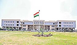
[[File:Integrated District Offices Complex Building, IDOC Mancherial.jpeg|thumb|IDOC building Mancherial]] | |||
The district has three [[List of revenue divisions in Telangana|revenue divisions]] of [[Mancherial]], [[Bellampally]], and [[Chennur, Mancherial district|Chennur]] which are sub-divided into 18 [[mandal]]s.<ref name="mandals">{{cite web|title=Clipping of Andhra Jyothy Telugu Daily – Hyderabad|url=http://epaper.andhrajyothy.com/c/13774805|website=Andhra Jyothy|access-date=8 October 2016|archive-date=9 October 2016|archive-url=https://web.archive.org/web/20161009185052/http://epaper.andhrajyothy.com/c/13774805|url-status=dead}}</ref> Sri. Kumar Deepak, IAS is the present collector of the district.<ref>{{cite news|title=K Chandrasekhar Rao appoints collectors for new districts|url=https://www.deccanchronicle.com/nation/current-affairs/111016/k-chandrasekhar-rao-appoints-collectors-for-new-districts.html|access-date=13 October 2016|work=Deccan Chronicle|date=11 October 2016}}</ref> | |||
Mancherial District Revenue Divisions Mandals Information List:<ref>{{Cite web |title=Mancherial Revenue Division and Mandals |url=http://www.districtsinfo.com/2016/11/mancherial-district-revenue-divisions.html |access-date=3 March 2017 |website=Mancherial District Revenue Divisions Mandals Information}}</ref> | |||
{| class="wikitable sortable mw-collapsible mw-collapsed" | |||
|+Mancherial District revenue mandals and information list: | |||
!Demographics Label | |||
!Value | |||
!Remarks | |||
|- | |||
|Number of revenue divisions | |||
|3 | |||
|Mancherial Bellampalli Chennur | |||
|- | |||
|No of revenue mandals | |||
|18 | |||
| | |||
|- | |||
|No of praja parishads | |||
|16 | |||
| | |||
|- | |||
|No of revenue villages | |||
|311 | |||
| | |||
|- | |||
|No of gram panchayats | |||
|382 | |||
| | |||
|- | |||
|No of municipalities | |||
|5 | |||
|[[Bellampalle]] [[Chennur, Mancherial district|Chennur]] [[Kyathanpally]] [[Luxettipet]] [[Mandamarri]] | |||
|- | |||
|No of municipal corporations | |||
|1 | |||
|[[Mancherial]] | |||
|} | |||
=== Revenue mandals === | |||
There are 18 mandals in District. | |||
{| class="wikitable" | {| class="wikitable" | ||
! | |||
!Chennur Revenue Division | |||
!Mancherial Revenue Division | !Mancherial Revenue Division | ||
!Bellampally Revenue Division | !Bellampally Revenue Division | ||
|- | |- | ||
|[[Chennur, Adilabad district|Chennur]] | |[[Chennur, Adilabad district|Chennur]] | ||
| | |[[Luxettipet]] | ||
|[[Kasipet]] | |[[Kasipet]] | ||
|- | |- | ||
|[[Jaipur mandal|Jaipur]] | |[[Jaipur mandal|Jaipur]] | ||
| | |[[Mancherial]] | ||
|[[Bellampalle|Bellampally]] | |[[Bellampalle|Bellampally]] | ||
|- | |- | ||
|[[Bheemaram]] (new) | |[[Bheemaram]] (new) | ||
| | |[[Naspur]] (new) | ||
|[[Vemanpalle, Adilabad district|Vemanpally]] | |[[Vemanpalle, Adilabad district|Vemanpally]] | ||
|- | |- | ||
|[[Kotapally]] | |[[Kotapally]] | ||
| | |[[Hajipur Mancherial District|Hajipur]] (new) | ||
|[[Nennal|Nennel]] | |[[Nennal|Nennel]] | ||
|- | |- | ||
| | |[[Mandamarri]] | ||
|[[ | |[[Dandepalle, Mancherial district|Dandepalle]] | ||
|[[Tandur, Adilabad district|Tandur]] | |[[Tandur, Adilabad district|Tandur]] | ||
|- | |- | ||
| | |[[Asnad]] (new) | ||
|[[ | |[[Jannaram]] | ||
|[[Bheemini]] | |[[Bheemini]] | ||
|- | |- | ||
|[[Parpally]] (new) | |||
|[[ | | | ||
| | |||
|[[Kannepally]] (new) | |[[Kannepally]] (new) | ||
|} | |} | ||
== Geography == | == Geography == | ||
The district is spread over an area of {{convert| | The district is spread over an area of {{convert|4016.46|km2|sqmi|abbr=unit}}.<ref>{{Cite web |title=Mancherial District {{!}} Government of Telangana {{!}} India |url=https://mancherial.telangana.gov.in/ |access-date=2025-12-14 |language=en-US}}</ref><ref name="newdist">{{cite news|url=http://www.andhrajyothy.com/artical?SID=320397|title=New districts|date=8 October 2016|work=Andhra Jyothy.com|access-date=8 October 2016|archive-date=25 December 2018|archive-url=https://web.archive.org/web/20181225064351/http://www.andhrajyothy.com/artical?SID=320397|url-status=dead}}</ref> It shares borders with [[Gadchiroli district]] of Maharashtra on the east, [[Jayashankar Bhupalpally district|Jayashankar Bhupalpally]], [[Peddapalli district|Peddapalli]] and [[Jagitial district|Jagitial]] districts to the south, Nirmal district to the west and [[Komaram Bheem Asifabad district|Kumaram Bheem Asifabad district]] to the north.<ref name=":1">{{Cite web |title=Map of District {{!}} Mancherial District {{!}} India |url=https://mancherial.telangana.gov.in/map-of-district/ |access-date=2025-12-14 |language=en-US}}</ref> | ||
The district is very fertile plains fed by the [[Godavari River|Godavari river]], which forms the southern border of the district. | The district is very fertile plains fed by the [[Godavari River|Godavari river]], which forms the southern border of the district.<ref name=":1" /> | ||
== Demographics == | == Demographics == | ||
{{ | |||
{{bar box | |||
| | |title=Religion in Mancherial district (2011)<ref name="Religion">{{cite web |title=Table C-01 Population By Religious Community: Andhra Pradesh|url=https://censusindia.gov.in/nada/index.php/catalog/11363/download/14476/DDW28C-01%20MDDS.XLS|website = censusindia.gov.in |publisher=[[Registrar General and Census Commissioner of India]]}}</ref> | ||
| | |titlebar=#fcd116 | ||
| | |float=right | ||
| | |bars= | ||
| | {{bar percent|[[Hinduism in Telangana|Hinduism]]|darkorange|92.55}} | ||
| | {{bar percent|[[Islam]]|green|5.58}} | ||
{{bar percent|[[Telugu Christians|Christianity]]|dodgerblue|0.98}} | |||
{{bar percent|Other or not stated|black|0.89}} | |||
}} | }} | ||
At the time of the 2011 census, | |||
{{As of|2011}} [[2011 census of India|Census of India]], the district has a population of 807,037.<ref>{{Cite web |date=2025 |title=Mancherial District-Demographics/Government of Telangana state |url=https://mancherial.telangana.gov.in/demography/ |website=Mancherial District demographic information}}</ref><ref>{{Cite web |title=Mancherial (District, Telangana, India) - Population Statistics, Charts, Map and Location |url=https://www.citypopulation.de/en/india/admin/telangana/735__mancherial/ |access-date=2025-02-15 |website=www.citypopulation.de}}</ref> Mancherial has a sex ratio of 977 females to 1000 males and a literacy rate of 64.35%. There are 148,377 farmers and 344,785 labourers. 73,725 (9.14%) were under 6 years of age. 353,847 (43.85%) lived in urban areas. Scheduled Castes and Scheduled Tribes make up 199,493 (24.72%) and 56,969 (7.06%) of the population respectively.<ref>{{Cite web |title=Know your district Plan your district - Mancherial |url=http://www.trac.telangana.gov.in/trac/New_Districts/districts/14-Mancherial.pdf |website=trac.telangana.gov.in |publisher=Telangana State Remote Sensing Applications Centre}}</ref><ref>{{Cite web|title=Demography {{!}} Mancherial District {{!}} India|url=https://mancherial.telangana.gov.in/demography/|access-date=2021-06-04|language=en-US}}</ref><ref>{{Cite web |title=Mancherial District Hand book |url=https://cdn.s3waas.gov.in/s33dd48ab31d016ffcbf3314df2b3cb9ce/uploads/2023/08/2023081641.pdf |website=Mancherial district Hand book}}</ref> | |||
{{Pie chart | |||
| thumb = right | |||
| caption = Languages of Mancherial district (2011)<ref name="language"/> | |||
| label1 = [[Telugu language|Telugu]] | |||
| value1 = 88.08 | |||
| color1 = steelblue | |||
| label2 = [[Urdu]] | |||
| value2 = 5.13 | |||
| color2 = green | |||
| label3 = [[Lambadi]] | |||
| value3 = 1.67 | |||
| color3 = khaki | |||
| label4 = [[Marathi language|Marathi]] | |||
| value4 = 1.60 | |||
| color4 = red | |||
| label5 = [[Gondi language|Gondi]] | |||
| value5 = 1.44 | |||
| color5 = darkturquoise | |||
| label6 = Others | |||
| value6 = 2.08 | |||
| color6 = grey | |||
}} | |||
At the time of the 2011 census, 88.08% of the population spoke [[Telugu language|Telugu]], 5.13% [[Urdu]], 1.67% [[Lambadi]], 1.60% [[Marathi language|Marathi]] and 1.44% [[Gondi language|Gondi]] as their first language.<ref name="language">{{Cite web |title=Table C-16 Population by Mother Tongue: Andhra Pradesh |url=https://censusindia.gov.in/nada/index.php/catalog/10193/download/13305/DDW-C16-STMT-MDDS-2800.XLSX |website=[[Census of India]] |publisher=[[Registrar General and Census Commissioner of India]]}}</ref> | |||
==Tourist places== | |||
<!---♦♦♦ Only add a place to this list if it already has its own article on the English Wikipedia ♦♦♦---> | |||
* [[Kawal Wildlife Sanctuary|Kawal Tiger Reserve]] is a nature preserve located at [[Jannaram]] mandal of Mancherial District | |||
* [[Pranahita Wildlife Sanctuary]]. Covers 136 square kilometres (53 sq mi) and is famous for Blackbuck, otherwise known as Indian antelope. | |||
* [[Shivaram Wildlife Sanctuary]] is a [[wildlife preserve]] in Mancherial district, located 10&nbsp;km from [[Manthani]], 40&nbsp;km from [[Peddapalli, Peddapalli district|Peddapalli]], 80&nbsp;km from [[Karimnagar]] and 30&nbsp;km from [[Godavarikhani]]. This [[riverine]] forest mixed with [[teak]] and [[Terminalia (plant)|terminalia]] is spread over {{convert|36.29|km2}} | |||
* [[Gudem Gutta Shree Satyanarayana Swamy Temple]], Gudem Village, in [[Dandepalle mandal]] Mancherial district. | |||
* [[Gadpur Jungle Safari]] is located in Gadpur Village, it is 2 km away from Mancherial. | |||
* [[Gandhari khilla]] is hill fort. It is located in the village of Bokkalagutta 4 km from Mancherial. | |||
* [[Singareni Thermal Power Plant]] located in Jaipur Mandal Mancherial District. | |||
== Industrial profile == | |||
[[File:Singareni Thermal Power Plant.jpg|thumb|Singareni Thermal Power Plant at [[Pegadapalli]]]] | |||
Mancherial district has a mix of large, small, and micro-scale industries. Major industries include coal, cement, thermal power plant, ceramic, rice mills and [[fly-ash]] bricks manufacturing. The district also has a limited presence of cotton-based industries.<ref>{{Cite web |date=2025 |title=Industries-Mancherial district |url=https://industries.telangana.gov.in/Library/DistrictNew/MANCHERIAL.pdf}}</ref> | |||
== Transport == | == Transport == | ||
TSRTC has its depot in Mancherial connecting transportation facility to the citizens to every village and city of Mancherial | [[Mancherial]] is well connected with all types of transport facilities major are Road and Rail. [[Mancherial railway station]] is the train station with code: MCI. | ||
List of important railway stations in mancherial district with railway station codes : | |||
* [[Bellampally railway station]] (BPA) | |||
* [[Mancherial railway station]] (MCI) | |||
[[Telangana State Road Transport Corporation]] (TSRTC )has its depot in Mancherial connecting transportation facility to the citizens to every village and city of Mancherial district. | |||
==Road== | |||
[[File:NH363 Mancherial Ring Road Interchange.jpg|thumb|NH363 Mncl Interchange]][[National Highway 63 (India)|NH 63]] Jagdalpur to yedashi via renapur latur bodhan nizamabad passes through Mancherial. | |||
[[National Highway 363 (India)|NH 363]] A new National highway is being constructed from Mancherial to Chandrapur. | |||
Also another new National highway is sanctioned from Jaipur Mandal to Warangal via Manthani and Bhupalpally. This Highway is named as Green Industrial corridor by NHAI. | |||
===Air=== | |||
Nearest airport is [[Hyderabad International Airport]] {{Convert|285|km|mi|abbr=unit}} away from the district headquarters [[Mancherial]] city. | |||
== Gallery == | |||
<gallery widths="130"> | |||
File:Kawal tiger reserve.jpg|The outer view of Reserve | |||
File:Gandhari Khilla arial view.jpg|Gandhari Khilla | |||
File:Drone footage of gadpur jungle safari JPG.jpg|Gadpur Jungle Safari | |||
File:Gudem Gutta.jpg|Gudem Gutta | |||
File:View of Rayapatnam Bridge over Godavari river from Gudem Gutta.jpg|View of Rayapatnam Bridge over Godavari river | |||
File:Mancherial station.png|Mancherial railway station | |||
File:NH363 Mancherial Ring Road Interchange.jpg|NH363 Interchange near Mancherial | |||
</gallery> | |||
== See also == | == See also == | ||
* [[List of districts in Telangana]] | * [[List of districts in Telangana]] | ||
* [[List of revenue divisions in Telangana]] | |||
* [[List of urban local bodies in Telangana]] | |||
* [[List of municipalities in Telangana]] | |||
* [[List of municipal corporations in Telangana|List of municipal corporationsTelangana]] | |||
== References == | == References == | ||
| Line 167: | Line 260: | ||
}} | }} | ||
{{Telangana | {{Telangana}}{{Mancherial district}}{{Godavari basin}} | ||
{{Authority control}} | |||
[[Category:Mancherial district| ]] | [[Category:Mancherial district| ]] | ||
[[Category:Districts of Telangana]] | [[Category:Districts of Telangana]] | ||
[[Category:Coal mining districts in India]] | |||
Revision as of 15:24, 17 February 2026
Mancherial district | |
|---|---|
 | |
.svg) Location in Telangana | |
| Coordinates (Mancherial): 18°52′17″N 79°26′40″E / 18.871454°N 79.444361°E | |
| Country | India |
| State | Telangana |
| Division | Mancherial |
| Headquarters | Mancherial |
| Mandalas | 18 |
| Government | |
| • District collector | Sri. Kumar Deepak, IAS |
| • Parliament Constituencies | Peddapalli |
| • Assembly constituencies | Mancherial, Chennur, Bellampalli |
| • MP | Vamsi Krishna Gaddam |
| • Commissioner of Police | Ambar Kishor Jha(IPS) (Ramagundam Police Commissionerate) |
| Area | |
| • Total | 4,016.46 km2 (1,550.76 sq mi) |
| Population (2011)<ref>"Mancherial (District, Telangana, India) - Population Statistics, Charts, Map and Location". www.citypopulation.de. Retrieved 15 February 2025.</ref> | |
| • Total | 807,037 |
| • Density | 78/km2 (201/sq mi) |
| • Urban | 366,557 |
| • Rural | 440,481 |
| Demonym | Mancherialite |
| Time zone | UTC+05:30 (IST) |
| Vehicle registration | TG–19<ref>"Telangana New Districts Names 2016 Pdf TS 31 Districts List". Timesalert.com. 11 October 2016. Retrieved 11 October 2016.</ref> |
| Major highways | NH 63, SH1 (Rajiv rahadari), NH 363, NH163G Mancherial- Vijayawada GFH |
| Literacy rate | 64.35% |
| Website | mancherial |
Mancherial district is a district located in the northern region of the Indian state of Telangana.<ref name="district">"Komaram Bheem district" (PDF). Chief Commissioner of Land Administration. Archived from the original (PDF) on 9 September 2016. Retrieved 22 August 2016.</ref><ref>"New districts map". newdistrictsformation.telangana.gov.in. Retrieved 22 August 2016.[permanent dead link]</ref> The district comprises 18 mandals and three revenue divisions – Mancherial, Chennur and Bellampalli. Mancherial is the district headquarters.<ref>it is famous Home to a crocodile sanctuary and part of the Kawal Tiger Reserve, featuring dense forests."Mancherial Official Page". The Official Website of the Mancherial District. Retrieved 3 March 2017.</ref><ref>Today, Telangana (4 October 2023). "Chennur is new revenue division". Telangana Today. Retrieved 14 December 2025.</ref> It is surrounded by Komaram Bheem, Nirmal, Jagtial, Peddapalli and Bhupalpally districts of Telangana and with Maharashtra state.
History
Mancherial district was formed from Adilabad district in 2016 as a part of reorganization of districts in Telangana.<ref name=":0">"Reorganization Of Adilabad District Into Mancherial District". www.districtsinfo.com. Retrieved 10 March 2017.</ref>
Administrative divisions


The district has three revenue divisions of Mancherial, Bellampally, and Chennur which are sub-divided into 18 mandals.<ref name="mandals">"Clipping of Andhra Jyothy Telugu Daily – Hyderabad". Andhra Jyothy. Archived from the original on 9 October 2016. Retrieved 8 October 2016.</ref> Sri. Kumar Deepak, IAS is the present collector of the district.<ref>"K Chandrasekhar Rao appoints collectors for new districts". Deccan Chronicle. 11 October 2016. Retrieved 13 October 2016.</ref>
Mancherial District Revenue Divisions Mandals Information List:<ref>"Mancherial Revenue Division and Mandals". Mancherial District Revenue Divisions Mandals Information. Retrieved 3 March 2017.</ref>
| Demographics Label | Value | Remarks |
|---|---|---|
| Number of revenue divisions | 3 | Mancherial Bellampalli Chennur |
| No of revenue mandals | 18 | |
| No of praja parishads | 16 | |
| No of revenue villages | 311 | |
| No of gram panchayats | 382 | |
| No of municipalities | 5 | Bellampalle Chennur Kyathanpally Luxettipet Mandamarri |
| No of municipal corporations | 1 | Mancherial |
Revenue mandals
There are 18 mandals in District.
| Chennur Revenue Division | Mancherial Revenue Division | Bellampally Revenue Division |
|---|---|---|
| Chennur | Luxettipet | Kasipet |
| Jaipur | Mancherial | Bellampally |
| Bheemaram (new) | Naspur (new) | Vemanpally |
| Kotapally | Hajipur (new) | Nennel |
| Mandamarri | Dandepalle | Tandur |
| Asnad (new) | Jannaram | Bheemini |
| Parpally (new) | Kannepally (new) |
Geography
The district is spread over an area of 4,016.46 km2 (1,550.76 sq mi).<ref>"Mancherial District | Government of Telangana | India". Retrieved 14 December 2025.</ref><ref name="newdist">"New districts". Andhra Jyothy.com. 8 October 2016. Archived from the original on 25 December 2018. Retrieved 8 October 2016.</ref> It shares borders with Gadchiroli district of Maharashtra on the east, Jayashankar Bhupalpally, Peddapalli and Jagitial districts to the south, Nirmal district to the west and Kumaram Bheem Asifabad district to the north.<ref name=":1">"Map of District | Mancherial District | India". Retrieved 14 December 2025.</ref>
The district is very fertile plains fed by the Godavari river, which forms the southern border of the district.<ref name=":1" />
Demographics
As of 2011[update] Census of India, the district has a population of 807,037.<ref>"Mancherial District-Demographics/Government of Telangana state". Mancherial District demographic information. 2025.</ref><ref>"Mancherial (District, Telangana, India) - Population Statistics, Charts, Map and Location". www.citypopulation.de. Retrieved 15 February 2025.</ref> Mancherial has a sex ratio of 977 females to 1000 males and a literacy rate of 64.35%. There are 148,377 farmers and 344,785 labourers. 73,725 (9.14%) were under 6 years of age. 353,847 (43.85%) lived in urban areas. Scheduled Castes and Scheduled Tribes make up 199,493 (24.72%) and 56,969 (7.06%) of the population respectively.<ref>"Know your district Plan your district - Mancherial" (PDF). trac.telangana.gov.in. Telangana State Remote Sensing Applications Centre.</ref><ref>"Demography | Mancherial District | India". Retrieved 4 June 2021.</ref><ref>"Mancherial District Hand book" (PDF). Mancherial district Hand book.</ref>
At the time of the 2011 census, 88.08% of the population spoke Telugu, 5.13% Urdu, 1.67% Lambadi, 1.60% Marathi and 1.44% Gondi as their first language.<ref name="language">"Table C-16 Population by Mother Tongue: Andhra Pradesh". Census of India. Registrar General and Census Commissioner of India.</ref>
Tourist places
<!---♦♦♦ Only add a place to this list if it already has its own article on the English Wikipedia ♦♦♦--->
- Kawal Tiger Reserve is a nature preserve located at Jannaram mandal of Mancherial District
- Pranahita Wildlife Sanctuary. Covers 136 square kilometres (53 sq mi) and is famous for Blackbuck, otherwise known as Indian antelope.
- Shivaram Wildlife Sanctuary is a wildlife preserve in Mancherial district, located 10 km from Manthani, 40 km from Peddapalli, 80 km from Karimnagar and 30 km from Godavarikhani. This riverine forest mixed with teak and terminalia is spread over 36.29 square kilometres (14.01 sq mi)
- Gudem Gutta Shree Satyanarayana Swamy Temple, Gudem Village, in Dandepalle mandal Mancherial district.
- Gadpur Jungle Safari is located in Gadpur Village, it is 2 km away from Mancherial.
- Gandhari khilla is hill fort. It is located in the village of Bokkalagutta 4 km from Mancherial.
- Singareni Thermal Power Plant located in Jaipur Mandal Mancherial District.
Industrial profile

Mancherial district has a mix of large, small, and micro-scale industries. Major industries include coal, cement, thermal power plant, ceramic, rice mills and fly-ash bricks manufacturing. The district also has a limited presence of cotton-based industries.<ref>"Industries-Mancherial district" (PDF). 2025.</ref>
Transport
Mancherial is well connected with all types of transport facilities major are Road and Rail. Mancherial railway station is the train station with code: MCI.
List of important railway stations in mancherial district with railway station codes :
Telangana State Road Transport Corporation (TSRTC )has its depot in Mancherial connecting transportation facility to the citizens to every village and city of Mancherial district.
Road

NH 63 Jagdalpur to yedashi via renapur latur bodhan nizamabad passes through Mancherial.
NH 363 A new National highway is being constructed from Mancherial to Chandrapur.
Also another new National highway is sanctioned from Jaipur Mandal to Warangal via Manthani and Bhupalpally. This Highway is named as Green Industrial corridor by NHAI.
Air
Nearest airport is Hyderabad International Airport 285 km (177 mi) away from the district headquarters Mancherial city.
Gallery
<gallery widths="130"> File:Kawal tiger reserve.jpg|The outer view of Reserve File:Gandhari Khilla arial view.jpg|Gandhari Khilla File:Drone footage of gadpur jungle safari JPG.jpg|Gadpur Jungle Safari File:Gudem Gutta.jpg|Gudem Gutta File:View of Rayapatnam Bridge over Godavari river from Gudem Gutta.jpg|View of Rayapatnam Bridge over Godavari river File:Mancherial station.png|Mancherial railway station File:NH363 Mancherial Ring Road Interchange.jpg|NH363 Interchange near Mancherial </gallery>
See also
- List of districts in Telangana
- List of revenue divisions in Telangana
- List of urban local bodies in Telangana
- List of municipalities in Telangana
- List of municipal corporationsTelangana
References
Places adjacent to Mancherial district | |
|---|---|


