


imported>C1MM Added religion bar chart |
Teena29I554 (talk | contribs) No edit summary |
||
| Line 2: | Line 2: | ||
{{Use Indian English|date=April 2017}} | {{Use Indian English|date=April 2017}} | ||
{{Infobox settlement | {{Infobox settlement | ||
| name | | name = Nagpur district | ||
| settlement_type | | settlement_type = [[List of districts of Maharashtra|District of Maharashtra]] | ||
| total_type | | total_type = Total | ||
| native_name | | native_name = | ||
| image_skyline | | image_skyline = {{Photomontage | ||
| | |size = 250 | ||
| | |photo1a = Deekshabhoomi, Nagpur in India.jpg | ||
| | |photo1b = Main Entrance of Nagardhan Fort (Inner View) - panoramio.jpg | ||
|photo2a = Stone circles of Junapani - panoramio.jpg | |||
|photo2b = Kalidas Memorial, Ramtek, India. - panoramio.jpg | |||
|photo3a = Ambhora nagpur district Vidharbha.jpeg | |||
| | |||
| | |||
| | |||
}} | }} | ||
'''Nagpur district''' (Marathi pronunciation: [[Help:IPA/Marathi|[ | | image_caption = Clockwise from top-left: [[Deekshabhoomi]], Nagardhan Fort, Kalidas Memorial at [[Ramtek]], Rivers at [[Ambhora]], [[Stone circles of Junapani]] | ||
| image_map = Nagpur in Maharashtra (India).svg | |||
| image_map1 = {{maplink |frame=yes | |||
|frame-width=225 |frame-height=225 |frame-align=center | |||
|text= '''Nagpur district''' | |||
|type=shape |id=Q1797367 | |||
|stroke-colour=#C60C30 | |||
|stroke-width=2 | |||
|title= Nagpur district of Maharashtra | |||
|type2=line|id2=Q1191|stroke-width2=1|stroke-colour2=#0000ff|title2=Maharashtra | |||
}} | |||
| map_alt = | |||
| map_caption = Location in Maharashtra | |||
| coordinates = {{coord|21|00|N|79|00|E|region:IN_type:adm2nd_source:GNS-enwiki|display=title,inline}} | |||
| coor_pinpoint = Nagpur | |||
| subdivision_type = Country | |||
| subdivision_name = {{flag|India}} | |||
| subdivision_type1 = [[States and union territories of India|State]] | |||
| subdivision_name1 = [[Maharashtra]] | |||
| subdivision_type2 = Division | |||
| subdivision_name2 = [[Nagpur division|Nagpur]] | |||
| established_title = Established | |||
| established_date = | |||
| seat_type = Headquarters | |||
| seat = [[Nagpur]] | |||
| parts_type = [[Tehsils of India|Tehsils]] | |||
| parts_style = para | |||
| p1 = 1. '''[[Ramtek]]''', 2. [[Umred]], 3. [[Kalameshwar]], 4. '''[[Katol]]''', 5. [[Kamptee taluka|Kamthi]], 6. [[Kuhi]], 7. [[Narkhed]], 8. '''[[Nagpur]]''', 9. Nagpur (Rural), 10. [[Parseoni]], 11. [[Bhiwapur]], 12. [[Mouda]], 13. [[Savner]], 14. [[Hingna]] | |||
| area_total_km2 = 9892 | |||
| area_footnotes = <ref>{{cite web|url=http://nagpur.nic.in |title=District Nagpur}}</ref> | |||
| population_as_of = 2011 | |||
| population_total = 4,653,570 | |||
| population_footnotes = | |||
| population_urban = 64.26% | |||
| population_density_km2 = auto | |||
| demographics_type1 = Demographics | |||
| demographics1_title1 = [[Literacy in India|Literacy]] | |||
| demographics1_info1 = 89.5% | |||
| demographics1_title2 = Sex ratio | |||
| demographics1_info2 = 948 | |||
| governing_body = | |||
| leader_title = Guardian Minister | |||
| leader_name = *'''[[Chandrashekhar Bawankule]]''' <br />{{small|([[Government of Maharashtra|Cabinet Minister]])}} | |||
| leader_title1 = Divisional Commissioner | |||
| leader_name1 = *'''Vijayalaxmi Bidari(IAS)''' | |||
| leader_title2 = District Collector | |||
| leader_name2 = *'''Dr.Vipin Itankar(IAS)''' | |||
| leader_title3 = District Council CEO | |||
| leader_name3 =*'''Vinayak Mahamuni(IAS)''' | |||
| leader_title4 = [[List of members of the 18th Lok Sabha|MPs]] | |||
| leader_name4 = *'''[[Nitin Gadkari]]'''<br /> {{small|([[Nagpur (Lok Sabha constituency)|Nagpur Lok Sabha]])}} | |||
*'''[[Shyamkumar Barve|Shyamkumar (Bablu) Barve]]'''<br /> {{small|([[Ramtek (Lok Sabha constituency)|Ramtek Lok Sabha]])}} | |||
| timezone1 = [[Indian Standard Time|IST]] | |||
| utc_offset1 = +05:30 | |||
| registration_plate = | |||
| blank_name_sec1 = | |||
| blank_info_sec1 = | |||
| blank_name_sec2 = [[Nominal gross domestic product]](Nagpur district) | |||
| blank_info_sec2 = [[Indian rupee|INR]] 1,81,665 [[crores]] (2022-2023) <ref>{{Cite web |title=Economic Survey of Maharashtra 2023-24 (Marathi) : Annexure 3.9 |url=https://mahades.maharashtra.gov.in/files/publication/ESM_2023_24_Mar_Book.pdf |access-date=2024-07-08}}</ref> | |||
| website = {{URL|https://nagpur.gov.in/}} | |||
| official_name = | |||
| blank1_name_sec1 = Average annual precipitation | |||
| blank1_info_sec1 = 1205 mm | |||
| blank1_name_sec2 = [[Per capita income]](Nagpur district) | |||
| blank1_info_sec2 = [[Indian rupee|INR]] 2,48,442 (2022-23) <ref>{{cite web |last1=Records |first1=Official |title=Per capita income Districts of Maharashtra 2019-20|url=https://mls.org.in|website=economy Department, Government of Maharashtra, India |publisher=Maharashtra Vidhanmanda}}</ref> | |||
}} | |||
'''Nagpur district''' (Marathi pronunciation: [[Help:IPA/Marathi|[naːɡpuːɾ]]]) is a [[Districts of Maharashtra|district]] in the [[Vidarbha]] region of [[Maharashtra]] state in central [[India]]. The city of [[Nagpur]] is the district administrative centre. The district is part of [[Nagpur Division]]. | |||
Nagpur district is bounded by [[Bhandara district]] on the east, [[Chandrapur district]] on the southeast, [[Wardha district]] on the southwest, [[Amravati district]] on the northwest and [[Chhindwara district]] of [[Madhya Pradesh]] state on the north. | Nagpur district is bounded by [[Bhandara district]] on the east, [[Chandrapur district]] on the southeast, [[Wardha district]] on the southwest, [[Amravati district]] on the northwest and [[Chhindwara district]] and [[Seoni district]] of [[Madhya Pradesh]] state on the north. | ||
==History== | ==History== | ||
In 1853, after the death of [[Nagpur kingdom#Raghoji III (1818–1853) | In 1853, after the death of [[Nagpur kingdom#Raghoji III Bhonsle (1818–1853)|Raghoji{{nbsp}}III]], the [[princely state]] of Nagpur was annexed by the British and the territory occupied by the present district became part of the then [[Nagpur Province]]. In 1861, it was merged with the [[Central Provinces]]. In 1903 it became part of the [[Central Provinces and Berar]]. In 1950 Nagpur district was created when it became part of the newly formed [[Madhya Pradesh]] state and Nagpur became its capital. In 1956, after a [[States Reorganisation Act|reorganisation of Indian states]], [[Nagpur]] district was incorporated into [[Bombay state]]. On 1{{nbsp}}May 1960, it became a district of Maharashtra state. | ||
==Geography== | ==Geography== | ||
| Line 156: | Line 183: | ||
==Divisions== | ==Divisions== | ||
Nagpur district is divided into 14 ''[[taluka]]s'': [[Ramtek]], [[Umred]], [[Kalameshwar]], [[Katol taluka|Katol]], [[Kamptee taluka| | Nagpur district is divided into 14 ''[[taluka]]s'': [[Ramtek]], [[Umred]], [[Kalameshwar]], [[Katol taluka|Katol]], [[Kamptee taluka|Kamptee]], [[Kuhi]], [[Narkhed taluka|Narkhed]], [[Nagpur]], [[Nagpur Rural]], [[Parseoni]], [[Bhiwapur]], [[Mauda|Mouda]], [[Saoner|Savner]] and [[Hingna]]. | ||
{| class="wikitable sortable" | {| class="wikitable sortable" | ||
|+ Sub-Divisions and ''Tahsils'' in Nagpur District | |+ Sub-Divisions and ''Tahsils'' in Nagpur District | ||
| Line 206: | Line 233: | ||
Nagpur district has 12 ''[[Maharashtra Vidhan Sabha|Vidhan Sabha]]'' constituencies: [[Nagpur South West (Vidhan Sabha constituency)|Nagpur South West]], [[Nagpur South (Vidhan Sabha constituency)|Nagpur South]], [[Nagpur East (Vidhan Sabha constituency)|Nagpur East]], [[Nagpur Central (Vidhan Sabha constituency)|Nagpur Central]], [[Nagpur West (Vidhan Sabha constituency)|Nagpur West]], [[Nagpur North (Vidhan Sabha constituency)|Nagpur North]], [[Katol (Vidhan Sabha constituency)|Katol]], [[Savner (Vidhan Sabha constituency)|Savner]], [[Hingna (Vidhan Sabha constituency)|Hingna]], [[Umred (Vidhan Sabha constituency)|Umred]], [[Kamthi (Vidhan Sabha constituency)|Kamthi]] and [[Ramtek (Vidhan Sabha constituency)|Ramtek]]. The first six constituencies are part of [[Nagpur (Lok Sabha constituency)|Nagpur Lok Sabha constituency]] and rest are part of [[Ramtek (Lok Sabha constituency)|Ramtek Lok Sabha constituency]].<ref name=ceo>{{cite web|url=http://ceo.maharashtra.gov.in/acs.php|title=District wise List of Assembly and Parliamentary Constituencies|publisher=Chief Electoral Officer, Maharashtra website|access-date=1 November 2010|url-status=dead|archive-url=https://web.archive.org/web/20100318055304/http://ceo.maharashtra.gov.in/acs.php|archive-date=18 March 2010|df=dmy-all}}</ref> | Nagpur district has 12 ''[[Maharashtra Vidhan Sabha|Vidhan Sabha]]'' constituencies: [[Nagpur South West (Vidhan Sabha constituency)|Nagpur South West]], [[Nagpur South (Vidhan Sabha constituency)|Nagpur South]], [[Nagpur East (Vidhan Sabha constituency)|Nagpur East]], [[Nagpur Central (Vidhan Sabha constituency)|Nagpur Central]], [[Nagpur West (Vidhan Sabha constituency)|Nagpur West]], [[Nagpur North (Vidhan Sabha constituency)|Nagpur North]], [[Katol (Vidhan Sabha constituency)|Katol]], [[Savner (Vidhan Sabha constituency)|Savner]], [[Hingna (Vidhan Sabha constituency)|Hingna]], [[Umred (Vidhan Sabha constituency)|Umred]], [[Kamthi (Vidhan Sabha constituency)|Kamthi]] and [[Ramtek (Vidhan Sabha constituency)|Ramtek]]. The first six constituencies are part of [[Nagpur (Lok Sabha constituency)|Nagpur Lok Sabha constituency]] and rest are part of [[Ramtek (Lok Sabha constituency)|Ramtek Lok Sabha constituency]].<ref name=ceo>{{cite web|url=http://ceo.maharashtra.gov.in/acs.php|title=District wise List of Assembly and Parliamentary Constituencies|publisher=Chief Electoral Officer, Maharashtra website|access-date=1 November 2010|url-status=dead|archive-url=https://web.archive.org/web/20100318055304/http://ceo.maharashtra.gov.in/acs.php|archive-date=18 March 2010|df=dmy-all}}</ref> | ||
== Administration == | |||
===Members of Parliament=== | |||
*'''[[Nitin Gadkari]]''' ([[Bharatiya Janata Party|BJP]])<br />{{small|([[Nagpur (Lok Sabha constituency)|Nagpur Lok Sabha]])}} | |||
*'''[[Shyamkumar Barve|Shyamkumar (Bablu) Barve]]''' ([[Indian National Congress|INC]])<br /> {{small|([[Ramtek (Lok Sabha constituency)|Ramtek Lok Sabha]])}} | |||
===Guardian Minister=== | |||
{{Infobox Political post | |||
| post = Guardian Minister Nagpur | |||
| insignia = Emblem_of_India.svg | |||
| insigniasize = 50px | |||
| insigniacaption = Emblem of India | |||
| image = | |||
| incumbent = [[Chandrashekhar Bawankule]] | |||
| incumbentsince = 18 January 2025 | |||
| style = [[The Honourable]] | |||
| imagesize = | |||
| termlength = 5 years / No time limit | |||
| appointer = [[Chief Minister of Maharashtra]] | |||
| residence = | |||
| formation = | |||
| succession = | |||
| website = {{URL|https://nagpur.gov.in//}} | |||
}} | |||
====List of Guardian Minister ==== | |||
{| class="wikitable" | |||
|- | |||
! Name | |||
! Term of office | |||
|- | |||
| '''[[Devendra Fadnavis]]''' | |||
|24 September 2022 - 26 November 2024 | |||
|- | |||
| '''[[Chandrashekhar Bawankule]]''' | |||
|18 January 2025 - Incumbent | |||
|} | |||
===District Magistrate/Collector=== | |||
* '''Dr.Vipin Itankar (IAS) (2018 - Incumbent)''' | |||
==Demographics== | ==Demographics== | ||
{{historical populations|11=1901|12=7,48,489|13=1911|14=8,06,287|15=1921|16=7,89,940|17=1931|18=9,36,987|19=1941|20=10,56,537|21=1951|22=12,30,535|23=1961|24=15,08,455|25=1971|26=19,42,688|27=1981|28=25,88,811|29=1991|30=32,87,139|31=2001|32=40,67,637|33=2011|34=46,53,570|percentages=pagr|footnote=source:<ref>[http://www.censusindia.gov.in/2011census/PCA/A2_Data_Table.html Decadal Variation In Population Since 1901]</ref>|align= | {{historical populations|11=1901|12=7,48,489|13=1911|14=8,06,287|15=1921|16=7,89,940|17=1931|18=9,36,987|19=1941|20=10,56,537|21=1951|22=12,30,535|23=1961|24=15,08,455|25=1971|26=19,42,688|27=1981|28=25,88,811|29=1991|30=32,87,139|31=2001|32=40,67,637|33=2011|34=46,53,570|percentages=pagr|footnote=source:<ref>[http://www.censusindia.gov.in/2011census/PCA/A2_Data_Table.html Decadal Variation In Population Since 1901]</ref>|align=center}} | ||
{{bar box | {{bar box | ||
|title=Religions in Nagpur district (2011)<ref name="Religion">{{ | |title=Religions in Nagpur district (2011)<ref name="Religion">{{Cite web|date=2011|title=Population by Religion - Maharashtra |url=https://censusindia.gov.in/nada/index.php/catalog/11382/download/14495/DDW27C-01%20MDDS.XLS |website=censusindia.gov.in|publisher=[[Registrar General and Census Commissioner of India]]}}</ref> | ||
|titlebar=#FCD116 | |titlebar=#FCD116 | ||
|left1=Religion | |left1=Religion | ||
| Line 218: | Line 288: | ||
|float=left | |float=left | ||
|bars= | |bars= | ||
{{bar percent|[[Hinduism in Maharashtra| | {{bar percent|[[Hinduism in Maharashtra|Hinduism]]|darkorange|75.04}} | ||
{{bar percent|[[Buddhism | {{bar percent|[[Marathi Buddhists|Buddhism]]|yellow|14.36}} | ||
{{bar percent|[[ | {{bar percent|[[Islam in Maharashtra|Islam]]|green|8.40}} | ||
{{bar percent|[[Christianity in Maharashtra| | {{bar percent|[[Christianity in Maharashtra|Christianity]]|dodgerblue|0.74}} | ||
{{bar percent|Other or not stated|black| | {{bar percent|[[Jainism in Maharashtra|Jainism]]|pink|0.53}} | ||
{{bar percent|[[Sikhism in Maharashtra|Sikhism]]|darkkhaki|0.44}} | |||
{{bar percent|Other or not stated|black|0.49}} | |||
}} | |||
According to the [[2011 census of India|2011 census]] Nagpur district had a [[Demographics of India|population]] of 4,653,570,<ref name="districtcensus">{{cite web |title=District Census Hand Book – Nagpur |url=https://censusindia.gov.in/nada/index.php/catalog/808/download/2882/DH_2011_2709_PART_A_DCHB_NAGPUR.pdf |website=[[Census of India]] |publisher=[[Registrar General and Census Commissioner of India]]}}</ref> roughly equal to the nation of [[Ireland]]<ref name="cia">{{cite web | author = US Directorate of Intelligence | title = Country Comparison:Population | url = https://www.cia.gov/library/publications/the-world-factbook/rankorder/2119rank.html | archive-url = https://web.archive.org/web/20070613004507/https://www.cia.gov/library/publications/the-world-factbook/rankorder/2119rank.html | url-status = dead | archive-date = 13 June 2007 | access-date = 2011-10-01 | quote =Ireland 4,670,976 July 2011 est. | |||
}}</ref> or the US state of [[South Carolina]].<ref>{{cite web|url=http://2010.census.gov/2010census/data/apportionment-pop-text.php|title=2010 Resident Population Data|publisher=U. S. Census Bureau|access-date=2011-09-30|quote=South Carolina 4,625,364|archive-date=27 December 2010|archive-url=https://archive.today/20101227010452/http://2010.census.gov/2010census/data/apportionment-pop-text.php|url-status=dead}}</ref> This gives it a ranking of 29th in India (out of a total of [[Districts of India|640]]).<ref name=districtcensus/> The district has a population density of {{convert| 470 |PD/sqkm|PD/sqmi}} .<ref name=districtcensus/> Its [[Family planning in India|population growth rate]] over the decade 2001–2011 was 14.39%.<ref name=districtcensus/> Nagpur has a [[sex ratio]] of 948 [[Women in India|females]] for every 1000 males,<ref name=districtcensus/> and a [[Literacy in India|literacy rate]] of 89.52%. 68.31% of the population live in urban areas. Scheduled Castes and Scheduled Tribes make up 18.65% and 9.40% of the population respectively.<ref name=districtcensus/> | |||
{| class="wikitable" | |||
! rowspan="2" |Year | |||
! rowspan="2" |Male | |||
! rowspan="2" |Female | |||
! rowspan="2" |Total Population | |||
! rowspan="2" |Change | |||
! colspan="8" |Religion (%) | |||
|- | |||
!Hindu | |||
!Muslim | |||
!Christian | |||
!Sikhs | |||
!Buddhist | |||
!Jain | |||
!Other religions and persuasions | |||
!Religion not stated | |||
|- | |||
|2001<ref>[https://censusindia.gov.in/nada/index.php/catalog/21494/download/24626/PC01_C01_27.xls Census India 2001].</ref> | |||
| style="text-align:right;" |2105314 | |||
| style="text-align:right;" |1962323 | |||
| style="text-align:right;" |4067637 | |||
| style="text-align:center;" | - | |||
| style="text-align:right;" |75.980 | |||
| style="text-align:right;" |7.294 | |||
| style="text-align:right;" |0.779 | |||
| style="text-align:right;" |0.483 | |||
| style="text-align:right;" |14.486 | |||
| style="text-align:right;" |0.556 | |||
| style="text-align:right;" |0.360 | |||
| style="text-align:right;" |0.063 | |||
|- | |||
|2011<ref>[https://censusindia.gov.in/nada/index.php/catalog/11382/download/14495/DDW27C-01%20MDDS.XLS Census India 2011].</ref> | |||
| style="text-align:right;" |2384975 | |||
| style="text-align:right;" |2268595 | |||
| style="text-align:right;" |4653570 | |||
| style="text-align:right;" |14.405 | |||
| style="text-align:right;" |75.044 | |||
| style="text-align:right;" |8.402 | |||
| style="text-align:right;" |0.745 | |||
| style="text-align:right;" |0.440 | |||
| style="text-align:right;" |14.356 | |||
| style="text-align:right;" |0.527 | |||
| style="text-align:right;" |0.262 | |||
| style="text-align:right;" |0.226 | |||
|} | |||
{{Pie chart | |||
|thumb = right | |||
|caption = Languages in Nagpur district (2011)<ref name="Language"/> | |||
|label1 = [[Marathi language|Marathi]] |value1 = 70.11 |color1 = red | |||
|label2 = [[Hindi]] |value2 = 17.71 |color2 = orange | |||
|label3 = [[Urdu]] |value3 = 4.20 |color3 = green | |||
|label4 = [[Chhattisgarhi language|Chhattisgarhi]] |value4 = 1.39 |color4 = peachpuff | |||
|label5 = [[Gondi language|Gondi]] |value5 = 1.09 |color5 = darkturquoise | |||
|label6 = [[Sindhi language|Sindhi]] |value6 = 0.97 |color6 = limegreen | |||
|label7 = Others |value7 = 4.53 |color7 = grey | |||
}} | }} | ||
At the time of the [[2011 Census of India]], 70.11% of the population spoke [[Marathi language|Marathi]], 17.71% [[Hindi]], 4.20% [[Urdu]], 1.39% [[Chhattisgarhi language|Chhattisgarhi]], 1.09% [[Gondi language|Gondi]] and 0.97% [[Sindhi language|Sindhi]] as their first language.<ref name="Language">{{cite web |title=Table C-16 Population By Mother Tongue: Maharashtra|url=https://censusindia.gov.in/nada/index.php/catalog/10212/download/13324/DDW-C16-STMT-MDDS-2700.XLSX|website=census.gov.in|date=2011|publisher=[[Registrar General and Census Commissioner of India]]}}</ref> | |||
=== Urban areas === | |||
The current [[District Collector]] is Abhishek Krishna. Nagpur district is made up of the following administrative bodies:<ref name="Planning Authority">{{cite web|url=http://www.nagpur.nic.in/tp/planningauthorities.htm|title=Planning Authority of Nagpur district|publisher=Government of Maharashtra|access-date=2009-01-08|url-status=dead|archive-url=https://web.archive.org/web/20090410072554/http://nagpur.nic.in/tp/planningauthorities.htm|archive-date=10 April 2009|df=dmy-all}}</ref> | |||
* [[Nagpur Municipal Corporation]] | * [[Nagpur Municipal Corporation]] | ||
* [[Nagpur Improvement Trust]] | * [[Nagpur Improvement Trust]] | ||
| Line 247: | Line 382: | ||
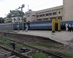
Due to its central location in India, the [[Nagpur Railway Station]] is an important [[Indian Railways|railway junction]]. It is a transit terminal for trains that connect the country lengthwise and breadthwise, especially trains connecting India's major metropolises, [[Mumbai]] to [[Howrah]]-[[Kolkata]], [[Delhi]] and [[Jammu]] to [[Chennai]], [[Hyderabad, India|Hyderabad]], [[Bangalore]] and [[Kanyakumari (town)|Kanyakumari]] in the South, as well as western cities such as [[Pune]] and [[Ahmedabad]].<ref name=index04052006>{{Cite news|url=http://www.indianexpress.com/story/3713.html|title=Nagpur stakes claim to lead boomtown pack|last=Deshpande|first=Vivek|work=The Indian Express|location=India|date=4 May 2006|access-date=22 June 2006|url-status=dead|archive-url=https://web.archive.org/web/20070929125003/http://www.indianexpress.com/story/3713.html|archive-date=29 September 2007|df=dmy-all}}</ref>[[File:Nagpur Railway Station.jpg|200px|thumb|Nagpur Junction]] | Due to its central location in India, the [[Nagpur Railway Station]] is an important [[Indian Railways|railway junction]]. It is a transit terminal for trains that connect the country lengthwise and breadthwise, especially trains connecting India's major metropolises, [[Mumbai]] to [[Howrah]]-[[Kolkata]], [[Delhi]] and [[Jammu]] to [[Chennai]], [[Hyderabad, India|Hyderabad]], [[Bangalore]] and [[Kanyakumari (town)|Kanyakumari]] in the South, as well as western cities such as [[Pune]] and [[Ahmedabad]].<ref name=index04052006>{{Cite news|url=http://www.indianexpress.com/story/3713.html|title=Nagpur stakes claim to lead boomtown pack|last=Deshpande|first=Vivek|work=The Indian Express|location=India|date=4 May 2006|access-date=22 June 2006|url-status=dead|archive-url=https://web.archive.org/web/20070929125003/http://www.indianexpress.com/story/3713.html|archive-date=29 September 2007|df=dmy-all}}</ref>[[File:Nagpur Railway Station.jpg|200px|thumb|Nagpur Junction]] | ||
Nagpur is also a major road junction as India's two major [[National highways of India|national highways]], [[Kanyakumari (town)|Kanyakumari]]-[[Varanasi]] ([[National Highway 7 (India | Nagpur is also a major road junction as India's two major [[National highways of India|national highways]], [[Kanyakumari (town)|Kanyakumari]]-[[Varanasi]] ([[National Highway 7 (India, old numbering)|NH{{nbsp}} 7]]) and [[Hazira|Hajira]]-Kolkata ([[National Highway 6 (India, old numbering)|NH{{nbsp}}6]]), pass through the city.<ref name=index04052006/> [[NH 69|Highway number{{nbsp}}69]] connects Nagpur to Obaidullaganj near [[Bhopal]]. Nagpur is at the junction of Asian HigLanka and [[AH46]] connecting [[Kharagpur, West Bengal|Kharagpur]] to [[Dhule]]. | ||
{{Further|Mumbai–Nagpur Expressway}} | {{Further|Mumbai–Nagpur Expressway}} | ||
The [[MSRTC]] buses run a cheap transport service in and around the district, reaching out to even the most remote areas of the district. | The [[MSRTC]] buses run a cheap transport service in and around the district, reaching out to even the most remote areas of the district. | ||
Latest revision as of 11:34, 18 January 2026
Nagpur district | |
|---|---|
 _-_panoramio.jpg)    Clockwise from top-left: Deekshabhoomi, Nagardhan Fort, Kalidas Memorial at Ramtek, Rivers at Ambhora, Stone circles of Junapani | |
.svg) Location in Maharashtra | |
| Coordinates (Nagpur): 21°00′N 79°00′E / 21.000°N 79.000°E | |
| Country |  India India |
| State | Maharashtra |
| Division | Nagpur |
| Headquarters | Nagpur |
| Tehsils | 1. Ramtek, 2. Umred, 3. Kalameshwar, 4. Katol, 5. Kamthi, 6. Kuhi, 7. Narkhed, 8. Nagpur, 9. Nagpur (Rural), 10. Parseoni, 11. Bhiwapur, 12. Mouda, 13. Savner, 14. Hingna |
| Government | |
| • Guardian Minister | (Cabinet Minister) |
| • Divisional Commissioner |
|
| • District Collector |
|
| • District Council CEO |
|
| • MPs | (Ramtek Lok Sabha) |
| Area | |
| • Total | 9,892 km2 (3,819 sq mi) |
| Population (2011) | |
| • Total | 4,653,570 |
| • Density | 470/km2 (1,200/sq mi) |
| • Urban | 64.26% |
| Demographics | |
| • Literacy | 89.5% |
| • Sex ratio | 948 |
| Time zone | UTC+05:30 (IST) |
| Average annual precipitation | 1205 mm |
| Nominal gross domestic product(Nagpur district) | INR 1,81,665 crores (2022-2023) [2] |
| Per capita income(Nagpur district) | INR 2,48,442 (2022-23) [3] |
| Website | nagpur |
Nagpur district (Marathi pronunciation: [naːɡpuːɾ]) is a district in the Vidarbha region of Maharashtra state in central India. The city of Nagpur is the district administrative centre. The district is part of Nagpur Division.
Nagpur district is bounded by Bhandara district on the east, Chandrapur district on the southeast, Wardha district on the southwest, Amravati district on the northwest and Chhindwara district and Seoni district of Madhya Pradesh state on the north.
History[edit | edit source]
In 1853, after the death of Raghoji III, the princely state of Nagpur was annexed by the British and the territory occupied by the present district became part of the then Nagpur Province. In 1861, it was merged with the Central Provinces. In 1903 it became part of the Central Provinces and Berar. In 1950 Nagpur district was created when it became part of the newly formed Madhya Pradesh state and Nagpur became its capital. In 1956, after a reorganisation of Indian states, Nagpur district was incorporated into Bombay state. On 1 May 1960, it became a district of Maharashtra state.
Geography[edit | edit source]

Climate[edit | edit source]
| Nagpur | ||||||||||||||||||||||||||||||||||||||||||||||||||||||||||||
|---|---|---|---|---|---|---|---|---|---|---|---|---|---|---|---|---|---|---|---|---|---|---|---|---|---|---|---|---|---|---|---|---|---|---|---|---|---|---|---|---|---|---|---|---|---|---|---|---|---|---|---|---|---|---|---|---|---|---|---|---|
| Climate chart (explanation) | ||||||||||||||||||||||||||||||||||||||||||||||||||||||||||||
| ||||||||||||||||||||||||||||||||||||||||||||||||||||||||||||
| ||||||||||||||||||||||||||||||||||||||||||||||||||||||||||||
| Climate data for Nagpur | |||||||||||||
|---|---|---|---|---|---|---|---|---|---|---|---|---|---|
| Month | Jan | Feb | Mar | Apr | May | Jun | Jul | Aug | Sep | Oct | Nov | Dec | Year |
| Record high °C (°F) | 33 (91) |
37 (99) |
41 (106) |
47 (117) |
49 (120) |
45 (113) |
38 (100) |
40 (104) |
39 (102) |
37 (99) |
35 (95) |
32 (90) |
49 (120) |
| Average high °C (°F) | 28.6 (83.5) |
32.1 (89.8) |
36.3 (97.3) |
40.2 (104.4) |
42.6 (108.7) |
37.8 (100.0) |
31.5 (88.7) |
30.4 (86.7) |
31.8 (89.2) |
32.6 (90.7) |
30.4 (86.7) |
28.2 (82.8) |
33.5 (92.3) |
| Average low °C (°F) | 12.4 (54.3) |
15.0 (59.0) |
19.0 (66.2) |
23.9 (75.0) |
27.9 (82.2) |
26.3 (79.3) |
24.1 (75.4) |
23.6 (74.5) |
22.9 (73.2) |
19.8 (67.6) |
14.9 (58.8) |
12.1 (53.8) |
20.2 (68.4) |
| Record low °C (°F) | 7 (45) |
8 (46) |
12 (54) |
17 (63) |
18 (64) |
20 (68) |
20 (68) |
20 (68) |
19 (66) |
11 (52) |
5 (41) |
3.5 (38.3) |
3.5 (38.3) |
| Average precipitation mm (inches) | 10.2 (0.40) |
12.3 (0.48) |
17.8 (0.70) |
13.2 (0.52) |
16.3 (0.64) |
172.2 (6.78) |
304.3 (11.98) |
291.6 (11.48) |
194.4 (7.65) |
51.4 (2.02) |
11.8 (0.46) |
17.2 (0.68) |
1,112.7 (43.81) |
| Source: [4] | |||||||||||||
Divisions[edit | edit source]
Nagpur district is divided into 14 talukas: Ramtek, Umred, Kalameshwar, Katol, Kamptee, Kuhi, Narkhed, Nagpur, Nagpur Rural, Parseoni, Bhiwapur, Mouda, Savner and Hingna.
| Sub-Division | Tahsils |
|---|---|
| Nagpur City |
|
| Nagpur Gramin |
|
| Kamptee |
|
| Umred |
|
| Ramtek |
|
| Saoner |
|
| Katol |
|
Nagpur district has 12 Vidhan Sabha constituencies: Nagpur South West, Nagpur South, Nagpur East, Nagpur Central, Nagpur West, Nagpur North, Katol, Savner, Hingna, Umred, Kamthi and Ramtek. The first six constituencies are part of Nagpur Lok Sabha constituency and rest are part of Ramtek Lok Sabha constituency.[5]
Administration[edit | edit source]
Members of Parliament[edit | edit source]
Guardian Minister[edit | edit source]
| Guardian Minister Nagpur | |
|---|---|
 Emblem of India | |
| Style | The Honourable |
| Appointer | Chief Minister of Maharashtra |
| Term length | 5 years / No time limit |
| Website | nagpur |
List of Guardian Minister[edit | edit source]
| Name | Term of office |
|---|---|
| Devendra Fadnavis | 24 September 2022 - 26 November 2024 |
| Chandrashekhar Bawankule | 18 January 2025 - Incumbent |
District Magistrate/Collector[edit | edit source]
- Dr.Vipin Itankar (IAS) (2018 - Incumbent)
Demographics[edit | edit source]
| Year | Pop. | ±% p.a. |
|---|---|---|
| 1901 | 748,489 | — |
| 1911 | 806,287 | +0.75% |
| 1921 | 789,940 | −0.20% |
| 1931 | 936,987 | +1.72% |
| 1941 | 1,056,537 | +1.21% |
| 1951 | 1,230,535 | +1.54% |
| 1961 | 1,508,455 | +2.06% |
| 1971 | 1,942,688 | +2.56% |
| 1981 | 2,588,811 | +2.91% |
| 1991 | 3,287,139 | +2.42% |
| 2001 | 4,067,637 | +2.15% |
| 2011 | 4,653,570 | +1.35% |
| source:[6] | ||
According to the 2011 census Nagpur district had a population of 4,653,570,[8] roughly equal to the nation of Ireland[9] or the US state of South Carolina.[10] This gives it a ranking of 29th in India (out of a total of 640).[8] The district has a population density of 470 inhabitants per square kilometre (1,200/sq mi) .[8] Its population growth rate over the decade 2001–2011 was 14.39%.[8] Nagpur has a sex ratio of 948 females for every 1000 males,[8] and a literacy rate of 89.52%. 68.31% of the population live in urban areas. Scheduled Castes and Scheduled Tribes make up 18.65% and 9.40% of the population respectively.[8]
| Year | Male | Female | Total Population | Change | Religion (%) | |||||||
|---|---|---|---|---|---|---|---|---|---|---|---|---|
| Hindu | Muslim | Christian | Sikhs | Buddhist | Jain | Other religions and persuasions | Religion not stated | |||||
| 2001[11] | 2105314 | 1962323 | 4067637 | - | 75.980 | 7.294 | 0.779 | 0.483 | 14.486 | 0.556 | 0.360 | 0.063 |
| 2011[12] | 2384975 | 2268595 | 4653570 | 14.405 | 75.044 | 8.402 | 0.745 | 0.440 | 14.356 | 0.527 | 0.262 | 0.226 |
At the time of the 2011 Census of India, 70.11% of the population spoke Marathi, 17.71% Hindi, 4.20% Urdu, 1.39% Chhattisgarhi, 1.09% Gondi and 0.97% Sindhi as their first language.[13]
Urban areas[edit | edit source]
The current District Collector is Abhishek Krishna. Nagpur district is made up of the following administrative bodies:[14]
- Nagpur Municipal Corporation
- Nagpur Improvement Trust
- Narkhed Municipal Council
- Katol Municipal Council
- Saoner Municipal Council
- Ramtek Municipal Council
- Mowad Municipal Council
- Khapa Municipal Council
- Umred Municipal Council
- Narkhed Municipal Council
- Kalmeshwar Municipal Council
- Kamptee municipal Council
Transport[edit | edit source]


Due to its central location in India, the Nagpur Railway Station is an important railway junction. It is a transit terminal for trains that connect the country lengthwise and breadthwise, especially trains connecting India's major metropolises, Mumbai to Howrah-Kolkata, Delhi and Jammu to Chennai, Hyderabad, Bangalore and Kanyakumari in the South, as well as western cities such as Pune and Ahmedabad.[15]

Nagpur is also a major road junction as India's two major national highways, Kanyakumari-Varanasi (NH 7) and Hajira-Kolkata (NH 6), pass through the city.[15] Highway number 69 connects Nagpur to Obaidullaganj near Bhopal. Nagpur is at the junction of Asian HigLanka and AH46 connecting Kharagpur to Dhule.
The MSRTC buses run a cheap transport service in and around the district, reaching out to even the most remote areas of the district.
Dr. Babasaheb Ambedkar International Airport in Sonegaon, Nagpur, is a domestic and international airport, which connects Nagpur to Mumbai, Delhi, Sharjah, Dubai and Muscat via Doha .
References[edit | edit source]
- ↑ "District Nagpur".
- ↑ "Economic Survey of Maharashtra 2023-24 (Marathi) : Annexure 3.9" (PDF). Retrieved 8 July 2024.
- ↑ Records, Official. "Per capita income Districts of Maharashtra 2019-20". economy Department, Government of Maharashtra, India. Maharashtra Vidhanmanda.
- ↑ "Nagpur, India". Whetherbase. Retrieved 1 July 2010.
- ↑ "District wise List of Assembly and Parliamentary Constituencies". Chief Electoral Officer, Maharashtra website. Archived from the original on 18 March 2010. Retrieved 1 November 2010.
- ↑ Decadal Variation In Population Since 1901
- ↑ "Population by Religion - Maharashtra". censusindia.gov.in. Registrar General and Census Commissioner of India. 2011.
- ↑ 8.0 8.1 8.2 8.3 8.4 8.5 "District Census Hand Book – Nagpur" (PDF). Census of India. Registrar General and Census Commissioner of India.
- ↑ US Directorate of Intelligence. "Country Comparison:Population". Archived from the original on 13 June 2007. Retrieved 1 October 2011.
Ireland 4,670,976 July 2011 est.
- ↑ "2010 Resident Population Data". U. S. Census Bureau. Retrieved 30 September 2011.
South Carolina 4,625,364
{{cite web}}: CS1 maint: deprecated archival service (link) - ↑ Census India 2001.
- ↑ Census India 2011.
- ↑ 13.0 13.1 "Table C-16 Population By Mother Tongue: Maharashtra". census.gov.in. Registrar General and Census Commissioner of India. 2011.
- ↑ "Planning Authority of Nagpur district". Government of Maharashtra. Archived from the original on 10 April 2009. Retrieved 8 January 2009.
- ↑ 15.0 15.1 Deshpande, Vivek (4 May 2006). "Nagpur stakes claim to lead boomtown pack". The Indian Express. India. Archived from the original on 29 September 2007. Retrieved 22 June 2006.
External links[edit | edit source]
Places adjacent to Nagpur district | |
|---|---|


| History | | ||||||||||||
|---|---|---|---|---|---|---|---|---|---|---|---|---|---|
| Geography | |||||||||||||
| Cities and towns | |||||||||||||
| Villages | |||||||||||||
| Monuments | |||||||||||||
| Education |
| ||||||||||||
| Transport |
| ||||||||||||
| Constituencies |
| ||||||||||||
| Districts of Vidarbha | |
|---|---|
| Cities with municipal corporations | |
| Topics | |||||||||||||
|---|---|---|---|---|---|---|---|---|---|---|---|---|---|
| Regions | |||||||||||||
| Divisions and Districts |
| ||||||||||||
| Million-plus cities in Maharashtra | |||||||||||||
| Other cities with municipal corporations | |||||||||||||


