



m expanded content |
|||
| Line 1: | Line 1: | ||
{{ | {{Short description|none}} | ||
{{Use dmy dates|date=March 2020}} | {{Use dmy dates|date=March 2020}} | ||
{{Use Indian English|date=March 2020}} | {{Use Indian English|date=March 2020}} | ||
There are 44 major rivers in [[Kerala]], all but three originating in the [[Western Ghats]] | There are 44 major rivers in [[Kerala]], all but three originating in the [[Western Ghats]], with 41 flowing westward and three eastward. The rivers of Kerala are small, in terms of length, breadth and water [[discharge (hydrology)|discharge]]. The rivers flow faster, owing to the hilly terrain and as the short distance between the Western Ghats and the sea. All the rivers are entirely monsoon-fed and half of them shrink into rivulets or dry up completely during summer but the major rivers flow perennial and plays an important role in the landscape of Kerala. | ||
==Features== | ==Features== | ||
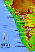
[[File:Topography of Kerala.png|thumb|Topography of Kerala]] | [[File:Topography of Kerala.png|thumb|Topography of Kerala]] | ||
Kerala is wedged between the [[Lakshadweep Sea]] and the [[Western Ghats]]. Geographically, the state can be divided into three climatically distinct regions: the eastern highlands; rugged and cool mountainous terrain, the central mid-lands; rolling hills, and the western lowlands; coastal plains.<ref name="ChattopadhyayFranke2006">{{cite book |author1=Srikumar Chattopadhyay |author2=Richard W. Franke |title=Striving for Sustainability: Environmental Stress and Democratic Initiatives in Kerala |url=https://books.google.com/books?id=gOrvghLklKoC&pg=PA110 |access-date=19 March 2019 |year=2006 |isbn=978-8180692949}}</ref>{{rp|110}} The eastern region of Kerala consists of high mountains, gorges and deep-cut valleys immediately west of the Western Ghats' [[rain shadow]].<ref name=ChattopadhyayFranke2006/>{{rp|110}} | Kerala is wedged between the [[Lakshadweep Sea]] and the [[Western Ghats]]. Geographically, the state can be divided into three climatically distinct regions: the eastern highlands; rugged and cool mountainous terrain, the central mid-lands; rolling hills, and the western lowlands; coastal plains.<ref name="ChattopadhyayFranke2006">{{cite book |author1=Srikumar Chattopadhyay |author2=Richard W. Franke |title=Striving for Sustainability: Environmental Stress and Democratic Initiatives in Kerala |url=https://books.google.com/books?id=gOrvghLklKoC&pg=PA110 |access-date=19 March 2019 |year=2006 |publisher=Concept Publishing Company |isbn=978-8180692949}}</ref>{{rp|110}} The eastern region of Kerala consists of high mountains, gorges and deep-cut valleys immediately west of the Western Ghats' [[rain shadow]].<ref name=ChattopadhyayFranke2006/>{{rp|110}} Forty-one of Kerala's west-flowing rivers,<ref name="Sadasivan2003">{{cite book |author=S. N. Sadasivan |title=River Disputes in India: Kerala Rivers Under Siege |url=https://books.google.com/books?id=hhrRboi5kOcC&pg=PA223 |access-date=18 November 2012 |year=2003 |publisher=Mittal Publications |isbn=978-8170999133 |page=223}}</ref> and three of its east-flowing ones originate in this region.<ref name="Darpan2006">{{cite book |author=Pratiyogita Darpan |title=Pratiyogita Darpan |url=https://books.google.com/books?id=QegDAAAAMBAJ&pg=PT72 |access-date=18 November 2012 |date=September 2006 |publisher=Pratiyogita Darpan |page=72}}</ref><ref name="India2008">{{cite book |author=Motilal (UK) Books of India |title=Tourist Guide Kerala |url=https://books.google.com/books?id=ZYfRBcLdTNYC&pg=PA11 |access-date=18 November 2012 |year= 2008 |publisher=Sura Books |isbn=978-8174781642 |page=11}}</ref> The 41 west-flowing rivers, each of which having at least a length of 15 km, gradually slopes towards the [[Arabian Sea]] coast in the western region and empty either into [[Kerala Backwaters|backwaters]] or [[Arabian Sea]] there.{{sfn|Chandran|2018|p=341}} The longer rivers have several tributaries and streams too.{{sfn|Chandran|2018|p=341}} The Western Ghats form a wall of mountains interrupted only near [[Palakkad]]; hence also known Pal''ghat'', where the [[Palakkad Gap]] breaks.<ref>{{cite web |last1=Chandran Nair |first1=Dr.S.Sathis |title=India – Silent Valley Rainforest Under Threat Once More |url=http://www.rainforestinfo.org.au/wrr2004/silentvalley.htm |website=rainforestinfo.org.au |access-date=12 November 2015}}</ref> The river [[Bharathappuzha]] flows through the [[Palakkad Gap]]. The three east-flowing rivers also originate in [[Western Ghats]], but flow eastwards either into [[Karnataka]] or [[Tamil Nadu]].{{sfn|Chandran|2018|p=341}} | ||
Kerala's western coastal belt is relatively flat compared to the eastern region, and is criss-crossed by a network of interconnected [[brackish]] canals, lakes, [[estuaries]],<ref name="Moss2010">{{cite book |author=Danny Moss |title=Public Relations Cases: International Perspectives |url=https://books.google.com/books?id=s0-CJ3djEdEC&pg=PA41 |access-date=18 November 2012 |year= 2010 |publisher=Taylor & Francis |isbn=978-0415773362 |page=41}}</ref> and rivers known as the [[Kerala Backwaters]].<ref name="Thorpe2012">{{cite book |author=Edgar Thorpe |title=The Pearson CSAT Manual 2012 |url=https://books.google.com/books?id=1cruroSVFoUC&pg=RA3-PA38 |access-date=18 November 2012 |year=2012 |publisher=Pearson Education India |isbn=978-8131767344 |page=3}}</ref> [[Kuttanad]], also known as ''The Rice Bowl of Kerala'', has the [[List of extreme points of India#Altitudes|lowest altitude in India]], and is also one of the few places in world where cultivation takes place below sea level.<ref>{{Cite news|title=Kerala Boat Ferries Lone Passenger To Help Her Take Exam|url=https://www.ndtv.com/kerala-news/coronavirus-lockdown4-kerala-government-boat-ferries-lone-passenger-sandra-babu-to-help-her-take-exam-2238752|last=Press Trust of India|date=1 June 2020|access-date=17 November 2020|work=NDTV}}</ref><ref>{{Cite web|url=http://www.hindu.com/mag/2003/07/13/stories/2003071300600200.htm|title=Thirst below sea level|last=Suchitra|first=M|date=2003-08-13|work=[[The Hindu]]|access-date=2020-11-17|archive-url=https://web.archive.org/web/20190922101804/https://www.thehindu.com/todays-paper/tp-features/tp-sundaymagazine/thirst-below-sea-level/article28523147.ece |archive-date=2019-09-22}}</ref> The country's longest lake [[Vembanad Lake|Vembanad]], dominates the backwaters; it lies between [[Alappuzha]] and [[Kochi]] and is about {{convert|200|km2|sqmi|abbr=on}} in area.<ref name="Husain">{{cite book |author=Majid Husain |author-link=Majid Husain |title=Understanding: Geographical: Map Entries: for Civil Services Examinations: Second Edition |url=https://books.google.com/books?id=_9VGKfQ-sQsC&pg=RA9-PT18 |access-date=18 November 2012 |publisher=Tata McGraw-Hill Education |isbn=978-0070702882 |page=9 |year=2011}}</ref> Around eight percent of India's waterways are found in Kerala.<ref name="IWAI_2005">{{Cite journal |author=Inland Waterways Authority of India (IWAI—Ministry of Shipping) |year=2005 |title=Introduction to Inland Water Transport |journal=IWAI (Ministry of Shipping) |url=http://iwai.nic.in/Introduction.html |archive-url=https://archive.today/20050204175110/http://iwai.nic.in/Introduction.html |url-status=dead |archive-date=4 February 2005 |access-date=19 January 2006}}</ref> Kerala's [[List of rivers in Kerala|44 rivers]] include the [[Periyar River|Periyar]]; {{convert|244|km|mi|0}}, [[Bharathapuzha]]; {{convert|209|km|mi|0}}, [[Pamba River|Pamba]]; {{convert|176|km|mi|0}}, [[Chaliyar River|Chaliyar]]; {{convert|169|km|mi|0}}, [[Chalakudy River|Chalakudypuzha]]; {{convert|145.5|km|mi|0}}, [[Kadalundipuzha River|Kadalundipuzha]]; {{convert|130|km|mi|0}}, [[Valapattanam River|Valapattanam]]; {{convert|129|km|mi|0}} and the [[Achankovil River]]; {{convert|128|km|mi|0}}. The average length of the rivers is {{convert|64|km|mi|0}}. Many of the rivers are small and entirely fed by monsoon rain.<ref name=riverreport>{{cite book |last=India. |first=Planning Commission |title=Kerala Development Report |year=2008 |publisher=Academic Foundation |isbn=978-8171885947 |page=224 |url=https://books.google.com/books?isbn=8171885942}}</ref> As Kerala's rivers are small and lacking in [[river delta|delta]], they are more prone to environmental effects. The rivers face problems such as sand mining and pollution.<ref name="Padmalal">Padmalal D, Maya K, Sreebha S & Sreeja R, (2007), "Environmental effects of river sand mining: a case from the river catchments of [[Vembanad lake]], Southwest coast of India", ''Environmental Geology'' 54(4), 879–89. [https://doi.org/10.1007/s00254-007-0870-z springerlink.com]. Retrieved 17 July 2009.</ref> | |||
[[File:Athirappilly Waterfalls after the Monsoons.jpg|thumb|center|The famous [[Athirapally Falls]] which sits on the [[Chalakudy River]] is an example for a river that transitions from the Mountainous Highlands to the Plainer Midlands via rapids and waterfalls ]] | |||
==West flowing rivers== | ==West flowing rivers== | ||
| Line 28: | Line 31: | ||
<!--image 4--> | <!--image 4--> | ||
| image4 = Chaliyar River at Feroke.jpg | | image4 = Chaliyar River at Feroke.jpg | ||
| caption4 = The oldest [[Teak]] plantation of the world at [[Nilambur]] is situated on the bank of [[Chaliyar]], the fourth-longest river of Kerala (169 km).<ref>{{Cite news|title=Oldest teak plantation, | | caption4 = The oldest [[Teak]] plantation of the world at [[Nilambur]] is situated on the bank of [[Chaliyar]], the fourth-longest river of Kerala (169 km).<ref>{{Cite news|title=Oldest teak plantation, Conolly's Plot, to reopen after maintenance|url=https://english.mathrubhumi.com/travel/travel-news/oldest-teak-plantation-conolly-s-plot-to-reopen-after-maintenance-kerala-nilambur-teak-plantations-1.1942105|date=2017-05-16|access-date=2020-10-12|work=Mathrubhumi}}</ref> | ||
<!--image 5--> | <!--image 5--> | ||
| image5 = | | image5 = Chalakudy River bank on a summer sunrise.jpg | ||
| caption5 = The | | caption5 = The famous [[Athirappilly Falls]] is situated on the 145.5 km long [[Chalakudy River]]. | ||
<!--image 6--> | <!--image 6--> | ||
| image6 = | | image6 = Kadalundi Bridge - A border of Malappuram and Kozhikode.jpg | ||
| caption6 = | | caption6 = The 130 km long [[Kadalundi River]], which empties into the sea near [[Kadalundi Bird Sanctuary]], is the sixth-longest river in Kerala. | ||
}} | }} | ||
#[[Periyar River]] (244) | #[[Periyar River]] (244) | ||
| Line 45: | Line 48: | ||
## Kaniyampuzha River | ## Kaniyampuzha River | ||
## [[Muttar River]] | ## [[Muttar River]] | ||
## [[Panniyar River|Panniyar]] | |||
#[[Bharatapuzha River]] (209) | #[[Bharatapuzha River]] (209) | ||
## [[Thuthapuzha|Thuthapuzha River]] | ## [[Thuthapuzha|Thuthapuzha River]] | ||
| Line 66: | Line 70: | ||
## [[Cherupuzha (Mavoor)]] | ## [[Cherupuzha (Mavoor)]] | ||
## [[Iruvanjippuzha]] | ## [[Iruvanjippuzha]] | ||
## [[Cherupuzha (Areekode)]] | ## [[Cherupuzha (Areekode)|Thottumukkam River]] | ||
## [[Kuthirappuzha]] | ## [[Kuthirappuzha]] | ||
## [[Kuruvanpuzha]] | ## [[Kuruvanpuzha]] | ||
| Line 143: | Line 147: | ||
==East flowing rivers== | ==East flowing rivers== | ||
[[File:Westernghats river gobi.jpg|thumbnail|The east-flowing [[Bhavani River]] flows near [[Silent Valley National Park]].]] | [[File:Westernghats river gobi.jpg|thumbnail|The east-flowing [[Bhavani River]] flows near [[Silent Valley National Park]].]] | ||
There are three rivers rise in Kerala and flow eastwards, | There are three rivers that rise in Kerala and flow eastwards, Kabani into [[Karnataka]] and the other two into [[Tamil Nadu]]. All the three rivers ultimately join the [[Kaveri river]]. | ||
#[[Kabani River|Kabani]] (57) | #[[Kabani River|Kabani]] (57) | ||
#[[Bhavani River|Bhavani]] (38) | #[[Bhavani River|Bhavani]] (38) | ||
| Line 158: | Line 162: | ||
==Notes== | ==Notes== | ||
{{refbegin}} | {{refbegin}} | ||
* {{Cite book|title=Mathrubhumi Yearbook Plus - 2019 | * {{Cite book|title=Mathrubhumi Yearbook Plus - 2019|publisher=P. V. Chandran, Managing Editor, Mathrubhumi Printing & Publishing Company Limited, Kozhikode|year=2018|location=Kozhikode|last=Chandran |first=VP |edition=Malayalam }} | ||
{{refend}} | {{refend}} | ||
| Line 168: | Line 172: | ||
[[Category:Kerala geography-related lists|Rivers, List of, Kerala]] | [[Category:Kerala geography-related lists|Rivers, List of, Kerala]] | ||
[[Category:Lists of rivers of India|Kerala, List of rivers]] | [[Category:Lists of rivers of India|Kerala, List of rivers]] | ||
Latest revision as of 19:23, 26 December 2025
There are 44 major rivers in Kerala, all but three originating in the Western Ghats, with 41 flowing westward and three eastward. The rivers of Kerala are small, in terms of length, breadth and water discharge. The rivers flow faster, owing to the hilly terrain and as the short distance between the Western Ghats and the sea. All the rivers are entirely monsoon-fed and half of them shrink into rivulets or dry up completely during summer but the major rivers flow perennial and plays an important role in the landscape of Kerala.
Features[edit | edit source]

Kerala is wedged between the Lakshadweep Sea and the Western Ghats. Geographically, the state can be divided into three climatically distinct regions: the eastern highlands; rugged and cool mountainous terrain, the central mid-lands; rolling hills, and the western lowlands; coastal plains.[1]:110 The eastern region of Kerala consists of high mountains, gorges and deep-cut valleys immediately west of the Western Ghats' rain shadow.[1]:110 Forty-one of Kerala's west-flowing rivers,[2] and three of its east-flowing ones originate in this region.[3][4] The 41 west-flowing rivers, each of which having at least a length of 15 km, gradually slopes towards the Arabian Sea coast in the western region and empty either into backwaters or Arabian Sea there.[5] The longer rivers have several tributaries and streams too.[5] The Western Ghats form a wall of mountains interrupted only near Palakkad; hence also known Palghat, where the Palakkad Gap breaks.[6] The river Bharathappuzha flows through the Palakkad Gap. The three east-flowing rivers also originate in Western Ghats, but flow eastwards either into Karnataka or Tamil Nadu.[5]
Kerala's western coastal belt is relatively flat compared to the eastern region, and is criss-crossed by a network of interconnected brackish canals, lakes, estuaries,[7] and rivers known as the Kerala Backwaters.[8] Kuttanad, also known as The Rice Bowl of Kerala, has the lowest altitude in India, and is also one of the few places in world where cultivation takes place below sea level.[9][10] The country's longest lake Vembanad, dominates the backwaters; it lies between Alappuzha and Kochi and is about 200 km2 (77 sq mi) in area.[11] Around eight percent of India's waterways are found in Kerala.[12] Kerala's 44 rivers include the Periyar; 244 kilometres (152 mi), Bharathapuzha; 209 kilometres (130 mi), Pamba; 176 kilometres (109 mi), Chaliyar; 169 kilometres (105 mi), Chalakudypuzha; 145.5 kilometres (90 mi), Kadalundipuzha; 130 kilometres (81 mi), Valapattanam; 129 kilometres (80 mi) and the Achankovil River; 128 kilometres (80 mi). The average length of the rivers is 64 kilometres (40 mi). Many of the rivers are small and entirely fed by monsoon rain.[13] As Kerala's rivers are small and lacking in delta, they are more prone to environmental effects. The rivers face problems such as sand mining and pollution.[14]

West flowing rivers[edit | edit source]
This is a list of the westward-flowing rivers of Kerala state in southern India, in order of length, and their tributaries. These rivers all originate in the Western Ghats range and flow westward into the Kerala Backwaters or into the Arabian Sea. Length in kilometers is in parentheses. Kasaragod district have the maximum number of west-flowing rivers in Kerala - 12.[15]


- Periyar River (244)
- Edamala River
- Cheruthoni River
- Mullayar River
- Muthirapuzha River
- Perinjankutti River
- Ambazhachal River
- Kaniyampuzha River
- Muttar River
- Panniyar
- Bharatapuzha River (209)
- Pamba River (176)
- Chaliyar River (169)
- Chalakudy River (145)
- Kadalundy River (130)
- Achankoil River (128)
- Kallada River (121)
- Muvattupuzha River (121)
- Thodupuzha River
- Kothayar River
- Kaliyar River
- Kariyar River
- Thevalakkadu River
- Uzhavoor River
- Valapattanam River (110)
- Bavali River
- Pulloopi River
- Payyavoor River
- Mundayapuzha River
- Veni River
- Aralam River
- Chandragiri River (105)
- Manimala River (90)
- Vamanapuram River (88)
- Kuppam River (88)
- Kuttikol River
- Meenachil River (78)
- Meenachal River
- Kodoor River
- Karapuzha River
- Pulinackal River
- Moorkankavu River
- Kuttiyadi River (74)
- Karamana River (68)
- Shiriya River (68)
- Kariangode River (64)
- Chaithravahini River
- Ithikkara River (56)
- Neyyar River (56)
- Mahe River (54)
- Mundathode River
- Keecheri River (51)
- Perumba River (51)
- Vayalapra River
- Uppala River (50)
- Karuvannur River (48)
- Anjarakandy River (48)
- Tirur River (48)
- Neeleshwaram River (46)
- Pallikkal River (42)
- Kallayi River (40)
- Korapuzha River (40)
- Mogral River (34)
- Kavvayi River (31)
- Thanikkudam River (29)
- Thalassery River (28)
- Ummanchira River
- Mamam river (27)
- Chithari River (25)
- Ramapuram River (19)
- Ayiroor River (17)
- Manjeswaram River (16)
East flowing rivers[edit | edit source]

There are three rivers that rise in Kerala and flow eastwards, Kabani into Karnataka and the other two into Tamil Nadu. All the three rivers ultimately join the Kaveri river.
See also[edit | edit source]
References[edit | edit source]
- ↑ 1.0 1.1 Srikumar Chattopadhyay; Richard W. Franke (2006). Striving for Sustainability: Environmental Stress and Democratic Initiatives in Kerala. Concept Publishing Company. ISBN 978-8180692949. Retrieved 19 March 2019.
- ↑ S. N. Sadasivan (2003). River Disputes in India: Kerala Rivers Under Siege. Mittal Publications. p. 223. ISBN 978-8170999133. Retrieved 18 November 2012.
- ↑ Pratiyogita Darpan (September 2006). Pratiyogita Darpan. Pratiyogita Darpan. p. 72. Retrieved 18 November 2012.
- ↑ Motilal (UK) Books of India (2008). Tourist Guide Kerala. Sura Books. p. 11. ISBN 978-8174781642. Retrieved 18 November 2012.
- ↑ 5.0 5.1 5.2 5.3 Chandran 2018, p. 341.
- ↑ Chandran Nair, Dr.S.Sathis. "India – Silent Valley Rainforest Under Threat Once More". rainforestinfo.org.au. Retrieved 12 November 2015.
- ↑ Danny Moss (2010). Public Relations Cases: International Perspectives. Taylor & Francis. p. 41. ISBN 978-0415773362. Retrieved 18 November 2012.
- ↑ Edgar Thorpe (2012). The Pearson CSAT Manual 2012. Pearson Education India. p. 3. ISBN 978-8131767344. Retrieved 18 November 2012.
- ↑ Press Trust of India (1 June 2020). "Kerala Boat Ferries Lone Passenger To Help Her Take Exam". NDTV. Retrieved 17 November 2020.
- ↑ Suchitra, M (13 August 2003). "Thirst below sea level". The Hindu. Archived from the original on 22 September 2019. Retrieved 17 November 2020.
- ↑ Majid Husain (2011). Understanding: Geographical: Map Entries: for Civil Services Examinations: Second Edition. Tata McGraw-Hill Education. p. 9. ISBN 978-0070702882. Retrieved 18 November 2012.
- ↑ Inland Waterways Authority of India (IWAI—Ministry of Shipping) (2005). "Introduction to Inland Water Transport". IWAI (Ministry of Shipping). Retrieved 19 January 2006.
{{cite journal}}: CS1 maint: deprecated archival service (link) - ↑ India., Planning Commission (2008). Kerala Development Report. Academic Foundation. p. 224. ISBN 978-8171885947.
- ↑ Padmalal D, Maya K, Sreebha S & Sreeja R, (2007), "Environmental effects of river sand mining: a case from the river catchments of Vembanad lake, Southwest coast of India", Environmental Geology 54(4), 879–89. springerlink.com. Retrieved 17 July 2009.
- ↑ Chandran 2018, p. 448.
- ↑ Binoy, Rasmi (27 September 2018). "The river sutra". The Hindu. Retrieved 24 January 2021.
- ↑ Menon, A. Sreedhara (2007). A Survey of Kerala History. DC Books. ISBN 9788126415786.
- ↑ Chandran 2018, p. 342.
- ↑ "Oldest teak plantation, Conolly's Plot, to reopen after maintenance". Mathrubhumi. 16 May 2017. Retrieved 12 October 2020.
Notes[edit | edit source]
- Chandran, VP (2018). Mathrubhumi Yearbook Plus - 2019 (Malayalam ed.). Kozhikode: P. V. Chandran, Managing Editor, Mathrubhumi Printing & Publishing Company Limited, Kozhikode.

| Districts | |||||||
|---|---|---|---|---|---|---|---|
| Topics | |||||||
| Symbols |
| ||||||
| Taluks |
| ||||||
| Municipal Corporations | |||||||
| Municipalities |
| ||||||
| Other towns |
| ||||||
| Historical regions | |||||||
.png)