

m Removed empty portal template using script |
cleanup article additionally and improved wording per sources |
||
| Line 22: | Line 22: | ||
| easiest_route = From Potenplave, via Kudiyanmala | | easiest_route = From Potenplave, via Kudiyanmala | ||
}} | }} | ||
'''Paithalmala''' | '''Paithalmala''' is a [[hill station]] in the [[Kannur]] district of [[Kerala]] in India, located near Pottenplave. At a height of 4500 ft above from sea level, it is the highest geographic peak in Kannur.<ref>{{cite news|url=https://books.google.com/books?id=lDhuAAAAMAAJ&q=Pythalmala|title=Highest peak of Kannur|year=2006|isbn=9788190250511}}</ref> It is located 40 km from [[Taliparamba]] and 65 km from [[Kannur]]. Nestled in the [[Kerala]] [[Karnataka]] border near to [[Kodagu]] forests, it lies in the Western Ghats. | ||
== Trekking at Paithalmala == | == Trekking at Paithalmala == | ||
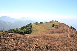
There are two trekking seasons at Paithalmala | Paithalmala is a popular trekking destination. There are two trekking seasons at Paithalmala: [[monsoon]] and summer. Trekking in Paithalmala can be challenging due to frequent rain, [[leech]]es, and occasional [[elephant]] visits. [[File:Paithalmala Hill top.JPG|thumb|right|Paithalmala Hilltop: The observatory tower is seen at the extreme]] | ||
Monsoon is followed by a cool climate in Paithalmala and the | Monsoon is followed by a cool climate in Paithalmala and the grass surrounding the hills grow to their fullest size, making it difficult to walk through. As they grow above seven feet, finding the regular way becomes a difficult task. By December, the forest caretakers set fire to the grass, taking care of the rest of the forest, to ease out the trekking experience. Soon after this, the hill becomes unsuitable to trek because of the black sooth formed but clears away after a couple of weeks. Most people generally trek between January and March. | ||
== | == Tourism == | ||
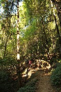
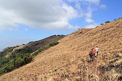
There is an observatory tower made by the department of tourism at the hilltop which can be reached after a 45 min walk from the Paithal valley. Trekking starts through the dense forest followed by the plain grass land on the hill top.[[File:Trekkers through the forest trail.JPG|thumb|right|Forest trail towards the hill]] | There is an observatory tower made by the department of tourism at the hilltop which can be reached after a 45 min walk from the Paithal valley. Trekking starts through the dense forest followed by the plain grass land on the hill top. At the highest point of the observatory, the observer can see more than half the area of Kannur district.[[File:Trekkers through the forest trail.JPG|thumb|right|Forest trail towards the hill]] [[File:Trekkers through Paithal hills.JPG|thumb|Trekkers at paithal hills]] | ||
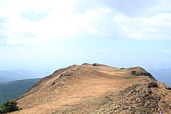
[[File:Scenic view from the hilltop.JPG|thumb|Scenic view from the hilltop]] | [[File:Scenic view from the hilltop.JPG|thumb|Scenic view from the hilltop]] | ||
The | The main part of the trek is considered to be the walk from the [[observatory]] tower to the thick forest where trail from Kappimala ends, where the [[Coorg]] forest and Paithal valley can be seen. Mobile networks other than BSNL are not available in the vicinity. | ||
== | == Problems with Pollution == | ||
Since accessibility to it is limited, Paithalmala is one of the few places in [[Kerala]] where nature is largely unaffected by human invasion. Recently however, visitors have increasingly tended to use it as a drinking spot. The observatory tower is in poor condition as its walls and barricades are broken or destroyed, and the surroundings of the tower are littered with beer bottles and plastic items. The hill top remains largely non-polluted and visitors are advised to preserve it. | |||
==See also== | ==See also== | ||
{{Portal|India}} | |||
* [[Kudianmala]] | * [[Kudianmala]] | ||
* [[Naduvil]] | * [[Naduvil]] | ||
| Line 61: | Line 50: | ||
==External links== | ==External links== | ||
{{commonscat|Paithalmala}} | {{commonscat|Paithalmala}} | ||
*[http://paithalmalatourism.com Paithal Resorts DTDC Guest House] | *[http://paithalmalatourism.com Paithal Resorts DTDC Guest House] {{Webarchive|url=https://web.archive.org/web/20160402100426/http://paithalmalatourism.com/ |date=2 April 2016 }} | ||
*[http://www.paithalmala.info www.paithalmala.info] | *[http://www.paithalmala.info www.paithalmala.info] {{Webarchive|url=https://web.archive.org/web/20211210083838/http://paithalmala.info/ |date=10 December 2021 }} | ||
{{Western Ghats}} | {{Western Ghats}} | ||
{{Tourism in Kerala |state=collapsed}} | {{Tourism in Kerala |state=collapsed}} | ||
Latest revision as of 19:43, 22 July 2025
 | This article contains promotional content. (March 2017) |
| Paithalmala | |
|---|---|
 Paithalmala | |
| Highest point | |
| Elevation | 1,371.6 m (4,500 ft) |
| Coordinates | 12°10′07″N 75°33′42″E / 12.1685°N 75.5618°E |
| Naming | |
| English translation | പൈതൽമല |
| Language of name | Malayalam |
| Geography | |
  Paithalmala Location of Paithalmala in Kerala  Paithalmala Paithalmala (India) | |
| Location | Taliparamba, Kannur, Kerala, India |
| Parent range | Western Ghats |
| Geology | |
| Mountain type | Tourism |
| Climbing | |
| Easiest route | From Potenplave, via Kudiyanmala |
Paithalmala is a hill station in the Kannur district of Kerala in India, located near Pottenplave. At a height of 4500 ft above from sea level, it is the highest geographic peak in Kannur.[1] It is located 40 km from Taliparamba and 65 km from Kannur. Nestled in the Kerala Karnataka border near to Kodagu forests, it lies in the Western Ghats.
Trekking at Paithalmala[edit | edit source]
Paithalmala is a popular trekking destination. There are two trekking seasons at Paithalmala: monsoon and summer. Trekking in Paithalmala can be challenging due to frequent rain, leeches, and occasional elephant visits.

Monsoon is followed by a cool climate in Paithalmala and the grass surrounding the hills grow to their fullest size, making it difficult to walk through. As they grow above seven feet, finding the regular way becomes a difficult task. By December, the forest caretakers set fire to the grass, taking care of the rest of the forest, to ease out the trekking experience. Soon after this, the hill becomes unsuitable to trek because of the black sooth formed but clears away after a couple of weeks. Most people generally trek between January and March.
Tourism[edit | edit source]
There is an observatory tower made by the department of tourism at the hilltop which can be reached after a 45 min walk from the Paithal valley. Trekking starts through the dense forest followed by the plain grass land on the hill top. At the highest point of the observatory, the observer can see more than half the area of Kannur district.


The main part of the trek is considered to be the walk from the observatory tower to the thick forest where trail from Kappimala ends, where the Coorg forest and Paithal valley can be seen. Mobile networks other than BSNL are not available in the vicinity.
Problems with Pollution[edit | edit source]
Since accessibility to it is limited, Paithalmala is one of the few places in Kerala where nature is largely unaffected by human invasion. Recently however, visitors have increasingly tended to use it as a drinking spot. The observatory tower is in poor condition as its walls and barricades are broken or destroyed, and the surroundings of the tower are littered with beer bottles and plastic items. The hill top remains largely non-polluted and visitors are advised to preserve it.
See also[edit | edit source]

References[edit | edit source]
- ↑ "Highest peak of Kannur". 2006. ISBN 9788190250511.
External links[edit | edit source]
- Paithal Resorts DTDC Guest House Archived 2 April 2016 at the Wayback Machine
- www.paithalmala.info Archived 10 December 2021 at the Wayback Machine


