.svg)
Shivanasamudra Falls
| Shivanasamudra Falls | |
|---|---|
| Barachukki and Gaganachukki Falls | |
 Shivanasamudra Kaveri Falls | |
 | |
| Location | mandya, Karnataka, India |
| Coordinates | 12°18′00″N 77°10′37″E / 12.3°N 77.177°ECoordinates: 12°18′00″N 77°10′37″E / 12.3°N 77.177°E |
| Type | Segmented |
| Total height | 90 metres (300 ft) |
| Number of drops | Gaganachukki, Barachukki |
| Watercourse | Kaveri River |
| Average flow rate | 934 cubic metres/s (33,000 cubic ft/s) |
Shivanasamudra Falls is a waterfall in Chamarajanagar districtof the state of Karnataka, India. It is situated along the river Kaveri, which forms here the boundary to the Chamarajanagar district and Mandya district. Barachukki Falls in Kollegal Taluk Chamarajanagar district and Gaganachukki Falls in Malavalli Taluk Mandya district and is the location of one of the first hydro-electric power stations in Asia, which was set up in 1902.The project was designed by Diwan Sheshadri Iyer , Diwan Sir M Vishveshwaraya
Waterfalls[edit]
The Shivanasamudra Falls is on the Kaveri River after the river has found its way through the rocks and ravines of the Deccan Plateau and drops off to form waterfalls.[1] The island town of Shivanasamudra divides the river into twin waterfalls. This creates the fourth largest island in the course of the river.[citation needed] A group of ancient temples is located here and there likely was a village.
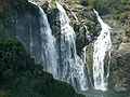
This is a segmented waterfall. Segmented waterfalls occur where the water flow is broken into two or more channels before dropping over a cliff, resulting in multiple sides by side waterfalls. It has an average width of 305 meters (1,001 ft), a height of 98 m (322 ft), and an average volume of 934 cubic metres per second (33,000 cu ft/s). The maximum recorded volume is 18,887 cubic metres per second (667,000 cu ft/s).
It is a perennial waterfall. The time of best flow are the monsoon season of July to October.[2]
A common misconception about these waterfalls is that the left segment is called Gaganachukki and the right segment is called Bharachukki. In reality the Bharachukki falls[3] are a few kilometers to the south-west of the Gaganachukki falls.[4] This is due to the Kaveri river itself splitting a few kilometers to the south into western and eastern branches.[5] The western branch results in the twin waterfalls of Gaganachukki, whereas the eastern branch results in the Bharachukki falls. The Gaganachukki waterfalls are best viewed from the Shivanasamudra watch tower.[6] Most of the pictures showing the twin waterfalls are taken from that location. There is another approach to the Gaganachukki falls from the Darga Hazrath Mardane Gaib (Imam Ali).[7] Despite warnings being posted, people climb down the rocks and attempt to view the waterfalls from behind/top, resulting in many fatal accidents. It is 139 km (86 mi) from the city of Bangalore.
Temples[edit]
Sri Ranganathaswamy Temple located here is built in the Dravidian style of architecture. Sri Ranganathaswamy here is also referred to as "Madhya Ranga", who is highly revered by Sri Vaishnava devotees among others. Among all the three Rangas, the deity here is believed to represent the youth form of God and hence is also fondly referred to as 'Mohana Ranga' and 'Jaganmohana Ranga'. Madhya Ranga is an ancient temple housing a beautiful idol, yet being located remotely sees few visitors. The temple often remains closed to visitors as the local priest is not punctual, and the Karnataka government temple authority has done little to maintain and promote this place.[8] There are three more temples on three other sides of the island.[citation needed]
The ancient Sri Someshwara Temple is another famous temple here at Sivasamudram. Adi guru Sri Shankaracharya is said to have visited this place and established a "Sri Chakra". It is unusually believed that the Someshwara Linga here has existed much before the Ranganantha idol and that the Saptarshis was performing pooja and worshipping this Linga.[citation needed]
The Shakthi Devathe temple of Vanadurga Devi is 1 kilometre (0.62 mi) away from the Someshwara temple.[citation needed]
Template:Mysore Kingdom series
Power-generation[edit]
India's second hydro-electric power station is located at the waterfall and is still functional.[citation needed] This station was commissioned by the Diwan of Mysore, Sir K. Seshadri Iyer. The power generated here was initially used in Kolar Gold Fields. India's first hydro-electric power station is located at Darjeeling Sidrapong Hydroelectric Power Station. They were among the first in Asia.
One can visit the power station by obtaining special permission through Karnataka Power Corporation. Travelling in British built winch lift is an experience.
Transportation[edit]
There are several buses available from Bangalore KR Market and Malavalli to Milega. It is recommended to board off at Satya Gala Hand Post; the distance being 2 kilometres (1.2 mi).
Many three-wheelers are available between the falls and the hand post. Recently many eco-friendly resorts, like Chukkimane and Ecoland Farms , have emerged near to these waterfalls which offer a night stay for the travelers who would wish to spend another day at the falls.
There is a small restaurant run by Karnataka State Tourism Development Corporation at Gaganachukki Falls. Apart from this, tourists have to come to the highway where there are few dhabhas.[what language is this?]
Gallery[edit]

Bharachukki Falls Sivasamudram

Barachukki

Barachukki Falls, c. 1905
Sivasamudram Falls
- SivanaSamudra.JPG
Sivasamudram in full flow

Sivasamudram at Barachukki

The Kaveri Falls, c. 1905

Rainbow over the falls


See also[edit]
Notes[edit]
- "Tourist Places/Attractions in mandya District". All Places India. Retrieved 13 August 2014.
- "Shortage of water hits power generation at Shivanasamudra plant". The Hindu. 12 July 2014. Retrieved 13 August 2014.
- "Shivanasamudra soon to host solar power plant". Deccan Herald. 17 March 2012. Retrieved 13 August 2014.