Malenadu
This article has multiple issues. Please help improve it or discuss these issues on the talk page. (Learn how and when to remove these template messages)
|
Malenadu
Malnad | |
|---|---|
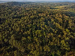
 Forests of Malenadu | |
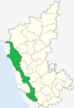
 Malenadu region shown in Green | |
| Country | |
| State | Karnataka |
| Region | Malnad |
| Districts | Uttara Kannada Chikmagalur Shivamogga Hassan Kodagu Belgaum |
| Languages | |
| • Official | Kannada |
| • Regional | Kannada, Kodava, Tulu Konkani |
| Time zone | UTC+5:30 (IST) |
| Website | http://madb.kar.nic.in/ |
Malenadu is a region in the state of Karnataka in India. Malenadu covers the western and eastern slopes of the Western Ghats or Sahyadri mountain range, and is roughly 100 kilometers in width.
Climate and rainfall statistics[edit]
Western ghats act as the rain barrier during south-west monsoon season. This region is one of the wettest regions in the world where the rainfall measurements had overflown over 7000mm whereas Cheerapunji and Mawsynram at average receives about 11,000mm of rainfall per year.
The following were the top 5 places that captured rainfall record statistics [2010-2017][1][2][3][4]
| Rank | Hobli/Village | District | Taluk | Year | Rainfall in mm | Elevation in metres |
|---|---|---|---|---|---|---|
| 1 | Amagaon | Belgaum district | Khanapur | 2010 | 10,068 | 785 |
| 2 | Mundrote | Kodagu district/Coorg District | Madikeri | 2011 | 9,974 | 585 |
| 3 | Hulikal | Shimoga district | Hosanagara | 2013 | 9,383 | 614 |
| 4 | Agumbe | Shimoga district | Thirthahalli | 2013 | 8,770 | 643 |
| 5 | Kokalli/Kakalli | Uttara Kannada | Sirsi | 2014 | 8,746 | 780 |
The table below is comparison of rainfalls for between Agumbe in Thirthahalli taluk in Shimoga district, Hulikal in Hosanagara taluk in Shimoga district, Amagaon in Khanapur Taluk in Belgaum district and Talacauvery in Madikeri taluk in Kodagu district, Kokalli of Sirsi Taluk, Nilkund of Siddapur Taluk, CastleRock of Supa (Joida) Taluk in Uttara Kannada District to show which one can be called the "Cherrapunji of South India".[5]
| Year | Hulikal Rainfall (mm) | Agumbe Rainfall (mm) | Amagaon Rainfall (mm) | Talacauvery Rainfall (mm)[6] | Kokalli Rainfall (mm) | Nilkund Rainfall (mm) | Castle Rock Rainfall (mm) |
|---|---|---|---|---|---|---|---|
| 2017 | 5,700 | 6,311 | 4,733 | 5,859 | 3130 | 4981 | 5560 |
| 2016 | 5,721 | 6,449 | 4,705 | 5,430 | 2682 | 4655 | 4968 |
| 2015 | 6,035 | 5,518 | 4,013 | 5,319 | 2730 | 4367 | 3667 |
| 2014 | 7,907 | 7,917 | 5,580 | 7,844 | 8746 | 6710 | 5956 |
| 2013 | 9,383 | 8,770 | 8,440 | 8,628 | 4464 | 7082 | 3667 |
| 2012 | 8,409 | 6,933 | 5,987 | 5,722 | 5036 | 5398 | 6165 |
| 2011 | 8,523 | 7,921 | 9,368 | 6,855 | 4437 | 6593 | 7083 |
| 2010 | 7,717 | 6,929 | 10,068 | 6,794 | 4002 | - | - |
| 2009 | 8,357 | 7,982 | - | - | - | - | - |
| 2008 | 7,115 | 7,199 | - | - | - | - | - |
| 2007 | 9,038 | 8,255 | - | - | - | - | - |
| 2006 | 8,656 | 8,457 | - | - | -[7][8] | - | - |
See also[edit]
References[edit]
- ↑ "Rainfall Statistics for Kokalli (Ajjimane)" (PDF). DES Karnataka.
- ↑ "Rainfall Statistics for Amagaon" (PDF). DES Karnataka.
- ↑ "Rainfall Statistics for Mundrote" (PDF). DES Karnataka.
- ↑ "Rainfall Statistics for Agumbe and Hulikal" (PDF). DES karnataka.
- ↑ Hulikal in Shimoga district is wettest in State from TheHindu.com accessed 23 March 2013
- ↑ Amagaon has got over 10,000 mm annual rainfall twice in the five years (2006-2010). The exact amount of rainfall is not available. See Amagaon is now Cherrapunji of South from DeccanHerald.com accessed 23 March 2013
- ↑ "Govt of Karnataka Rainfall Statistics (Kokalli)" (PDF). DES.
- ↑ "Rainfall Statistics of Karnataka". DES Karnataka.