



>Yamaguchi先生 m Reverted edits by 150.129.101.119 (talk) to last version by Kambliyil |
StaciWinslow (talk | contribs) m minor edit |
||
| Line 2: | Line 2: | ||
{{Use Indian English|date=October 2018}} | {{Use Indian English|date=October 2018}} | ||
{{Infobox settlement | {{Infobox settlement | ||
| name | | name = Kottakkal | ||
| | | other_name = Land of the Fort | ||
| | | settlement_type = Municipal town | ||
| | | image_skyline = Kottakkal co in 0002.jpg | ||
| | | image_caption = Kottakkal Town rainy day | ||
| | | nickname = Ayurveda City <ref>{{cite web | url=https://www.keralatourism.org/destination/kottakkal-malappuram/32 | title=Kottakkal - the town famous for Arya Vaidya Sala, an Ayurvedic institution, Malappuram }}</ref> | ||
| | | image_alt = | ||
| image_alt | | map_alt = | ||
| | | map_caption = | ||
| pushpin_map | | pushpin_map = India Kerala#India#Asia#Earth | ||
| pushpin_label_position | | pushpin_label_position = right | ||
| pushpin_map_alt | | pushpin_map_alt = | ||
| pushpin_map_caption | | pushpin_map_caption = Kottakkal ([[Kerala]]) | ||
| coordinates | | coordinates = {{coord|10.9990|N|75.9918|E|display=inline,title}}[https://geohack.toolforge.org/geohack.php?pagename=Kottakkal¶ms=10.9990_N_75.9918_E_type:city(44382)_region:IN-KL] | ||
| subdivision_type | | subdivision_type = [[Country]] | ||
| subdivision_name | | subdivision_name = {{flag|India}} | ||
| subdivision_type1 | | subdivision_type1 = [[States and territories of India|State]] | ||
| subdivision_name1 | | subdivision_name1 = [[Kerala]] | ||
| subdivision_type2 | | subdivision_type2 = [[List of districts of India|District]] | ||
| subdivision_name2 | | subdivision_name2 = [[Malappuram district|Malappuram]] | ||
| established_title | | established_title = <!-- Established --> | ||
| established_date | | established_date = | ||
| founder | | founder = | ||
| named_for | | named_for = | ||
| government_type | | government_type = [[Municipal council (India)|Municipal council]] | ||
| governing_body | | governing_body = [[Kottakkal Municipality]] | ||
| leader_title | | leader_title = Chairperson | ||
| leader_name | | leader_name = K.K Nasar ([[IUML]]) | ||
| unit_pref | | leader_title1 = Vice Chairperson | ||
| area_footnotes | | leader_name1 = Paroli Ramla Teacher ([[IUML]]) | ||
| area_rank | | unit_pref = Metric | ||
| area_total_km2 | | area_footnotes = | ||
| elevation_footnotes | | area_rank = | ||
| elevation_m | | area_total_km2 = 20.45 | ||
| population_total | | elevation_footnotes = | ||
| population_as_of | | elevation_m = 84.34 | ||
| population_rank | | population_total = 44,382 | ||
| population_density_km2 | | population_as_of = 2011 | ||
| population_demonym | | population_rank = | ||
| population_footnotes | | population_density_km2 = auto | ||
| demographics_type1 | | population_demonym = | ||
| demographics1_title1 | | population_footnotes = <ref name="Population in Malappuram municipalities">{{cite book |last1=Kerala |first1=Directorate of Census Operations |title=District Census Handbook, Malappuram |publisher=Directorate of Census Operations, Kerala |location=Thiruvananthapuram |page=172 |url=https://censusindia.gov.in/2011census/dchb/3205_PART_B_MALAPPURAM.pdf |access-date=14 July 2020}}</ref> | ||
| demographics1_info1 | | demographics_type1 = [[Language]]s | ||
| timezone1 | | demographics1_title1 = Official | ||
| utc_offset1 | | demographics1_info1 = [[Malayalam language|Malayalam]], [[English language|English]] | ||
| postal_code_type | | timezone1 = [[Indian Standard Time|IST]] | ||
| postal_code | | utc_offset1 = +5:30 | ||
| area_code_type | | postal_code_type = [[Postal Index Number|PIN]] | ||
| area_code | | postal_code = 676503 | ||
| registration_plate | | area_code_type = [[Telephone]] code | ||
| website | | area_code = +91483xxxxxxx | ||
| footnotes | | registration_plate = KL-10, KL-55, KL-65 | ||
| website = {{URL|http://www.kottakkal.lsgkerala.gov.in/en}} | |||
| footnotes = | |||
}} | }} | ||
'''Kottakkal''' (literally-''Land of the Fort'') is a [[municipality|municipal town]] in [[ | '''Kottakkal''' (literally-''Land of the Fort'') is a major [[municipality|municipal town]] in [[Malappuram district]] in [[Kerala]], having 32 [[Ward (country subdivision)|wards]]. It is one of the four municipalities in [[Tirur Taluk]], besides [[Tirur]], [[Valanchery]], and [[Tanur, Malappuram|Tanur]]. It is a part of the [[Malappuram metropolitan area]] and a growing city in Kerala.<ref name="Malappuram metropolitan area">{{cite web |url=https://kerala.gov.in/documents/10180/622777/urban |website=kerala.gov.in |title=Constituents of Malappuram metropolitan area |access-date=1 April 2021 |archive-date=30 December 2020 |archive-url=https://web.archive.org/web/20201230044541/https://kerala.gov.in/documents/10180/622777/urban |url-status=dead }}</ref><ref>{{cite news |url= https://www.thehindubusinessline.com/news/national/%E2%80%98Kottakkal%E2%80%99-aims-for-expansion-in-North-India/article20808444.ece/ |title= 'Kottakkal' aims for expansion in North India |last= K. P. M. Basheer |publisher= The Hindu Business Line |date= 30 June 2014}}</ref> The town is best known for the [[Arya Vaidya Sala]], one of the top [[Ayurveda|Ayurvedic]] health centres in the world.<ref name="Arya Vaidya Sala Kottakkal - Part 1 ">{{cite AV media | url=https://www.youtube.com/watch?v=nj6YqhsUo0c |archive-url=https://ghostarchive.org/varchive/youtube/20211221/nj6YqhsUo0c |archive-date=2021-12-21 |url-status=live| title=Arya Vaidya Sala Kottakkal – Part 1 | publisher=BBC World – India Business Report | date=30 May 2013 | medium=Documentary}}{{cbignore}}</ref> Kottakkal is also a major growing commercial, educational, and healthcare hub in [[South Malabar]].<ref name="Population in Malappuram municipalities"/> The town lies on the [[Mumbai]]–[[Kanyakumari]] [[National Highway 66 (India)|National Highway 66]]. | ||
Kottakkal is located {{Convert|12|km||abbr=on}} southwest of [[Malappuram]], the district headquarters, and {{Convert|14.5|km||abbr=on}} from Tirur | Kottakkal is located {{Convert|12|km||abbr=on}} southwest of [[Malappuram]], the district headquarters, and {{Convert|14.5|km||abbr=on}} from [[Tirur railway station]].The [[National Highway 66]] separates the municipality from [[Edarikode|Edarikode grama panchayat]] on some parts to the west.<ref>{{cite web |url=http://www.exoticindiaart.com/book/details/IDC162/ |title=A Life of Healing (A Biography of Vaidyaratnam P.S. Varier) |website=www.exoticindiaart.com |access-date=11 January 2022 |archive-url=https://web.archive.org/web/20110129234527/http://www.exoticindiaart.com/book/details/IDC162/ |archive-date=29 January 2011 |url-status=dead}}</ref> However, the fast-developing Kottakkal urban area is now spread up to different parts of neighboring panchayats such as [[Edarikode|Edarikkode.]] | ||
Kottakkal | Kottakkal town became famous after the establishment of [[Arya Vaidya Sala]] in 1902. Adding to the cultural heritage, [[Kottakkal pooram|Kottakkal Pooram]], The popular temple festival is celebrated over seven days during March–April.<ref>{{cite web|url=http://www.aryavaidyasala.com/ |title=Kottakkal Arya Vaidya Sala |access-date=2012-12-18}}</ref> | ||
== History == | == History == | ||
An [[Old Malayalam]] inscription which dates back to 932 CE found from Indianoor in Kottakkal mention the name of [[Goda Ravi]] of [[Chera dynasty]].<ref name=":0">Narayanan, M. G. S. ''[https://books.google. | An [[Old Malayalam]] inscription which dates back to 932 CE found from Indianoor in Kottakkal mention the name of [[Goda Ravi]] of [[Chera dynasty]].<ref name=":0">Narayanan, M. G. S. ''[https://books.google.com/books?id=0YDCngEACAAJ&q=Perumals+of+Kerala Perumals of Kerala: Brahmin Oligarchy and Ritual Monarchy Perumāḷs of Kerala].'' Thrissur (Kerala): CosmoBooks, 2013. 438-42.</ref> | ||
Kottakkal, formerly known as ''Sweta Durgam'' (the White Fort) in [[Sanskrit]], ''Venkalikotta'' and ''Venkita Kotta'' in [[Malayalam]], was a [[military base]] of the [[Valluvanad (southern Malabar)|Kingdom of Valluvanadu]] earlier.<ref name="Med">{{Cite news|title=Medieval swords found at Kottakkal|url=https://www.thehindu.com/news/national/kerala/medieval-swords-found-at-kottakkal/article4785632.ece|last=R. Madhvan Nair|date=6 June 2013|access-date=25 July 2020|work=The Hindu}}</ref> | Kottakkal, formerly known as ''Sweta Durgam'' (the White Fort) in [[Sanskrit]], ''Venkalikotta'' and ''Venkita Kotta'' in [[Malayalam]], was a [[military base]] of the [[Valluvanad (southern Malabar)|Kingdom of Valluvanadu]] earlier.<ref name="Med">{{Cite news|title=Medieval swords found at Kottakkal|url=https://www.thehindu.com/news/national/kerala/medieval-swords-found-at-kottakkal/article4785632.ece|last=R. Madhvan Nair|date=6 June 2013|access-date=25 July 2020|work=The Hindu}}</ref> | ||
Two swords, medieval European in style and finish, were discovered in a well from Kottakkal, in the year 2013.<ref name="Med"/> The [[Zamorin]] of [[Calicut]] invaded the [[Kingdom of Valluvanad]] in 14th century CE and seized the fort at Kottakkal.<ref name="Med"/> The Zamorin captuted the captaincy of [[Mamankam festival]] in the same period. Karuvayoor Moosad, who was the minister of ''Valluvakonathiri'', based at Kottakkal and also the chief marshal and preacher of the ''Moopil Nair''s, changed his seat to [[Puzhakkattiri]] when Kottakkal came under [[Zamorin]].<ref name="Med"/> It may be the forts and castles constructed by the Karuvayoor Moosad that were the origin of the name "Kottakkal".<ref name="ps">{{Cite web|url=https://malappuram.keralapolice.gov.in/wings/police-stations/kottakkal-ps|title=Kottakkal PS|website=Kerala police}}</ref> | Two swords, medieval European in style and finish, were discovered in a well from Kottakkal, in the year 2013.<ref name="Med"/> The [[Zamorin]] of [[Calicut]] invaded the [[Kingdom of Valluvanad]] in 14th century CE and seized the fort at Kottakkal.<ref name="Med"/> The Zamorin captuted the captaincy of [[Mamankam festival]] in the same period. Karuvayoor Moosad, who was the minister of ''Valluvakonathiri'', based at Kottakkal and also the chief marshal and preacher of the ''Moopil Nair''s, changed his seat to [[Puzhakkattiri]] when Kottakkal came under [[Zamorin]].<ref name="Med"/> It may be the forts and castles constructed by the Karuvayoor Moosad that were the origin of the name "Kottakkal".<ref name="ps">{{Cite web|url=https://malappuram.keralapolice.gov.in/wings/police-stations/kottakkal-ps|title=Kottakkal PS|website=Kerala police}}</ref> | ||
The ''Kizhakke Kovilakam'', where the eastern branch of the royal family of [[Zamorin]] resided, is located at Kottakkal.Gradually, Kottakkal was annexed to the kingdom of the [[Zamorin of Calicut]].<ref name="Iyer">K. V. Krishna Iyer ''Zamorins of Calicut: From the Earliest Times to AD 1806''. Calicut: Norman Printing Bureau, 1938</ref> The ''Kizhakke Kovilakam'', which was the eastern palace of the royal family of the [[Zamorin of Calicut]], is present at Kottakkal.<ref name="1961_kkd">{{Cite book|title=District Census Handbook (2) - Kozhikode (1961)|last=Devassy|first=M. K.|publisher=Government of Kerala|year=1965|location=Ernakulam|url=http://lsi.gov.in:8081/jspui/bitstream/123456789/5665/1/22059_1961_KOZ.pdf}}</ref> | The ''Kizhakke Kovilakam'', where the eastern branch of the royal family of [[Zamorin]] resided, is located at Kottakkal.Gradually, Kottakkal was annexed to the kingdom of the [[Zamorin of Calicut]].<ref name="Iyer">K. V. Krishna Iyer ''Zamorins of Calicut: From the Earliest Times to AD 1806''. Calicut: Norman Printing Bureau, 1938</ref> The ''Kizhakke Kovilakam'', which was the eastern palace of the royal family of the [[Zamorin of Calicut]], is present at Kottakkal.<ref name="1961_kkd">{{Cite book|title=District Census Handbook (2) - Kozhikode (1961)|last=Devassy|first=M. K.|publisher=Government of Kerala|year=1965|location=Ernakulam|url=http://lsi.gov.in:8081/jspui/bitstream/123456789/5665/1/22059_1961_KOZ.pdf}}</ref> | ||
[[Arya Vaidya Sala]] was established in 1902.<ref name="Arya Vaidya Sala Kottakkal - Part 1 "/> The suburbs of Kottakkal were known as ''Changuvettikkadu'' and ''Eyyakkadu'' (now Changuvetti is developing as a [[Twin cities (geographical proximity)|twin town]] to Kottakkal). | [[Arya Vaidya Sala]] was established in 1902.<ref name="Arya Vaidya Sala Kottakkal - Part 1 "/> The suburbs of Kottakkal were known as ''Changuvettikkadu'' and ''Eyyakkadu'' (now Changuvetti is developing as a [[Twin cities (geographical proximity)|twin town]] to Kottakkal). | ||
== Municipal elections == | == Municipal elections == | ||
[[File:Kottakkal Town.JPG|thumb|Kottakkal town]] | [[File:Kottakkal Town.JPG|thumb|Kottakkal town]] | ||
The [[United Democratic Front ( | The [[United Democratic Front (Kerala)|United Democratic Front]] won the first elections (held in October 2010) to the Kottakkal municipality.<ref>{{Cite web |url=http://trend.kerala.gov.in/trendsite/main/Election2010.html |title=Local Body Elections, Kerala 2010 - National Informatics Centre |access-date=28 October 2010 |archive-url=https://web.archive.org/web/20101028023610/http://trend.kerala.gov.in/trendsite/main/Election2010.html |archive-date=28 October 2010 |url-status=dead }}</ref> K. K. Nazar and Paroli Moosakutty Haji of [[Indian Union Muslim League]] were elected as the Chairperson and Vice-Chairman respectively of the municipality.<ref>[https://web.archive.org/web/20101113183628/http://www.hindu.com/2010/11/09/stories/2010110952300300.htm The Hindu : Kerala / Malappuram News : Municipalities get new chiefs<!-- Bot generated title -->]</ref> Other major Political representatives in the Municipality include TP Subair and Nani of [[Left Democratic Front (Kerala)|Left Democratic Front]]. | ||
===[[2020 Kerala local body elections|Kottakkal Municipality]] Election 2020 | |||
===[[2020 Kerala local body elections|Kottakkal Municipality]] Election 2020=== | |||
{|class="sortable wikitable" | {|class="sortable wikitable" | ||
|- | |- | ||
!S.No. !! Party | !S.No.<ref>{{Cite web|url=http://trend.kerala.gov.in/views/index.php|title=Kottakkal Municipality election 2020|access-date=2020-12-11|website=lbtrend|archive-date=9 March 2021|archive-url=https://web.archive.org/web/20210309203519/http://trend.kerala.gov.in/views/index.php|url-status=dead}}</ref> !! Party name !! Party symbol !! Number of Councillors | ||
|- | |- | ||
| 01 || [[United Democratic Front (Kerala)|UDF]] ||[[File:UDF | | 01 || [[United Democratic Front (Kerala)|UDF]] ||[[File:UDF logo.png|50px]] || 20 | ||
|- | |- | ||
| 02 || Independents || [[File:No flag.svg| | | 02 || Independents || [[File:No flag.svg|50px]] || 07 | ||
|- | |- | ||
| 03 || [[Left Democratic Front (Kerala)|LDF]] ||[[File: | | 03 || [[Left Democratic Front (Kerala)|LDF]] ||[[File:Left Democratic Front (Kerala) Logo.svg|50px]] || 03 | ||
|- | |- | ||
| 04 || [[Bharatiya Janata Party|BJP]] ||[[File:BJP election symbol.svg -783x768.png|50px]] || 02 | | 04 || [[Bharatiya Janata Party|BJP]] ||[[File:BJP election symbol.svg -783x768.png|50px]] || 02 | ||
| Line 95: | Line 94: | ||
|} | |} | ||
== Notable | == Notable people == | ||
<!---♦♦♦ Only add a person to this list if they already have their OWN article on the English Bharatpedia ♦♦♦---> | |||
<!---♦♦♦ Please keep the list in alphabetical order by LAST NAME ♦♦♦---> | |||
* [[U. A. Beeran]] | * [[U. A. Beeran]] | ||
* [[Jayasree Kalathil]], | * [[Jayasree Kalathil]], researcher | ||
*[[ | * [[Kottakkal Madhu]], [[Kathakali]] singer | ||
* [[ | * [[Athippatta Moideen Kutty Musliyar]], Islamic scholar | ||
* [[Sangita Madhavan Nair]], actress | |||
* [[V. C. Balakrishna Panicker]] | * [[V. C. Balakrishna Panicker]] | ||
* [[ | * [[K. C. Manavedan Raja]], founder of Raja's High School, [[Zamorin|Zamorin of Calicut]] during 1932-1937 | ||
* [[M. P. Abdussamad Samadani]] | * [[M. P. Abdussamad Samadani]], politician, MLA, former [[Member of Parliament]] | ||
* [[Sachin Warrier]] | * [[Kottakkal Sivaraman]], [[Kathakali]] artist | ||
* [[Najma Thabsheera]] Lawyer and politician | |||
* [[Manorama Thampuratti]], [[Sanskrit]] poet | |||
* [[Vaidyaratnam P. S. Varier]], founder of Kottakkal Arya Vaidya Sala | |||
* [[M. K. Vellodi]], Indian civil servant, diplomat, former Cabinet Secretary | |||
* [[P. K. Warrier]] | |||
* [[Sachin Warrier]], playback singer and composer | |||
[[File:Puthur .jpg|thumb|Moody Evening]] | [[File:Puthur .jpg|thumb|Moody Evening]] | ||
==Basic information of Kottakkal Municipality== | ==Basic information of Kottakkal Municipality== | ||
[[File:Kottakkal Arya Vaidya Sala OP Block.jpg|alt=Kottakkal|thumb|Kottakkal Arya Vaidya Sala,Out Patients Block]] | [[File:Kottakkal Arya Vaidya Sala OP Block.jpg|alt=Kottakkal|thumb|Kottakkal Arya Vaidya Sala, Out Patients Block]] | ||
[[File:Government Rajah's Higher Secondary School, Kottakkal.jpg|thumb|Government Rajah's Higher Secondary School, Kottakkal]] | [[File:Government Rajah's Higher Secondary School, Kottakkal.jpg|thumb|Government Rajah's Higher Secondary School, Kottakkal]] | ||
[[File:Kottakkal Bypass.jpg|alt=Kottakkal|thumb|218x218px|Puthur, Kottakkal]] | [[File:Kottakkal Bypass.jpg|alt=Kottakkal|thumb|218x218px|Puthur, Kottakkal]] | ||
| Line 125: | Line 126: | ||
|- | |- | ||
| Taluk || [[Tirur]] | | Taluk || [[Tirur]] | ||
|- | |- | ||
| Assembly Constituency || Kottakkal | | Assembly Constituency || Kottakkal | ||
| Line 136: | Line 135: | ||
| Neighbouring Panchayaths || Edarikode, Parappur, Othukkungal, Ponmala and Marakkara | | Neighbouring Panchayaths || Edarikode, Parappur, Othukkungal, Ponmala and Marakkara | ||
|- | |- | ||
| Post Offices || Kottakkal, Puthoor, Indianoor, Pathayakkallu, Kuttippuram, Pandamangalam, | | Post Offices || Kottakkal, Puthoor, Indianoor, Pathayakkallu, Kuttippuram, Pandamangalam, Cherushola , Puthupparamba | ||
|- | |- | ||
|Pincodes | |Pincodes | ||
|676501, 676503, | |676501, 676503, 676510 | ||
|} | |} | ||
<mapframe text="Kottakkal Municipality" width=300 height=300 align=center >{ "type": "ExternalData", "service": "geoshape", "ids": "Q13111679"}</mapframe> | <mapframe text="Kottakkal Municipality" width=300 height=300 align=center >{ "type": "ExternalData", "service": "geoshape", "ids": "Q13111679"}</mapframe> | ||
===Wards=== | ===Wards=== | ||
Kottakkal Municipality is composed of the following 32 wards:<ref>{{cite web | Kottakkal Municipality is composed of the following 32 wards:<ref>{{cite web | ||
| Line 149: | Line 149: | ||
}}</ref> | }}</ref> | ||
{|class="sortable | {| class="wikitable sortable" style="font-size: 95%;" | ||
!width="20px" |Ward no. | !width="20px" |Ward no. | ||
!width="75px" |Name | !width="75px" |Name | ||
| Line 237: | Line 237: | ||
== Transportation == | == Transportation == | ||
* '''Bus services:''' Kottakkal Bus station at the heart of the town, links to all rural bus services around Kottakkal locality and Long route services connecting nearby towns like [[Manjeri]], [[Malappuram]], [[Perinthalmanna]] etc. [[Kerala State Road Transport Corporation|KSRTC]] service also available. | * '''Bus services:''' Kottakkal Bus station at the heart of the town, links to all rural bus services around Kottakkal locality and Long route services connecting nearby towns like [[Tirur]], [[Manjeri]], [[Malappuram]], [[Perinthalmanna]], [[Valanchery]] etc. [[Kerala State Road Transport Corporation|KSRTC]] service also available. | ||
* '''Railway Station:''' [[Tirur railway station]] is one of the major railway stations in the Malabar region. Almost every train stops here, connecting the Malappuram district to the rest of the country. It is located 14 km away from the Kottakkal town. Passengers from Kottakkal can also access Angadippuram railway station which is about 26 km from kottakkal town. | |||
* '''Railway Station:''' [[Tirur | |||
* '''Nearest Airport:''' [[Calicut International Airport]] is approximately 25 kilometres away. | * '''Nearest Airport:''' [[Calicut International Airport]] is approximately 25 kilometres away. | ||
| Line 245: | Line 244: | ||
* [[Vengara, Malappuram district|Vengara]], [[Oorakam]], Cherukulamba, Puthuparamba and [[Edarikode]] | * [[Vengara, Malappuram district|Vengara]], [[Oorakam]], Cherukulamba, Puthuparamba and [[Edarikode]] | ||
* [[Indianoor]], [[Kavathikalam]], [[Marakkara]], [[Kalpakanchery]], Maravattam, [[Kadampuzha]], Puthur, [[Padapparamba]], Chattiparamba | * [[Indianoor]], [[Kavathikalam]], [[Puthanathani]] [[Marakkara]], [[Kalpakanchery]], [[Maravattam]], [[Kadampuzha]], Puthur, [[Padapparamba]], Chattiparamba | ||
* Pang, [[Parappur]], Pottippara, Venniyoor and [[Vettichira]] | * Pang, [[Parappur]], Pottippara, Venniyoor and [[Vettichira]] | ||
==See also== | ==See also== | ||
* [[Kottakkal | * [[Kottakkal Assembly constituency]] | ||
* [[ | * [[Malappuram district]] | ||
* [[Malappuram | * [[Malappuram Lok Sabha constituency]] | ||
* [[Kottakkal Municipality]] | |||
== References == | == References == | ||
| Line 257: | Line 257: | ||
== External links == | == External links == | ||
* [https://geohack.toolforge.org/geohack.php?pagename=Kottakkal¶ms=10.9990_N_75.9918_E_type:city(44382)_region:IN-KL GeoHack - Kottakkal] | |||
* [http://www.wikimapia.org/#lat=10.9995434&lon=76.0019588&z=17&l=0&m=b Kottakkal in Wikimapia] | * [http://www.wikimapia.org/#lat=10.9995434&lon=76.0019588&z=17&l=0&m=b Kottakkal in Wikimapia] | ||
* [http://www.kottakkal.lsgkerala.gov.in/ Kottakkal Municipality] | * [http://www.kottakkal.lsgkerala.gov.in/ Kottakkal Municipality] {{Webarchive|url=https://archive.today/20121219094213/http://www.kottakkal.lsgkerala.gov.in/ |date=19 December 2012 }} | ||
* Documentary on Arya Vaidya Sala in Malayalam - https://www.youtube.com/watch?v=IuPbz-etmMI | * Documentary on Arya Vaidya Sala in Malayalam - https://www.youtube.com/watch?v=IuPbz-etmMI | ||
Latest revision as of 01:45, 28 January 2026
Kottakkal
Land of the Fort | |
|---|---|
Municipal town | |
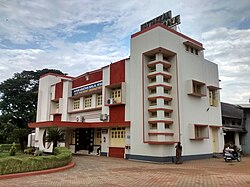
 Kottakkal Town rainy day | |
| Nickname: Ayurveda City [1] | |
  Kottakkal Kottakkal (Kerala)  Kottakkal Kottakkal (India)  Kottakkal Kottakkal (Asia) .svg) Kottakkal Kottakkal (Earth) | |
| Coordinates: 10°59′56″N 75°59′30″E / 10.9990°N 75.9918°E[1] | |
| Country |  India India |
| State | Kerala |
| District | Malappuram |
| Government | |
| • Type | Municipal council |
| • Body | Kottakkal Municipality |
| • Chairperson | K.K Nasar (IUML) |
| • Vice Chairperson | Paroli Ramla Teacher (IUML) |
| Area | |
| • Total | 20.45 km2 (7.90 sq mi) |
| Elevation | 84.34 m (276.71 ft) |
| Population (2011)[2] | |
| • Total | 44,382 |
| • Density | 2,200/km2 (5,600/sq mi) |
| Languages | |
| • Official | Malayalam, English |
| Time zone | UTC+5:30 (IST) |
| PIN | 676503 |
| Telephone code | +91483xxxxxxx |
| Vehicle registration | KL-10, KL-55, KL-65 |
| Website | www |
Kottakkal (literally-Land of the Fort) is a major municipal town in Malappuram district in Kerala, having 32 wards. It is one of the four municipalities in Tirur Taluk, besides Tirur, Valanchery, and Tanur. It is a part of the Malappuram metropolitan area and a growing city in Kerala.[3][4] The town is best known for the Arya Vaidya Sala, one of the top Ayurvedic health centres in the world.[5] Kottakkal is also a major growing commercial, educational, and healthcare hub in South Malabar.[2] The town lies on the Mumbai–Kanyakumari National Highway 66.
Kottakkal is located 12 km (7.5 mi) southwest of Malappuram, the district headquarters, and 14.5 km (9.0 mi) from Tirur railway station.The National Highway 66 separates the municipality from Edarikode grama panchayat on some parts to the west.[6] However, the fast-developing Kottakkal urban area is now spread up to different parts of neighboring panchayats such as Edarikkode.
Kottakkal town became famous after the establishment of Arya Vaidya Sala in 1902. Adding to the cultural heritage, Kottakkal Pooram, The popular temple festival is celebrated over seven days during March–April.[7]
History[edit | edit source]
An Old Malayalam inscription which dates back to 932 CE found from Indianoor in Kottakkal mention the name of Goda Ravi of Chera dynasty.[8]
Kottakkal, formerly known as Sweta Durgam (the White Fort) in Sanskrit, Venkalikotta and Venkita Kotta in Malayalam, was a military base of the Kingdom of Valluvanadu earlier.[9]
Two swords, medieval European in style and finish, were discovered in a well from Kottakkal, in the year 2013.[9] The Zamorin of Calicut invaded the Kingdom of Valluvanad in 14th century CE and seized the fort at Kottakkal.[9] The Zamorin captuted the captaincy of Mamankam festival in the same period. Karuvayoor Moosad, who was the minister of Valluvakonathiri, based at Kottakkal and also the chief marshal and preacher of the Moopil Nairs, changed his seat to Puzhakkattiri when Kottakkal came under Zamorin.[9] It may be the forts and castles constructed by the Karuvayoor Moosad that were the origin of the name "Kottakkal".[10]
The Kizhakke Kovilakam, where the eastern branch of the royal family of Zamorin resided, is located at Kottakkal.Gradually, Kottakkal was annexed to the kingdom of the Zamorin of Calicut.[11] The Kizhakke Kovilakam, which was the eastern palace of the royal family of the Zamorin of Calicut, is present at Kottakkal.[12]
Arya Vaidya Sala was established in 1902.[5] The suburbs of Kottakkal were known as Changuvettikkadu and Eyyakkadu (now Changuvetti is developing as a twin town to Kottakkal).
Municipal elections[edit | edit source]

The United Democratic Front won the first elections (held in October 2010) to the Kottakkal municipality.[13] K. K. Nazar and Paroli Moosakutty Haji of Indian Union Muslim League were elected as the Chairperson and Vice-Chairman respectively of the municipality.[14] Other major Political representatives in the Municipality include TP Subair and Nani of Left Democratic Front.
Kottakkal Municipality Election 2020[edit | edit source]
| S.No.[15] | Party name | Party symbol | Number of Councillors |
|---|---|---|---|
| 01 | UDF |  |
20 |
| 02 | Independents |  |
07 |
| 03 | LDF | _Logo.svg) |
03 |
| 04 | BJP | File:BJP election symbol.svg -783x768.png | 02 |
Notable people[edit | edit source]
- U. A. Beeran
- Jayasree Kalathil, researcher
- Kottakkal Madhu, Kathakali singer
- Athippatta Moideen Kutty Musliyar, Islamic scholar
- Sangita Madhavan Nair, actress
- V. C. Balakrishna Panicker
- K. C. Manavedan Raja, founder of Raja's High School, Zamorin of Calicut during 1932-1937
- M. P. Abdussamad Samadani, politician, MLA, former Member of Parliament
- Kottakkal Sivaraman, Kathakali artist
- Najma Thabsheera Lawyer and politician
- Manorama Thampuratti, Sanskrit poet
- Vaidyaratnam P. S. Varier, founder of Kottakkal Arya Vaidya Sala
- M. K. Vellodi, Indian civil servant, diplomat, former Cabinet Secretary
- P. K. Warrier
- Sachin Warrier, playback singer and composer

Basic information of Kottakkal Municipality[edit | edit source]


| Area | 20.43 km2 (7.89 sq mi) |
| Wards | 32 |
| Taluk | Tirur |
| Assembly Constituency | Kottakkal |
| Loksabha Constituency | Ponnani |
| Vehicle Registration No. | KL-55, KL-10 & KL-65 |
| Neighbouring Panchayaths | Edarikode, Parappur, Othukkungal, Ponmala and Marakkara |
| Post Offices | Kottakkal, Puthoor, Indianoor, Pathayakkallu, Kuttippuram, Pandamangalam, Cherushola , Puthupparamba |
| Pincodes | 676501, 676503, 676510 |

Wards[edit | edit source]
Kottakkal Municipality is composed of the following 32 wards:[16]
| Ward no. | Name | Ward no. | Name |
|---|---|---|---|
| 1 | Changuvetty Junction | 2 | Choonda |
| 3 | Kottakkal Town | 4 | Kottakkal Thazhe Angadi |
| 5 | Palappura | 6 | Mythrinagar |
| 7 | Nayadippara | 8 | Cheenambuthur |
| 9 | Kavathikalam West | 10 | Kavathikalam East |
| 11 | Valiyaparamba | 12 | West Villur |
| 13 | Pappayi | 14 | East Villur |
| 15 | Kooriyad | 16 | Panikkarkundu |
| 17 | Indianoor West | 18 | Indianoor East |
| 19 | Muliyankootta | 20 | Maravettum |
| 21 | Kottoor | 22 | Madrasapadi |
| 23 | Amapara | 24 | Kuttippuram |
| 25 | Aalinchuvadu | 26 | Poozhikkunnu |
| 27 | Palathara | 28 | Kottakkulam |
| 29 | Pulikkode | 30 | Thokkambara |
| 31 | Changuvettykundu | 32 | Khurbani |
Transportation[edit | edit source]
- Bus services: Kottakkal Bus station at the heart of the town, links to all rural bus services around Kottakkal locality and Long route services connecting nearby towns like Tirur, Manjeri, Malappuram, Perinthalmanna, Valanchery etc. KSRTC service also available.
- Railway Station: Tirur railway station is one of the major railway stations in the Malabar region. Almost every train stops here, connecting the Malappuram district to the rest of the country. It is located 14 km away from the Kottakkal town. Passengers from Kottakkal can also access Angadippuram railway station which is about 26 km from kottakkal town.
- Nearest Airport: Calicut International Airport is approximately 25 kilometres away.
Nearby places[edit | edit source]
- Vengara, Oorakam, Cherukulamba, Puthuparamba and Edarikode
- Indianoor, Kavathikalam, Puthanathani Marakkara, Kalpakanchery, Maravattam, Kadampuzha, Puthur, Padapparamba, Chattiparamba
- Pang, Parappur, Pottippara, Venniyoor and Vettichira
See also[edit | edit source]
- Kottakkal Assembly constituency
- Malappuram district
- Malappuram Lok Sabha constituency
- Kottakkal Municipality
References[edit | edit source]
- ↑ "Kottakkal - the town famous for Arya Vaidya Sala, an Ayurvedic institution, Malappuram".
- ↑ 2.0 2.1 Kerala, Directorate of Census Operations. District Census Handbook, Malappuram (PDF). Thiruvananthapuram: Directorate of Census Operations, Kerala. p. 172. Retrieved 14 July 2020.
- ↑ "Constituents of Malappuram metropolitan area". kerala.gov.in. Archived from the original on 30 December 2020. Retrieved 1 April 2021.
- ↑ K. P. M. Basheer (30 June 2014). "'Kottakkal' aims for expansion in North India". The Hindu Business Line.
- ↑ 5.0 5.1 Arya Vaidya Sala Kottakkal – Part 1 (Documentary). BBC World – India Business Report. 30 May 2013. Archived from the original on 21 December 2021.
- ↑ "A Life of Healing (A Biography of Vaidyaratnam P.S. Varier)". www.exoticindiaart.com. Archived from the original on 29 January 2011. Retrieved 11 January 2022.
- ↑ "Kottakkal Arya Vaidya Sala". Retrieved 18 December 2012.
- ↑ Narayanan, M. G. S. Perumals of Kerala: Brahmin Oligarchy and Ritual Monarchy Perumāḷs of Kerala. Thrissur (Kerala): CosmoBooks, 2013. 438-42.
- ↑ 9.0 9.1 9.2 9.3 R. Madhvan Nair (6 June 2013). "Medieval swords found at Kottakkal". The Hindu. Retrieved 25 July 2020.
- ↑ "Kottakkal PS". Kerala police.
- ↑ K. V. Krishna Iyer Zamorins of Calicut: From the Earliest Times to AD 1806. Calicut: Norman Printing Bureau, 1938
- ↑ Devassy, M. K. (1965). District Census Handbook (2) - Kozhikode (1961) (PDF). Ernakulam: Government of Kerala.
- ↑ "Local Body Elections, Kerala 2010 - National Informatics Centre". Archived from the original on 28 October 2010. Retrieved 28 October 2010.
- ↑ The Hindu : Kerala / Malappuram News : Municipalities get new chiefs
- ↑ "Kottakkal Municipality election 2020". lbtrend. Archived from the original on 9 March 2021. Retrieved 11 December 2020.
- ↑ "Wards of Kottakkal". sec.kerala.gov.in.
External links[edit | edit source]
- GeoHack - Kottakkal
- Kottakkal in Wikimapia
- Kottakkal Municipality Archived 19 December 2012 at Archive.today
- Documentary on Arya Vaidya Sala in Malayalam - https://www.youtube.com/watch?v=IuPbz-etmMI


.png)