
->PJsg1011 →top: sd |
No edit summary |
||
| (One intermediate revision by one other user not shown) | |||
| Line 1: | Line 1: | ||
{{short description|River in Maharashtra, India}} | |||
{{See also|Ulhas (disambiguation)}} | |||
{{Use dmy dates|date=July 2017}} | {{Use dmy dates|date=July 2017}} | ||
{{Use Indian English|date=July 2017}} | {{Use Indian English|date=July 2017}} | ||
{{Infobox river | {{Infobox river | ||
| name | | name = Ulhas River | ||
| | | native_name = | ||
| | | native_name_lang = | ||
| name_other | | name_other = | ||
| name_etymology | | name_etymology = <!---------------------- IMAGE & MAP --> | ||
<!---------------------- IMAGE & MAP --> | | image = Ulhas-River.jpg | ||
| image | | image_size = | ||
| image_size | | image_caption = | ||
| image_caption | | map = Geographybombay.png | ||
| map | | map_size = | ||
| map_size | | map_caption = | ||
| map_caption | | pushpin_map = | ||
| pushpin_map | | pushpin_map_size = | ||
| pushpin_map_size | | pushpin_map_caption = <!---------------------- LOCATION --> | ||
| pushpin_map_caption= | | subdivision_type1 = Country | ||
<!---------------------- LOCATION --> | | subdivision_name1 = [[India]] | ||
| subdivision_type1 | | subdivision_type2 = State | ||
| subdivision_name1 | | subdivision_name2 = [[Maharashtra]] | ||
| subdivision_type2 | | subdivision_type3 = | ||
| subdivision_name2 | | subdivision_name3 = | ||
| subdivision_type3 | | subdivision_type4 = | ||
| subdivision_name3 | | subdivision_name4 = | ||
| subdivision_type4 | | subdivision_type5 = Cities | ||
| subdivision_name4 | | subdivision_name5 = [[Mumbai]], [[Thane]] | ||
| subdivision_type5 | <!---------------------- PHYSICAL CHARACTERISTICS -->| length = {{convert|122|km|mi|abbr=on}} | ||
| subdivision_name5 | | width_min = | ||
<!---------------------- PHYSICAL CHARACTERISTICS --> | | width_avg = | ||
| length | | width_max = | ||
| width_min | | depth_min = | ||
| width_avg | | depth_avg = | ||
| width_max | | depth_max = | ||
| depth_min | | discharge1_location = | ||
| depth_avg | | discharge1_min = | ||
| depth_max | | discharge1_avg = | ||
| discharge1_location= | | discharge1_max = <!---------------------- BASIN FEATURES --> | ||
| discharge1_min | | source1 = [[Western Ghats]] | ||
| discharge1_avg | | source1_location = [[India]] | ||
| discharge1_max | | source1_coordinates = | ||
<!---------------------- BASIN FEATURES --> | | source1_elevation = | ||
| source1 | | mouth = | ||
| source1_location | | mouth_location = [[Arabian Sea]], [[India]] | ||
| source1_coordinates= | | mouth_coordinates = | ||
| source1_elevation | | mouth_elevation = | ||
| mouth | | progression = | ||
| mouth_location | | river_system = | ||
| mouth_coordinates | | basin_size = | ||
| mouth_elevation | | tributaries_left = | ||
| progression | | tributaries_right = | ||
| river_system | | custom_label = | ||
| basin_size | | custom_data = | ||
| tributaries_left | | extra = | ||
| tributaries_right | |||
| custom_label | |||
| custom_data | |||
| extra | |||
}} | }} | ||
The '''Ulhas River''' is a river in [[Maharashtra]], [[India]]. It is in the [[Thane district|Thane]], [[Raigad district|Raigad]], and [[Pune district]]s of that state. It flows north and west from it source to where it splits into [[Vasai Creek]] and [[Thane Creek]], near [[Thane]]. The Ulhas divides [[Salsette Island]] from the mainland, and is important for the water supply of [[Mumbai]].<ref name="moniterws">{{cite news|title=Greens: Monitor discharge in Ulhas river |url=http://timesofindia.indiatimes.com/city/mumbai/Greens-Monitor-discharge-in-Ulhas-river/articleshow/19027384.cms |first=Clara |last=Lewis |date=18 March 2013 |location=Mumbai|publisher=[[Times of India]] |access-date=14 July 2014}}</ref><ref>https://censusindia.gov.in/2011census/dchb/2721_PART_B_DCHB_THANE.pdf</ref><ref>https://censusindia.gov.in/2011census/dchb/2724_PART_B_DCHB_RAIGARH.pdf</ref> | The '''Ulhas River''' is a west-flowing river in [[Maharashtra]], [[India]]. It is in the [[Thane district|Thane]], [[Raigad district|Raigad]], and [[Pune district]]s of that state. The Ulhas River is approximately '''122 kilometres long'''. Its basin covers a densely populated and industrialized region, making it one of the most significant river systems in the [[Mumbai Metropolitan Region]] (MMR). | ||
It flows north and west from it source to where it splits into [[Vasai Creek]] and [[Thane Creek]], near [[Thane]]. The Ulhas divides [[Salsette Island]] from the mainland, and is important for the water supply of [[Mumbai]].<ref name="moniterws">{{cite news|title=Greens: Monitor discharge in Ulhas river |url=http://timesofindia.indiatimes.com/city/mumbai/Greens-Monitor-discharge-in-Ulhas-river/articleshow/19027384.cms |first=Clara |last=Lewis |date=18 March 2013 |location=Mumbai|publisher=[[Times of India]] |access-date=14 July 2014}}</ref><ref>{{Cite web |date=2011 |title=District Census Handbook Thane |url=https://www.censusindia.gov.in/2011census/dchb/2721_PART_B_DCHB_THANE.pdf |archive-url=https://wayback.archive-it.org/all/20201116160143/https://www.censusindia.gov.in/2011census/dchb/2721_PART_B_DCHB_THANE.pdf |archive-date=2020-11-16 |website=[[Census of India]]}}</ref><ref>{{cite web| url=https://censusindia.gov.in/2011census/dchb/2724_PART_B_DCHB_RAIGARH.pdf | archive-url=https://web.archive.org/web/20161114063253/https://censusindia.gov.in/2011census/dchb/2724_PART_B_DCHB_RAIGARH.pdf | archive-date=2016-11-14 | title=MAHARASHTRA - DISTRICT CENSUS HANDBOOK }}</ref> It originates near the Tungarli Lake in [[Lonavala]], flows northwards through [[Karjat]] until it merges with the Poshir River at Nikhop. Further north, it merges with the Barvi River near Vasant Village. The largest tributary, Kalu River joins in the Ulhas north of Godrej Hill, [[Kalyan]]. The volume of the water is increased significantly. Finally at [[Thane]], it divides into two streams, one goes towards Vasai into the [[Arabian Sea]] and the other south into the [[Thane Creek]]. It flows through cities like Karjat, [[Dombivli]], Kalyan, and Thane. | |||
The river is one of the major cause behind the floods observed in Mumbai each year during the monsoon season. Particularly, during the [[2005 Mumbai floods]] the Ulhas River overflowed following unprecedented rainfall, severely affecting the [[Kalyan–Dombivli|Kalyan–Dombivli region.]] | |||
The Ulhas River has been an essential water source for centuries. It has supported agriculture, trade, and settlements along its banks. The river has a rich history, with its waters used extensively during the British colonial period for transporting goods. It continues to be vital for irrigation and domestic water supply in the Thane region. | |||
Throughout the years, however, the rapid urbanisation and industrialisation in the [[Mumbai Metropolitan Region|Mumbai Metropolitan region]] has changed the face of the river and wreaked havoc on the lives, humans and fauna, dependent on it. <ref>{{Cite web |last=Shetty |first=Nithi |date=2023-02-20 |title=The destruction of the Ulhas river: can we reverse it? |url=https://citizenmatters.in/the-destruction-of-the-ulhas-river/ |access-date=2026-03-21 |website=Citizen Matters |language=en-US}}</ref> | |||
==Gallery== | ==Gallery== | ||
| Line 89: | Line 94: | ||
[[Category:Geography of Raigad district]] | [[Category:Geography of Raigad district]] | ||
[[Category:Palghar district]] | [[Category:Palghar district]] | ||
{{Maharashtra-geo-stub}} | |||
{{India-river-stub}} | |||
Latest revision as of 22:06, 21 March 2026
| Ulhas River | |
|---|---|
 | |
 | |
| Location | |
| Country | India |
| State | Maharashtra |
| Cities | Mumbai, Thane |
| Physical characteristics | |
| Source | Western Ghats |
| • location | India |
| Mouth | |
• location | Arabian Sea, India |
| Length | 122 km (76 mi) |
The Ulhas River is a west-flowing river in Maharashtra, India. It is in the Thane, Raigad, and Pune districts of that state. The Ulhas River is approximately 122 kilometres long. Its basin covers a densely populated and industrialized region, making it one of the most significant river systems in the Mumbai Metropolitan Region (MMR).
It flows north and west from it source to where it splits into Vasai Creek and Thane Creek, near Thane. The Ulhas divides Salsette Island from the mainland, and is important for the water supply of Mumbai.[1][2][3] It originates near the Tungarli Lake in Lonavala, flows northwards through Karjat until it merges with the Poshir River at Nikhop. Further north, it merges with the Barvi River near Vasant Village. The largest tributary, Kalu River joins in the Ulhas north of Godrej Hill, Kalyan. The volume of the water is increased significantly. Finally at Thane, it divides into two streams, one goes towards Vasai into the Arabian Sea and the other south into the Thane Creek. It flows through cities like Karjat, Dombivli, Kalyan, and Thane.
The river is one of the major cause behind the floods observed in Mumbai each year during the monsoon season. Particularly, during the 2005 Mumbai floods the Ulhas River overflowed following unprecedented rainfall, severely affecting the Kalyan–Dombivli region.
The Ulhas River has been an essential water source for centuries. It has supported agriculture, trade, and settlements along its banks. The river has a rich history, with its waters used extensively during the British colonial period for transporting goods. It continues to be vital for irrigation and domestic water supply in the Thane region.
Throughout the years, however, the rapid urbanisation and industrialisation in the Mumbai Metropolitan region has changed the face of the river and wreaked havoc on the lives, humans and fauna, dependent on it. [4]
Gallery[edit | edit source]
-
 Ulhas River at Kondhana village in Raigad district
 -
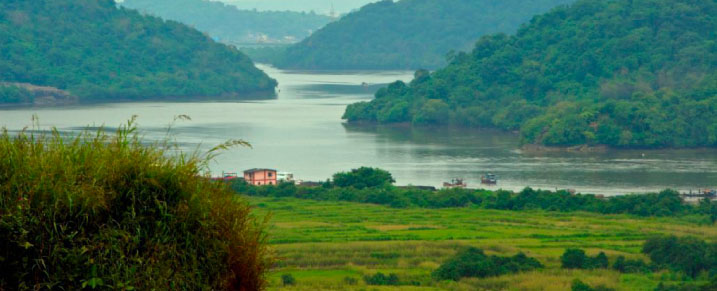 The Ulhas River, as seen from Ghodbunder


See also[edit | edit source]
References[edit | edit source]
- ↑ Lewis, Clara (18 March 2013). "Greens: Monitor discharge in Ulhas river". Mumbai: Times of India. Retrieved 14 July 2014.
- ↑ "District Census Handbook Thane" (PDF). Census of India. 2011. Archived from the original (PDF) on 16 November 2020.
- ↑ "MAHARASHTRA - DISTRICT CENSUS HANDBOOK" (PDF). Archived from the original (PDF) on 14 November 2016.
- ↑ Shetty, Nithi (20 February 2023). "The destruction of the Ulhas river: can we reverse it?". Citizen Matters. Retrieved 21 March 2026.


19°18′N 72°50′E / 19.300°N 72.833°E
 | This article about a location in the Indian state of Maharashtra is a stub. You can help Bharatpedia by expanding it. |