


->Jellysandwich0 mNo edit summary |
m expand layout additionally and added references for clarity |
||
| Line 4: | Line 4: | ||
{{Infobox settlement | {{Infobox settlement | ||
| name | | name = Vallikkunnu | ||
| native_name | | native_name = <!-- Please do not add any Indic script in this infobox, per WP:INDICSCRIPT policy. --> | ||
| native_name_lang | | native_name_lang = | ||
| other_name | | other_name = | ||
| nickname | | nickname = | ||
| settlement_type | | settlement_type = village | ||
| image_skyline | | image_skyline = Kadalundi Bird Sanctuary.jpg | ||
| image_alt | | image_alt = | ||
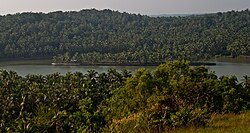
| image_caption | | image_caption = [[Kadalundi Bird Sanctuary]] is located in the Balathiruthi Island clusters of Vallikkunnu | ||
| pushpin_map | | pushpin_map = India Kerala#India | ||
| pushpin_label_position | | pushpin_label_position = right | ||
| pushpin_map_alt | | pushpin_map_alt = | ||
| pushpin_map_caption | | pushpin_map_caption = Location in Kerala, India | ||
| coordinates | | coordinates = {{coord|11|8|0|N|75|50|0|E|display=inline,title}} | ||
| subdivision_type | | subdivision_type = Country | ||
| subdivision_name | | subdivision_name = India | ||
| subdivision_type1 | | subdivision_type1 = [[States and territories of India|State]] | ||
| subdivision_name1 | | subdivision_name1 = [[Kerala]] | ||
| subdivision_type2 | | subdivision_type2 = [[List of districts of India|District]] | ||
| subdivision_name2 | | subdivision_name2 = [[Malappuram district|Malappuram]] | ||
| established_title | | established_title = <!-- Established --> | ||
| established_date | | established_date = | ||
| founder | | founder = | ||
| named_for | | named_for = | ||
| government_type | | government_type = | ||
| governing_body | | governing_body = | ||
| unit_pref | | unit_pref = Metric | ||
| area_footnotes | | area_footnotes = | ||
| area_rank | | area_rank = | ||
| area_total_km2 | | area_total_km2 = | ||
| elevation_footnotes | | elevation_footnotes = | ||
| elevation_m | | elevation_m = 2 | ||
| population_total | | population_total = 25448 | ||
| population_as_of | | population_as_of = 2011 | ||
| population_rank | | population_rank = | ||
| population_density_km2 | | population_density_km2 = auto | ||
| population_demonym | | population_demonym = | ||
| population_footnotes | | population_footnotes = | ||
| demographics_type1 | | demographics_type1 = Languages | ||
| demographics1_title1 | | demographics1_title1 = Official | ||
| demographics1_info1 | | demographics1_info1 = [[Malayalam language|Malayalam]], [[English language|English]] | ||
| timezone1 | | timezone1 = [[Indian Standard Time|IST]] | ||
| utc_offset1 | | utc_offset1 = +5:30 | ||
| postal_code_type | | postal_code_type = [[Postal Index Number|PIN]] | ||
| postal_code | | postal_code = 673314 | ||
| area_code_type | | area_code_type = Telephone code | ||
| area_code | | area_code = 0494 | ||
| registration_plate | | registration_plate = | ||
| blank1_name_sec1 | | blank1_name_sec1 = Nearest city | ||
| blank1_info_sec1 | | blank1_info_sec1 = Kozhikode | ||
| blank2_name_sec1 | | blank2_name_sec1 = [[Lok Sabha]] constituency | ||
| blank2_info_sec1 | | blank2_info_sec1 = [[Malappuram]] | ||
| blank3_name_sec1 | | blank3_name_sec1 = [[Vidhan Sabha]] constituency | ||
| blank3_info_sec1 | | blank3_info_sec1 = Vallikkunnu | ||
| blank1_name_sec2 | | blank1_name_sec2 = [[Climate of India|Climate]] | ||
| blank1_info_sec2 | | blank1_info_sec2 = [[Climatic regions of India|Moderate]] <small>([[Köppen climate classification|Köppen]])</small> | ||
| website | | website = | ||
| footnotes | | footnotes = | ||
}} | }} | ||
''' Vallikkunnu ''' is a village in [[Tirurangadi]] | ''' Vallikkunnu ''' is a village in [[Tirurangadi]] taluk of [[Malappuram district]] in the state of [[Kerala]], India with an area of 25 km<sup>2</sup>. It is located 5 km north of [[Parappanangadi]] town and falls under the jurisdiction of Parappanangadi Police Station and Parappanangadi Judicial First Class Magistrate Court. Vallikkunnu was awarded the best panchayath of Kerala in 1997.<ref name="censusindia">{{cite web|url=http://www.censusindia.gov.in/Census_Data_2001/Village_Directory/Population_data/Population_5000_and_Above.aspx|title=Census of India : Villages with population 5000 & above|last=Registrar General & Census Commissioner, India|access-date=2008-12-10}}</ref><ref>{{Cite web|url=https://www.mathrubhumi.com/election/2015/local-body/malappuram/vallikkunnu-grama-panchayat-malayalam-news-1.582652|title=വള്ളിക്കുന്ന് ഗ്രാമപഞ്ചായത്ത്|website=Mathrubhumi}}</ref> Vallikunnu is situated on [[Tirur]]-[[Kadalundi]] Road.<ref name="tps">{{Cite news|title=ആ ചൂളംവിളി പിന്നെയും പിന്നെയും...|url=https://www.mathrubhumi.com/malappuram/specials/50-years-of-malappuram/kerala-first-railway-line-tirur-to-beypore-1.3880175|date=17 June 2019|access-date=19 December 2020|work=Mathrubhumi|archive-date=7 May 2021|archive-url=https://web.archive.org/web/20210507072201/https://www.mathrubhumi.com/malappuram/specials/50-years-of-malappuram/kerala-first-railway-line-tirur-to-beypore-1.3880175|url-status=dead}}</ref> Vallikkunnu is also a part of the Oldest Railway Line of Kerala laid in 1861 from [[Tirur]] to [[Chaliyam]] via [[Tanur, Malappuram|Tanur]], [[Parappanangadi]], Vallikkunnu, and [[Kadalundi]].<ref name="tps"/> | ||
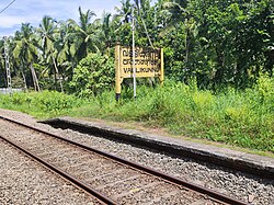
[[File:Vallikkunnu Railway Station.jpg|thumbnail|[[Vallikkunnu railway station]]]] | [[File:Vallikkunnu Railway Station.jpg|thumbnail|[[Vallikkunnu railway station]]]] | ||
[[File:A sunrise at Vallikkunnu.jpg|thumbnail|A sunrise at Vallikkunnu]] | [[File:A sunrise at Vallikkunnu.jpg|thumbnail|A sunrise at Vallikkunnu]] | ||
Vallikkunnu lies on the bank of [[Kadalundi River]]. Kadalundi River joins | Vallikkunnu lies on the bank of the [[Kadalundi River]]. Kadalundi River joins the [[Arabian Sea]] at the estuary (''Azhimukham'') in Kadalundi Nagaram beach of Vallikkunnu grama panchayat. [[Kadalundi Bird Sanctuary]] and Kadalundi-Vallikkunnu Community Reserve are located in Vallikkunnu.<ref name="Vallikkunnu">{{cite web |url=https://www.onmanorama.com/travel/kerala/2018/04/04/kadalundi-vallikunnu-community-reserve-ecotourism-centre.html |title=Kadalundi-Vallikkunnu community reserve |website=www.onmanorama.com |date=4 April 2018 |access-date=25 July 2020}}</ref> | ||
== Demographics == | == Demographics == | ||
{{As of| | {{As of|2011}} India [[census]], Vallikkunnu had a population of 25448 with 12019 males and 13429 females.<ref>{{Cite web |title=Vallikkunnu Village Population - Tirurangadi - Malappuram, Kerala |url=https://www.census2011.co.in/data/village/627539-vallikkunnu-kerala.html |access-date=2025-12-19 |website=www.census2011.co.in}}</ref><ref name="censusindia" /> | ||
It | It falls under Thirurangadi thaluk. Its northern boundary is [[Kadalundi river]] its southern boundary is with [[Parappanangadi]] Municipality. The village has a coastline of 8 kilometers with [[Arabian Sea]] in the west. It is bordered by [[Chelembra]], [[Tenhipalam]] and Moonniyoor Panchayaths.<ref>{{Cite web|url=http://www.ceo.kerala.gov.in/malappuram.html|title=CEO Kerala :: Malappuram|website=www.ceo.kerala.gov.in|access-date=28 November 2019|archive-date=20 August 2019|archive-url=https://web.archive.org/web/20190820130501/http://www.ceo.kerala.gov.in/malappuram.html|url-status=dead}}</ref><ref>{{Cite web|url=https://www.keralatourism.org/routes-locations/charamparambu--ii-/id/1907|title=Charamparambu (ii), Vallikkunnu Panchayat, Malappuram District, Kerala, India|website=Kerala Tourism}}</ref> | ||
== History == | == History == | ||
[[File:Periplous of the Erythraean Sea.svg|thumbnail|Names, routes and locations of the ''[[Periplus of the Erythraean Sea]]'' (1st century CE)]] | [[File:Periplous of the Erythraean Sea.svg|thumbnail|Names, routes and locations of the ''[[Periplus of the Erythraean Sea]]'' (1st century CE)]] | ||
[[File:Green Vallikkunnu.jpg|thumbnail|[[Mangrove]] plantation at Vallikunnu]] | [[File:Green Vallikkunnu.jpg|thumbnail|[[Mangrove]] plantation at Vallikunnu]] | ||
Vallikkunnu-[[Kadalundi]]-[[Chaliyam]]-[[Beypore]] had trade relations with foreign countries like Rome and Arabia since the era of king Solomon. [[Tyndis]], which was a major center of trade, next only to [[Muziris]], between the [[Chera dynasty|Chera]]s and the [[Roman Empire]], is identified with [[Kadalundi]].<ref>Coastal Histories: Society and Ecology in Pre-modern India, Yogesh Sharma, Primus Books 2010</ref> [[Pliny the Elder]] (1st century CE) states that the port of ''[[Tyndis]]'' was located at the northwestern border of ''Keprobotos'' ([[Chera dynasty]]).<ref name=":2">Gurukkal, R., & Whittaker, D. (2001). In search of Muziris. ''Journal of Roman Archaeology,'' ''14'', 334-350.</ref> The [[North Malabar]] region, which lies north of the port at ''[[Tyndis]]'', was ruled by the kingdom of [[Ezhimala]] during [[Sangam period]].<ref name="Malabar">A. Shreedhara Menon, A Survey of Kerala History</ref> According to the ''[[Periplus of the Erythraean Sea]]'', a region known as ''[[Limyrike]]'' began at ''[[Kannur|Naura]]'' and ''[[Tyndis]]''. However | Vallikkunnu-[[Kadalundi]]-[[Chaliyam]]-[[Beypore]] had trade relations with foreign countries like Rome and Arabia since the era of king Solomon. [[Tyndis]], which was a major center of trade, next only to [[Muziris]], between the [[Chera dynasty|Chera]]s and the [[Roman Empire]], is identified with [[Kadalundi]].<ref name="ReferenceA">Coastal Histories: Society and Ecology in Pre-modern India, Yogesh Sharma, Primus Books 2010</ref> [[Pliny the Elder]] (1st century CE) states that the port of ''[[Tyndis]]'' was located at the northwestern border of ''Keprobotos'' ([[Chera dynasty]]).<ref name=":2">Gurukkal, R., & Whittaker, D. (2001). In search of Muziris. ''Journal of Roman Archaeology,'' ''14'', 334-350.</ref> The [[North Malabar]] region, which lies north of the port at ''[[Tyndis]]'', was ruled by the kingdom of [[Ezhimala]] during [[Sangam period]].<ref name="Malabar">A. Shreedhara Menon, A Survey of Kerala History</ref> According to the ''[[Periplus of the Erythraean Sea]]'', a region known as ''[[Limyrike]]'' began at ''[[Kannur|Naura]]'' and ''[[Tyndis]]''. However [[Ptolemy]] mentions only ''[[Tyndis]]'' as the ''[[Limyrike]]'''s starting point. The region probably ended at [[Kanyakumari]]; it thus roughly corresponds to the present-day [[Malabar Coast]]. The value of Rome's annual trade with the region was estimated at 50,000,000 [[sesterces]].<ref>According to [[Pliny the Elder]], goods from India were sold in the Empire at 100 times their original purchase price. See [https://web.archive.org/web/20131106031753/http://www.cartage.org.lb/en/themes/BookLibrary/books/bibliographie/P/Plinyelder/elder/pliny-india.html]</ref> [[Pliny the Elder]] mentioned that ''[[Limyrike]]'' was prone by pirates.<ref>Bostock, John (1855). "26 (Voyages to India)". Pliny the Elder, The Natural History. London: Taylor and Francis.</ref> The [[Cosmas Indicopleustes]] mentioned that the ''[[Limyrike]]'' was a source of peppers.<ref>Indicopleustes, Cosmas (1897). Christian Topography. 11. United Kingdom: The Tertullian Project. pp. 358–373.</ref><ref>Das, Santosh Kumar (2006). The Economic History of Ancient India. Genesis Publishing Pvt Ltd. p. 301.</ref> | ||
According to the [[Legend of Cheraman Perumals]], the first Indian mosque was built in 624 AD at [[Kodungallur]] with the mandate of the last the ruler (the Cheraman Perumal) of [[Chera dynasty]], who converted to Islam during the lifetime of [[ | According to the [[Legend of Cheraman Perumals]], the first Indian mosque was built in 624 AD at [[Kodungallur]] with the mandate of the last the ruler (the Cheraman Perumal) of [[Chera dynasty]], who converted to Islam during the lifetime of [[Muhammad]] (c. 570–632).<ref>{{cite book |author=Jonathan Goldstein |title=The Jews of China |publisher=M. E. Sharpe |year=1999|isbn=9780765601049 |url=https://books.google.com/books?id=8Z6DlzyT2vwC |page=123}}</ref><ref name="SimpsonKresse2008">{{cite book |author1=Edward Simpson|author2=Kai Kresse|title=Struggling with History: Islam and Cosmopolitanism in the Western Indian Ocean|url=https://books.google.com/books?id=w0qHKA7zEaEC&pg=PA333|access-date=24 July 2012 |year=2008|publisher=Columbia University Press|isbn=978-0-231-70024-5|pages=333}}</ref><ref name="Kupferschmidt1987">{{cite book|author=Uri M. Kupferschmidt|title=The Supreme Muslim Council: Islam Under the British Mandate for Palestine|url=https://books.google.com/books?id=ChEVAAAAIAAJ&pg=PA458|access-date=25 July 2012|year=1987|publisher=Brill|isbn=978-90-04-07929-8|pages=458–459}}</ref><ref name="Raṇṭattāṇi2007">{{cite book|author=Husain Raṇṭattāṇi|title=Mappila Muslims: A Study on Society and Anti Colonial Struggles |url=https://books.google.com/books?id=xlb5BrabQd8C&pg=PA179|access-date=25 July 2012|year=2007|publisher=Other Books|isbn=978-81-903887-8-8|pages=179–}}</ref> According to ''[[Qissat Shakarwati Farmad]]'', the [[Mosque|''Masjids'']] at [[Kodungallur]], [[Kollam]], Madayi, [[Barkur]], [[Mangalore]], [[Kasaragod]], [[Kannur]], [[Dharmadam]], [[Koyilandy|Panthalayini]], and [[Chaliyam]] (just opposite to Vallikkunnu), were built during the era of [[Malik Dinar]], and they are among the oldest ''Masjid''s in the [[Indian subcontinent]].<ref>Prange, Sebastian R. ''Monsoon Islam: Trade and Faith on the Medieval Malabar Coast.'' Cambridge University Press, 2018. 98.</ref> It is believed that [[Malik Dinar]] died at [[Thalangara]] in [[Kasaragod]] town.<ref name="ch">Pg 58, Cultural heritage of [[Kerala]]: an introduction, A. Sreedhara Menon, East-West Publications, 1978</ref> | ||
After the breakdown of the Chera Kingdom dynasty rooted in Kadalundi, [[Parappanad]] Kovilakam of [[Parappanangadi]] became the rulers of Vallikkunnu. Parappanad royal family is a cousin dynasty of the [[Travancore royal family]].<ref name="Thrippadidaanam">{{cite book|last1=Mheshwari|first1=S Uma|title=Thrippadidaanam|publisher=Mathrubhumi Books|isbn=978-81-8265-947-6|pages=41–53}}</ref><ref>(See page 4 in Madras Presidency Records, 1915, Supt , Government Press, Madras.) </ref> They gave permission for the Dutch to build a fort at [[Kadalundi]]. Even though the fort collapsed after a war with Zamorins, we can see the remnants in Mulla. Later the British became the rulers of Vallikkunnu and they built railway lines from [[Tirur]] up to [[Chaliyam]] for the purpose of business. Later it was extended to [[Shoranur]]. [[Marthanda Varma]], the founder of [[Travancore]], belongs to [[Parappanad]] royal family.<ref name="Thrippadidaanam"/> | After the breakdown of the Chera Kingdom dynasty rooted in Kadalundi, [[Parappanad]] Kovilakam of [[Parappanangadi]] became the rulers of Vallikkunnu. Parappanad royal family is a cousin dynasty of the [[Travancore royal family]].<ref name="Thrippadidaanam">{{cite book|last1=Mheshwari|first1=S Uma|title=Thrippadidaanam|publisher=Mathrubhumi Books|isbn=978-81-8265-947-6|pages=41–53}}</ref><ref>(See page 4 in Madras Presidency Records, 1915, Supt , Government Press, Madras.)</ref> They gave permission for the Dutch to build a fort at [[Kadalundi]]. Even though the fort collapsed after a war with Zamorins, we can see the remnants in Mulla. Later the British became the rulers of Vallikkunnu and they built railway lines from [[Tirur]] up to [[Chaliyam]] for the purpose of business. Later it was extended to [[Shoranur]]. [[Marthanda Varma]], the founder of [[Travancore]], belongs to [[Parappanad]] royal family.<ref name="Thrippadidaanam"/> | ||
Thundi is an ancient seaport and harbor-town north of [[Muziris|Muziris (Muchiri)]] in the [[Chera Kingdom]] (Keprobotos), modern day [[India]] on the [[Malabar Coast]].<ref>{{cite web|author=The official web portal of Government of Kerala |url=http://www.kerala.gov.in/index.php?option=com_content&view=article&id=2852&Itemid=2291 |title=History |publisher=Kerala.gov.in |access-date=2012-09-21 |url-status=dead |archive-url=https://web.archive.org/web/20121009144939/http://kerala.gov.in/index.php?option=com_content&view=article&id=2852&Itemid=2291 |archive-date=2012-10-09 }}</ref><ref>{{cite web |author=The official web portal of Government of Kerala |url=http://www.kerala.gov.in |title=Official Web Portal of Government of Kerala |publisher=Kerala.gov.in |access-date=2012-09-21 |url-status=dead |archive-url=https://web.archive.org/web/20060118031516/http://www.kerala.gov.in/ |archive-date=2006-01-18 }}</ref> The exact location of the port is still unknown, modernday Kadalundi Nagaram, [[Ponnani]], [[Tanur, Malappuram|Tanur]], and [[Koyilandi|Pantalayani Kollam]]<ref>[http://www.kerala.gov.in/index.php?option=com_content&view=article&id=2852&Itemid=2291 History] {{webarchive|url=https://web.archive.org/web/20121009144939/http://kerala.gov.in/index.php?option=com_content&view=article&id=2852&Itemid=2291 |date=2012-10-09 }}.</ref> are often identified as Tyndis located in the [[Sangam period|Sangam age]] [[Tamil people|Tamil]] kingdom of the [[Chera dynasty|Cheras]]. Tyndis was a major center of trade, next only to Muziris, between the Cheras and the [[Roman Empire]] in the early centuries of the Christian era. A branch of the Chera royal family is also said to have established itself at Tyndis. It is also speculated that Tyndis (along with ports such as Naura, Bakare and Nelkynda) operated as a satellite feeding port to Muziris.<ref> | Thundi is an ancient seaport and harbor-town north of [[Muziris|Muziris (Muchiri)]] in the [[Chera Kingdom]] (Keprobotos), modern day [[India]] on the [[Malabar Coast]].<ref>{{cite web|author=The official web portal of Government of Kerala |url=http://www.kerala.gov.in/index.php?option=com_content&view=article&id=2852&Itemid=2291 |title=History |publisher=Kerala.gov.in |access-date=2012-09-21 |url-status=dead |archive-url=https://web.archive.org/web/20121009144939/http://kerala.gov.in/index.php?option=com_content&view=article&id=2852&Itemid=2291 |archive-date=2012-10-09 }}</ref><ref>{{cite web |author=The official web portal of Government of Kerala |url=http://www.kerala.gov.in |title=Official Web Portal of Government of Kerala |publisher=Kerala.gov.in |access-date=2012-09-21 |url-status=dead |archive-url=https://web.archive.org/web/20060118031516/http://www.kerala.gov.in/ |archive-date=2006-01-18 }}</ref> The exact location of the port is still unknown, modernday Kadalundi Nagaram, [[Ponnani]], [[Tanur, Malappuram|Tanur]], and [[Koyilandi|Pantalayani Kollam]]<ref>[http://www.kerala.gov.in/index.php?option=com_content&view=article&id=2852&Itemid=2291 History] {{webarchive|url=https://web.archive.org/web/20121009144939/http://kerala.gov.in/index.php?option=com_content&view=article&id=2852&Itemid=2291 |date=2012-10-09 }}.</ref> are often identified as Tyndis located in the [[Sangam period|Sangam age]] [[Tamil people|Tamil]] kingdom of the [[Chera dynasty|Cheras]]. Tyndis was a major center of trade, next only to Muziris, between the Cheras and the [[Roman Empire]] in the early centuries of the Christian era. A branch of the Chera royal family is also said to have established itself at Tyndis. It is also speculated that Tyndis (along with ports such as Naura, Bakare and Nelkynda) operated as a satellite feeding port to Muziris.<ref name="ReferenceA"/> | ||
'''Temples''' | |||
Vallikkunnu has several temples including Ravimngalam Vishnu temple and Nirankaitha Kotta. The annual Thalappoli Utsavam is one of the major religious festivals in this region, usually celebrated in the months of Feb-March.<ref>{{Cite web |title= |url=https://niramkaithakotta.com/}}</ref> | |||
==Wards of Vallikkunnu== | ==Wards of Vallikkunnu== | ||
| Line 91: | Line 95: | ||
}}</ref> | }}</ref> | ||
{|class="sortable | {| class="wikitable sortable" style="font-size: 95%;" | ||
!width="20px" |Ward no. | !width="20px" |Ward no. | ||
!width="75px" |Name | !width="75px" |Name | ||
| Line 164: | Line 168: | ||
* [[Chelembra]] | * [[Chelembra]] | ||
* [[Kadalundi Bird Sanctuary]] | * [[Kadalundi Bird Sanctuary]] | ||
* [[Kadalundi–Vallikkunnu Community Reserve]] | |||
* [[Chaliyar]] | * [[Chaliyar]] | ||
Latest revision as of 11:55, 6 March 2026
 | This article possibly contains original research. (July 2021) |
Vallikkunnu | |
|---|---|
village | |
 Kadalundi Bird Sanctuary is located in the Balathiruthi Island clusters of Vallikkunnu | |
  Vallikkunnu Location in Kerala, India  Vallikkunnu Vallikkunnu (India) | |
| Coordinates: 11°8′0″N 75°50′0″E / 11.13333°N 75.83333°E | |
| Country | India |
| State | Kerala |
| District | Malappuram |
| Elevation | 2 m (7 ft) |
| Population (2011) | |
| • Total | 25,448 |
| Languages | |
| • Official | Malayalam, English |
| Time zone | UTC+5:30 (IST) |
| PIN | 673314 |
| Telephone code | 0494 |
| Nearest city | Kozhikode |
| Lok Sabha constituency | Malappuram |
| Vidhan Sabha constituency | Vallikkunnu |
| Climate | Moderate (Köppen) |
Vallikkunnu is a village in Tirurangadi taluk of Malappuram district in the state of Kerala, India with an area of 25 km2. It is located 5 km north of Parappanangadi town and falls under the jurisdiction of Parappanangadi Police Station and Parappanangadi Judicial First Class Magistrate Court. Vallikkunnu was awarded the best panchayath of Kerala in 1997.[1][2] Vallikunnu is situated on Tirur-Kadalundi Road.[3] Vallikkunnu is also a part of the Oldest Railway Line of Kerala laid in 1861 from Tirur to Chaliyam via Tanur, Parappanangadi, Vallikkunnu, and Kadalundi.[3]


Vallikkunnu lies on the bank of the Kadalundi River. Kadalundi River joins the Arabian Sea at the estuary (Azhimukham) in Kadalundi Nagaram beach of Vallikkunnu grama panchayat. Kadalundi Bird Sanctuary and Kadalundi-Vallikkunnu Community Reserve are located in Vallikkunnu.[4]
Demographics[edit | edit source]
As of 2011[update] India census, Vallikkunnu had a population of 25448 with 12019 males and 13429 females.[5][1] It falls under Thirurangadi thaluk. Its northern boundary is Kadalundi river its southern boundary is with Parappanangadi Municipality. The village has a coastline of 8 kilometers with Arabian Sea in the west. It is bordered by Chelembra, Tenhipalam and Moonniyoor Panchayaths.[6][7]
History[edit | edit source]


Vallikkunnu-Kadalundi-Chaliyam-Beypore had trade relations with foreign countries like Rome and Arabia since the era of king Solomon. Tyndis, which was a major center of trade, next only to Muziris, between the Cheras and the Roman Empire, is identified with Kadalundi.[8] Pliny the Elder (1st century CE) states that the port of Tyndis was located at the northwestern border of Keprobotos (Chera dynasty).[9] The North Malabar region, which lies north of the port at Tyndis, was ruled by the kingdom of Ezhimala during Sangam period.[10] According to the Periplus of the Erythraean Sea, a region known as Limyrike began at Naura and Tyndis. However Ptolemy mentions only Tyndis as the Limyrike's starting point. The region probably ended at Kanyakumari; it thus roughly corresponds to the present-day Malabar Coast. The value of Rome's annual trade with the region was estimated at 50,000,000 sesterces.[11] Pliny the Elder mentioned that Limyrike was prone by pirates.[12] The Cosmas Indicopleustes mentioned that the Limyrike was a source of peppers.[13][14]
According to the Legend of Cheraman Perumals, the first Indian mosque was built in 624 AD at Kodungallur with the mandate of the last the ruler (the Cheraman Perumal) of Chera dynasty, who converted to Islam during the lifetime of Muhammad (c. 570–632).[15][16][17][18] According to Qissat Shakarwati Farmad, the Masjids at Kodungallur, Kollam, Madayi, Barkur, Mangalore, Kasaragod, Kannur, Dharmadam, Panthalayini, and Chaliyam (just opposite to Vallikkunnu), were built during the era of Malik Dinar, and they are among the oldest Masjids in the Indian subcontinent.[19] It is believed that Malik Dinar died at Thalangara in Kasaragod town.[20]
After the breakdown of the Chera Kingdom dynasty rooted in Kadalundi, Parappanad Kovilakam of Parappanangadi became the rulers of Vallikkunnu. Parappanad royal family is a cousin dynasty of the Travancore royal family.[21][22] They gave permission for the Dutch to build a fort at Kadalundi. Even though the fort collapsed after a war with Zamorins, we can see the remnants in Mulla. Later the British became the rulers of Vallikkunnu and they built railway lines from Tirur up to Chaliyam for the purpose of business. Later it was extended to Shoranur. Marthanda Varma, the founder of Travancore, belongs to Parappanad royal family.[21]
Thundi is an ancient seaport and harbor-town north of Muziris (Muchiri) in the Chera Kingdom (Keprobotos), modern day India on the Malabar Coast.[23][24] The exact location of the port is still unknown, modernday Kadalundi Nagaram, Ponnani, Tanur, and Pantalayani Kollam[25] are often identified as Tyndis located in the Sangam age Tamil kingdom of the Cheras. Tyndis was a major center of trade, next only to Muziris, between the Cheras and the Roman Empire in the early centuries of the Christian era. A branch of the Chera royal family is also said to have established itself at Tyndis. It is also speculated that Tyndis (along with ports such as Naura, Bakare and Nelkynda) operated as a satellite feeding port to Muziris.[8]
Temples
Vallikkunnu has several temples including Ravimngalam Vishnu temple and Nirankaitha Kotta. The annual Thalappoli Utsavam is one of the major religious festivals in this region, usually celebrated in the months of Feb-March.[26]
Wards of Vallikkunnu[edit | edit source]

Vallikkunnu Grama Panchayat is composed of the following 23 wards:[27]
| Ward no. | Name | Ward no. | Name |
|---|---|---|---|
| 1 | Kadalundi Nagaram North | 2 | Keezhayil |
| 3 | Navajeevan | 4 | Balathiruthi |
| 5 | Anayarangadi | 6 | Madathil Purayi |
| 7 | Kizhakkemala | 8 | Olipram |
| 9 | Paruthikkad | 10 | Pottenkuzhi |
| 11 | Kacherikunnu | 12 | Karumarakkad |
| 13 | Kodakkad East | 14 | Kodakkad South |
| 15 | Kodakkad West | 16 | Ariyallur East |
| 17 | Madhavanandam | 18 | Ariyallur South |
| 19 | Ariyallur Beach | 20 | Ariyallur North |
| 21 | Anangadi South | 22 | Anangadi |
| 23 | Kadalundi Nagaram |
See also[edit | edit source]
- Parappanangadi
- Chelari
- Tenhipalam
- Chelembra
- Kadalundi Bird Sanctuary
- Kadalundi–Vallikkunnu Community Reserve
- Chaliyar
External links[edit | edit source]
References[edit | edit source]
- ↑ 1.0 1.1 Registrar General & Census Commissioner, India. "Census of India : Villages with population 5000 & above". Retrieved 10 December 2008.
- ↑ "വള്ളിക്കുന്ന് ഗ്രാമപഞ്ചായത്ത്". Mathrubhumi.
- ↑ 3.0 3.1 "ആ ചൂളംവിളി പിന്നെയും പിന്നെയും..." Mathrubhumi. 17 June 2019. Archived from the original on 7 May 2021. Retrieved 19 December 2020.
- ↑ "Kadalundi-Vallikkunnu community reserve". www.onmanorama.com. 4 April 2018. Retrieved 25 July 2020.
- ↑ "Vallikkunnu Village Population - Tirurangadi - Malappuram, Kerala". www.census2011.co.in. Retrieved 19 December 2025.
- ↑ "CEO Kerala :: Malappuram". www.ceo.kerala.gov.in. Archived from the original on 20 August 2019. Retrieved 28 November 2019.
- ↑ "Charamparambu (ii), Vallikkunnu Panchayat, Malappuram District, Kerala, India". Kerala Tourism.
- ↑ 8.0 8.1 Coastal Histories: Society and Ecology in Pre-modern India, Yogesh Sharma, Primus Books 2010
- ↑ Gurukkal, R., & Whittaker, D. (2001). In search of Muziris. Journal of Roman Archaeology, 14, 334-350.
- ↑ A. Shreedhara Menon, A Survey of Kerala History
- ↑ According to Pliny the Elder, goods from India were sold in the Empire at 100 times their original purchase price. See [1]
- ↑ Bostock, John (1855). "26 (Voyages to India)". Pliny the Elder, The Natural History. London: Taylor and Francis.
- ↑ Indicopleustes, Cosmas (1897). Christian Topography. 11. United Kingdom: The Tertullian Project. pp. 358–373.
- ↑ Das, Santosh Kumar (2006). The Economic History of Ancient India. Genesis Publishing Pvt Ltd. p. 301.
- ↑ Jonathan Goldstein (1999). The Jews of China. M. E. Sharpe. p. 123. ISBN 9780765601049.
- ↑ Edward Simpson; Kai Kresse (2008). Struggling with History: Islam and Cosmopolitanism in the Western Indian Ocean. Columbia University Press. p. 333. ISBN 978-0-231-70024-5. Retrieved 24 July 2012.
- ↑ Uri M. Kupferschmidt (1987). The Supreme Muslim Council: Islam Under the British Mandate for Palestine. Brill. pp. 458–459. ISBN 978-90-04-07929-8. Retrieved 25 July 2012.
- ↑ Husain Raṇṭattāṇi (2007). Mappila Muslims: A Study on Society and Anti Colonial Struggles. Other Books. pp. 179–. ISBN 978-81-903887-8-8. Retrieved 25 July 2012.
- ↑ Prange, Sebastian R. Monsoon Islam: Trade and Faith on the Medieval Malabar Coast. Cambridge University Press, 2018. 98.
- ↑ Pg 58, Cultural heritage of Kerala: an introduction, A. Sreedhara Menon, East-West Publications, 1978
- ↑ 21.0 21.1 Mheshwari, S Uma. Thrippadidaanam. Mathrubhumi Books. pp. 41–53. ISBN 978-81-8265-947-6.
- ↑ (See page 4 in Madras Presidency Records, 1915, Supt , Government Press, Madras.)
- ↑ The official web portal of Government of Kerala. "History". Kerala.gov.in. Archived from the original on 9 October 2012. Retrieved 21 September 2012.
- ↑ The official web portal of Government of Kerala. "Official Web Portal of Government of Kerala". Kerala.gov.in. Archived from the original on 18 January 2006. Retrieved 21 September 2012.
- ↑ History Archived 2012-10-09 at the Wayback Machine.
- ↑ https://niramkaithakotta.com/.
{{cite web}}: Missing or empty|title=(help) - ↑ "Wards of Vallikkunnu". sec.kerala.gov.in.

.png)