→See also: spelling |
ChristinaQ73 (talk | contribs) m fixed issues |
||
| Line 1: | Line 1: | ||
{{Use dmy dates|date= | {{Short description|Proposed border highway in Arunachal Pradesh, India}} | ||
{{Use Indian English|date= | {{Use dmy dates|date=November 2025}} | ||
{{Use Indian English|date=November 2025}} | |||
{{infobox road | {{infobox road | ||
|header_type=UC | |header_type=UC | ||
|country=IND | |country=IND | ||
|name = | |name = Arunachal Frontier Highway | ||
|map= | |map= | ||
|map_notes= | |map_notes= | ||
|length_km= | |length_km= 1748 | ||
|direction_a= West | |direction_a= West | ||
|direction_b= East | |direction_b= East | ||
|terminus_a= [[ | |terminus_a= [[Bomdila]] in [[West Kameng district]] | ||
|junction= | |junction= | ||
|terminus_b= [[Vijaynagar, Changlang|Vijaynagar]] in [[Changlang district]] | |terminus_b= [[Vijaynagar, Changlang district|Vijaynagar]] in [[Changlang district]] | ||
|formed= | |formed= | ||
|history= | |history= | ||
|states= [[Arunachal Pradesh]] | |states= [[Arunachal Pradesh]] | ||
|cities=[[ | |cities= Nafra, Sarli, Huri, [[Mechuka]], [[Tuting]], [[Hunli]], [[Hayuliang]], [[Hawai, Arunachal Pradesh|Hawai]], [[Miao, Arunachal Pradesh|Miao]], [[Kharsang]], | ||
|maint= | |maint= | ||
}} | }} | ||
'''Arunachal Frontier Highway''', | '''Arunachal Frontier Highway''', officially notified as the '''National Highway-913''' and also called Bomdila-Vijaynagar Highway, connecting [[Bomdila]] in northwest to [[Vijaynagar, Changlang district|Vijaynagar]] in southeast including 800 km greenfield section and network of new tunnels & bridges, is mostly [[Roads_in_India#LW|lntermediate-lane]] (5.5 m or 18 ft) and in some sections 2-lane paved-shoulder under-construction national highway along the [[McMahon Line|India-Tibet border]] in the Indian state of [[Arunachal Pradesh]]. The {{convert|1,748|km|mi|abbr=on|adj=mid|-long}} highway itself will cost {{INRConvert|27000|c|currency_formatting=c|lk=on|to=USD|year=2022}} and total cost including 6 additional inter-corridors is {{INRConvert|40000|c|currency_formatting=c|lk=on|to=USD|year=2022}}. | ||
The highway along the China border would | In some places, this highway will run as close as 20 km from the LAC. To be constructed by [[Ministry of Road Transport and Highways|MoRTH]] in 9 packages, all packages will be approved by the end of FY 2024-25 (March 2025) and construction will be completed in 2 years by 31 March 2027.<ref name=wionfh1>{{cite web | url= | ||
https://timesofindia.indiatimes.com/india/eye-on-china-govt-plans-a-1700-km-frontier-highway/articleshow/96326206.cms | title= Eye on China, govt plans a 1,700-km 'frontier highway' | publisher= Times of India | access-date= 19 December 2022}}</ref><ref name=wionfh2>{{cite web | url= https://www.wionews.com/india-news/as-lac-skirmishes-increase-india-to-build-a-1700-km-highway-in-arunachal-pradesh-544428 | title= As LAC skirmishes increase, India to build a 1,700-km highway in Arunachal Pradesh. | publisher=WION | access-date= 19 December 2022}}</ref><ref name="BR7">{{cite web | url=http://www.dnaindia.com/india/report-narendra-modi-government-to-provide-funds-for-restoration-of-damaged-highways-2020106 | title=Narendra Modi government to provide funds for restoration of damaged highways | publisher=Diligent Media Corporation Ltd | access-date=27 October 2014}}</ref><ref name=BR1>{{cite news|title=Top officials to meet to expedite road building along China border|url=https://timesofindia.indiatimes.com/india/Top-officials-to-meet-to-expedite-road-building-along-China-border/articleshow/44831871.cms|first=Dipak Kumar|last=Dash|newspaper=The Times of India|access-date=26 May 2019}}</ref><ref name=BR3>{{cite web|title=Indian Government Plans Highway Along Disputed China Border|url=https://thediplomat.com/2014/10/indian-government-plans-highway-along-disputed-china-border/|work=Ankit Panda|publisher=thediplomat.com|access-date=27 October 2014}}</ref><ref name=BR2>{{cite web |url= http://www.livemint.com/Politics/nqEwdXxkIgrSHPpTSzsFRN/Govt-planning-road-along-McMohan-line-in-Arunachal-Pradesh.html |title= Govt planning road along McMohan line in Arunachal Pradesh: Kiren Rijiju |date= 14 October 2014 |publisher= Live Mint |access-date= 26 October 2014}}</ref> Of the total route, 800km is greenfield, rest brownfield will be upgraded and tunnels will be built.<ref name=hinn1>[https://hindi.news18.com/news/nation/border-with-china-in-north-east-more-secure-1748-km-lfrontier-highway-built-spending-27000-crores-5075205.html नॉर्थ ईस्ट में चीन के साथ लगी सीमा होगी और सुरक्षित, 27000 करोड़ खर्च कर बनेगा 1748 KM लंबा 'फंटियर हाईवे'], News18, 19 December 2022.</ref> This highway in the north & east Arunachal along the China border would complement the [[Trans-Arunachal Highway]] (through the middle of Arunachal) and the [[East-West Industrial Corridor Highway, Arunachal Pradesh|Arunachal East-West Corridor]] (in south Arunachal in foothills along the Assam border) as major highways spanning the whole state, pursuing the [[Ministry_for_Development_of_North_Eastern_Region#Northeast_India_connectivity_projects|Look East connectivity]] policy.<ref name=kn1>[https://www.northeasttoday.in/arunachal-dy-cm-lays-foundation-stone-of-bridge-over-bari-river/ Arunachal Dy CM Lays Foundation Stone of Bridge over Bari River] {{Webarchive|url=https://web.archive.org/web/20171222051151/https://www.northeasttoday.in/arunachal-dy-cm-lays-foundation-stone-of-bridge-over-bari-river/ |date=22 December 2017 }}, North East Today, 11 December 2017.</ref><ref>{{Cite web |date=13 July 2024 |title=Arunachal Frontier Highway - Route Map, Cost, Progress, and More - Infra Info Hub |url=https://infrainfohub.com/arunachal-frontier-highway/ |access-date=13 July 2024 |language=en-US}}</ref> | |||
== | ==History== | ||
===Conveived === | |||
In 2016, ''empowered committee on border infrastructure'' asked the MoRTH to prepare the detailed project reports (DPR) as per the alignment agreed by the home ministry, defence ministry & Arunachal state government. In 2018, Home ministry enhanced the alignment for the additional connectivity.<ref name=wionfh1/><ref name=wionfh2/> MoRTH identifies the highway as one of the 29 corridors close to the 3,600 km international border, to be undertaken as a [[National Highway Development Project|NHDP]] (which has been subsumed by the [[Bharatmala]] project), though there is "little habitation" along the proposed route and only "small stretches of minor roads".<ref name=BR1/> | |||
The highway will cross the [[Dibang Wildlife Sanctuary]], which may | ===Construction=== | ||
<!--NOTE: Add details of each construction package once that information is released by the government. --> | |||
It will be constructed in the following nine packages,<ref name=rfp1>[https://morth.nic.in/invitation-rfp-consultancy-services-preparation-dpr-frontier-highway-nafra-vijaynagar-state Frontier Highway], MoRTH, accessed 8 February 2024.</ref> all approvals and land acquisition will be progressively completed by March 2025, and the construction will be progressively completed by March 2027<ref name=wionfh1/><ref name=wionfh2/> in fully government-funded "engineering procure and construct" (EPC) mode.<ref name=toipak1/> | |||
* '''Package-1 Nafra–Lada, 141 km''' (Nafra–Dibrick–Sachung–Lada):<ref name=rfp1/> full budget approved in 2023. | |||
* '''Package-2 Lada–Sarli, 200 km''':<ref name=rfp1/> for 106 km budget of ₹ 2,249 crore approved in Feb 2024.<ref name=toipak1>[https://timesofindia.indiatimes.com/india/rs-3890-crore-sanctioned-for-three-packages-of-strategic-frontier-highway-in-arunachal-that-will-run-close-to-border/articleshow/107467677.cms Sources said so far the ministry has approved works for around 500 km of the 1,748 km], Times of India, 6 February 2024.</ref> | |||
* '''Package-3 Sarli-Tali, 201 km''' (Sarli-Huri–Parsi Parlo–Tali):<ref name=rfp1/> | |||
** ''Sarli-Huri'': for 35 km a budget of ₹626.92 crore approved in Feb 2024.<ref name=toipak1/> | |||
* '''Package-4 Tali–Mechuka, 225 km''' (Tali–Taliha–Siyum–Mechuka):<ref name=rfp1/> | |||
* '''Package-5 Mechuka–Bile, 183 km''' (Mechuka–Tato–Monigong–Tato–Bile):<ref name=rfp1/> | |||
* '''Package-6 Bile–Hunli, 230 km''' (Bile–Migging–Tuting–Singa–Anelye–Hunli):<ref name=rfp1/> | |||
* '''Package-7 Hunli–Hayuliang, 186 km''':<ref name=rfp1/> | |||
* '''Package-8: Hayuliang–Miao, 285 km''' (Hayuliang–Changwinti–Hawai–Miao):<ref name=rfp1/> | |||
* '''Package-9 Miao–Vijaynagar, 157 km''' (Miao–Gandhigramm–Vijaynagar):<ref name=rfp1/> | |||
** ''Kharsang-Gandhigram'': for 61.5 km a budget of Rs 1,015 crore approved in Feb 2024.<ref name=toipak1/><ref>{{Cite web|url=https://thenewsmill.com/2024/02/centre-approves-another-rs-2378-72-crore-for-construction-of-frontier-highway-in-arunachal/,%20https://thenewsmill.com/2024/02/centre-approves-another-rs-2378-72-crore-for-construction-of-frontier-highway-in-arunachal/|title=Centre approves another Rs 2378.72 crore for construction of Frontier Highway in Arunachal|first=T. N. M.|last=NewsDesk|date=12 February 2024|website=thenewsmill.com|accessdate=16 February 2024}}</ref> | |||
==Details == | |||
===Benefits=== | |||
Various sources in the [[Government of India]] and media have mentioned the following reasons to build the highway:<ref name=BR1/><ref name=BR3/><ref name=BR2/><ref name=BR4/> | |||
* Highway will generate employment and increase tourism in these hard-to-reach areas. | |||
* Highway will check Chinese incursions into Indian territory. China has built an extensive road and railway network on its side, posing a security risk to India as the region is relatively inaccessible on the Indian side. | |||
===Wildlife protection === | |||
{{anchor | Wild | Wildlife }} | |||
India's [[National Board for Wildlife]] approved diversion of 310 hectares of [[Namdapha National Park]] - habitat for [[Tigers in India|tigers]] (India is home to 76% of world's tiger population), [[clouded leopard]]s, and [[red panda]]s (only panda species in India) - forest land for this highway for boosting state's remotest habitation's socio-economic development. The wildlife protection is a major consideration for the project, and to ensure the wildlife movement corridors are not disrupted by the highway the wildlife passage culverts and underpasses customised to the site-specific data-backed research have been constructed.<ref name=aqw1>[https://aquireacres.com/arunachal-frontier-highway-a-journey-beyond-the-ordinary Arunachal Frontier Highway A Journey Beyond the Ordinary], AquireAcres.com, 30 October 2025.</ref> The highway will also cross the [[Dibang Wildlife Sanctuary]]. | |||
==Route== | |||
===Main route (approved)=== | |||
{{anchor | Main }} | |||
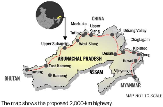
The high-altitude highway will originate from [[Mago, Tawang|Mago]]-[[Thingbu]] in [[Tawang district]] and meander through the following border areas of Arunachal Pradesh along the McMahon Line: [[West Kameng district]]; [[East Kameng district]]; [[Upper Subansiri district]]; [[Mechuka]] in [[West Siang district]]; [[Tuting]] in [[Upper Siang district]]; [[Dibang Valley district]]; [[Desali]] in [[Lower Dibang Valley district]]; [[Chaglagam]], [[Kibithu]], [[Dong, Arunachal Pradesh|Dong]] and [[Hawai, India|Hawai]] all in [[Anjaw district]]; and end at [[Vijaynagar, Changlang|Vijaynagar]] in [[Changlang district]] at the junction of Arunachal Pradesh, [[Assam]], [[Nagaland]] and [[Myanmar]].<ref name=BR3/><ref name=BR6/> The map of alignment can be seen [http://www.tribuneindia.com/2014/20141016/nat7.jpg here].<ref name=BR6>{{cite web |url= http://www.tribuneindia.com/2014/20141016/nation.htm|title=China warns India against paving road in Arunachal|work=Ajay Banerjee|publisher=tribuneindia.com|access-date= 26 October 2014}}</ref> | |||
Alignment by district, from west to east:<ref name=wionfh1/><ref name=wionfh2/> | |||
====Western Arunachal Pradesh ==== | |||
{{anchor | West | Western }} | |||
* [[West Kameng district]] (capital [[Bomdila]]) | |||
** [[Bomdila]] - aviation ministry is planning an airport in Dirang just northeast of Bomdila | |||
** [[Thembang]] HQ, north of Bomdila. | |||
** [[Nafra]]<!--NOTE: Please retain the red link to encourage article creation.--> Heliport ALG & HQ, east of Thembang & Bomdila. | |||
** [[Dishing]], north of Nafra in Nafra circle. | |||
** [[Wothung]], northeast of Dishing in Nafra circle. | |||
* [[East Kameng district]] (capital [[Seppa]]) | |||
** [[Nissangjang]] in Lada circle, northeast of Wothung & Nafra. | |||
** [[Lada, Arunachal|Lada]] Heliport ALG & HQ, north of district HQ Seppa. | |||
** [[Bameng]]<!--NOTE: Please retain the red link to encourage article creation.--> Heliport ALG & HQ, southeast of Lada. | |||
** [[Sawa, Arunachal|Sawa]] Heliport ALG & HQ, northeast of Bameng | |||
** [[Chayangtajo]] Heliport ALG & HQ, northeast of Sawa. | |||
====Central Arunachal Pradesh ==== | |||
{{anchor | Central | Middle }} | |||
* [[Kurung Kumey district]] (capital [[Koloriang]]) | |||
** [[Koloriang]] Heliport ALG & district HQ, northeast of Chayangtajo. | |||
** [[Sarli, Arunachal|Sarli]] Heliport ALG & HQ,<!--NOTE: Please retain the red link to encourage article creation.--> northwest of Koloriang. | |||
** [[Huri, Arunachal|Huri]]<!--NOTE: Please retain the red link to encourage article creation.--> Heliport ALG in Huri-Damin circle, northeast of Sarli. | |||
** [[Damin, Arunachal|Damin]]<!--NOTE: Please retain the red link to encourage article creation.--> Heliport ALG in Huri-Damin circle, east of Huri. | |||
* [[Upper Subansiri district]] (capital [[Daporijo]] Airport ALG) | |||
** [[Nacho, Arunachal Pradesh|Nacho]] Heliport ALG & HQ, northeast of Huri & Damin. | |||
* [[West Siang district]] (capital [[Aalo]] Airport ALG) | |||
** [[Mechuka Advanced Landing Ground|Mechuka]] Airstrip ALG & HQ, north of Manigong. | |||
** [[Monigong]]<!--NOTE: Please retain the red link to encourage article creation.--> Heliport ALG & HQ, east of Nacho. | |||
====Eastern Arunachal Pradesh ==== | |||
{{anchor | East | Eastern }} | |||
* [[Upper Siang district]] (capital [[Yingkiong]]) | |||
** [[Tuting Advanced Landing Ground|Jido (Tuting Airstrip ALG)]]<!--NOTE: Please retain the red link to encourage article creation.--> & HQ, east of Mechuka. | |||
** [[Singa, Arunachal Pradesh|Singa]], southeast of Tuting. | |||
* [[Dibang Valley district]] (capital [[Anini]] under-construction Airport ALG) | |||
** [[Cheppe]], in Anelih circle and southeast of Singa. | |||
** [[Anelih]] HQ, southeast of Singa. | |||
* [[Lower Dibang Valley district]] (capital [[Roing]] Airport ALG) | |||
** [[Hunli]] Heliport ALG & HQ, southeast of Anelih. | |||
** [[Desali, Arunachal|Desali]] HQ, east of Hunli. | |||
* [[Anjaw district]] (capital [[Hawai, Arunachal Pradesh|Hawai]]) | |||
** [[Hayuliang]] Airport ALG & HQ. | |||
** [[Manchal, Arunachal Pradesh|Manchal]] Heliport ALG & HQ. | |||
** [[Hawai, Arunachal Pradesh|Hawai]] Heliport ALG & HQ. | |||
====Southeastern Arunachal Pradesh ==== | |||
{{anchor | SE | Southeast | Southeastern }} | |||
* [[Changlang district]] (capital [[Changlang]]) | |||
** [[Miao, Arunachal Pradesh|Miao]] HQ | |||
***{{anchor|MKS}} [[Kharsang]] HQ, Miao-Kharsang spur. | |||
** [[Chenquenty]] | |||
** [[Vijaynagar, Changlang|Vijaynagar Airstrip ALG]], Miao-Vijaynagar route. | |||
===Six Inter-corridor highways (approved)=== | |||
{{anchor | ic | IC | ich | ICH | Inter | Inter-corridor | Inter corridor | Inter-Corridor | Inter Corridor | Corridor }} | |||
To providing missing interconnectivity between three horizontal national highways across Arunachal Pradesh - Frontier Highway, Trans-Arunachal Highway and East-West Industrial Corridor Highway - following six vertical and diagonal national highway corridors of total 2178 km length will be built, which will also provide faster access to geostrategically important areas on India-China LAC.<ref name=ir1>[https://economictimes.indiatimes.com/industry/transportation/roadways/arunachal-pradesh-inter-corridors-between-two-highways-proposed/articleshow/94995545.cms Arunachal Pradesh: Inter-corridors between two highways proposed], Economic Times, 20 October 2022.</ref><ref name=ir2>[https://www.ndtv.com/india-news/centre-proposes-missing-link-connectivity-of-roads-in-arunachal-near-china-border-3454075#comments_result Centre Clears Construction Of 6 Corridors In Arunachal Near China Border], NDTV, 20 October 2022.</ref> | |||
Listed west to east and within that south to north. | |||
====Thelamara-Tawang-Nelia==== | |||
{{anchor | TTN }} | |||
Runs along [[Thelamara]]<!-- NOTE: Retain redlink to encourage article creation. -->-[[Tawang]]-[[Nelia, Arunachal|Nelia]]<!-- NOTE: Retain redlink to encourage article creation. --> for 402 km.<ref name=ir2/> | |||
====Itakhola-Seppa-Parsi Parlo==== | |||
{{anchor | TSPP}} | |||
Runs along [[Itakhola]]<!-- NOTE: Retain redlink to encourage article creation. -->-[[Pakke-Kessang]]-[[Seppa]]-[[Parsi Parlo]]<!-- NOTE: Retain redlink to encourage article creation. --> for 391 km.<ref name=ir2/> | |||
====Gogamukh-Taliha-Tato==== | |||
{{anchor | GTT}} | |||
Runs along [[Gogamukh]]<!-- NOTE: Retain redlink to encourage article creation. -->-[[Taliha]]<!-- NOTE: Retain redlink to encourage article creation. -->-[[Tato, Arunachal|Tato]]<!-- NOTE: Retain redlink to encourage article creation. --> for 285 km.<ref name=ir2/> | |||
====Akajan-Jorging-Pango==== | |||
{{anchor | AJP }} | |||
Runs along [[Akajan]]<!-- NOTE: Retain redlink to encourage article creation. -->-[[Jorging]]<!-- NOTE: Retain redlink to encourage article creation. -->-[[Pango, Arunachal|Pango]]<!-- NOTE: Retain redlink to encourage article creation. --> for 398 km.<ref name=ir2/> | |||
====Pasighat-Bishing==== | |||
{{anchor | PB }} | |||
Runs along [[Pasighat]]-[[Bishing]] for 298 km.<ref name=ir2/> | |||
====Kanubari-Longding==== | |||
{{anchor | KL }} | |||
Runs along [[Kanubari]]-[[Longding]] for 404 km.<ref name=ir2/> | |||
===Proposed spurs (awaiting approval)=== | |||
{{anchor | Spur | Spurs }} | |||
Listed west to east. | |||
====Tawang-Yongphulla Spur (awaiting approval)==== | |||
{{anchor | TYS}} | |||
'''Tawang-Yongphulla Highway''' spur, proposed as a 100 km long western spur from [[Tawang]] to [[Yongphulla Airport]] in Bhutan (upgraded by India and jointly used by the Indian Army and Bhutan Army)<ref>{{cite web|title=Dantak|work=Border Roads Organisation|publisher=[[Government of India]]|url=http://www.bro.nic.in/indexmain.asp?projectid=23|access-date=1 November 2011|url-status=dead|archive-url=https://web.archive.org/web/20110927154718/http://www.bro.nic.in/indexmain.asp?projectid=23|archive-date=27 September 2011}}</ref> in eastern Bhutan via [[Lumla]]-Yabab in India and [[Trashigang]] in Bhutan. | |||
====Miao-Kharsang spur (approval-unknown)==== | |||
'''[[Arunachal_Frontier_Highway#MKS|Miao-Kharsang Highway]]''' spur is likely awaiting approval as the National Highway, though state-level lower-status connectivity plan may exist (Nov 2025 update). | |||
==Connectivity== | |||
=== VVP feeder roads (approved)=== | |||
{{anchor | VVP }} | |||
Under the [[India–China_border_infrastructure#VVP|Vibrant Villages Programme]], feeder roads to 122 border villages in Arunachal, at the cost of ₹2,205 crore, are being constructed which will connect to the Arunachal Frontier Highway. This budget also includes community centers and public infrastructure in those villages along the India-Tibet border to empower the villagers.<ref name=aqw1/> | |||
=== Within Arunachal Pradesh === | |||
{{anchor | APconnect}} | |||
Arunachal Frontier Highway will intersect with the: | |||
====Trans-Arunachal Highway (approved)==== | |||
See [[Trans-Arunachal Highway]]. | |||
====East-West Industrial Corridor Highway (awaiting approval)==== | |||
See [[East-West Industrial Corridor Highway, Arunachal Pradesh|East-West Industrial Corridor Highway]] in the foothills of [[Arunachal Pradesh]] from [[Bhairabkunda]], the tri-junction of [[Bhutan]], [[Assam]] and [[Arunachal Pradesh]] to [[Ruksin]] in [[East Siang district]].<ref name=BR7/> | |||
=== National connectivity (awaiting approval)=== | |||
{{anchor | NatCon | NatConnect | NationalConnect | NationalConnectivity }} | |||
Arunachal Frontier Highway will also connect with the proposed ''Brahmaputra Expressway'', running largely through Assam along the [[Brahmaputra River]].<ref name=aqw1/> | |||
=== Inter-national connectivity (awaiting approval)=== | |||
{{anchor | IntNatCon | IntNatConnect | IntNationalConnect | InterNationalConnectivity }} | |||
{{see also | Asian Highway Network }} | |||
* [[Bangladesh-China-India-Myanmar Forum for Regional Cooperation#BCIM Economic Corridor|BCIM Economic Corridor]] (BCIMEC) proposed by the [[Bangladesh-China-India-Myanmar Forum for Regional Cooperation]] (BCIM Forum) encompasses the Arunachal Frontier Highway.<ref name=BR7/><ref name=BR1/> BCIMEC is a multi-mode corridor that includes a highway from [[Calcutta]] in India's [[West Bengal]] state to [[Kunming]] in China's [[Yunnan]] province. As well as Arunachal Pradesh, the highway passes through the Indian states of [[Manipur]] and [[Assam]].<ref name="BR4">{{cite web | url=https://www.bbc.com/news/world-asia-india-29639950 | title=Why India is planning a new road near the China border | publisher=[[BBC]] | work=BBC News | date=16 October 2014 | access-date=27 October 2014}}</ref> | |||
==Tourism == | |||
{{ see also | Tourism in Northeast India }} | |||
* '''Swadesh Darshan Tourist Circuits along the highways in Arunachal:''' In 2015 under the [[Swadesh Darshan Scheme]], the Indian approved the funds to develop the following two tourist circuits in Arunachal Pradesh:<ref name=artu1/> | |||
** '''"Bhalukpong-Bomdila-Tawang Tourist Circuit"''' along the Arunachal Frontier Highway at the cost of ₹49.77 crore: The ''"facilities like accommodation, cafeteria, wayside amenities, last mile connectivity, pathways, toilet were built at Sorang Monastery, Lumpo, Zemithang, Bumla Pass, Gritsang, TSO lake, PTSO Lake, Thingbu and Grenkha Hot Spring, Lumla, Sela Lake."'' A multipurpose hall was built at Jang.<ref name=artu1/> | |||
** '''"Nafra-Seppa-Pappu-Pasa-Pakke Valleys-Sangdupota-New Sagalee-Ziro-Yomcha Tourist Circuit"''' along the Trans-Arunachal Highway at the cost of ₹97.14 crores: The ''"helipad, wayside amenities, trekking trails, rafting centre, log huts, craft bazaar, eco park, tourist facilitation centres, parking, multipurpose Hall, festival ground etc."'' were built.<ref name=artu1>[https://pib.gov.in/PressReleaseIframePage.aspx?PRID=1552846 Two important North East Circuits under Swadesh Darshan Scheme of Central Tourism Ministry inaugurated in Arunachal Pradesh today], PIB India, 15 November 2018.</ref> | |||
==Current status== | ==Current status== | ||
===Main route and six inter-corridors === | |||
{{anchor | MainStatMain | StatCor| StatCorri | StatCorridor}} | |||
* '''2014 Oct''': [[Kiren Rijiju]], [[Minister of Home Affairs (India)|Union Minister of State for Home Affairs]] stated that the [[Bharatiya Janata Party|BJP]]-led government sought to expedite this project, as well as the proposed [[East-West Industrial Corridor Highway, Arunachal Pradesh|East-West Industrial Corridor Highway]], with the coordinated efforts of [[Border Roads Organisation|BRO]], [[Ministry of Defence (India)|MinDef]], [[Government of Arunachal Pradesh]], MoRTH, [[Ministry for Development of North Eastern Region|DoNER]] and [[National Security Advisor (India)|NSA]].<ref name=BR>{{cite web|title=Top officials to meet to expedite road building along China border|url=http://www.ipanewspack.com/defence/top-officials-to-meet-to-expedite-road-building-along-china-border/|publisher=ipanewspack.com|access-date=27 October 2014|archive-url=https://web.archive.org/web/20141023053956/http://www.ipanewspack.com/defence/top-officials-to-meet-to-expedite-road-building-along-china-border/|archive-date=23 October 2014|url-status=dead}}</ref><ref name=BR7/><ref name=BR2/> | |||
* '''2022 Nov-Dec''': Construction already commenced on 192 km and the whole highway route notified as the National Highway NH-913. MoRTH announced that all approvals and land acquisition will be progressively completed by March 2025, and the construction will be progressively completed by March 2027 in the overlapping phases.<ref name=wionfh1/><ref name=wionfh2/> | |||
* '''2023 May''': All the DPR (detailed project reports) for the main route and the six inter-corridors, various approvals including environmental and forest, and land acquisition will be completed by March 2025, and construction will be completed in 2 years by March 2027.<ref name=apst2>[https://samacharnama.com/states/arunachal-pradesh-news/focused-on-arunachal-frontier-highway-inter-connectivity/cid11106857.htm अरुणाचल सीमांत Highway, इंटर कनेक्टिविटी पर किया ध्यान केंद्रित], Samachar Nama, 27 May 2023.</ref> | |||
* '''2024 Feb''': For the main route, the budget for nearly 500 km of the total 1,748 km has been approved after completion of DPR.<ref name=toipak1/> | |||
* '''2025 Sep''': Chief Engineer of Arunachal PWD stated that the '''''revised target completion date is fy2028-29''''' (fiscal year ending on 31 March 2029).<ref>[https://www.msn.com/en-in/news/other/northeast-highway-to-enable-army-to-move-swiftly/ar-AA1MVRev Northeast highway to enable Army to move swiftly], MSN news, 20 September 2025.</ref> | |||
== | ===Spurs === | ||
{{anchor | StatSpur}} | |||
* | The status of [[Arunachal_Frontier_Highway#Spur|suprs]] is as follows: | ||
* '''2025 Nov''': approvals awaited. | |||
==See also== | ==See also== | ||
; Arunachal Pradesh connectivity projects | ; Arunachal Pradesh connectivity projects | ||
* [[Tawang#TR|Bhalukpong-Tawang railway]], under-construction | * [[Tawang#TR|Bhalukpong-Tawang railway]], under-construction | ||
| Line 61: | Line 273: | ||
; National highways | ; National highways | ||
* [[List of | * [[List of national highways in India]] | ||
* [[National Highways Development Project]] | * [[National Highways Development Project]] | ||
* [[Expressways of India]] | * [[Expressways of India]] | ||
| Line 73: | Line 284: | ||
[[Category:Proposed roads in India]] | [[Category:Proposed roads in India]] | ||
[[Category:Proposed infrastructure in Arunachal Pradesh]] | |||
[[Category:Transport in Arunachal Pradesh]] | [[Category:Transport in Arunachal Pradesh]] | ||
[[Category:Roads in Arunachal Pradesh]] | [[Category:Roads in Arunachal Pradesh]] | ||
[[Category:Modi administration initiatives]] | [[Category:Modi administration initiatives]] | ||
Latest revision as of 16:18, 18 November 2025
| Arunachal Frontier Highway | |
|---|---|
| Route information | |
| Length | 1,748 km (1,086 mi) |
| Major junctions | |
| West end | Bomdila in West Kameng district |
| East end | Vijaynagar in Changlang district |
| Location | |
| Country | India |
| States | Arunachal Pradesh |
| Major cities | Nafra, Sarli, Huri, Mechuka, Tuting, Hunli, Hayuliang, Hawai, Miao, Kharsang, |
| Highway system | |
Arunachal Frontier Highway, officially notified as the National Highway-913 and also called Bomdila-Vijaynagar Highway, connecting Bomdila in northwest to Vijaynagar in southeast including 800 km greenfield section and network of new tunnels & bridges, is mostly lntermediate-lane (5.5 m or 18 ft) and in some sections 2-lane paved-shoulder under-construction national highway along the India-Tibet border in the Indian state of Arunachal Pradesh. The 1,748 km-long (1,086 mi) highway itself will cost ₹27,000 crore (US$3.8 billion) and total cost including 6 additional inter-corridors is ₹40,000 crore (US$5.6 billion).
In some places, this highway will run as close as 20 km from the LAC. To be constructed by MoRTH in 9 packages, all packages will be approved by the end of FY 2024-25 (March 2025) and construction will be completed in 2 years by 31 March 2027.[1][2][3][4][5][6] Of the total route, 800km is greenfield, rest brownfield will be upgraded and tunnels will be built.[7] This highway in the north & east Arunachal along the China border would complement the Trans-Arunachal Highway (through the middle of Arunachal) and the Arunachal East-West Corridor (in south Arunachal in foothills along the Assam border) as major highways spanning the whole state, pursuing the Look East connectivity policy.[8][9]
History[edit | edit source]
Conveived[edit | edit source]
In 2016, empowered committee on border infrastructure asked the MoRTH to prepare the detailed project reports (DPR) as per the alignment agreed by the home ministry, defence ministry & Arunachal state government. In 2018, Home ministry enhanced the alignment for the additional connectivity.[1][2] MoRTH identifies the highway as one of the 29 corridors close to the 3,600 km international border, to be undertaken as a NHDP (which has been subsumed by the Bharatmala project), though there is "little habitation" along the proposed route and only "small stretches of minor roads".[4]
Construction[edit | edit source]
It will be constructed in the following nine packages,[10] all approvals and land acquisition will be progressively completed by March 2025, and the construction will be progressively completed by March 2027[1][2] in fully government-funded "engineering procure and construct" (EPC) mode.[11]
- Package-1 Nafra–Lada, 141 km (Nafra–Dibrick–Sachung–Lada):[10] full budget approved in 2023.
- Package-3 Sarli-Tali, 201 km (Sarli-Huri–Parsi Parlo–Tali):[10]
- Sarli-Huri: for 35 km a budget of ₹626.92 crore approved in Feb 2024.[11]
- Package-4 Tali–Mechuka, 225 km (Tali–Taliha–Siyum–Mechuka):[10]
- Package-5 Mechuka–Bile, 183 km (Mechuka–Tato–Monigong–Tato–Bile):[10]
- Package-6 Bile–Hunli, 230 km (Bile–Migging–Tuting–Singa–Anelye–Hunli):[10]
- Package-7 Hunli–Hayuliang, 186 km:[10]
- Package-8: Hayuliang–Miao, 285 km (Hayuliang–Changwinti–Hawai–Miao):[10]
- Package-9 Miao–Vijaynagar, 157 km (Miao–Gandhigramm–Vijaynagar):[10]
Details[edit | edit source]
Benefits[edit | edit source]
Various sources in the Government of India and media have mentioned the following reasons to build the highway:[4][5][6][13]
- Highway will generate employment and increase tourism in these hard-to-reach areas.
- Highway will check Chinese incursions into Indian territory. China has built an extensive road and railway network on its side, posing a security risk to India as the region is relatively inaccessible on the Indian side.
Wildlife protection[edit | edit source]
India's National Board for Wildlife approved diversion of 310 hectares of Namdapha National Park - habitat for tigers (India is home to 76% of world's tiger population), clouded leopards, and red pandas (only panda species in India) - forest land for this highway for boosting state's remotest habitation's socio-economic development. The wildlife protection is a major consideration for the project, and to ensure the wildlife movement corridors are not disrupted by the highway the wildlife passage culverts and underpasses customised to the site-specific data-backed research have been constructed.[14] The highway will also cross the Dibang Wildlife Sanctuary.
Route[edit | edit source]
Main route (approved)[edit | edit source]
The high-altitude highway will originate from Mago-Thingbu in Tawang district and meander through the following border areas of Arunachal Pradesh along the McMahon Line: West Kameng district; East Kameng district; Upper Subansiri district; Mechuka in West Siang district; Tuting in Upper Siang district; Dibang Valley district; Desali in Lower Dibang Valley district; Chaglagam, Kibithu, Dong and Hawai all in Anjaw district; and end at Vijaynagar in Changlang district at the junction of Arunachal Pradesh, Assam, Nagaland and Myanmar.[5][15] The map of alignment can be seen here.[15]
Alignment by district, from west to east:[1][2]
Western Arunachal Pradesh[edit | edit source]
- West Kameng district (capital Bomdila)
- East Kameng district (capital Seppa)
- Nissangjang in Lada circle, northeast of Wothung & Nafra.
- Lada Heliport ALG & HQ, north of district HQ Seppa.
- Bameng Heliport ALG & HQ, southeast of Lada.
- Sawa Heliport ALG & HQ, northeast of Bameng
- Chayangtajo Heliport ALG & HQ, northeast of Sawa.
Central Arunachal Pradesh[edit | edit source]
- Kurung Kumey district (capital Koloriang)
- Upper Subansiri district (capital Daporijo Airport ALG)
- Nacho Heliport ALG & HQ, northeast of Huri & Damin.
- West Siang district (capital Aalo Airport ALG)
Eastern Arunachal Pradesh[edit | edit source]
- Upper Siang district (capital Yingkiong)
- Jido (Tuting Airstrip ALG) & HQ, east of Mechuka.
- Singa, southeast of Tuting.
- Dibang Valley district (capital Anini under-construction Airport ALG)
- Lower Dibang Valley district (capital Roing Airport ALG)
- Anjaw district (capital Hawai)
Southeastern Arunachal Pradesh[edit | edit source]
- Changlang district (capital Changlang)
- Miao HQ
- Kharsang HQ, Miao-Kharsang spur.
- Chenquenty
- Vijaynagar Airstrip ALG, Miao-Vijaynagar route.
- Miao HQ
Six Inter-corridor highways (approved)[edit | edit source]
To providing missing interconnectivity between three horizontal national highways across Arunachal Pradesh - Frontier Highway, Trans-Arunachal Highway and East-West Industrial Corridor Highway - following six vertical and diagonal national highway corridors of total 2178 km length will be built, which will also provide faster access to geostrategically important areas on India-China LAC.[16][17]
Listed west to east and within that south to north.
Thelamara-Tawang-Nelia[edit | edit source]
Runs along Thelamara-Tawang-Nelia for 402 km.[17]
Itakhola-Seppa-Parsi Parlo[edit | edit source]
Runs along Itakhola-Pakke-Kessang-Seppa-Parsi Parlo for 391 km.[17]
Gogamukh-Taliha-Tato[edit | edit source]
Runs along Gogamukh-Taliha-Tato for 285 km.[17]
Akajan-Jorging-Pango[edit | edit source]
Runs along Akajan-Jorging-Pango for 398 km.[17]
Pasighat-Bishing[edit | edit source]
Runs along Pasighat-Bishing for 298 km.[17]
Kanubari-Longding[edit | edit source]
Runs along Kanubari-Longding for 404 km.[17]
Proposed spurs (awaiting approval)[edit | edit source]
Listed west to east.
Tawang-Yongphulla Spur (awaiting approval)[edit | edit source]
Tawang-Yongphulla Highway spur, proposed as a 100 km long western spur from Tawang to Yongphulla Airport in Bhutan (upgraded by India and jointly used by the Indian Army and Bhutan Army)[18] in eastern Bhutan via Lumla-Yabab in India and Trashigang in Bhutan.
Miao-Kharsang spur (approval-unknown)[edit | edit source]
Miao-Kharsang Highway spur is likely awaiting approval as the National Highway, though state-level lower-status connectivity plan may exist (Nov 2025 update).
Connectivity[edit | edit source]
VVP feeder roads (approved)[edit | edit source]
Under the Vibrant Villages Programme, feeder roads to 122 border villages in Arunachal, at the cost of ₹2,205 crore, are being constructed which will connect to the Arunachal Frontier Highway. This budget also includes community centers and public infrastructure in those villages along the India-Tibet border to empower the villagers.[14]
Within Arunachal Pradesh[edit | edit source]
Arunachal Frontier Highway will intersect with the:
Trans-Arunachal Highway (approved)[edit | edit source]
East-West Industrial Corridor Highway (awaiting approval)[edit | edit source]
See East-West Industrial Corridor Highway in the foothills of Arunachal Pradesh from Bhairabkunda, the tri-junction of Bhutan, Assam and Arunachal Pradesh to Ruksin in East Siang district.[3]
National connectivity (awaiting approval)[edit | edit source]
Arunachal Frontier Highway will also connect with the proposed Brahmaputra Expressway, running largely through Assam along the Brahmaputra River.[14]
Inter-national connectivity (awaiting approval)[edit | edit source]
- BCIM Economic Corridor (BCIMEC) proposed by the Bangladesh-China-India-Myanmar Forum for Regional Cooperation (BCIM Forum) encompasses the Arunachal Frontier Highway.[3][4] BCIMEC is a multi-mode corridor that includes a highway from Calcutta in India's West Bengal state to Kunming in China's Yunnan province. As well as Arunachal Pradesh, the highway passes through the Indian states of Manipur and Assam.[13]
Tourism[edit | edit source]
- Swadesh Darshan Tourist Circuits along the highways in Arunachal: In 2015 under the Swadesh Darshan Scheme, the Indian approved the funds to develop the following two tourist circuits in Arunachal Pradesh:[19]
- "Bhalukpong-Bomdila-Tawang Tourist Circuit" along the Arunachal Frontier Highway at the cost of ₹49.77 crore: The "facilities like accommodation, cafeteria, wayside amenities, last mile connectivity, pathways, toilet were built at Sorang Monastery, Lumpo, Zemithang, Bumla Pass, Gritsang, TSO lake, PTSO Lake, Thingbu and Grenkha Hot Spring, Lumla, Sela Lake." A multipurpose hall was built at Jang.[19]
- "Nafra-Seppa-Pappu-Pasa-Pakke Valleys-Sangdupota-New Sagalee-Ziro-Yomcha Tourist Circuit" along the Trans-Arunachal Highway at the cost of ₹97.14 crores: The "helipad, wayside amenities, trekking trails, rafting centre, log huts, craft bazaar, eco park, tourist facilitation centres, parking, multipurpose Hall, festival ground etc." were built.[19]
Current status[edit | edit source]
Main route and six inter-corridors[edit | edit source]
- 2014 Oct: Kiren Rijiju, Union Minister of State for Home Affairs stated that the BJP-led government sought to expedite this project, as well as the proposed East-West Industrial Corridor Highway, with the coordinated efforts of BRO, MinDef, Government of Arunachal Pradesh, MoRTH, DoNER and NSA.[20][3][6]
- 2022 Nov-Dec: Construction already commenced on 192 km and the whole highway route notified as the National Highway NH-913. MoRTH announced that all approvals and land acquisition will be progressively completed by March 2025, and the construction will be progressively completed by March 2027 in the overlapping phases.[1][2]
- 2023 May: All the DPR (detailed project reports) for the main route and the six inter-corridors, various approvals including environmental and forest, and land acquisition will be completed by March 2025, and construction will be completed in 2 years by March 2027.[21]
- 2024 Feb: For the main route, the budget for nearly 500 km of the total 1,748 km has been approved after completion of DPR.[11]
- 2025 Sep: Chief Engineer of Arunachal PWD stated that the revised target completion date is fy2028-29 (fiscal year ending on 31 March 2029).[22]
Spurs[edit | edit source]
The status of suprs is as follows:
- 2025 Nov: approvals awaited.
See also[edit | edit source]
- Arunachal Pradesh connectivity projects
- Bhalukpong-Tawang railway, under-construction
- Arunachal East-West Corridor, across foothills of lower upper Arunachal Pradesh
- Trans-Arunachal Highway, exiting operational highway
- India-China Border Roads
- Northeast connectivity projects
- Northeast Connectivity projects
- Look-East Connectivity projects
- North-South and East-West Corridor
- India-Myanmar-Thailand Friendship Highway
- BCIM Economic Corridor
- Asian Highway Network
- List of bridges on Brahmaputra River
- National highways
- List of national highways in India
- National Highways Development Project
- Expressways of India
- Golden Quadrilateral (GQ)
References[edit | edit source]
- ↑ 1.0 1.1 1.2 1.3 1.4 "Eye on China, govt plans a 1,700-km 'frontier highway'". Times of India. Retrieved 19 December 2022.
- ↑ 2.0 2.1 2.2 2.3 2.4 "As LAC skirmishes increase, India to build a 1,700-km highway in Arunachal Pradesh". WION. Retrieved 19 December 2022.
- ↑ 3.0 3.1 3.2 3.3 "Narendra Modi government to provide funds for restoration of damaged highways". Diligent Media Corporation Ltd. Retrieved 27 October 2014.
- ↑ 4.0 4.1 4.2 4.3 Dash, Dipak Kumar. "Top officials to meet to expedite road building along China border". The Times of India. Retrieved 26 May 2019.
- ↑ 5.0 5.1 5.2 "Indian Government Plans Highway Along Disputed China Border". Ankit Panda. thediplomat.com. Retrieved 27 October 2014.
- ↑ 6.0 6.1 6.2 "Govt planning road along McMohan line in Arunachal Pradesh: Kiren Rijiju". Live Mint. 14 October 2014. Retrieved 26 October 2014.
- ↑ नॉर्थ ईस्ट में चीन के साथ लगी सीमा होगी और सुरक्षित, 27000 करोड़ खर्च कर बनेगा 1748 KM लंबा 'फंटियर हाईवे', News18, 19 December 2022.
- ↑ Arunachal Dy CM Lays Foundation Stone of Bridge over Bari River Archived 22 December 2017 at the Wayback Machine, North East Today, 11 December 2017.
- ↑ "Arunachal Frontier Highway - Route Map, Cost, Progress, and More - Infra Info Hub". 13 July 2024. Retrieved 13 July 2024.
- ↑ 10.00 10.01 10.02 10.03 10.04 10.05 10.06 10.07 10.08 10.09 Frontier Highway, MoRTH, accessed 8 February 2024.
- ↑ 11.0 11.1 11.2 11.3 11.4 Sources said so far the ministry has approved works for around 500 km of the 1,748 km, Times of India, 6 February 2024.
- ↑ NewsDesk, T. N. M. (12 February 2024). "Centre approves another Rs 2378.72 crore for construction of Frontier Highway in Arunachal". thenewsmill.com. Retrieved 16 February 2024.
- ↑ 13.0 13.1 "Why India is planning a new road near the China border". BBC News. BBC. 16 October 2014. Retrieved 27 October 2014.
- ↑ 14.0 14.1 14.2 Arunachal Frontier Highway A Journey Beyond the Ordinary, AquireAcres.com, 30 October 2025.
- ↑ 15.0 15.1 "China warns India against paving road in Arunachal". Ajay Banerjee. tribuneindia.com. Retrieved 26 October 2014.
- ↑ Arunachal Pradesh: Inter-corridors between two highways proposed, Economic Times, 20 October 2022.
- ↑ 17.0 17.1 17.2 17.3 17.4 17.5 17.6 Centre Clears Construction Of 6 Corridors In Arunachal Near China Border, NDTV, 20 October 2022.
- ↑ "Dantak". Border Roads Organisation. Government of India. Archived from the original on 27 September 2011. Retrieved 1 November 2011.
- ↑ 19.0 19.1 19.2 Two important North East Circuits under Swadesh Darshan Scheme of Central Tourism Ministry inaugurated in Arunachal Pradesh today, PIB India, 15 November 2018.
- ↑ "Top officials to meet to expedite road building along China border". ipanewspack.com. Archived from the original on 23 October 2014. Retrieved 27 October 2014.
- ↑ अरुणाचल सीमांत Highway, इंटर कनेक्टिविटी पर किया ध्यान केंद्रित, Samachar Nama, 27 May 2023.
- ↑ Northeast highway to enable Army to move swiftly, MSN news, 20 September 2025.