





imported>TweetCiteBot m Converted Tweet URLs to {{cite tweet}} Mistake? msg TSD! (please mention that this is the PyEdition!) |
m robot: Update article (please report if you notice any mistake or error in this edit) |
||
| Line 3: | Line 3: | ||
{{Distinguish|Cargill}} | {{Distinguish|Cargill}} | ||
{{Use dmy dates|date= | {{Use dmy dates|date=May 2022}} | ||
{{Infobox settlement | {{Infobox settlement | ||
| name = Kargil | | name = Kargil | ||
| Line 10: | Line 10: | ||
| native_name_lang = | | native_name_lang = | ||
| other_name = | | other_name = | ||
| settlement_type = City | | settlement_type = [[Cities of India|City]] | ||
| image_skyline = Kargil_Town_Panorama.jpg | | image_skyline = Kargil_Town_Panorama.jpg | ||
| image_caption = | | image_caption = | ||
| nickname = | | nickname = | ||
| map_caption = | | map_caption = | ||
| pushpin_map = India Ladakh#India | | pushpin_map = India Ladakh#India | ||
| pushpin_relief = y | |||
| pushpin_label_position = right | | pushpin_label_position = right | ||
| pushpin_map_alt = | | pushpin_map_alt = | ||
| Line 22: | Line 23: | ||
| subdivision_type = [[List of sovereign states|Country]] | | subdivision_type = [[List of sovereign states|Country]] | ||
| subdivision_name = {{flag|India}} | | subdivision_name = {{flag|India}} | ||
| subdivision_type1 = [[States and union territories of India|Union | | subdivision_type1 = [[States and union territories of India|Union territory]] | ||
| subdivision_type2 = [[List of districts of Ladakh|District]] | | subdivision_type2 = [[List of districts of Ladakh|District]] | ||
| subdivision_type3 = [[List of subdistricts in India|Tehsil]] | | subdivision_type3 = [[List of subdistricts in India|Tehsil]] | ||
| subdivision_name1 = {{flagicon image|Ladakh Government Banner.png}} [[Ladakh]] | | subdivision_name1 = {{flagicon image|Ladakh Government Banner.png}} [[Ladakh]] | ||
| subdivision_name2 = [[Kargil district | | subdivision_name2 = [[Kargil district]] | ||
| subdivision_name3 = Kargil | | subdivision_name3 = Kargil | ||
| established_title = <!-- Established --> | | established_title = <!-- Established --> | ||
| Line 38: | Line 39: | ||
| population_as_of = 2011 | | population_as_of = 2011 | ||
| population_footnotes = <ref name=census/> | | population_footnotes = <ref name=census/> | ||
| population_density_km2 = | | population_density_km2 = auto | ||
| demographics_type1 = Others | | demographics_type1 = Others | ||
| demographics1_title1 = Official | | demographics1_title1 = Official | ||
| Line 45: | Line 46: | ||
| postal_code_type = [[Postal Index Number|PIN]] | | postal_code_type = [[Postal Index Number|PIN]] | ||
| postal_code = 194103 | | postal_code = 194103 | ||
| registration_plate = LA | | registration_plate = LA 01 | ||
| website = {{url|https://kargil.nic.in/}} | | website = {{url|https://kargil.nic.in/}} | ||
| blank1_name_sec2 = {{nowrap|[[Official languages]]}} | | blank1_name_sec2 = {{nowrap|[[Official languages]]}} | ||
| blank1_info_sec2 = [[Purgi language|Purgi]], [[Ladakhi language|Ladakhi | | blank1_info_sec2 = [[Hindi]], [[Purgi language|Purgi]], [[Ladakhi language|Ladakhi]], [[English language|English]]<ref name=langoff50>{{cite web|url=http://nclm.nic.in/shared/linkimages/NCLM50thReport.pdf |title=Report of the Commissioner for linguistic minorities: 50th report (July 2012 to June 2013) |publisher=Commissioner for Linguistic Minorities, Ministry of Minority Affairs, Government of India |page=49 |access-date=14 January 2015 |url-status=dead |archive-url=https://web.archive.org/web/20160708012438/http://nclm.nic.in/shared/linkimages/NCLM50thReport.pdf |archive-date= 8 July 2016 }}</ref> | ||
| blank2_name_sec2 = Other spoken | | blank2_name_sec2 = Other spoken | ||
| blank2_info_sec2 = [[Shina language|Shina]], [[Balti language|Balti]] | | blank2_info_sec2 = [[Shina language|Shina]], [[Balti language|Balti]] | ||
| module = {{Infobox mapframe |wikidata=yes |coord={{WikidataCoord|display=i}}}} | |||
}} | }} | ||
'''Kargil''' {{IPAc-en|ˈ|k|ɑr|ɡ|ɪ|l}} is a [[ | '''Kargil''' {{IPAc-en|ˈ|k|ɑr|ɡ|ɪ|l}} is a [[city]] and a joint capital of the [[union territory]] of [[Ladakh]] in [[India]].<ref>[https://www.greaterkashmir.com/news/kashmir/ladakh-to-have-headquarters-both-at-leh-and-kargil/ Ladakh to have headquarters both at Leh and Kargil], Greater Kashmir, 16 February 2019.</ref> It is also the headquarters of the [[Kargil district]]. It is the second-largest city in Ladakh after [[Leh]].<ref>Osada et al (2000), p. 298.</ref> Kargil is located {{Convert|204|km|mi}} to the east of [[Srinagar]] in [[Jammu and Kashmir (union territory)|Jammu and Kashmir]], and {{Convert|234|km|mi}} to the west of Leh. It is the centre point of the [[Suru River (Indus)|Suru River]]. | ||
==Etymology== | ==Etymology== | ||
The name ''Kargil'' is said{{by whom|date=March 2021}} to derive from the words ''Khar'', meaning castle, and ''rKil''{{which lang|date=March 2021}} meaning "centre". "Kargil denotes a place between many forts, a central place where people could stay". It appears to be a fitting description for a place that is equidistant from [[Srinagar]], [[Leh]] and [[Skardu]] {{sfnp|Radhika Gupta, Allegiance and Alienation|2013|p=49}} | The name ''Kargil'' is said{{by whom|date=March 2021}} to derive from the words ''Khar'', meaning castle, and ''rKil''{{which lang|date=March 2021}} meaning "centre". "Kargil denotes a place between many forts, a central place where people could stay". It appears to be a fitting description for a place that is equidistant from [[Srinagar]], [[Leh]] and [[Skardu]] {{sfnp|Radhika Gupta, Allegiance and Alienation|2013|p=49}} | ||
Historically, the region around Kargil was called Purig.{{ | Historically, the region around Kargil was called Purig.<ref>{{cite book |first=Nicola |last=Grist |chapter=Urbanisation in Kargil and its Effects in the Suru Valley |editor1=Martijn van Beek |editor2=Fernanda Pirie |title=Modern Ladakh: Anthropological Perspectives on Continuity and Change |chapter-url=https://books.google.com/books?id=ZO95DwAAQBAJ&pg=PA80 |year=2008 |publisher=BRILL |isbn=978-90-474-4334-6 |page=80}}</ref> A major study of the history of Purig is included in the 1987 book ''Qadeem Ladakh'' by [[Kacho Sikander Khan]], which includes genealogies of various dynasties that ruled the region.<ref name="Kalla1997">{{cite book |last=Kalla |first=Krishan Lal |title=Kashmir Panorama |url=https://books.google.com/books?id=G3JuAAAAMAAJ |year=1997 |publisher=Raj Publications |isbn=978-81-86208-07-6}}</ref> | ||
==History== | ==History== | ||
Kargil is the main town in the historical region of [[Purig]], which consists of the [[Suru River (Indus)|Suru]] river basin. It was not the historical capital of the region. Earlier, Purig consisted of a number of small but independent kingdoms, which included Pashkum, Chiktan, Fokar, Soth and the [[Suru Valley|Suru]] Valley. | Kargil is the main town in the historical region of [[Purig]], which consists of the [[Suru River (Indus)|Suru]] river basin. It was not the historical capital of the region. Earlier, Purig consisted of a number of small but independent kingdoms, which included Pashkum, Chiktan, Fokar, Soth and the [[Suru Valley|Suru]] Valley. Gasho "Thatha Khan", an exiled prince in the AD 9th century, is perhaps the first ruler who brought together all the territories under a united administration. | ||
Another sultan of Purig extended his kingdom to include [[Zanskar]], Sot, | Another sultan of Purig extended his kingdom to include [[Zanskar]], Sot, Barso, Sankoo pretty much the territory of the present [[Kargil district]]. He is referred to as "The Purig Sultan". His capital was based at Karpokhar in the Suru Valley. The other famous kings of Kargil were Boti Khan, Abdal Khan, Amrood Choo, Tsering Malik, Kunchok Sherab Stan and Thi Sultan.{{citation needed|date=November 2016}} | ||
It is said that it was the period of [[Ali Sher Khan Anchan]], the famous ruler of [[Skardu]], in the late 16th and early 17th centuries which had a great influence on the area. This prince from [[Baltistan]] conquered most of the principalities of Purig and introduced Balti culture in the Kargil district. Subsequently, it was the Dogras who united Baltistan, Purig, Zanskar and present-day [[Leh district]] in the first half of the 19th century under a single administrative unit, which lasted until 1947 when a new line of control was demarcated between India and Pakistan separating Skardu and Kargil.<ref>{{cite web|author=Ismail Khan |title=A peaceful Kargil |url=http://archives.dawn.com/weekly/dmag/archive/050904/dmag6.htm |newspaper=Dawn |date=4 September 2005 |archive-url=https://web.archive.org/web/20081013140325/http://www.dawn.com/weekly/dmag/archive/050904/dmag6.htm |archive-date=13 October 2008 |url-status=dead }}</ref>{{better source needed|reason=Scholarly source needed for history|date=November 2016}} | It is said that it was the period of [[Ali Sher Khan Anchan]], the famous ruler of [[Skardu]], in the late 16th and early 17th centuries which had a great influence on the area. This prince from [[Baltistan]] conquered most of the principalities of Purig and introduced Balti culture in the Kargil district. Subsequently, it was the Dogras who united Baltistan, Purig, Zanskar and present-day [[Leh district]] in the first half of the 19th century under a single administrative unit, which lasted until 1947 when a new line of control was demarcated between India and Pakistan separating Skardu and Kargil.<ref>{{cite web|author=Ismail Khan |title=A peaceful Kargil |url=http://archives.dawn.com/weekly/dmag/archive/050904/dmag6.htm |newspaper=Dawn |date=4 September 2005 |archive-url=https://web.archive.org/web/20081013140325/http://www.dawn.com/weekly/dmag/archive/050904/dmag6.htm |archive-date=13 October 2008 |url-status=dead }}</ref>{{better source needed|reason=Scholarly source needed for history|date=November 2016}} | ||
| Line 74: | Line 76: | ||
At the end of [[Indo-Pakistani War of 1971]], the two nations signed the [[Simla Agreement]], converting the former ceasefire line with some adjustments into a [[Line of Control]], and promising not to engage in armed conflict with respect to that boundary.<ref>{{cite book | first=Pervaiz Iqbal |last=Cheema | title=The Armed Forces of Pakistan | publisher=Allen & Unwin | year=2003 |isbn=1-86508-119-1}} Pg 4</ref> | At the end of [[Indo-Pakistani War of 1971]], the two nations signed the [[Simla Agreement]], converting the former ceasefire line with some adjustments into a [[Line of Control]], and promising not to engage in armed conflict with respect to that boundary.<ref>{{cite book | first=Pervaiz Iqbal |last=Cheema | title=The Armed Forces of Pakistan | publisher=Allen & Unwin | year=2003 |isbn=1-86508-119-1}} Pg 4</ref> | ||
In 1999 the area saw infiltration by Pakistani forces, leading to the [[Kargil War]]. Fighting occurred along a 160 km long stretch of [[ridge]]s overlooking the only road linking Srinagar and Leh.<ref name = "Globalsecurity">{{cite web| url=http://www.globalsecurity.org/military/world/war/kargil-99.htm|title=1999 Kargil Conflict| | In 1999 the area saw infiltration by Pakistani forces, leading to the [[Kargil War]]. Fighting occurred along a 160 km long stretch of [[ridge]]s overlooking the only road linking Srinagar and Leh.<ref name = "Globalsecurity">{{cite web| url=http://www.globalsecurity.org/military/world/war/kargil-99.htm|title=1999 Kargil Conflict|publisher=GlobalSecurity.org| access-date=2009-05-20}}</ref> The military outposts on the ridges above the highway were generally around 5,000 metres (16,000 ft) high, with a few as high as 5,485 metres (18,000 ft). After several months of fighting and diplomatic activity, the Pakistani forces were forced to withdraw to their side of the Line of Control by their Prime minister Nawaz Sharif after his visit to the USA.<ref name="Summary">{{cite web|url=http://www.ccc.nps.navy.mil/research/kargil/war_in_kargil.pdf |title=War in Kargil – The CCC's summary on the war |access-date=2009-05-20 |url-status=dead |archive-url=https://web.archive.org/web/20090327120658/http://www.ccc.nps.navy.mil/research/kargil/war_in_kargil.pdf |archive-date=27 March 2009 }}</ref> | ||
==Geography== | ==Geography== | ||
| Line 80: | Line 82: | ||
[[File:KargilWarMemorial2.JPG|thumb|Kargil War Memorial]] | [[File:KargilWarMemorial2.JPG|thumb|Kargil War Memorial]] | ||
Kargil has an average elevation of 2,676 metres (8,780 feet), and is situated along the banks of the [[Suru River (Indus)]]. | Kargil has an average elevation of 2,676 metres (8,780 feet), and is situated along the banks of the [[Suru River (Indus)]]. | ||
The town of Kargil is located {{convert|205|km|mi|abbr=on}} from [[Srinagar]],<ref>[http://kargil.nic.in/profile/profile.htm Profile of Kargil District] {{Webarchive|url=https://web.archive.org/web/20090518031923/http://kargil.nic.in/profile/profile.htm |date=18 May 2009 }} Official website of Kargil District</ref> facing the [[Northern Areas]] across the [[Line of Control|LOC]]. Like other areas in the [[Himalayas]], Kargil has a temperate climate. Summers are hot with cool nights, while winters are long and chilly with temperatures often dropping below −20 °C (−4 °F).<ref>{{cite web| url=http://kargil.nic.in/profile/climate.htm| archive-url=https://web.archive.org/web/20090410042319/http://kargil.nic.in/profile/climate.htm | archive-date=10 April 2009|title=Climate & Soil conditions|work=Official website of Kargil District| access-date=2009-05-20 | The town of Kargil is located {{convert|205|km|mi|abbr=on}} from [[Srinagar]],<ref>[http://kargil.nic.in/profile/profile.htm Profile of Kargil District] {{Webarchive|url=https://web.archive.org/web/20090518031923/http://kargil.nic.in/profile/profile.htm |date=18 May 2009 }} Official website of Kargil District</ref> facing the [[Northern Areas]] across the [[Line of Control|LOC]]. Like other areas in the [[Himalayas]], Kargil has a temperate climate. Summers are hot with cool nights, while winters are long and chilly with temperatures often dropping below −20 °C (−4 °F).<ref>{{cite web| url=http://kargil.nic.in/profile/climate.htm| archive-url=https://web.archive.org/web/20090410042319/http://kargil.nic.in/profile/climate.htm | archive-date=10 April 2009|title=Climate & Soil conditions|work=Official website of Kargil District| access-date=2009-05-20}}</ref> | ||
==Demographics== | ==Demographics== | ||
| Line 118: | Line 120: | ||
==Media and communications== | ==Media and communications== | ||
[[All India Radio]]'s channel ''AIR Kargil AM 684'' is broadcast from a radio station at Kargil town.<ref>{{cite web | title=How one Ladakhi Woman Kept Kargil's AIR Station Running, Despite Enemy Shelling! | website=The Better India | date=2020-07-26 | url=https://www.thebetterindia.com/233771/ladakh-kargil-diwas-hero-all-india-radio-tsering-angmo-shunu-bravery-india-nor41/ | access-date=2020-10-07}}</ref> | [[All India Radio]]'s channel ''AIR Kargil AM 684'' is broadcast from a radio station at Kargil town.<ref>{{cite web | title=How one Ladakhi Woman Kept Kargil's AIR Station Running, Despite Enemy Shelling! | website=The Better India | date=2020-07-26 | url=https://www.thebetterindia.com/233771/ladakh-kargil-diwas-hero-all-india-radio-tsering-angmo-shunu-bravery-india-nor41/ | access-date=2020-10-07}}</ref> Greater Ladakh is the largest Circulated bi-lingual newspaper in whole Ladakh Union Territory that publishes once in a week. | ||
==Transportation== | ==Transportation== | ||
| Line 131: | Line 133: | ||
==Kargil-Skardu Road== | ==Kargil-Skardu Road== | ||
A famous all-weather road, the [[Skardu–Kargil Road|Kargil-Skardu road]] linked Kargil with [[Skardu]], a city in Gilgit-Baltistan. Since the 1948 Kashmir War, the road has been closed. Whilst the | A famous all-weather road, the [[Skardu–Kargil Road|Kargil-Skardu road]] linked Kargil with [[Skardu]], a city in Gilgit-Baltistan. Since the 1948 Kashmir War, the road has been closed. Whilst the Indian Government has been interested in opening the road as a humanitarian gesture, this has been refused by the Pakistani Government.<ref>{{cite web|url=http://www.indianexpress.com/news/moving-on-the-kargilskardu-road/29212 |title=Moving on the Kargil-Skardu road |work=The Indian Express|date=2007-04-24 |access-date=2013-04-22}}</ref><ref>{{cite web|url=http://www.ipcs.org/article/india/the-kargil-skardu-route-implications-of-its-opening-3614.html |title=The Kargil-Skardu Route: Implications of its Opening by Zainab Akhter |publisher=Ipcs.org |access-date=2013-04-22}}</ref><ref>{{cite web|url=http://www.idsa.in/resources/parliament/PresentstatusofKargiltoSkarduRoad |title=Q. 368 Present status of Kargil to Skardu Road | Institute for Defence Studies and Analyses |publisher=Idsa.in |date=2012-03-29 |access-date=2013-04-22}}</ref> | ||
==See also== | ==See also== | ||
| Line 144: | Line 146: | ||
==References== | ==References== | ||
{{Reflist | {{Reflist}} | ||
==Bibliography== | ==Bibliography== | ||
* {{citation |last=Aggarwal |first=Ravina |title=Beyond Lines of Control: Performance and Politics on the Disputed Borders of Ladakh, India |url=https://books.google.com/books?id=2k3mgWCitj0C |year=2004 |publisher=Duke University Press | | * {{citation |last=Aggarwal |first=Ravina |title=Beyond Lines of Control: Performance and Politics on the Disputed Borders of Ladakh, India |url=https://books.google.com/books?id=2k3mgWCitj0C |year=2004 |publisher=Duke University Press |isbn=0-8223-3414-3 |ref={{sfnref|Aggarwal, Beyond Lines of Control|2004}}}} | ||
* {{cite book |first=Radhika |last=Gupta |chapter=Allegiance and Alienation: Border Dynamics in Kargil |editor=David N. Gellner |title=Borderland Lives in Northern South Asia |chapter-url=https://books.google.com/books?id=I5raAgAAQBAJ&pg=PA47 |year=2013 |publisher=Duke University Press |isbn=978-0-8223-7730-6 |pages=47–71 |ref={{sfnref|Radhika Gupta, Allegiance and Alienation|2013}}}} | * {{cite book |first=Radhika |last=Gupta |chapter=Allegiance and Alienation: Border Dynamics in Kargil |editor=David N. Gellner |title=Borderland Lives in Northern South Asia |chapter-url=https://books.google.com/books?id=I5raAgAAQBAJ&pg=PA47 |year=2013 |publisher=Duke University Press |isbn=978-0-8223-7730-6 |pages=47–71 |ref={{sfnref|Radhika Gupta, Allegiance and Alienation|2013}}}} | ||
* {{citation |last=Huttenback |first=Robert A. |title=Gulab Singh and the Creation of the Dogra State of Jammu, Kashmir, and Ladakh |journal=The Journal of Asian Studies |volume=20 |number=4 |year=1961 | | * {{citation |last=Huttenback |first=Robert A. |title=Gulab Singh and the Creation of the Dogra State of Jammu, Kashmir, and Ladakh |journal=The Journal of Asian Studies |volume=20 |number=4 |year=1961 |pages=477–488 |doi=10.2307/2049956 |jstor=2049956 |url=https://pahar.in/mountains/Books%20and%20Articles/Indian%20Subcontinent/1961%20Gulab%20Singh%20and%20Creation%20of%20Dogra%20State%20of%20Jammu%20Kashmir%20and%20Ladakh%20by%20Huttenback%20from%20J%20Asian%20Studies%20v20%20s.pdf |ref={{sfnref|Huttenback, Gulab Singh and the Creation of the Dogra State|1961}}}} | ||
* {{citation |last=Karim |first=Maj Gen Afsir |title=Kashmir The Troubled Frontiers |url=https://books.google.com/books?id=lf2jAQAAQBAJ&pg=PT30 |date=2013 |publisher=Lancer Publishers LLC | | * {{citation |last=Karim |first=Maj Gen Afsir |title=Kashmir The Troubled Frontiers |url=https://books.google.com/books?id=lf2jAQAAQBAJ&pg=PT30 |date=2013 |publisher=Lancer Publishers LLC |isbn=978-1-935501-76-3 |pages=30– |ref={{sfnref|Karim, Kashmir The Troubled Frontiers|2013}}}} | ||
* {{citation |title=Gulab Singh |first=K. M. |last=Panikkar |author-link=K. M. Panikkar |publisher=Martin Hopkinson Ltd |year=1930 |location=London |url=https://archive.org/details/gulabsingh179218031570mbp |ref={{sfnref|Panikkar, Gulab Singh|1930}}}} | * {{citation |title=Gulab Singh |first=K. M. |last=Panikkar |author-link=K. M. Panikkar |publisher=Martin Hopkinson Ltd |year=1930 |location=London |url=https://archive.org/details/gulabsingh179218031570mbp |ref={{sfnref|Panikkar, Gulab Singh|1930}}}} | ||
==Further reading== | ==Further reading== | ||
* {{cite web|url=http://www.dawn.com/2006/10/21/ed.htm#4 |first=Javed |last=Hussain |title=Kargil: what might have happened |work=Dawn |date=2006-10-21 |access-date=2009-05-20 |url-status=dead |archive-url=https://web.archive.org/web/20081202060619/http://www.dawn.com/2006/10/21/ed.htm |archive-date=2 December 2008}} | * {{cite web|url=http://www.dawn.com/2006/10/21/ed.htm#4 |first=Javed |last=Hussain |title=Kargil: what might have happened |work=Dawn |date=2006-10-21 |access-date=2009-05-20 |url-status=dead |archive-url=https://web.archive.org/web/20081202060619/http://www.dawn.com/2006/10/21/ed.htm |archive-date=2 December 2008}} | ||
* {{citation |author1=Yukiyasu Osada |author2=Gavin Allwright |author3=Atsushi Kanamaru |year=2000 |title=Mapping the Tibetan World |publication-date=2004 |publisher=Kotan Publishing |location=Tokyo | | * {{citation |author1=Yukiyasu Osada |author2=Gavin Allwright |author3=Atsushi Kanamaru |year=2000 |title=Mapping the Tibetan World |publication-date=2004 |publisher=Kotan Publishing |location=Tokyo |isbn=0-9701716-0-9 |url-access=registration |url=https://archive.org/details/isbn_9780970171603 }} | ||
* {{citation|author=Paul Beersmans |title=Jammu and Kashmir State 1998 |publisher=Belgian Association for Solidarity with Jammu and Kashmir |date=13 June 1998 |url=http://www.basjak.org/JKS1998.htm |archive-url=https://web.archive.org/web/20071006202146/http://www.basjak.org/JKS1998.htm |archive-date= 6 October 2007 |url-status=dead }} | * {{citation|author=Paul Beersmans |title=Jammu and Kashmir State 1998 |publisher=Belgian Association for Solidarity with Jammu and Kashmir |date=13 June 1998 |url=http://www.basjak.org/JKS1998.htm |archive-url=https://web.archive.org/web/20071006202146/http://www.basjak.org/JKS1998.htm |archive-date= 6 October 2007 |url-status=dead }} | ||
| Line 170: | Line 172: | ||
[[Category:Cities and towns in Kargil district]] | [[Category:Cities and towns in Kargil district]] | ||
[[Category:Hill stations in Ladakh]] | [[Category:Hill stations in Ladakh]] | ||
[[Category:Indian union territory capitals]] | [[Category:Indian union territory capitals]] | ||
[[Category:Geography of Ladakh]] | [[Category:Geography of Ladakh]] | ||
Revision as of 14:15, 24 June 2022
Kargil | |
|---|---|
 | |
  Kargil | |
| Coordinates: 34°33′N 76°08′E / 34.550°N 76.133°E | |
| Country |  India India |
| Union territory |  Ladakh Ladakh |
| District | Kargil district |
| Tehsil | Kargil |
| Government | |
| • Type | Ladakh Autonomous Hill Development Council, Kargil |
| Area | |
| • Total | 2.14 km2 (0.83 sq mi) |
| Elevation | 2,676 m (8,780 ft) |
| Population (2011)[1] | |
| • Total | 16,338 |
| • Density | 7,600/km2 (20,000/sq mi) |
| Others | |
| Time zone | UTC+5:30 (IST) |
| PIN | 194103 |
| Vehicle registration | LA 01 |
| Official languages | Hindi, Purgi, Ladakhi, English[2] |
| Other spoken | Shina, Balti |
| Website | kargil |
Kargil /ˈkɑːrɡɪl/ is a city and a joint capital of the union territory of Ladakh in India.[3] It is also the headquarters of the Kargil district. It is the second-largest city in Ladakh after Leh.[4] Kargil is located 204 kilometres (127 mi) to the east of Srinagar in Jammu and Kashmir, and 234 kilometres (145 mi) to the west of Leh. It is the centre point of the Suru River.
Etymology
The name Kargil is said[by whom?] to derive from the words Khar, meaning castle, and rKil[what language is this?] meaning "centre". "Kargil denotes a place between many forts, a central place where people could stay". It appears to be a fitting description for a place that is equidistant from Srinagar, Leh and Skardu [5]
Historically, the region around Kargil was called Purig.[6] A major study of the history of Purig is included in the 1987 book Qadeem Ladakh by Kacho Sikander Khan, which includes genealogies of various dynasties that ruled the region.[7]
History
Kargil is the main town in the historical region of Purig, which consists of the Suru river basin. It was not the historical capital of the region. Earlier, Purig consisted of a number of small but independent kingdoms, which included Pashkum, Chiktan, Fokar, Soth and the Suru Valley. Gasho "Thatha Khan", an exiled prince in the AD 9th century, is perhaps the first ruler who brought together all the territories under a united administration. Another sultan of Purig extended his kingdom to include Zanskar, Sot, Barso, Sankoo pretty much the territory of the present Kargil district. He is referred to as "The Purig Sultan". His capital was based at Karpokhar in the Suru Valley. The other famous kings of Kargil were Boti Khan, Abdal Khan, Amrood Choo, Tsering Malik, Kunchok Sherab Stan and Thi Sultan.[citation needed]
It is said that it was the period of Ali Sher Khan Anchan, the famous ruler of Skardu, in the late 16th and early 17th centuries which had a great influence on the area. This prince from Baltistan conquered most of the principalities of Purig and introduced Balti culture in the Kargil district. Subsequently, it was the Dogras who united Baltistan, Purig, Zanskar and present-day Leh district in the first half of the 19th century under a single administrative unit, which lasted until 1947 when a new line of control was demarcated between India and Pakistan separating Skardu and Kargil.[8][better source needed]


Before the Partition of India in 1947, Kargil was part of the wazarat (district) of Ladakh, a sparsely populated region with diverse linguistic, ethnic and religious groups, living in isolated valleys separated by some of the world's highest mountains. The Ladakh wazarat had three tehsils (sub-districts), named after the cities of their headquarters: Leh, Skardu and Kargil. The district headquarters shifted between the three locations each year.[9]
The First Kashmir War (1947–48) concluded with a ceasefire line that divided the Ladakh wazarat, putting roughly the Kargil and Leh tehsils on the Indian side, and the Skardu tehsil on the Pakistan side. The two Indian tehsils were soon promoted to districts and Ladakh was named a Division, on par with the Jammu and Kashmir Divisions in the Indian state of Jammu and Kashmir. Pakistan renamed the Skardu tehsil Baltistan and divided it into further districts.
At the end of Indo-Pakistani War of 1971, the two nations signed the Simla Agreement, converting the former ceasefire line with some adjustments into a Line of Control, and promising not to engage in armed conflict with respect to that boundary.[10]
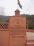
In 1999 the area saw infiltration by Pakistani forces, leading to the Kargil War. Fighting occurred along a 160 km long stretch of ridges overlooking the only road linking Srinagar and Leh.[11] The military outposts on the ridges above the highway were generally around 5,000 metres (16,000 ft) high, with a few as high as 5,485 metres (18,000 ft). After several months of fighting and diplomatic activity, the Pakistani forces were forced to withdraw to their side of the Line of Control by their Prime minister Nawaz Sharif after his visit to the USA.[12]
Geography


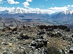
Kargil has an average elevation of 2,676 metres (8,780 feet), and is situated along the banks of the Suru River (Indus). The town of Kargil is located 205 km (127 mi) from Srinagar,[13] facing the Northern Areas across the LOC. Like other areas in the Himalayas, Kargil has a temperate climate. Summers are hot with cool nights, while winters are long and chilly with temperatures often dropping below −20 °C (−4 °F).[14]
Demographics
During the 2011 census, the population of Kargil town was recorded at 16,338. A majority of the population (11,496) is classified as Scheduled Tribes. The literacy rate is 75%.[1]
Religion
Islam is the largest religion in Kargil City, followed by over 77% of people. Hinduism is the second-largest religion with 19.21% adherents. Buddhism and Sikhism form 0.54% and 2.2% of the population respectively.[15]
Media and communications
All India Radio's channel AIR Kargil AM 684 is broadcast from a radio station at Kargil town.[16] Greater Ladakh is the largest Circulated bi-lingual newspaper in whole Ladakh Union Territory that publishes once in a week.
Transportation
Air
Kargil Airport is a non-operational airport located 8 kilometres from the town. The airport is included in UDAN scheme and is proposed to be operational in the near future. The nearest operational airport is the Srinagar International Airport.
Rail
There is no rail-connectivity to Kargil yet. The Srinagar-Kargil-Leh railway line is proposed which will connect Srinagar and Leh via Kargil. The nearest major railway station to Kargil is Jammu Tawi railway station located at a distance of 472 kilometres.
Road
An Indian national highway (NH 1) connecting Srinagar to Leh cuts through Kargil.
Kargil-Skardu Road
A famous all-weather road, the Kargil-Skardu road linked Kargil with Skardu, a city in Gilgit-Baltistan. Since the 1948 Kashmir War, the road has been closed. Whilst the Indian Government has been interested in opening the road as a humanitarian gesture, this has been refused by the Pakistani Government.[17][18][19]
See also
- Kargil War
- Ladakh
- Leh
- Jammu and Kashmir (state)
- Jammu and Kashmir (union territory)
- 1988 Gilgit massacre
References
- ↑ 1.0 1.1 District Census Handbook: Kargil, Directorate of Census Operations, 2011, pp. 22–23
- ↑ "Report of the Commissioner for linguistic minorities: 50th report (July 2012 to June 2013)" (PDF). Commissioner for Linguistic Minorities, Ministry of Minority Affairs, Government of India. p. 49. Archived from the original (PDF) on 8 July 2016. Retrieved 14 January 2015.
- ↑ Ladakh to have headquarters both at Leh and Kargil, Greater Kashmir, 16 February 2019.
- ↑ Osada et al (2000), p. 298.
- ↑ Radhika Gupta, Allegiance and Alienation (2013), p. 49.
- ↑ Grist, Nicola (2008). "Urbanisation in Kargil and its Effects in the Suru Valley". In Martijn van Beek; Fernanda Pirie (eds.). Modern Ladakh: Anthropological Perspectives on Continuity and Change. BRILL. p. 80. ISBN 978-90-474-4334-6.
- ↑ Kalla, Krishan Lal (1997). Kashmir Panorama. Raj Publications. ISBN 978-81-86208-07-6.
- ↑ Ismail Khan (4 September 2005). "A peaceful Kargil". Dawn. Archived from the original on 13 October 2008.
- ↑ Aggarwal, Beyond Lines of Control 2004, p. 35.
- ↑ Cheema, Pervaiz Iqbal (2003). The Armed Forces of Pakistan. Allen & Unwin. ISBN 1-86508-119-1. Pg 4
- ↑ "1999 Kargil Conflict". GlobalSecurity.org. Retrieved 20 May 2009.
- ↑ "War in Kargil – The CCC's summary on the war" (PDF). Archived from the original (PDF) on 27 March 2009. Retrieved 20 May 2009.
- ↑ Profile of Kargil District Archived 18 May 2009 at the Wayback Machine Official website of Kargil District
- ↑ "Climate & Soil conditions". Official website of Kargil District. Archived from the original on 10 April 2009. Retrieved 20 May 2009.
- ↑ 15.0 15.1 "Kargil City Population". Census India. Retrieved 22 September 2020.
- ↑ "How one Ladakhi Woman Kept Kargil's AIR Station Running, Despite Enemy Shelling!". The Better India. 26 July 2020. Retrieved 7 October 2020.
- ↑ "Moving on the Kargil-Skardu road". The Indian Express. 24 April 2007. Retrieved 22 April 2013.
- ↑ "The Kargil-Skardu Route: Implications of its Opening by Zainab Akhter". Ipcs.org. Retrieved 22 April 2013.
- ↑ "Q. 368 Present status of Kargil to Skardu Road | Institute for Defence Studies and Analyses". Idsa.in. 29 March 2012. Retrieved 22 April 2013.
Bibliography
- Aggarwal, Ravina (2004), Beyond Lines of Control: Performance and Politics on the Disputed Borders of Ladakh, India, Duke University Press, ISBN 0-8223-3414-3
- Gupta, Radhika (2013). "Allegiance and Alienation: Border Dynamics in Kargil". In David N. Gellner (ed.). Borderland Lives in Northern South Asia. Duke University Press. pp. 47–71. ISBN 978-0-8223-7730-6.
- Huttenback, Robert A. (1961), "Gulab Singh and the Creation of the Dogra State of Jammu, Kashmir, and Ladakh" (PDF), The Journal of Asian Studies, 20 (4): 477–488, doi:10.2307/2049956, JSTOR 2049956
- Karim, Maj Gen Afsir (2013), Kashmir The Troubled Frontiers, Lancer Publishers LLC, pp. 30–, ISBN 978-1-935501-76-3
- Panikkar, K. M. (1930), Gulab Singh, London: Martin Hopkinson Ltd
Further reading
- Hussain, Javed (21 October 2006). "Kargil: what might have happened". Dawn. Archived from the original on 2 December 2008. Retrieved 20 May 2009.
- Yukiyasu Osada; Gavin Allwright; Atsushi Kanamaru (2000), Mapping the Tibetan World, Tokyo: Kotan Publishing (published 2004), ISBN 0-9701716-0-9
- Paul Beersmans (13 June 1998), Jammu and Kashmir State 1998, Belgian Association for Solidarity with Jammu and Kashmir, archived from the original on 6 October 2007
External links
| History |
| ||||||||||||||||||
|---|---|---|---|---|---|---|---|---|---|---|---|---|---|---|---|---|---|---|---|
| Administration | |||||||||||||||||||
| Geography |
| ||||||||||||||||||
| Human settlements | |||||||||||||||||||
| Culture |
| ||||||||||||||||||
| Tourism and wildlife |
| ||||||||||||||||||
| Transport |
| ||||||||||||||||||
| Infrastructure |
| ||||||||||||||||||
| See also |
| ||||||||||||||||||

