Hanle (village)
Hanle | |
|---|---|
Village | |
 Hanle Village | |
| Coordinates: 32°47′N 79°00′E / 32.79°N 79.00°ECoordinates: 32°47′N 79°00′E / 32.79°N 79.00°E | |
| Country | |
| Union Territory | Ladakh |
| District | Leh |
| Tehsil | Nyoma |
| Population (2011) | |
| • Total | 1,879 |
| Languages | |
| • Official | Hindi and English |
| Time zone | UTC+5:30 (IST) |
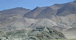
Hanle (also spelt Anle) is a large historic village in the Indian union territory of Ladakh. It is the site of the 17th century Hanle Monastery (gompa) of the Drukpa Kagyu branch of Tibetan Buddhism. Hanle is located in the Hanle River valley on an old branch of the ancient Ladakh–Tibet trade route. More recently, Hanle is the home of Hanle observatory, one of the world's highest sites for astronomical observation.
Geography[edit | edit source]
Hanle is in the valley of the Hanle River, which originates near the Imis La pass on the border with Tibet and joins the Indus river near Nowi and Loma,[1] close to the town of Nyoma. A road running through the Hanle valley from Loma is the quickest way to reach Hanle. Though the road terminates near Hanle, the traditional trade and pilgrimage corridor formerly ran up the Hanle valley to Imis La, crossed into the Indus valley via Charding La near Demchok and Dêmqog, and proceeded to Tashigang in Tibet. This corridor using Tibetan territory is now closed.[2]
Hanle is also connected to Koyul river valley to the east via a winding mountain road that passes through the Photi La pass.[3]
Demographics[edit | edit source]
The valley is home to approximately two thousand people, of whom about 300 people are living in Hanle village.
History[edit | edit source]
Hanle is mentioned by name in the settlement document of the kingdom of Maryul in c. 930 AD, as forming one of its frontiers: "Wam-le (Hanle), to the top of the pass of the Yi-mig rock (Imis pass)". To the west of this frontier were the highlands of Rupshu and, beyond it, Zanskar.[4][5]
Sengge Namgyal (r. 1616–1642) built the prominent Hanle monastery in association with Stag-tsang-ras-pa, the notable Buddhist priest of the Drukpa ("red hat") sect.[6] Sengge Namgyal died here in 1642 after his return from an expedition against the Mongols who had occupied the Tibetan province of Tsang and were threatening Ladakh.[7][8]
Hanle Observatory[edit | edit source]
Hanle is home to the Indian Astronomical Observatory. The location of the village and the observatory are highly sensitive due to the close proximity of the Tibetan / Chinese border. Special permission is needed to visit either by the Indian Government.[citation needed]
India set up the Himalayan Chandra Telescope, a 2m gamma ray telescope at Hanle. The Major Atmospheric Cerenkov Experiment Telescope (MACE), which is under construction in Hanle, will be the world's highest Cerenkov telescope and the second largest Cerenkov telescope in the world.[9] It was originally scheduled to become operational by 2016,[10] but plans were pushed back to begin operations in 2020.[11][12]
Transport[edit | edit source]
Fukche airport is 24 km away, and Ukdungle town is close by.
References[edit | edit source]
Citations[edit | edit source]
- ↑ Ward, A. E. (1896), The Tourist's and Sportsman's guide to Kashmir and Ladak, Thaker, Spink & Co, pp. 113–114 – via archive.org
- ↑ Bhattacharji, Ladakh (2012), Chapter 10, "Hanle: Star gazing in a Corner of Changthang".
- ↑ Bhattacharji, Ladakh (2012), Chapter 9, "Changthang: The High Plateau".
- ↑ Fisher, Rose & Huttenback, Himalayan Battleground (1963), p. 19.
- ↑ Howard & Howard, Historic Ruins in the Gya Valley (2014), p. 83.
- ↑ Rizvi, Ladakh: Crossroads of High Asia (1996), p. 69.
- ↑ Rizvi, Ladakh: Crossroads of High Asia (1996), p. 70.
- ↑ Petech, The Kingdom of Ladakh (1977), pp. 47–48.
- ↑ Sharma, Ravi (29 September 2001). "A stellar acquisition". Frontline. No. Volume 18 - Issue 20. Archived from the original on 14 June 2012.
- ↑ Mallikarjun, Y. (28 June 2014). "Gamma ray telescope to be flagged off to Ladakh". The Hindu.
- ↑ "The Clear Night Sky over India and China's Hostile Border". 19 September 2020.
- ↑ [1]
Sources[edit | edit source]
- Bhattacharji, Romesh (2012), Ladakh: Changing, Yet Unchanged, New Delhi: Rupa Publications – via Academia.edu
- Fisher, Margaret W.; Rose, Leo E.; Huttenback, Robert A. (1963), Himalayan Battleground: Sino-Indian Rivalry in Ladakh, Praeger[dead link]
- Lo Bue, Erberto; Bray, John, eds. (2014), "Introduction", Art and Architecture in Ladakh: Cross-cultural Transmissions in the Himalayas and Karakoram, BRILL, ISBN 978-90-04-27180-7
- Howard, Neil; Howard, Kath (2014), "Historic Ruins in the Gya Valley, Eastern Ladakh, and a Consideration of Their Relationship to the History of Ladakh and Maryul", Ibid, pp. 68–99, ISBN 9789004271807
- Petech, Luciano (1977), The Kingdom of Ladakh, c. 950–1842 A.D. (PDF), Instituto Italiano Per il Medio ed Estremo Oriente – via academia.edu
- Rizvi, Janet (1996), Ladakh: Crossroads of High Asia, Oxford University Press, ISBN 978-0-19-564016-8

