Batalik
Batalik | |
|---|---|
Town | |
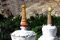
 A village seen through Chortens | |
| Coordinates: 34°39′N 76°20′E / 34.65°N 76.33°ECoordinates: 34°39′N 76°20′E / 34.65°N 76.33°E | |
| Country | |
| Union Territory | Ladakh |
| District | Kargil |
| Tehsil | Kargil |
| Languages | |
| • Official | Hindi, English |
| Time zone | UTC+5:30 (IST) |
| PIN | 194103[1] |
Batalik is a town in Ladakh, India, located on the upper reaches of the Indus river. It has been a focal point in the Kargil War because of its strategic location between Kargil, Leh and Baltistan.[2] In 1999, the Kargil war was fought in this region.[3] Batalik is 56 km from Kargil and is known for its five Brokpa villages: Dah, Hanu, Garkon, Chulichan and Darchik.[4] The Brokpa tribe is believed to be directly descended from the soldiers of Alexander the Great. Most of the valley is made up of nominally Buddhist Brokpas, but a few communities have converted to Shia Islam and intermarried with other Muslim ethnic groups as a result.
Transport[edit]
Road[edit]
Batalik is well-connected by road to other places in Ladakh and India by the Srinagar-Leh Highway or the NH 1.
Rail[edit]
The nearest major railway stations to Batalik are Sopore railway station and Srinagar railway station located at a distance of 271 kilometres and 277 kilometres respectively.
Air[edit]
The nearest airport is at Kargil located at a distance of 60 kilometres but it is currently non-operational. The next nearest major airport is Leh Airport located at a distance of 205 kilometres.
See also[edit]
Manoj Kumar Pandey (The Hero of Batalik)
References[edit]
- ↑ "Batalik (Google Maps)". Google Maps. Retrieved 29 April 2022.
- ↑ "Kargil anniv: 10 years later the war is Drass versus Batalik". Indiatoday.intoday.in. 27 July 2009. Retrieved 30 September 2017.
- ↑ "BATTLE FOR BATALIK". The Tribune. Retrieved 30 September 2017.
- ↑ "Now, go for a vacation to Kargil war battlefield Batalik". Dnaindia.com. 28 May 2010. Retrieved 30 September 2017.


