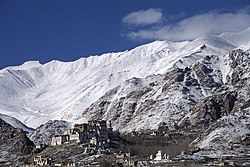
Likir
Likir | |
|---|---|
Village | |
 | |
| Coordinates: 34°17′25″N 77°12′48″E / 34.2903203°N 77.2132106°ECoordinates: 34°17′25″N 77°12′48″E / 34.2903203°N 77.2132106°E | |
| Country | India |
| Union Territory | Ladakh |
| District | Leh |
| Tehsil | Likir[1] |
| Elevation | 3,651 m (11,978 ft) |
| Population (2011) | |
| • Total | 1,058 |
| Languages | |
| • Official | Hindi, English |
| Time zone | UTC+5:30 (IST) |
| 2011 census code | 848 |
Likir is a village and headquarter of eponymous Subdivision in the Leh district of Ladakh, India.[2][3] It is located in the Likir tehsil, in the Ladakh region. Khalatse is a nearby trekking place.[4]
It is famous for the nearby Klu-kkhyil (meaning "water spirits") gompa (Buddhist monastery). The Likir Monastery was first built in the 11th century and was rebuilt in the 18th century, and currently has a 25-foot-tall (7.6 m) gold-covered Buddha statue. It is occupied by monks of the Gelukpa order. It is located 52 km from Leh.
Demographics[edit | edit source]
According to the 2011 census of India, Likir has 218 households. The effective literacy rate (i.e. the literacy rate of population excluding children aged 6 and below) is 72.93%.[5]
| Total | Male | Female | |
|---|---|---|---|
| Population | 1058 | 573 | 485 |
| Children aged below 6 years | 105 | 57 | 48 |
| Scheduled caste | 0 | 0 | 0 |
| Scheduled tribe | 1056 | 572 | 484 |
| Literates | 695 | 432 | 263 |
| Workers (all) | 299 | 211 | 88 |
| Main workers (total) | 255 | 194 | 61 |
| Main workers: Cultivators | 141 | 122 | 19 |
| Main workers: Agricultural labourers | 20 | 16 | 4 |
| Main workers: Household industry workers | 3 | 3 | 0 |
| Main workers: Other | 91 | 53 | 38 |
| Marginal workers (total) | 44 | 17 | 27 |
| Marginal workers: Cultivators | 13 | 2 | 11 |
| Marginal workers: Agricultural labourers | 1 | 0 | 1 |
| Marginal workers: Household industry workers | 1 | 1 | 0 |
| Marginal workers: Others | 29 | 14 | 15 |
| Non-workers | 759 | 362 | 397 |
References[edit | edit source]
- ↑ https://leh.nic.in/about-district/administrative-setup/village/
- ↑ "Blockwise Village Amenity Directory" (PDF). Ladakh Autonomous Hill Development Council. Retrieved 23 July 2015.
- ↑ Leh tehsils.
- ↑ [1]
- ↑ 5.0 5.1 "Leh district census". 2011 Census of India. Directorate of Census Operations. Retrieved 23 July 2015.
