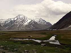
Suru Valley
The Suru Valley is a valley in Kargil District in the Union Territory of Ladakh in India. It is drained by the Suru River, a powerful tributary of the Indus River. The valley's most significant town is Sankoo. Suru Valley is famous for its natural environment.[citation needed] There are many picnic spots in Suru Valley such as Damsna, Parkachik, Sangra, Taisuru, Karpokhar, Khous, Thulus, Stakpa, Umba Namsuru etc. Karpokhar Holy Shrine (Syed Mir Hashim), Khous Holy Shrine & Sanku Holy Shrine (Syed Haider) are famous for prayer in Suru Valley. Horses, Yaks and other variety of animals can be found living in the valley. In winter Suru Valley experiences heavy snowfall and avalanches. The literacy rate of Suru Valley is very low as compared to other parts of Ladakh.
History[edit | edit source]
During the 16th and 17th centuries, the region was composed of small chiefdoms. The most powerful being the Kartse. In the early 18th century, the area became part of the Purig kingdom.[1] Islam was introduced into the area from the 16th century onward from preachers traveling via Baltistan.[2] Purig itself was absorbed by the Namgyal dynasty of Ladakh by the mid-eighteenth century. The Dogras conquered the entire area by 1847 and it proved to be disastrous for the natives. The Dogras were especially harsh to the Muslims (including the nobles) of the area and they attempted to rebel against the Dogras. The current line of control runs near modern Kargil.[1]
People[edit | edit source]
The Suru valley is inhabited by 25,000 by people of Dard and Tibetan descent. In Kargil, the lower Suru Valley (i.e. Sanku, TSG) and the upper Suru Valley (Suru or Panikhar),[3] the majority of the population are followers of Shi'a Islam,[4] having converted from Tibetan Buddhism in the 16th century under the direction of Thi-Namgyal.[citation needed] Beyond Parkachik, the valley is practically uninhabited other than a couple of tiny settlements (Yuldo and Julidok) that consist Rangdum. People here are socially and culturally part of neighbouring Buddhist Zanskar and support the 18th century Rangdum Monastery belonging to the Gelugpa sect of Tibetan Buddhism.[5][6] About 25 km south of Rangdum Monastery, the 4,400 m (14,436 ft) Pensi La (pass) leads into Zanskar[6]
Religion[edit | edit source]
Languages[edit | edit source]
Landscape and agriculture[edit | edit source]
The lower part of the valley, at altitudes below 3,000 metres (9,843 ft), is one of the most agriculturally productive parts of Ladakh with two crops a year being harvested, watered by the run-off from the very heavy winter snowfalls,[9] and even plantations of willow and poplar trees making it a relatively lush and very attractive area, but around Rangdum the landscapes are stark, flat moorlands ringed by arid crags.[10] The spikey white topped mountain peaks of the Nun-Kun massif, topping 7000 m, are visible from several places in the valley.
Tourism[edit | edit source]
Despite considerable potential, tourism activity is very limited in the valley with most visitors rushing through to Padum and Zanskar.[11] There are few facilities for visitors but Jammu & Kashmir Tourism does have basic tourist bungalows in several of the villages.[12] and there's a summer tent-camp in Rangdum. Tangole village is a possible starting point for mountaineering expeditions up Nun Kun.
References[edit | edit source]
- Janet Rizvi. (1996). Ladakh: Crossroads of High Asia. Second Edition. Oxford University Press, Delhi. ISBN 0-19-564546-4.
- Schettler, Margaret & Rolf (1981). Kashmir, Ladakh & Zanskar. Lonely Planet Publications. South Yarra, Victoria, Australia. ISBN 0-908086-21-0.
- Nicola Grist (1998), Local Politics In Suru Valley of Northern India (PhD Thesis)
- ↑ 1.0 1.1 Beek, Martijn van; Pirie, Fernanda (2008). Modern Ladakh: Anthropological Perspectives on Continuity and Change. BRILL. pp. 79–81. ISBN 978-90-474-4334-6.
- ↑ Gellner, David N. (2013). Borderland Lives in Northern South Asia. Duke University Press. p. 50. ISBN 978-0-8223-7730-6.
- ↑ Nicola Grist (1998) p. 19.
- ↑ Rizvi (1996), p. 210.
- ↑ Rizvi (1996), pp. 29, 253.
- ↑ 6.0 6.1 Schettler, Margaret & Rolf (1981), p. 150.
- ↑ "Sanku Population". Census India. Retrieved 28 October 2021.
- ↑ C-16 Population By Mother Tongue – Jammu & Kashmir (Report). Office of the Registrar General & Census Commissioner, India. Retrieved 18 July 2020.
- ↑ Rizvi (1996), pp. 38, 118-119.
- ↑ Rizvi (1996), p. 29.
- ↑ Lonely Planet India, 13th edition, page 296
- ↑ "Jammu & Kashmir Tourism - J&K Tourism".


