

Loyada | |
|---|---|
Village | |
Location in West Bengal, India   Loyada Loyada (India) | |
| Coordinates: 22°26′51″N 87°37′47″E / 22.447611°N 87.629606°E | |
| Country |  India India |
| State | West Bengal |
| District | Paschim Medinipur |
| Population (2011) | |
| • Total | 1,520 |
| Languages* | |
| • Official | Bengali, Santali, English |
| Time zone | UTC+5:30 (IST) |
| PIN | 721136 |
| Telephone/STD code | 03222 |
| Lok Sabha constituency | Ghatal |
| Vidhan Sabha constituency | Debra |
| Website | paschimmedinipur |
Loyada (also spelled Lowada) is a village in the Debra CD block in the Kharagpur subdivision of the Paschim Medinipur district in the state of West Bengal, India.
Geography[edit | edit source]
Lua error in Module:OSM_Location_map at line 1984: attempt to index field 'wikibase' (a nil value).
Location[edit | edit source]
Lowada is located at 22°26′51″N 87°37′47″E / 22.447611°N 87.629606°E.
Area overview[edit | edit source]
Kharagpur subdivision, shown partly in the map alongside, mostly has alluvial soils, except in two CD blocks in the west – Kharagpur I and Keshiary, which mostly have lateritic soils. Around 74% of the total cultivated area is cropped more than once.[1] With a density of population of 787 per km2nearly half of the district's population resides in this subdivision. 14.33% of the population lives in urban areas and 86.67% lives in the rural areas.[2]
Note: The map alongside presents some of the notable locations in the subdivision. All places marked in the map are linked in the larger full screen map.
Demographics[edit | edit source]
According to the 2011 Census of India, Loyada had a total population of 1,520, of which 780 (51%) were males and 740 (49%) were females. There were 211 persons in the age range of 0–6 years. The total number of literate persons in Loyada was 992 (75.78% of the population over 6 years).[3]
.*For language details see Debra (community development block)#Language and religion
Education[edit | edit source]
Lowada High School is a Bengali-medium coeducational institution established in 1952. The school has facilities for teaching from class V to class XII. It has a library with 2,000 books, 10 computers and a playground.[4]
Lowada Balika Vidyalaya is a Bengali-medium girls only institution established in 1971. The school has facilities for teaching from class V to class XII. It has a library with 534 books and 4 computers.[5]
Culture[edit | edit source]
David J. McCutchion mentions:[6]
- The Gopinath temple of the Mukherjee family as standard West Bengal type pancha-ratna, brick temple with terracotta, built in 1805
- The Sridhara temple of the Mukherjee family as a flat roofed or chandni type, with terracotta and stucco work
- The Radha-Govinda temple as a smooth rekha deul with a porch having low-founded pyramidal roof, built in 1860, having rich terracotta.
Laoada picture gallery[edit | edit source]
-
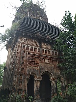 Radhagobinda Jiu temple: Shikhar deul with porch in front
 -
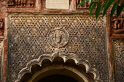 Terracotta decoration in Radhagobindajiu temple
 -
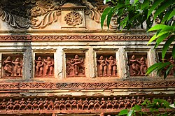 Terracotta decoration in Radhagobindajiu temple


References[edit | edit source]
- ↑ "District Human Development Report Paschim Medinipur, 2011". page 27-28. Department of Planning and Statistics, Government of West Bengal. Retrieved 10 September 2020.
- ↑ "District Statistical Handbook Paschim Medinipur, 2013". Table 2.2, 2.4 (a). Department of Planning and Statistics. Retrieved 10 September 2020.
- ↑ "CD block Wise Primary Census Abstract Data(PCA)". West Bengal – District-wise CD blocks. Registrar General and Census, India. Retrieved 3 September 2020.
- ↑ "Lowada High School U Pry". Schools.org. Retrieved 4 September 2020.
- ↑ "Lowada Balika V. U. Pry". Schools.org. Retrieved 1 February 2020.
- ↑ McCutchion, David J., Late Mediaeval Temples of Bengal, first published 1972, reprinted 2017, page 46, 63, 72. The Asiatic Society, Kolkata, ISBN 978-93-81574-65-2


