Achkoda | |
|---|---|
Village | |
Location in West Bengal, India  Achkoda Achkoda (India) | |
| Coordinates: 23°38′19″N 86°38′16″E / 23.6385°N 86.6378°E | |
| Country | |
| State | West Bengal |
| District | Purulia |
| Population (2011) | |
| • Total | 1,178 |
| Languages | |
| • Official | Bengali, English |
| Time zone | UTC+5:30 (IST) |
| PIN | 723145 |
| Telephone/STD code | 03251 |
| Lok Sabha constituency | Bankura |
| Vidhan Sabha constituency | Raghunathpur |
| Website | purulia |
Achkoda (sometimes spelled Anchkoda) is a village in the Neturia CD block in the Raghunathpur subdivision of the Purulia district in the state of West Bengal, India.
Geography[edit | edit source]
Lua error in Module:OSM_Location_map at line 1984: attempt to index field 'wikibase' (a nil value).
Location[edit | edit source]
Achkoda is located at 23°38′19″N 86°38′16″E / 23.6385°N 86.6378°E.
Area overview[edit | edit source]
Purulia district forms the lowest step of the Chota Nagpur Plateau. The general scenario is undulating land with scattered hills.[1] Raghunathpur subdivision occupies the northern part of the district. 83.80% of the population of the subdivision lives in rural areas. However, there are pockets of urbanization and 16.20% of the population lives in urban areas. There are 14 census towns in the subdivision.[2] It is presented in the map given alongside. There is a coal mining area around Parbelia[3] and two thermal power plants are there – the 500 MW Santaldih Thermal Power Station[4] and the 1200 MW Raghunathpur Thermal Power Station. The subdivision has a rich heritage of old temples, some of them belonging to the 11th century or earlier. The Banda Deul is a monument of national importance.[5][6] The comparatively more recent in historical terms, Panchkot Raj has interesting and intriguing remains in the area.[7][8]
Note: The map alongside presents some of the notable locations in the subdivision. All places marked in the map are linked in the larger full screen map.
Demographics[edit | edit source]
According to the 2011 Census of India, Achkoda had a total population of 1,178, of which 596 (51%) were males and 582 (49%) were females. There were 582 persons in the age range of 0-6 years. The total number of literate persons in Achkoda was 640 (62.75% of the population over 6 years).[9]
Culture[edit | edit source]
Achkoda, like Cheliyama, showcases aatchala-style temples with terracotta work on the walls. However, while there has been restoration at Cheliyama, Achkoda remains untouched. Achkoda “seems to be at least five centuries old. Its panels are smaller in size (than those at Cheliyama) and some of them depict tribal life.”[10]
Achkoda picture gallery[edit | edit source]
-
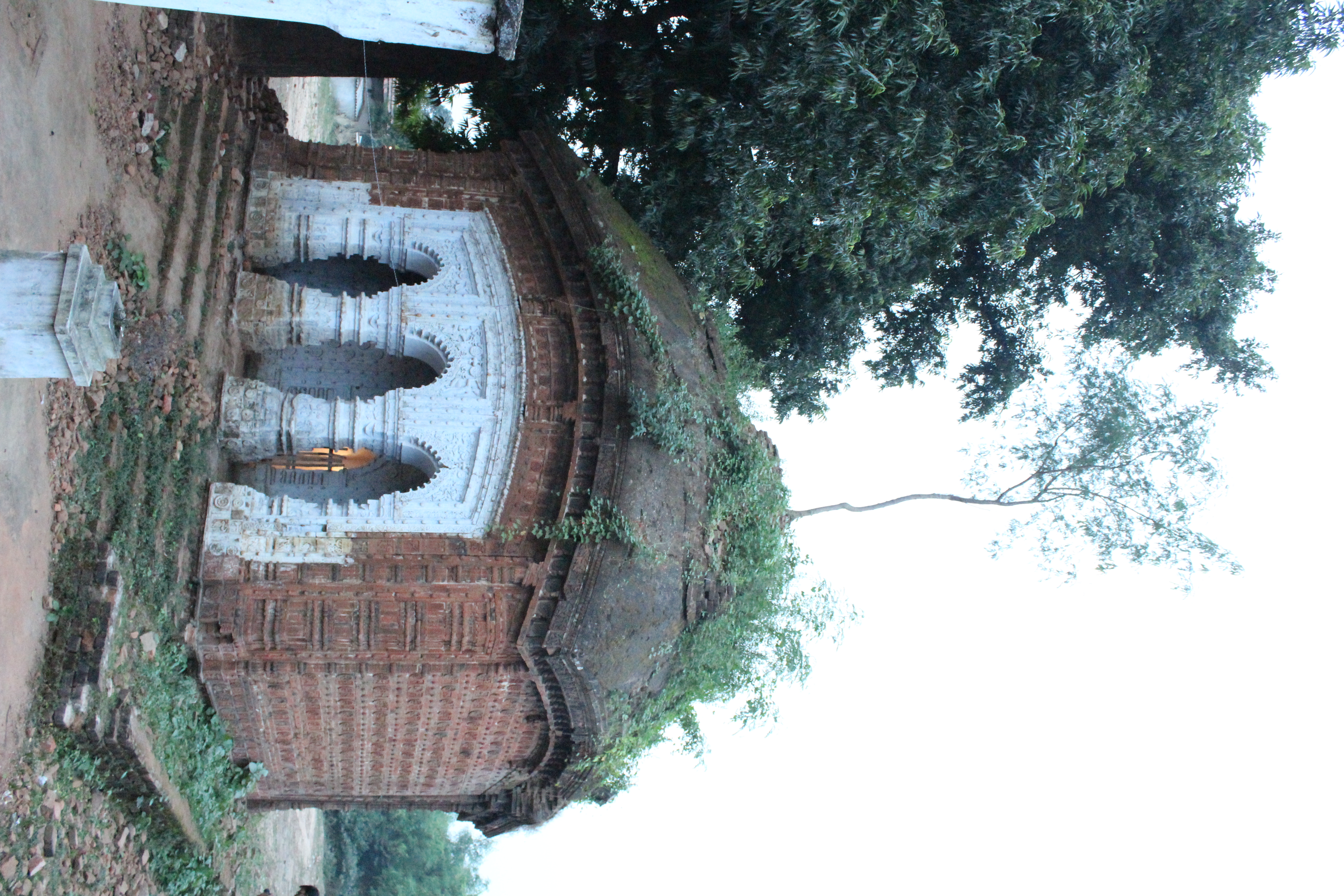 Charchala temple
 -
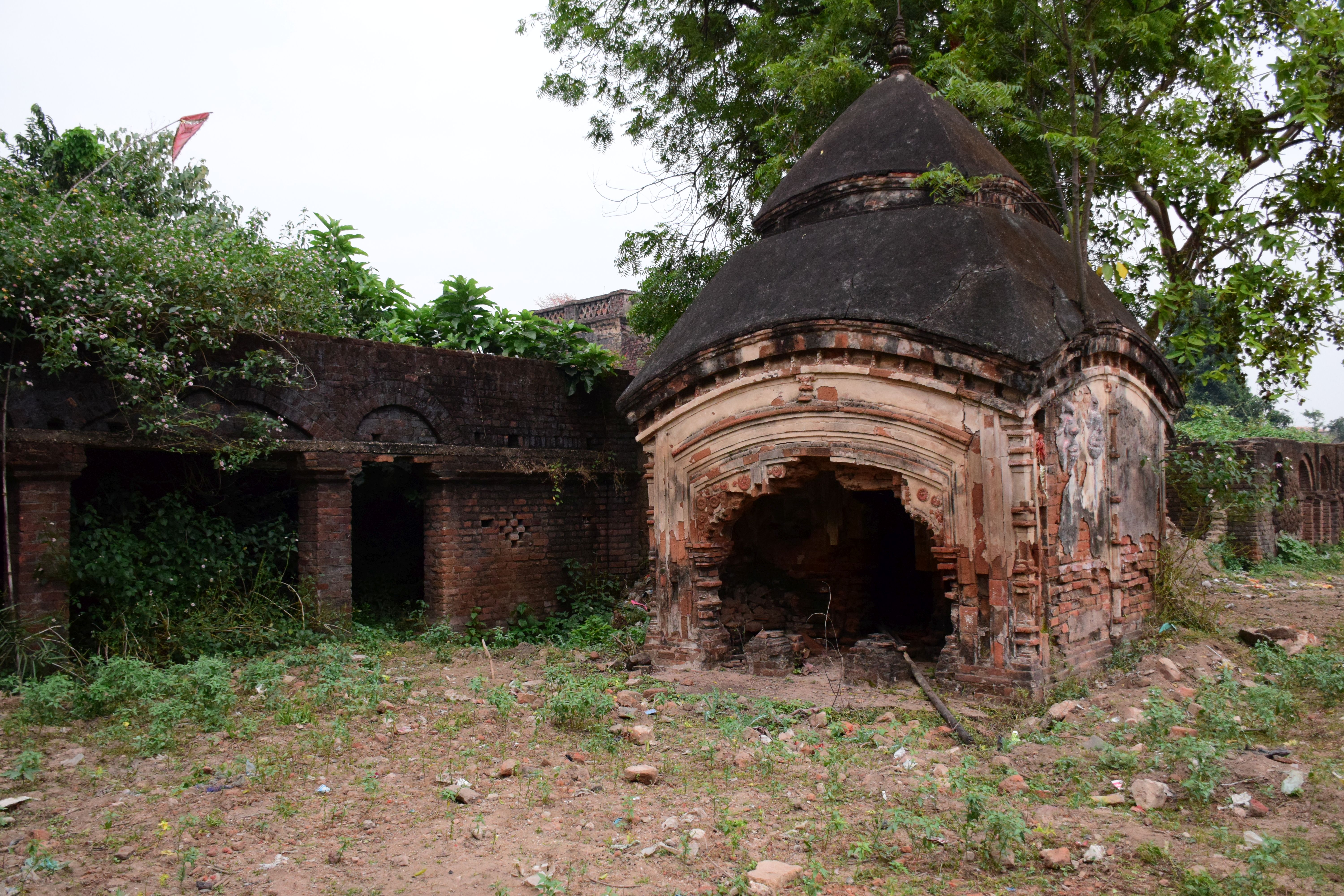 Ruined atchala temple
 -
 Trracotta on the back wall


Terracotta carvings[edit | edit source]


References[edit | edit source]
- ↑ Houlton, Sir John, Bihar, the Heart of India, 1949, p. 170, Orient Longmans Ltd.
- ↑ "District Statistical Handbook 2014 Purulia". Tables 2.1, 2.2. Department of Planning and Statistics, Government of West Bengal. Archived from the original on 21 January 2019. Retrieved 12 January 2020.
- ↑ "Area wise Closed User Group (CUG) Telephone Numbers" (PDF). Sodepur Area. Eastern Coalfields Limited. Retrieved 11 August 2018.
- ↑ "Santaldih Thermal Power Station - WBPDCL". WBPDCL. Archived from the original on 2010-01-11. Retrieved 2011-08-24.
- ↑ "Old temple at Banda (locally known as deul)". ASI, Kolkata Circle. Retrieved 23 January 2020.
- ↑ "List of Ancient Monuments and Archaeological Sites and Remains of West Bengal - Archaeological Survey of India". Item no. 134. ASI. Retrieved 25 January 2020.
- ↑ "Capital in shambles: Garh Panchakot, Purulia". Heritage in Peril. Retrieved 1 December 2016.
- ↑ "Historical ruins". Trek Earth. Retrieved 1 December 2016.
- ↑ "C.D. Block Wise Primary Census Abstract Data(PCA)". West Bengal – District-wise CD Blocks. Registrar General and Census Commissioner, India. Retrieved 28 January 2020.
- ↑ Gupta, Amitabha. "Rediscover Purulia's Timeless Heritage". Outlook traveller, 22 August 2018. Retrieved 28 January 2020.
External links[edit | edit source]
Cities, towns and locations in Purulia district, West Bengal | |||||||||
|---|---|---|---|---|---|---|---|---|---|
| Cities, municipal and census towns |
| ||||||||
| Locations other than cities and towns |
| ||||||||
| Related topics | |||||||||