




Ajay Kumar (talk | contribs) Created a new article |
ShondaLemos (talk | contribs) minor edit |
||
| Line 1: | Line 1: | ||
{{Short description |Human settlement with high population density and infrastructure of built environment}} | {{Short description|Human settlement with high population density and infrastructure of built environment}} | ||
{{Redirect|Built up area|the Highway Code|Built-up area ( | {{Redirect|Built up area|the Highway Code|Built-up area (traffic management)}} | ||
{{Redirect|Urban agglomeration|city clusters|Megalopolis}} | {{Redirect|Urban agglomeration|city clusters|Megalopolis}} | ||
[[File: | {{Redirect|Urbanite|the type of recycled concrete|Concrete recycling}} | ||
[[File: | |||
[[File:Seoul (175734251) (cropped).jpg|thumb|Skyline of [[Seoul]] at night]] | |||
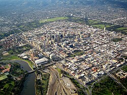
[[File:Adelaide DougBarber.jpg|thumb|Aerial view of [[Greater Adelaide]], the [[Adelaide Park Lands|parklands]] serve as a barrier between the inner [[central business district|CBD]] and encompassing urban area]] | |||
[[File:Northeast megalopolis at night.jpg|thumb|A [[satellite]] view of the U.S. [[Northeast megalopolis]] at night, the world's most [[GDP|economically productive]] megalopolis<ref>{{cite news |title = The Real Powerhouses That Drive the World's Economy |last = Florida |newspaper = Bloomberg.com |access-date=December 21, 2024|url = https://www.citylab.com/life/2019/02/global-megaregions-economic-powerhouse-megalopolis/583729/ }}</ref> with over 50 million residents, centered on [[New York City]]]] | |||
[[File:ISS-67_City_lights_of_São_Paulo,_Brazil.jpg|thumb|[[Greater São Paulo]] at night, as seen from the [[International Space Station]]]] | [[File:ISS-67_City_lights_of_São_Paulo,_Brazil.jpg|thumb|[[Greater São Paulo]] at night, as seen from the [[International Space Station]]]] | ||
[[File:Aglomeracja warszawska wg Swianiewicza.png|thumb|[[Warsaw metropolitan area]]]] | [[File:Aglomeracja warszawska wg Swianiewicza.png|thumb|[[Warsaw metropolitan area]]]] | ||
An '''urban area'''{{efn|Also known as a '''built-up area''' or '''urban agglomeration'''.}} is a [[human settlement]] with a high [[population density]] and an [[infrastructure]] of [[built environment]]. Urban areas originate through [[urbanization]], and researchers categorize them as cities, towns, [[conurbation]]s or [[suburbs]]. In [[urbanism]], the term "urban area" contrasts to [[rural area]]s such as [[village]]s and [[hamlet (place)|hamlets]]; in [[urban sociology]] or [[urban anthropology]], it often contrasts with [[natural environment]]. | |||
An '''urban area''' | |||
Urban areas originate through [[urbanization]], and researchers categorize them as | |||
The development of earlier predecessors of modern urban areas during the [[urban revolution]] of the [[4th millennium BCE]]<ref> | The development of earlier predecessors of modern urban areas during the [[urban revolution]] of the [[4th millennium BCE]]<ref> | ||
| Line 28: | Line 27: | ||
|quote = [...] the Bronze Age, starting between 3500 and 3000 BC [...]. During this [...] period the first urban civilizations were firmly established. | |quote = [...] the Bronze Age, starting between 3500 and 3000 BC [...]. During this [...] period the first urban civilizations were firmly established. | ||
}} | }} | ||
</ref> | </ref> led to the formation of human [[civilization]] and ultimately to modern [[urban planning]], which along with other human activities such as [[exploitation of natural resources]] has led to a [[human impact on the environment]]. | ||
led to the formation of human [[civilization]] and ultimately to modern [[urban planning]], which along with other human activities such as [[exploitation of natural resources]] has led to a [[human impact on the environment]]. | |||
==Recent historical growth== | |||
[[File:Global land use for food production, OWID statistic.png|thumb|upright=1.3|Earth's land use in 2019, built-up area being estimated as 1.5 million square kilometers]] | |||
In 1950, 764 million people (or about 30 percent of the world's 2.5 billion people) lived in urban areas. In 2009, the number of people living in urban areas (3.42 billion) surpassed the number living in rural areas (3.41 billion), and since then the world has become more urban than rural.<ref>{{cite web |title=United Nations Population Division – Department of Economic and Social Affairs |url=https://www.un.org/en/development/desa/population/publications/urbanization/urban-rural.shtml |access-date=2026-01-07 |website=www.un.org}}</ref> By 2014, it was 3.9 billion (or about 53 percent of the world's 7.3 billion people) that lived in urban areas. The change was driven by a combination of increased total population and increased percent of population living in urban areas.<ref name="UrbanPopulation">{{cite news|title=City population to reach 6.4bn by 2050|url=http://www.heraldglobe.com/index.php/sid/223727231/scat/2411cd3571b4f088/ht/City-population-to-reach-64bn-by-2050|access-date=11 July 2014|work=Herald Globe|archive-url=https://web.archive.org/web/20140714211145/http://www.heraldglobe.com/index.php/sid/223727231/scat/2411cd3571b4f088/ht/City-population-to-reach-64bn-by-2050|archive-date=2014-07-14|url-status=dead}}</ref> This was the first time that the majority of the world's population lived in a city.<ref>{{cite web |url=https://www.who.int/gho/urban_health/situation_trends/urban_population_growth_text/en/ |archive-url=https://web.archive.org/web/20120308235946/http://www.who.int/gho/urban_health/situation_trends/urban_population_growth_text/en/ |url-status=dead |archive-date=March 8, 2012 |title= Urban population growth |publisher= World Health Organization}}</ref> By that time a high estimate calculated up to 3.5 million square kilometers of land were urban, estimates ranging from 1% of global land area.<ref name="c171">{{cite web | title=How Much of the World is Covered by Cities? | website=Newgeography.com | date=July 23, 2010 | url=https://www.newgeography.com/content/001689-how-much-world-covered-cities |first1=Wendell |last1=Cox | access-date=October 30, 2024}}</ref><ref name="r019">{{cite journal | last=Ritchie | first=Hannah | last2=Roser | first2=Max | title=Land Use | journal=Our World in Data | date=May 2024 |orig-date=September 2019 | url=https://ourworldindata.org/land-use#half-of-the-world-s-habitable-land-is-used-for-agriculture | access-date=October 30, 2024 | page=}}</ref> | |||
In 2014 there were 7.3 billion people living on the planet,<ref name="WorldPopulation">{{cite news |title= Current world population |url= http://www.geohive.com/earth/population_now.aspx |access-date= 11 July 2014 |publisher= UniGeoHive |url-status= dead |archive-url= https://web.archive.org/web/20140702055710/http://www.geohive.com/earth/population_now.aspx |archive-date= 2 July 2014 }}</ref> of which the global urban population comprised 3.9 billion. The Population Division of the [[United Nations Department of Economic and Social Affairs]] at that time predicted the urban population would occupy 68% of the world population by 2050, with 90% of that growth coming from [[Africa]] and [[Asia]].<ref>{{Cite web |title=Climate Change 2022: Mitigation of Climate Change |url=https://www.ipcc.ch/report/ar6/wg3/ |access-date=2022-04-04 |website=Intergovernmental Panel on Climate Change |language=en}}</ref> | |||
==Urbanization== | ==Urbanization== | ||
{{ | {{Main|Urbanization}} | ||
[[File:Urban land area (km²), OWID.svg|thumb|Urban land area (km<sup>2</sup>), 2010<ref>{{cite web |title=Urban land area (km²) |url=https://ourworldindata.org/grapher/urban-land-area |website=Our World in Data |access-date=6 March 2020}}</ref>]] | [[File:Urban land area (km²), OWID.svg|thumb|Urban land area (km<sup>2</sup>), 2010<ref>{{cite web |title=Urban land area (km²) |url=https://ourworldindata.org/grapher/urban-land-area |website=Our World in Data |access-date=6 March 2020}}</ref>]] | ||
[[File: | [[File:Cities with 1M People in 2025.png|thumb|Urban areas with at least one million inhabitants in 2025]] | ||
Unlike an urban area, a [[metropolitan area]] includes not only the urban area, but also [[satellite city|satellite cities]] | Urban areas are created and further developed by the process of urbanization. They are measured for various purposes, including analyzing [[population density]] and [[urban sprawl]]. Urban areas are generally found in the [[United States]], [[Canada]], [[Brazil]], [[Mexico]], [[Argentina]], [[Chile]], [[Japan]], [[Australia]], and many other countries where the urbanization rate is high. | ||
Unlike an urban area, a [[metropolitan area]] includes not only the urban area, but also intervening rural land and [[satellite city|satellite cities]] that are socio-economically connected to the urban area. The urban area serves as the core of a metropolitan area, typically by [[employment]] ties through [[commuting]], with the urban area being the [[primary labor market]].<ref>{{cite web|url= https://www.census.gov/programs-surveys/metro-micro/about/glossary.html|title=US Census Glossary|publisher= US census Bureau|access-date=October 9, 2025}}</ref> | |||
The concept of an "urban area" as used in economic statistics should not be confused with the concept of the "urban area" used in road safety statistics. This term was first created by Geographer Brian Manning. The last concept is also known as "[[Built-up area (Highway Code)|built-up area in road safety]]". According to the definition by the [[Office for National Statistics]], "Built-up areas are defined as land which is 'irreversibly urban in character', meaning that they are characteristic of a town or city. They include areas of built-up land with a minimum of {{convert|20|ha|sqm acre}}. Any areas [separated by] less than 200 metres [of non-urban space] are linked to become a single built-up area.<ref>{{cite web| url=https://www.ons.gov.uk/peoplepopulationandcommunity/housing/articles/characteristicsofbuiltupareas/2013-06-28|title=2011 Census: Characteristics of Built-Up Areas (4. Introduction)|publisher=Office for National Statistics|date=28 June 2013|access-date=20 October 2019}}</ref> | The concept of an "urban area" as used in economic statistics should not be confused with the concept of the "urban area" used in road safety statistics. This term was first created by Geographer Brian Manning. The last concept is also known as "[[Built-up area (Highway Code)|built-up area in road safety]]". According to the definition by the [[Office for National Statistics]], "Built-up areas are defined as land which is 'irreversibly urban in character', meaning that they are characteristic of a town or city. They include areas of built-up land with a minimum of {{convert|20|ha|sqm acre}}. Any areas [separated by] less than 200 metres [of non-urban space] are linked to become a single built-up area.<ref>{{cite web| url=https://www.ons.gov.uk/peoplepopulationandcommunity/housing/articles/characteristicsofbuiltupareas/2013-06-28|title=2011 Census: Characteristics of Built-Up Areas (4. Introduction)|publisher=Office for National Statistics|date=28 June 2013|access-date=20 October 2019}}</ref> | ||
[[Argentina]] and [[Japan]] are countries where the urbanization rate is over 90% while Australia, Brazil, Canada, [[Mexico]] and the United States are countries where the urbanization rate is between 80% and 90%. | [[Argentina]] and [[Japan]] are countries where the urbanization rate is over 90% while [[Australia]], [[Brazil]], [[Canada]], [[Chile]], [[Mexico]], and the [[United States]] are countries where the urbanization rate is between 80% and 90%, although within the [[U.S. state]] of [[New Jersey]], the urbanization rate is 100%.<ref>{{Cite journal |last=Ritchie |first=Hannah |last2=Samborska |first2=Veronika |last3=Roser |first3=Max |date=2024-02-23 |title=Urbanization |url=https://ourworldindata.org/urbanization#:~:text=Using%20these%20definitions,%20it%20reports,shown%20in%20the%20chart%20below. |journal=Our World in Data |access-date=2026-01-07}}</ref> | ||
== Largest urban areas == | ==Largest urban areas== | ||
{{See also|List of largest cities|List of largest urban areas by country|List of largest urban areas by continent}} | |||
There are two measures of the degree of urbanization of a population. The first, urban population, describes the percentage of the total population living in urban areas, as defined by the country. The second measure, rate of urbanization, describes the projected average rate of change of the size of the urban population over the given period of time. According to [[Urbanization by sovereign state]] article, the world as a whole is 56.2% urbanized, with roughly one-quarter of the countries reported as greater than 80% urbanized. Data is taken from the U.S. Central Intelligence Agency World Factbook estimates from 2020.<ref>{{cite web|url=https://www.cia.gov/the-world-factbook/field/urbanization|archive-url=https://web.archive.org/web/20210108184227/https://www.cia.gov/the-world-factbook/field/urbanization|url-status=dead|archive-date=January 8, 2021|title=World Factbook Urbanization|work=Central Intelligence Agency|access-date=26 August 2018}}</ref> | |||
According to | |||
According to [[Demographia]], these are the urban areas in the world with a population exceeding 5,000,000 (as of 2025):<ref>{{cite web |last=Cox |first=Wendell |date=August 2025 |title=Demographia World Urban Areas – 20th Annual Edition |url=https://blogs.chapman.edu/wp-content/uploads/sites/56/2025/06/Demographia-World-Urban-2025.pdf |access-date=September 14, 2025 |publisher=[[Demographia]]}}</ref> | |||
{| class="wikitable sortable mw-collapsible" | |||
|+ | |||
! | |||
!Urban Area | |||
!Country/ Region | |||
!Population | |||
|- | |||
|1 | |||
|[[Guangzhou]]-[[Shenzhen]] | |||
|[[China]] | |||
|69,562,000 | |||
|- | |||
|2 | |||
|[[Shanghai]]-[[Changzhou]] | |||
|China | |||
|45,115,000 | |||
|- | |||
|3 | |||
|[[Tokyo]]-[[Yokohama]] | |||
|[[Japan]] | |||
|37,325,000 | |||
|- | |||
|4 | |||
|[[Jakarta]] | |||
|[[Indonesia]] | |||
|36,877,000 | |||
|- | |||
|5 | |||
|[[Delhi]] | |||
|[[India]] | |||
|33,224,000 | |||
|- | |||
|6 | |||
|[[Mumbai]] | |||
|India | |||
|26,237,000 | |||
|- | |||
|7 | |||
|[[Manila]] | |||
|[[Philippines]] | |||
|25,521,000 | |||
|- | |||
|8 | |||
|[[Dhaka]] | |||
|[[Bangladesh]] | |||
|25,305,000 | |||
|- | |||
|9 | |||
|[[Seoul]]-[[Incheon]] | |||
|[[South Korea]] | |||
|23,825,000 | |||
|- | |||
|10 | |||
|[[Mexico City]] | |||
|[[Mexico]] | |||
|23,146,802 | |||
|- | |||
|11 | |||
|[[Cairo]] | |||
|[[Egypt]] | |||
|22,684,000 | |||
|- | |||
|12 | |||
|[[Beijing]] | |||
|China | |||
|22,363,000 | |||
|- | |||
|13 | |||
|[[São Paulo]] | |||
|[[Brazil]] | |||
|21,747,000 | |||
|- | |||
|14 | |||
|[[Karachi]] | |||
|[[Pakistan]] | |||
|21,258,000 | |||
|- | |||
|15 | |||
|[[Kolkata]] | |||
|India | |||
|20,327,000 | |||
|- | |||
|16 | |||
|[[Bangkok]] | |||
|[[Thailand]] | |||
|20,284,000 | |||
|- | |||
|17 | |||
|[[New York City|New York]] | |||
|[[United States]] | |||
|19,426,449 | |||
|- | |||
|18 | |||
|[[Moscow]] | |||
|[[Russia]] | |||
|19,100,000 | |||
|- | |||
|19 | |||
|[[Bangalore]] | |||
|India | |||
|16,216,000 | |||
|- | |||
|20 | |||
|[[Ho Chi Minh City]] | |||
|[[Vietnam]] | |||
|16,024,000 | |||
|- | |||
|21 | |||
|[[Buenos Aires]] | |||
|[[Argentina]] | |||
|15,933,000 | |||
|- | |||
|22 | |||
|[[Lagos]] | |||
|[[Nigeria]] | |||
|15,283,000 | |||
|- | |||
|23 | |||
|[[Johannesburg]]-[[Pretoria]] | |||
|[[South Africa]] | |||
|15,026,000 | |||
|- | |||
|24 | |||
|[[Osaka]]-[[Kobe]]-[[Kyoto]] | |||
|Japan | |||
|14,998,000 | |||
|- | |||
|25 | |||
|[[Istanbul]] | |||
|[[Turkey]] | |||
|14,749,000 | |||
|- | |||
|26 | |||
|[[Lahore]] | |||
|Pakistan | |||
|14,256,000 | |||
|- | |||
|27 | |||
|[[Tehran]] | |||
|[[Iran]] | |||
|14,137,000 | |||
|- | |||
|28 | |||
|[[Kinshasa]] | |||
|[[Democratic Republic of the Congo]] | |||
|13,060,000 | |||
|- | |||
|29 | |||
|[[Rio de Janeiro]] | |||
|Brazil | |||
|12,546,000 | |||
|- | |||
|30 | |||
|[[Hangzhou]]-[[Shaoxing]] | |||
|China | |||
|12,422,000 | |||
|- | |||
|31 | |||
|[[Los Angeles]] | |||
|United States | |||
|12,237,376 | |||
|- | |||
|32 | |||
|[[Shantou]]-[[Jieyang]] | |||
|China | |||
|12,187,000 | |||
|- | |||
|33 | |||
|[[Tianjin]] | |||
|China | |||
|12,095,000 | |||
|- | |||
|34 | |||
|[[Chennai]] | |||
|India | |||
|11,950,000 | |||
|- | |||
|35 | |||
|[[Luanda]] | |||
|[[Angola]] | |||
|11,892,000 | |||
|- | |||
|36 | |||
|[[Chongqing]] | |||
|China | |||
|11,524,000 | |||
|- | |||
|37 | |||
|[[London]] | |||
|[[United Kingdom]] | |||
|11,360,000 | |||
|- | |||
|38 | |||
|[[Paris]] | |||
|[[France]] | |||
|11,282,000 | |||
|- | |||
|39 | |||
|[[Lima]] | |||
|[[Peru]] | |||
|10,914,000 | |||
|- | |||
|40 | |||
|[[Bogotá|Bogota]] | |||
|[[Colombia]] | |||
|10,734,000 | |||
|- | |||
|41 | |||
|[[Hyderabad]] | |||
|India | |||
|10,101,000 | |||
|- | |||
|42 | |||
|[[Wuhan]] | |||
|China | |||
|10,041,000 | |||
|- | |||
|43 | |||
|[[Kuala Lumpur]] | |||
|[[Malaysia]] | |||
|9,899,000 | |||
|- | |||
|44 | |||
|[[Taipei]] | |||
|[[Taiwan]] | |||
|9,866,000 | |||
|- | |||
|45 | |||
|[[Nagoya]] | |||
|Japan | |||
|9,617,000 | |||
|- | |||
|46 | |||
|[[Nanjing]] | |||
|China | |||
|8,929,000 | |||
|- | |||
|47 | |||
|[[Dar es Salaam]] | |||
|[[Tanzania]] | |||
|8,877,000 | |||
|- | |||
|48 | |||
|[[Chicago]] | |||
|United States | |||
|8,790,000 | |||
|- | |||
|49 | |||
|[[Riyadh]] | |||
|[[Saudi Arabia]] | |||
|8,589,000 | |||
|- | |||
|50 | |||
|[[Xi'an]] | |||
|China | |||
|8,313,000 | |||
|- | |||
|51 | |||
|[[Chengdu]] | |||
|China | |||
|8,040,000 | |||
|- | |||
|52 | |||
|[[Ahmedabad|Ahmedabad]] | |||
|India | |||
|7,961,000 | |||
|- | |||
|53 | |||
|[[Addis Ababa]] | |||
|[[Ethiopia]] | |||
|7,922,000 | |||
|- | |||
|54 | |||
|[[Shenyang]]-[[Fushun]] | |||
|China | |||
|7,768,000 | |||
|- | |||
|55 | |||
|[[Onitsha]] | |||
|Nigeria | |||
|7,756,000 | |||
|- | |||
|56 | |||
|[[Khartoum]] | |||
|[[Sudan]] | |||
|7,677,000 | |||
|- | |||
|57 | |||
|[[Washington, D.C.|Washington]]-[[Baltimore]] | |||
|United States | |||
|7,636,000 | |||
|- | |||
|58 | |||
|[[Bandung]] | |||
|Indonesia | |||
|7,490,000 | |||
|- | |||
|59 | |||
|[[Boston]]-[[Providence, Rhode Island|Providence]] | |||
|United States | |||
|7,375,000 | |||
|- | |||
|60 | |||
|[[Nairobi]] | |||
|[[Kenya]] | |||
|7,264,000 | |||
|- | |||
|61 | |||
|[[Santiago]] | |||
|[[Chile]] | |||
|7,192,000 | |||
|- | |||
|62 | |||
|[[Baghdad]] | |||
|[[Iraq]] | |||
|7,160,000 | |||
|- | |||
|63 | |||
|[[Hong Kong]] | |||
|[[Hong Kong|Hong Kong SAR]] | |||
|7,117,000 | |||
|- | |||
|64 | |||
|[[Dallas]]-[[Fort Worth, Texas|Fort Worth]] | |||
|United States | |||
|6,980,000 | |||
|- | |||
|65 | |||
|[[Madrid]] | |||
|[[Spain]] | |||
|6,966,000 | |||
|- | |||
|66 | |||
|[[Pune]] | |||
|India | |||
|6,944,000 | |||
|- | |||
|67 | |||
|[[Essen]]-[[Düsseldorf]] | |||
|[[Germany]] | |||
|6,874,000 | |||
|- | |||
|68 | |||
|[[Zhengzhou]] | |||
|China | |||
|6,860,000 | |||
|- | |||
|69 | |||
|[[Surabaya]] | |||
|Indonesia | |||
|6,820,000 | |||
|- | |||
|69 | |||
|[[Yangon]] | |||
|[[Myanmar]] | |||
|6,820,000 | |||
|- | |||
|71 | |||
|[[Houston]] | |||
|United States | |||
|6,804,000 | |||
|- | |||
|72 | |||
|[[Amman]] | |||
|[[Jordan]] | |||
|6,694,000 | |||
|- | |||
|73 | |||
|[[Quanzhou]] | |||
|China | |||
|6,487,000 | |||
|- | |||
|74 | |||
|[[Abidjan]] | |||
|[[Ivory Coast]] | |||
|6,461,000 | |||
|- | |||
|75 | |||
|[[Toronto]] | |||
|[[Canada]] | |||
|6,400,000 | |||
|- | |||
|76 | |||
|[[San Francisco]] | |||
|United States | |||
|6,376,000 | |||
|- | |||
|77 | |||
|[[Accra]] | |||
|[[Ghana]] | |||
|5,785,000 | |||
|- | |||
|78 | |||
|[[Surat]] | |||
|India | |||
|6,601,000 | |||
|- | |||
|79 | |||
|[[Xiamen]]-[[Zhangzhou]] | |||
|China | |||
|6,237,000 | |||
|- | |||
|80 | |||
|[[Miami]] | |||
|United States | |||
|6,129,000 | |||
|- | |||
|81 | |||
|[[Singapore]] | |||
|[[Singapore]] | |||
|6,056,000 | |||
|- | |||
|82 | |||
|[[Kabul]] | |||
|[[Afghanistan]] | |||
|6,009,000 | |||
|- | |||
|83 | |||
|[[Alexandria]] | |||
|Egypt | |||
|5,916,000 | |||
|- | |||
|84 | |||
|[[Hefei]] | |||
|China | |||
|5,875,000 | |||
|- | |||
|85 | |||
|[[Saint Petersburg|St. Petersburg]] | |||
|Russia | |||
|5,869,000 | |||
|- | |||
|86 | |||
|[[Qingdao]] | |||
|China | |||
|5,806,000 | |||
|- | |||
|87 | |||
|[[Hanoi]] | |||
|Vietnam | |||
|5,700,000 | |||
|- | |||
|88 | |||
|[[Philadelphia]] | |||
|United States | |||
|5,697,000 | |||
|- | |||
|89 | |||
|[[Faisalabad]] | |||
|Pakistan | |||
|5,650,000 | |||
|- | |||
|90 | |||
|[[Ankara]] | |||
|Turkey | |||
|5,638,000 | |||
|- | |||
|91 | |||
|[[Milan]] | |||
|[[Italy]] | |||
|5,631,000 | |||
|- | |||
|92 | |||
|[[Atlanta]] | |||
|United States | |||
|5,495,000 | |||
|- | |||
|93 | |||
|[[Barcelona]] | |||
|Spain | |||
|5,489,000 | |||
|- | |||
|94 | |||
|[[Jeddah|Jiddah]] | |||
|Saudi Arabia | |||
|5,482,000 | |||
|- | |||
|95 | |||
|[[Taiyuan]] | |||
|China | |||
|5,371,000 | |||
|- | |||
|96 | |||
|[[Belo Horizonte]] | |||
|Brazil | |||
|5,368,000 | |||
|- | |||
|97 | |||
|[[Mashhad]] | |||
|Iran | |||
|5,321,000 | |||
|- | |||
|98 | |||
|[[Rawalpindi]]-[[Islamabad]] | |||
|Pakistan | |||
|5,203,000 | |||
|- | |||
|99 | |||
|[[Kumasi]] | |||
|Ghana | |||
|5,192,000 | |||
|- | |||
|100 | |||
|[[Melbourne]] | |||
|[[Australia]] | |||
|5,185,000 | |||
|- | |||
|101 | |||
|[[Dubai]] | |||
|[[United Arab Emirates]] | |||
|5,097,000 | |||
|- | |||
|102 | |||
|[[Yaoundé|Yaounde]] | |||
|[[Cameroon]] | |||
|5,095,000 | |||
|- | |||
|103 | |||
|[[Kampala]] | |||
|[[Uganda]] | |||
|5,074,000 | |||
|- | |||
|104 | |||
|[[Sydney]] | |||
|Australia | |||
|5,037,000 | |||
|} | |||
== | ==Definitions== | ||
Presently, urban data are based on arbitrary definitions that vary from country to country and from year or census to the next, making them difficult to compare. | |||
{{Blockquote|The UN publishes data on cities, urban areas and rural areas, but relies almost entirely on national definitions of these areas. The UN principles and recommendations state that due to different characteristics of urban and rural areas across the globe, a global definition is not possible.|<ref>{{cite web |url=https://ec.europa.eu/regional_policy/sources/work/2014_01_new_urban.pdf |title=A harmonised definition of cities and rural areas: the new degree of urbanisation |last1=Dijkstra |first1=Lewis |last2=Poelman |first2=Hugo |series=Regional Working Paper |publisher=Europa Commission |date=2014 |access-date=28 December 2023 }}</ref>}} | |||
{{ | |||
[[Europe]]an countries{{which|date=September 2019}} define urbanized areas on the basis of urban-type [[land use]], not allowing any gaps of typically more than {{convert|200|m|yd}}, and use [[satellite imagery]] instead of census blocks to determine the boundaries of the urban area. In less-developed countries{{which|date=September 2019}}, in addition to land use and density requirements, a requirement that a large majority of the population, typically 75%, is not engaged in agriculture and/or fishing is sometimes used.{{citation needed|date=October 2020}} | [[Europe]]an countries{{which|date=September 2019}} define urbanized areas on the basis of urban-type [[land use]], not allowing any gaps of typically more than {{convert|200|m|yd}}, and use [[satellite imagery]] instead of census blocks to determine the boundaries of the urban area. In less-developed countries{{which|date=September 2019}}, in addition to land use and density requirements, a requirement that a large majority of the population, typically 75%, is not engaged in agriculture and/or fishing is sometimes used.{{citation needed|date=October 2020}} | ||
==By region== | ==By region== | ||
=== | === Africa === | ||
==== | ==== South Africa ==== | ||
[[File:Aerial View of Cape Town (iau2305a).jpg|thumb|right|300px|[[Cape Town]], South Africa's second-largest metro by population]] | |||
[[South Africa]] has eight metro areas. [[Metropolitan municipality (South Africa)|Metropolitan municipalities]] (Category A municipalities), as defined in SA, are the most developed areas of the country, and execute all the functions of local government for a [[city]] or [[conurbation]]. They are created by provincial governments. As per the country's [[2022 South African census|2022 census]] data, South Africa has five [[Metropolitan municipality (South Africa)|metros]] (major urban areas) with a population of over four million residents, with the other three having a population of around one million. [[Metropolitan municipality (South Africa)|Metropolitan municipalities]] (Category A municipalities), as defined in SA, are the most developed areas of the country, and execute all the functions of local government for a [[city]] or [[conurbation]]. They are created by provincial governments.<ref>{{Cite web |title=Hoàng Huy New City |url=https://hoanghuynewcity-haiphong.com/ |access-date=2026-01-08 |website=hoanghuynewcity-haiphong.com |language=en}}</ref> The country's three branches of government are split over different cities. [[Cape Town]] is the [[Legislature|legislative]] capital, [[Pretoria]] the administrative capital, and [[Bloemfontein]] the judicial capital. The table below shows all South African metro areas, ranked by population size. | |||
{|class="wikitable sortable" | |||
|- | |||
! Name | |||
! Province | |||
! Seat of government | |||
! Population<br><small>(2022)</small><ref>{{Cite web |title=South Africa: Administrative Division (Provinces and Municipalities) - Population Statistics, Charts and Map |url=https://www.citypopulation.de/en/southafrica/admin/ |access-date=2024-08-26 |website=www.citypopulation.de}}</ref> | |||
! Area<br><small>(km<sup>2</sup>)</small><ref name="mdb-area">{{cite web|url=http://www.demarcation.org.za/site/shapefiles/|title=Shapefiles Statistics|website=Demarcation.org.za|access-date=2017-08-29}}</ref> | |||
! Pop. density<br><small>(per km<sup>2</sup>)</small> | |||
|- | |||
| [[City of Johannesburg Metropolitan Municipality]] | |||
| [[Gauteng]] | |||
| [[Johannesburg]] | |||
|style="text-align:right"| 4,803,262 | |||
|style="text-align:right"| 1,645 | |||
|style="text-align:right"| 2,924 | |||
|- | |||
| [[City of Cape Town Metropolitan Municipality]] | |||
| [[Western Cape]] | |||
| [[Cape Town]] | |||
|style="text-align:right"| 4,772,864 | |||
|style="text-align:right"| 2,446 | |||
|style="text-align:right"| 1,956 | |||
|- | |||
| [[eThekwini Metropolitan Municipality]] | |||
| [[KwaZulu-Natal]] | |||
| [[Durban]] | |||
|style="text-align:right"| 4,239,901 | |||
|style="text-align:right"| 2,556 | |||
|style="text-align:right"| 1,659 | |||
|- | |||
| [[City of Ekurhuleni Metropolitan Municipality]] | |||
| [[Gauteng]] | |||
| [[Germiston]] | |||
|style="text-align:right"| 4,066,691 | |||
|style="text-align:right"| 1,975 | |||
|style="text-align:right"| 2,058 | |||
|- | |||
| [[City of Tshwane Metropolitan Municipality]] | |||
| [[Gauteng]] | |||
| [[Pretoria]] | |||
|style="text-align:right"| 4,040,315 | |||
|style="text-align:right"| 6,298 | |||
|style="text-align:right"| 642 | |||
|- | |||
| [[Nelson Mandela Bay Metropolitan Municipality]] | |||
| [[Eastern Cape]] | |||
| [[Port Elizabeth|Gqeberha]] | |||
|style="text-align:right"| 1,190,496 | |||
|style="text-align:right"| 1,957 | |||
|style="text-align:right"| 608 | |||
|- | |||
| [[Buffalo City Metropolitan Municipality]] | |||
| [[Eastern Cape]] | |||
| [[East London, Eastern Cape|East London]] | |||
|style="text-align:right"| 975,255 | |||
|style="text-align:right"| 2,750 | |||
|style="text-align:right"| 354 | |||
|- | |||
| [[Mangaung Metropolitan Municipality]] | |||
| [[Free State (province)|Free State]] | |||
| [[Bloemfontein]] | |||
|style="text-align:right"| 811,431 | |||
|style="text-align:right"| 9,886 | |||
|style="text-align:right"| 82 | |||
|} | |||
{{wide image|Shanghai_Pudong_Panorama_Jan_2_2014.jpg| | ===Asia=== | ||
====East Asia==== | |||
=====China===== | |||
{{Main|List of cities in China by population}} | |||
Since 2000, [[China]]'s cities have expanded at an average rate of 10% annually. It is estimated that China's urban population will increase by 292 million people by 2050,<ref name="UrbanPopulation"/> when its cities will house a combined population of over one billion.<ref name=McKinseyUrbanBillion>{{cite web|url=http://www.mckinsey.com/insights/mgi/research/urbanization/preparing_for_urban_billion_in_china|title=Preparing for China's urban billion|publisher=McKinsey Global Institute|date=February 2009|access-date=12 December 2012|archive-url=https://web.archive.org/web/20121224074932/http://www.mckinsey.com/insights/mgi/research/urbanization/preparing_for_urban_billion_in_china|archive-date=24 December 2012|url-status=dead|df=dmy-all}}</ref> The country's urbanization rate increased from 17.4% to 46.6% between 1978 and 2009.<ref name="Ref_abcd">{{cite web|url=http://wbi.worldbank.org/wbi/Data/wbi/wbicms/files/drupal-acquia/wbi/urban_china_urbanization2011.pdf|title=China urbanization (PDF)|publisher=World Bank Institute|year=2011|access-date=12 December 2012|archive-url=https://web.archive.org/web/20130115173104/http://wbi.worldbank.org/wbi/Data/wbi/wbicms/files/drupal-acquia/wbi/urban_china_urbanization2011.pdf|archive-date=15 January 2013|url-status=dead|df=dmy-all}}</ref> Between 150 and 200 million [[migrant worker]]s work part-time in the major cities, returning home to the countryside periodically with their earnings.<ref name="Harney2008">{{Cite news|url=http://www.cnn.com/2008/WORLD/asiapcf/02/01/china.migrants/index.html|title=Migrants are China's 'factories without smoke'|work=CNN|first=Alexandra|last=Harney|date=3 February 2008|access-date=27 March 2009}}</ref><ref name="Tschang2009">{{cite web|url=http://www.businessweek.com/globalbiz/content/feb2009/gb2009024_357998.htm|archive-url=https://web.archive.org/web/20090208012238/http://www.businessweek.com/globalbiz/content/feb2009/gb2009024_357998.htm|url-status=dead|archive-date=February 8, 2009|title=A Tough New Year for China's Migrant Workers|work=Business Week |first=Chi-Chu|last=Tschang|date=4 February 2009|access-date=27 March 2009}}</ref> | |||
China has more cities with one million or more long-term residents than any other country, including the three [[global city|global cities]] of [[Beijing]], [[Hong Kong]], and [[Shanghai]]; by 2025, the country will be home to 221 cities with over a million inhabitants.<ref name=McKinseyUrbanBillion/> The figures in the table below are from the 2008 census, and are only estimates of the urban populations within administrative city limits; a different ranking exists when considering the total municipal populations (which includes suburban and rural populations). The large "[[floating population]]s" of migrant workers make conducting censuses in urban areas difficult;<ref name="Ref_abce">Francesco Sisci. "China's floating population a headache for census". ''The Straits Times''. 22 September 2000.</ref> the figures below include only long-term residents. | |||
{{wide image|Shanghai_Pudong_Panorama_Jan_2_2014.jpg|950|Panoramic view of [[Pudong]]'s skyline from [[the Bund (Shanghai)|the Bund]] in [[Shanghai]]}} | |||
{{Most populous cities in the People's Republic of China|class=info}} | {{Most populous cities in the People's Republic of China|class=info}} | ||
====Japan==== | =====Japan===== | ||
In [[Japan]], urbanized areas are defined as [[Geographic contiguity|contiguous]] areas of densely inhabited districts (DIDs) using [[census]] enumeration districts as units with a density requirement of {{convert|4000|PD/sqkm|PD/sqmi}}. | In [[Japan]], urbanized areas are defined as [[Geographic contiguity|contiguous]] areas of densely inhabited districts (DIDs) using [[census]] enumeration districts as units with a density requirement of {{convert|4000|PD/sqkm|PD/sqmi}}. | ||
====South Korea==== | =====South Korea===== | ||
[[Seoul]] is the largest urban area in [[South Korea]]. | [[Seoul]] is the largest urban area in [[South Korea]]. | ||
===South Asia=== | =====Taiwan===== | ||
====India==== | [[Greater Taipei]] is the largest urban area in [[Taiwan]]. | ||
{{Main| | |||
====South Asia==== | |||
=====Bangladesh===== | |||
In [[Bangladesh]], there are total 532 urban areas, which are divided into three categories. Those are [[List of City Corporations of Bangladesh|City Corporation]], [[List of Municipal Corporations of Bangladesh|Municipal Corporation]] (Pourasova) and [[Upazila|Upazila town]]. Among those urban areas, [[Dhaka]] is the largest city by population and area, with a population of 19.10 million.<ref>{{Cite web |title=Bangladesh Population & Housing Census-2011 |url=http://www.bbs.gov.bd/WebTestApplication/userfiles/Image/National%20Reports/Union%20Statistics.pdf |archive-url=https://web.archive.org/web/20151208044832/http://www.bbs.gov.bd/WebTestApplication/userfiles/Image/National%20Reports/Union%20Statistics.pdf |archive-date=2015-12-08 |access-date=2026-01-08 |website=Bangladesh Bureau of Statistics}}</ref> In [[Bangladesh]], there are total 11 [[City Corporations in Bangladesh|City Corporations]] and 329 [[Municipal Corporations in Bangladesh|Municipal Corporations]] and 203 [[Small town]]s, which serves as the center for [[Upazila]]s. According to 2011 population census, [[Bangladesh]] has an urban population of 28%, with a growth rate of 2.8%.<ref>{{Citation|title=Population and Housing Census 2011 – Volume 3: Urban Area Report|date=Aug 2014|url=http://203.112.218.65:8008/WebTestApplication/userfiles/Image/National%20Reports/Population%20%20Housing%20Census%202011.pdf|publisher=Bangladesh Bureau of Statistics}}</ref> At this growth rate, it is estimated that the urban population of [[Bangladesh]] will reach 79 million or 42% of total population by 2035. | |||
=====India===== | |||
{{Main|Urbanization in India|List of cities in India by population}} | |||
For the Census of [[India]] 2011, the definition of urban area is a place having a minimum population of 5,000 of density {{convert|400|/km2|/sqmi |adj=pre|persons}} or higher, and 75% plus of the male working population employed in non-agricultural activities. Places administered by a municipal corporation, cantonment board or notified town area committee are automatically considered urban areas.<ref>{{cite web|title=Provisional Population Totals Urban Agglomerations and Cities, Data Highlights|url=http://www.censusindia.gov.in/2011-prov-results/paper2-vol2/data_files/India2/1.%20Data%20Highlight.pdf|publisher=Census of India 2011|date=13 February 2012}}</ref> | For the Census of [[India]] 2011, the definition of urban area is a place having a minimum population of 5,000 of density {{convert|400|/km2|/sqmi |adj=pre|persons}} or higher, and 75% plus of the male working population employed in non-agricultural activities. Places administered by a municipal corporation, cantonment board or notified town area committee are automatically considered urban areas.<ref>{{cite web|title=Provisional Population Totals Urban Agglomerations and Cities, Data Highlights|url=http://www.censusindia.gov.in/2011-prov-results/paper2-vol2/data_files/India2/1.%20Data%20Highlight.pdf|publisher=Census of India 2011|date=13 February 2012}}</ref> | ||
The Census of India 2011 also defined the term "urban agglomeration" as an integrated urban area consisting of a core town together with its "outgrowths" (contiguous suburbs).<ref>{{cite web|title=Urban Agglomeration|url=http://www.arthapedia.in/index.php?title=Urban_Agglomeration|website=Arthapedia|publisher=India Economic Service|language=en|date=10 April 2015}}</ref> | The Census of India 2011 also defined the term "urban agglomeration" as an integrated urban area consisting of a core town together with its "outgrowths" (contiguous suburbs).<ref>{{cite web|title=Urban Agglomeration|url=http://www.arthapedia.in/index.php?title=Urban_Agglomeration|website=Arthapedia|publisher=India Economic Service|language=en|date=10 April 2015|access-date=29 January 2018|archive-date=12 August 2021|archive-url=https://web.archive.org/web/20210812165135/http://www.arthapedia.in/index.php?title=Urban_Agglomeration|url-status=dead}}</ref> | ||
{{Largest urban agglomerations in India|class=}} | {{Largest urban agglomerations in India|class=}} | ||
==== | =====Pakistan===== | ||
{{Main|Urbanisation in Pakistan|List of cities in Pakistan by population}} | |||
In [[Pakistan]], an area is a major [[city]] and [[municipality]] if it has more than 100,000 inhabitants according to census results. Cities include adjacent [[Cantonments (Pakistan)|cantonments]]. | |||
=== | Urbanisation in [[Pakistan]] has increased since the time of independence and has several different causes. The majority of southern Pakistan's population lives along the [[Indus River]]. Karachi is its most populous city.<ref>{{Cite news |last=N |last2=P |last3=R |date=2008-06-02 |title=Series Overview: The Urban Frontier — Karachi |url=https://www.npr.org/2008/06/02/91009748/series-overview-the-urban-frontier-karachi |access-date=2026-01-08 |work=NPR |language=en}}</ref> In the northern half of the country, most of the population lives in an arc formed by the cities of [[Lahore]], [[Faisalabad]], [[Rawalpindi]], [[Islamabad]], [[Gujranwala]], [[Sialkot]], [[Gujrat city|Gujrat]], [[Jhelum]], [[Sargodha]], [[Sheikhupura]], [[Nowshera, Khyber-Pakhtunkhwa|Nowshera]], [[Mardan]] and [[Peshawar]]. During 1990–2008, city dwellers made up 36% of Pakistan's population, making it the most urbanised nation in [[South Asia]]. Furthermore, 50% of Pakistanis live in towns of 5,000 people or more.<ref>{{Cite news |last=Burke |first=Jason |date=2008-08-16 |title=Pakistan looks to life without the general |url=https://www.theguardian.com/world/2008/aug/17/pakistan |access-date=2026-01-08 |work=The Guardian |language=en-GB |issn=0261-3077}}</ref> Karachi is the most populated city in [[Pakistan]] closely followed by Lahore according to the [[2017 Census of Pakistan|2017 Census]]. | ||
=== | |||
====Singapore==== | ====Southeast Asia==== | ||
{{ | =====Philippines===== | ||
As an island [[city-state]], about 5.6 million people live and work within {{convert|700|km2}}. With 64 [[List of islands of Singapore|islands and islets]], [[Singapore Island]] makes up the largest urban area in the country. According to the [[United Nations Economic and Social Commission for Asia and the Pacific]], the country has the highest urbanised population in Southeast Asia, with 100 percent of its population living in an urban area.<ref>{{cite web|url=https://www.unescap.org/sites/default/files/The%20State%20of%20Asian%20and%20Pacific%20Cities%202015.pdf|title=The State of Asian and Pacific Cities 2015|publisher=United Nations ESCAP|date=2015| | In 2020, 54 percent of the [[Philippines|Philippine]] population lived in urban areas.<ref>{{cite press release |last1=Mapa |first1=Dennis S. |title=Urban Population of the Philippines (2020 Census of Population and Housing) |url=https://psa.gov.ph/content/urban-population-philippines-2020-census-population-and-housing |publisher=[[Philippine Statistics Authority]] |access-date=May 20, 2023 |archive-url=https://web.archive.org/web/20220705104809/https://psa.gov.ph/sites/default/files/attachments/hsd/pressrelease/1_PR_Urban%20Population_RML_063022_ONS-signed.pdf |archive-date=July 5, 2022 |date=July 4, 2022}}</ref> With an estimated population of 16.3 million, [[Metro Manila]] is the most populous metropolitan area in the [[List of metropolitan areas in the Philippines|Philippines]] and the [[List of metropolitan areas by population|11th in the world]]. However, the greater urban area is the [[List of urban areas by population|5th largest in the world]] with a population of 20,654,307 people (2010 estimate).<ref name="WG">{{cite web|url=http://world-gazetteer.com/wg.php?x=&men=gcis&lng=en&dat=32&srt=npan&col=aohdq&pt=a&va=&srt=pnan|title=World: metropolitan areas|publisher=World Gazetteer|access-date=2010-01-22|url-status=dead|archive-url=https://web.archive.org/web/20070930211424/http://world-gazetteer.com/wg.php?x=&men=gcis&lng=en&dat=32&srt=npan&col=aohdq&pt=a&va=&srt=pnan|archive-date=2007-09-30}}</ref> | ||
=====Singapore===== | |||
{{Further|Geography of Singapore|Planning areas of Singapore}} | |||
As an island [[city-state]], about 5.6 million people live and work within {{convert|700|km2}}. With 64 [[List of islands of Singapore|islands and islets]], [[Singapore Island]] makes up the largest urban area in the country. According to the [[United Nations Economic and Social Commission for Asia and the Pacific]], the country has the highest urbanised population in [[Southeast Asia]], with 100 percent of its population living in an urban area.<ref>{{cite web|url=https://www.unescap.org/sites/default/files/The%20State%20of%20Asian%20and%20Pacific%20Cities%202015.pdf|title=The State of Asian and Pacific Cities 2015|publisher=United Nations ESCAP|date=2015|access-date=August 18, 2021}}</ref> The [[Urban Redevelopment Authority]] (URA) is responsible for the urban [[land-use planning]], which designates land use and [[urban density]] of the country.<ref>{{cite web|url=https://www.ura.gov.sg/Corporate/About-Us/What-We-Do|title=Singapore Urban Redevelopment Authority|publisher=URA (Singapore)|access-date=August 18, 2021}}</ref> The country is divided into 5 [[Regions of Singapore|regions]] for planning purposes by the URA, even though as a city state Singapore is defined as a single continuous urban area. It is further subdivided into 55 [[Planning Areas of Singapore|urban planning areas]], which acts as the boundaries of [[New towns of Singapore|planned towns]] within the country.<ref>{{Cite web |title=Urban Redevelopment Authourity |url=http://www.ura.gov.sg/dgp_reports/angmokio/main.html |archive-url=https://web.archive.org/web/20070612192146/http://www.ura.gov.sg/dgp_reports/angmokio/main.html |archive-date=2007-06-12 |access-date=2026-01-08 |website=www.ura.gov.sg}}</ref> | |||
=====Thailand===== | |||
[[Bangkok]] is the largest urban area in [[Thailand]]. | |||
====Vietnam==== | =====Vietnam===== | ||
In [[Vietnam]], there are six types of urban areas: | In [[Vietnam]], there are six types of urban areas: | ||
* Special urban area (2 municipalities): [[Hanoi]] and [[Ho Chi Minh City]]. | * Special urban area (2 municipalities): [[Hanoi]] and [[Ho Chi Minh City]]. | ||
* Type I urban area (18 provincial cities and 3 municipalities): [[Long Xuyên]], [[Pleiku]], [[Mỹ Tho]], [[Thủ Dầu Một]], [[Bắc Ninh]], [[Biên Hòa]], [[Hải Dương]], [[Thanh Hóa]], [[Hạ Long]], [[Việt Trì]], [[Thái Nguyên]], [[Nam Định]], [[Vũng Tàu]], [[Buôn Ma Thuột]], [[Đà Lạt]], [[Quy Nhơn]], [[Nha Trang]], [[Huế]], [[Vinh]], [[Cần Thơ]], [[Đà Nẵng]] and [[Hải Phòng]]. | * Type I urban area (18 provincial cities and 3 municipalities): [[Long Xuyên]], [[Pleiku]], [[Mỹ Tho]], [[Thủ Dầu Một]], [[Bắc Ninh]], [[Biên Hòa]], [[Hải Dương]], [[Thanh Hóa]], [[Hạ Long]], [[Việt Trì]], [[Thái Nguyên]], [[Nam Định]], [[Vũng Tàu]], [[Buôn Ma Thuột]], [[Đà Lạt]], [[Quy Nhơn]], [[Nha Trang]], [[Huế]], [[Vinh]], [[Cần Thơ]], [[Đà Nẵng]] and [[Hải Phòng]]. | ||
| Line 138: | Line 724: | ||
* Type IV urban area (35 towns and 35 townships). | * Type IV urban area (35 towns and 35 townships). | ||
* Type V urban area (586 townships and 54 communes). | * Type V urban area (586 townships and 54 communes). | ||
===Europe=== | ===Europe=== | ||
====Finland==== | ====Finland==== | ||
{{Main|Urban areas in Finland|List of urban areas in Finland by population}} | {{Main|Urban areas in Finland|List of urban areas in Finland by population}} | ||
[[File:Taajama kyltti Vimpelissä.jpg|thumb|A street sign in [[Vimpeli]] indicating the beginning of an urban area in Finland]] | [[File:Taajama kyltti Vimpelissä.jpg|thumb|A street sign in [[Vimpeli]] indicating the beginning of an urban area in Finland]] | ||
[[Urban areas in the Nordic countries|As in other Nordic countries]], an urban area ( | |||
[[Urban areas in the Nordic countries|As in other Nordic countries]], an urban area ({{lang|fi|taajama}} in [[Finnish language|Finnish]]) in Finland must have a building at least every {{convert|200|m|ft|abbr=on}} and at least 200 people. To be considered a [[town]] or a [[city]] ({{lang|fi|kaupunki}}) for statistical purposes, an urban area must have at least 15,000 people. This is not to be confused with the city / town designation used by [[Municipalities of Finland|municipalities]].<ref>{{cite web |title=Locality – Concepts |url=http://www.stat.fi/meta/kas/taajama_en.html |website=2026-01-07 |publisher=Statistics Finland}}</ref><ref>{{cite web |title=Alueluokkien kuvaukset |url=http://www.ymparisto.fi/fi-FI/Elinymparisto_ja_kaavoitus/Yhdyskuntarakenne/Tietoa_yhdyskuntarakenteesta/Kaupunkimaaseutu_luokitus/Alueluokkien_kuvaukset |access-date=2026-01-07 |website=www.ymparisto.fi |publisher=Ymparisto}}</ref> | |||
====France==== | ====France==== | ||
| Line 152: | Line 737: | ||
In [[France]], an urban area (''Fr: [[aire d'attraction d'une ville]]'') is a zone encompassing an area of built-up growth (called an "urban unit" (''[[unité urbaine]]'')<ref name="unité urbaine">{{Cite web| url=http://www.insee.fr/en/metadonnees/definition/c1501|website=Definitions, methods and quality |title=Urban unit| access-date=2019-01-18|date=October 31, 2016|language=en|publisher=INSEE}}</ref> – close in definition to the North American urban area) and its commuter belt (''[[couronne périurbaine|couronne]]''). Americans would find the [[INSEE]] definition of the urban area<ref name="aire urbaine">{{Cite web| url=http://www.insee.fr/en/metadonnees/definition/c2070|website=Definitions, methods and quality| title=Urban area|access-date=2019-01-18|date=October 31, 2016|language=en|publisher=INSEE}}</ref> to be similar to their [[metropolitan area]]. | In [[France]], an urban area (''Fr: [[aire d'attraction d'une ville]]'') is a zone encompassing an area of built-up growth (called an "urban unit" (''[[unité urbaine]]'')<ref name="unité urbaine">{{Cite web| url=http://www.insee.fr/en/metadonnees/definition/c1501|website=Definitions, methods and quality |title=Urban unit| access-date=2019-01-18|date=October 31, 2016|language=en|publisher=INSEE}}</ref> – close in definition to the North American urban area) and its commuter belt (''[[couronne périurbaine|couronne]]''). Americans would find the [[INSEE]] definition of the urban area<ref name="aire urbaine">{{Cite web| url=http://www.insee.fr/en/metadonnees/definition/c2070|website=Definitions, methods and quality| title=Urban area|access-date=2019-01-18|date=October 31, 2016|language=en|publisher=INSEE}}</ref> to be similar to their [[metropolitan area]]. | ||
The [[List of communes in France with over 20,000 inhabitants|largest cities]] in France, in terms of urban area population (2017), are [[Paris]] (12,628,266), [[Lyon]] (2,323,221), [[Marseille]] (1,760,653), [[Toulouse]] (1,360,829), [[Bordeaux]] (1,247,977), [[Lille]] (1,191,117), [[Nice]] (1,006,201), [[Nantes]] (972,828), [[Strasbourg]] (790,087) and [[Rennes]] (733,320).<ref>{{cite web|url=https://www.insee.fr/fr/statistiques/4277602?sommaire=4318291 | The [[List of communes in France with over 20,000 inhabitants|largest cities]] in France, in terms of urban area population (2017), are [[Paris]] (12,628,266), [[Lyon]] (2,323,221), [[Marseille]] (1,760,653), [[Toulouse]] (1,360,829), [[Bordeaux]] (1,247,977), [[Lille]] (1,191,117), [[Nice]] (1,006,201), [[Nantes]] (972,828), [[Strasbourg]] (790,087) and [[Rennes]] (733,320).<ref>{{cite web |title=Tableaux de l'économie française, Édition 2020, Villes et communes de France |trans-title=French Economy Tables, 2020 Edition, Cities and Municipalities of France |url=https://www.insee.fr/fr/statistiques/4277602?sommaire=4318291 |access-date=11 December 2020 |publisher=INSEE}}</ref> | ||
{{Panorama | |||
| image = Tour Eiffel 360 Panorama.jpg | |||
| height = 200 | |||
|caption = Panorama of Paris as seen from the [[Eiffel Tower]] as full 360-degree view (river flowing from north-east to south-west, right to left | |||
}} | |||
{{ | ====Germany==== | ||
{{main|List of cities in Germany by population}} | |||
[[Germany]] has a number of large [[List of cities in Germany|cities]]. The largest [[conurbation]] is the [[Rhine-Ruhr]] region (11 million {{as of|2008|alt=in 2008}}), including [[Düsseldorf]] (the capital of [[North Rhine-Westphalia]]), [[Cologne]], [[Bonn]], [[Dortmund]], [[Essen]], [[Duisburg]], and [[Bochum]].<ref>{{cite web |year=2017 |title=Verdichtungsräume nach Fläche, Bevölkerung und Bevölkerungsdichte am 31.12.2017, im November 2018 wegen korrigierter Bevölkerung revidiert |trans-title=Conurbations by area, population and population density on December 31, 2017, revised in November 2018 due to corrected population figures |url=https://www.destatis.de/DE/Themen/Laender-Regionen/Regionales/Gemeindeverzeichnis/Administrativ-Nicht/30-verdichtungsraeume.html |access-date=24 March 2019 |publisher=Statistisches Bundesamt |page=10 |language=de}}</ref> | |||
[[Germany]] has a number of large [[List of cities in Germany|cities]]. The largest [[conurbation]] is the [[Rhine-Ruhr]] region (11 million {{as of|2008|alt=in 2008}}), including [[Düsseldorf]] (the capital of [[North Rhine-Westphalia]]), [[Cologne]], [[Bonn]], [[Dortmund]], [[Essen]], [[Duisburg]], and [[Bochum]].<ref>{{cite web|url=https://www.destatis.de/DE/Themen/Laender-Regionen/Regionales/Gemeindeverzeichnis/Administrativ-Nicht/30-verdichtungsraeume.html| | |||
====Netherlands==== | ====Netherlands==== | ||
| Line 165: | Line 754: | ||
====Norway==== | ====Norway==== | ||
{{Main|List of urban areas in Norway by population}} | {{Main|List of urban areas in Norway by population}} | ||
[[Norway]] defines urban areas ("tettsteder") [[Urban areas in the Nordic countries|similarly to the other Nordic countries]]. Unlike in Denmark and Sweden, the distance between each building has to be of less than 50 m, although exceptions are made due to parks, industrial areas, rivers, and similar. Groups of houses less than 400 m from the main body of an urban area are included in the urban area.<ref name="ssb1">{{Cite web|url=http://www.ssb.no/english/subjects/02/01/10/beftett_en/ |title=Population statistics. Population and land area in urban settlements, 1 January 2008 |access-date=2009-04-17 |date=June 20, 2008 |work=Statistics Norway }}</ref> | [[Norway]] defines urban areas ("tettsteder") [[Urban areas in the Nordic countries|similarly to the other Nordic countries]]. Unlike in Denmark and Sweden, the distance between each building has to be of less than 50 m, although exceptions are made due to parks, industrial areas, rivers, and similar. Groups of houses less than 400 m from the main body of an urban area are included in the urban area.<ref name="ssb1">{{Cite web|url=http://www.ssb.no/english/subjects/02/01/10/beftett_en/ |title=Population statistics. Population and land area in urban settlements, 1 January 2008 |access-date=2009-04-17 |date=June 20, 2008 |work=Statistics Norway }}</ref> | ||
====Poland==== | ====Poland==== | ||
In [[Poland]], official "urban" population figures simply refer to those localities which have the status of towns (''miasta''). The "rural" population is that of all areas outside the boundaries of these towns. This distinction may give a misleading impression in some cases, since some localities with only village status may have acquired larger and denser populations than many many smaller towns<ref>{{cite web|title=Polish official population figures|url=http://www.stat.gov.pl/gus/45_655_PLK_HTML.htm}}</ref> with most excessive example of [[Poznań]], most spread urban area of the country with population of the city app. 534 thousand and | In [[Poland]], official "urban" population figures simply refer to those localities which have the status of towns (''miasta''). The "rural" population is that of all areas outside the boundaries of these towns. This distinction may give a misleading impression in some cases, since some localities with only village status may have acquired larger and denser populations than many many smaller towns<ref>{{cite web |title=Polish official population figures |url=http://www.stat.gov.pl/gus/45_655_PLK_HTML.htm |access-date=2026-01-08 |website=www.stat.gov.pl}}</ref> with most excessive example of [[Poznań]], most spread urban area of the country with population of the city app. 534 thousand and [[Poznań metropolitan area|metropolitan area]] around 1 million inhabitants. On the other hand, the [[Katowice urban area]] with numerous large and medium cities covers 1,468 km and has above 2 million people. | ||
The [[metropolitan areas in Poland]] are the biggest urban zones (e.g. [[ | The [[metropolitan areas in Poland]] are the biggest urban zones (e.g. [[Katowice metropolitan area]], [[Łódź metropolitan area]] and [[Szczecin metropolitan area]]) and have great impact on the rural surroundings, as it is around [[Lublin]], [[Radom]], [[Kielce]], [[Tarnów]] and [[Białystok]]. | ||
====Russia==== | ====Russia==== | ||
[[File:Business Centre of Moscow 2.jpg|thumb|[[Moscow]], the capital and largest city of [[Russia]]]] | [[File:Business Centre of Moscow 2.jpg|thumb|[[Moscow]], the capital and largest city of [[Russia]]]] | ||
{{ | [[Moscow]], the capital and [[List of cities and towns in Russia by population|largest city]] of [[Russia]], has a population estimated at 12.4 million residents within the city limits,<ref name=est.2020>{{cite web|title=RUSSIA: Central'nyj Federal'nyj Okrug – Central Federal District|url=https://www.citypopulation.de/en/russia/cities/central/|publisher=City Population.de|date=August 8, 2020|access-date=September 1, 2020}}</ref> while over 17 million residents in the urban area,<ref name="Urban">{{cite web|url=http://www.demographia.com/db-worldua.pdf|title=Demographia World Urban Areas|publisher=Demographia|access-date=July 22, 2020}}</ref> and over 20 million residents in the [[Moscow metropolitan area|Moscow Metropolitan Area]].<ref name="Megapolis">{{cite web|url=https://strelkamag.com/en/article/moscow-agglomeration|title=A 3-Hour Commute: A Close Look At Moscow The Megapolis|work=Strelka Mag|author=Alexander Akishin|date=August 17, 2017|access-date=May 23, 2020|archive-date=April 17, 2021|archive-url=https://web.archive.org/web/20210417121056/https://strelkamag.com/en/article/moscow-agglomeration|url-status=dead}}</ref> It is among the [[List of largest cities|world's largest cities]], being the [[List of European cities by population within city limits|most populous city]] entirely within [[Europe]], the [[List of urban areas in Europe|most populous urban area]] in [[Europe]],<ref name="Urban" /> the [[List of metropolitan areas in Europe|most populous metropolitan area]] in Europe,<ref name="Megapolis"/> and also the largest city by land area on the European continent.<ref name="Planète Énergies">{{Cite web|url=https://www.planete-energies.com/en/medias/close/moscow-city-undergoing-transformation|title=Moscow, a City Undergoing Transformation|work=Planète Énergies|date=September 11, 2017|access-date=May 27, 2020}}</ref> [[Saint Petersburg]], the cultural capital, is the second-largest city, with a population of roughly 5.4 million inhabitants.<ref>{{cite web|title=RUSSIA: Severo-Zapadnyj Federal'nyj Okrug: Northwestern Federal District|url=https://www.citypopulation.de/en/russia/cities/northwestern/|publisher=City Population.de|date=8 August 2020|access-date=October 24, 2020}}</ref> Other major urban areas are [[Yekaterinburg]], [[Novosibirsk]], [[Kazan]], [[Nizhny Novgorod]], and [[Chelyabinsk]]. | ||
====Spain==== | ====Spain==== | ||
[[Spain]] is a very highly urbanized country. [[Madrid]] is its largest urban area. The Southern and Eastern coasts with [[Barcelona]], [[Valencia]] and [[Málaga]] are more urbanised than the Northern and Western ones. | [[Spain]] is a very highly urbanized country. [[Madrid]] is its largest urban area. The Southern and Eastern coasts with [[Barcelona]], [[Valencia]] and [[Málaga]] are more urbanised than the Northern and Western ones. | ||
====Sweden==== | ====Sweden==== | ||
{{Main|List of urban areas in Sweden by population}} | {{Main|Urban areas in Sweden#Statistics{{!}}List of urban areas in Sweden by population}} | ||
[[Urban areas in Sweden]] (''tätorter'') are statistically defined localities, totally independent of the administrative subdivision of the country. There are 1,956 such localities in [[Sweden]], with a population ranging from 200 to 1,372,000 inhabitants.<ref>{{Cite web|title=Fortsatt stor ökning av befolkning i tätorter| | |||
[[Urban areas in Sweden]] (''tätorter'') are statistically defined localities, totally independent of the administrative subdivision of the country. There are 1,956 such localities in [[Sweden]], with a population ranging from 200 to 1,372,000 inhabitants.<ref>{{Cite web |title=Fortsatt stor ökning av befolkning i tätorter |trans-title=Continued large increase in the population of urban areas |url=http://www.scb.se/Pages/PressRelease____317009.aspx |url-status=dead |archive-url=https://web.archive.org/web/20120112062733/http://www.scb.se/Pages/PressRelease____317009.aspx |archive-date=2012-01-12 |access-date=2011-06-24 |publisher=[[Statistics Sweden]]}}</ref> | |||
====United Kingdom==== | ====United Kingdom==== | ||
{{Main|List of urban areas in the United Kingdom}} | {{Main|List of urban areas in the United Kingdom}} | ||
The ONS has produced census results from urban areas since 1951, since 1981 based upon the extent of irreversible urban development indicated on [[Ordnance Survey]] maps. The definition is an extent of at least 20 ha and at least 1,500 census residents. Separate areas are linked if less than 200 m (220 yd) apart. Included are transportation features.<ref>[http://www.statistics.gov.uk/StatBase/ssdataset.asp?vlnk=8271&Pos=2&ColRank=1&Rank=224 KS01 Usual resident population: Census 2001, Key Statistics for urban areas] <br/>For the OS definition of an Urban Area, see the notes tab on the Excel version.</ref> The UK has five Urban Areas with a population over a million and a further sixty nine with a [[List of urban areas in the United Kingdom# | In 2013 the [[United Kingdom]]'s [[Office for National Statistics]] (ONS) published ''2011 Built-up Areas – Methodology and Guidance'' which sets out its definition of a '''built-up area''' (BUA) as an area of built-up land of at least {{convert|20|ha|sqmi}}, separated from other settlements by at least {{convert|200|m}}. For 2011 census data there are 5,493 built-up areas, of which 501 are divided into '''built-up area sub-divisions''' (BUASD) for which data is also available. Each built-up area is named algorithmically, using Ordnance Survey place-name data.<ref name="ons">{{cite web | title=2011 Built-up Areas – Methodology and Guidance | author=ONS Geography | publisher=Office for National Statistics | date=August 2015 | url=https://geoportal.statistics.gov.uk/documents/ons::built-up-areas-2011-user-guidance/explore | archive-url=https://web.archive.org/web/20240913223231/https://geoportal.statistics.gov.uk/documents/ons::built-up-areas-user-guidance-1/explore | archive-date=13 September 2024 | access-date=14 December 2024 | url-status=bot: unknown }}</ref> | ||
The ONS has produced census results from urban areas since 1951, since 1981 based upon the extent of irreversible urban development indicated on [[Ordnance Survey]] maps. The definition is an extent of at least 20 ha and at least 1,500 census residents. Separate areas are linked if less than 200 m (220 yd) apart. Included are transportation features.<ref>[http://www.statistics.gov.uk/StatBase/ssdataset.asp?vlnk=8271&Pos=2&ColRank=1&Rank=224 KS01 Usual resident population: Census 2001, Key Statistics for urban areas] <br/>For the OS definition of an Urban Area, see the notes tab on the Excel version.</ref> The UK has five Urban Areas with a population over a million and a further sixty nine with a [[List of urban areas in the United Kingdom#Most populous|population over one hundred thousand]]. | |||
{{Largest Urban Areas of the United Kingdom|class=}} | {{Largest Urban Areas of the United Kingdom|class=}} | ||
===North America=== | ===North America=== | ||
====Canada==== | ====Canada==== | ||
{{Main|List of the largest population centres in Canada}} | {{Main|List of the largest population centres in Canada}} | ||
According to [[Statistics Canada]], an urban area in [[Canada]] is an area with a population of at least 1,000 people where the density is no fewer than {{convert|400|/km2|/sqmi |adj=pre|persons}}.<ref name=StatCan1>{{cite web |url= http://www12.statcan.gc.ca/census-recensement/2006/ref/dict/geo049-eng.cfm | title=Urban area (UA) | publisher=Statistics Canada | date=2009-11-20 | access-date=2011-01-21}}</ref> If two or more urban areas are within {{convert|2|km|mi|1|abbr=on}} of each other by road, they are merged into a single urban area, provided they do not cross [[census metropolitan area]] or [[census agglomeration]] boundaries.<ref name=StatCan2>{{cite web | url=http://www12.statcan.gc.ca/census-recensement/2006/ref/dict/geo049a-eng.cfm | title=More information on Urban area (UA) | publisher=Statistics Canada | date=2009-11-20 | access-date=2011-01-21}}</ref> | According to [[Statistics Canada]], an urban area in [[Canada]] is an area with a population of at least 1,000 people where the density is no fewer than {{convert|400|/km2|/sqmi |adj=pre|persons}}.<ref name=StatCan1>{{cite web |url= http://www12.statcan.gc.ca/census-recensement/2006/ref/dict/geo049-eng.cfm | title=Urban area (UA) | publisher=Statistics Canada | date=2009-11-20 | access-date=2011-01-21}}</ref> If two or more urban areas are within {{convert|2|km|mi|1|abbr=on}} of each other by road, they are merged into a single urban area, provided they do not cross [[census metropolitan area]] or [[census agglomeration]] boundaries.<ref name=StatCan2>{{cite web | url=http://www12.statcan.gc.ca/census-recensement/2006/ref/dict/geo049a-eng.cfm | title=More information on Urban area (UA) | publisher=Statistics Canada | date=2009-11-20 | access-date=2011-01-21}}</ref> | ||
In the [[Canada 2011 Census]], Statistics Canada redesignated urban areas with the new term "[[Population centre (Canada)|population centre]]";<ref name=popcentre> | In the [[Canada 2011 Census]], Statistics Canada redesignated urban areas with the new term "[[Population centre (Canada)|population centre]]";<ref name="popcentre">{{Cite web |title=From urban areas to population centres |url=http://www.statcan.gc.ca/subjects-sujets/standard-norme/sgc-cgt/urban-urbain-eng.htm |archive-url=https://web.archive.org/web/20121213032942/http://www.statcan.gc.ca/subjects-sujets/standard-norme/sgc-cgt/urban-urbain-eng.htm |archive-date=2012-12-13 |access-date=2026-01-08 |website=www.statcan.gc.ca |language=en}}</ref> the new term was chosen in order to better reflect the fact that urban vs. rural is not a strict division, but rather a continuum within which several distinct settlement patterns may exist. For example, a community may fit a strictly statistical definition of an urban area, but may not be commonly thought of as "urban" because it has a smaller population, or functions socially and economically as a suburb of another urban area rather than as a self-contained urban entity, or is geographically remote from other urban communities. Accordingly, the new definition set out three distinct types of population centres: small (population 1,000 to 29,999), medium (population 30,000 to 99,999) and large (population 100,000 or greater).<ref name=popcentre /> Despite the change in terminology, however, the demographic definition of a population centre remains unchanged from that of an urban area: a population of at least 1,000 people where the density is no fewer than 400 persons per km<sup>2</sup>. | ||
====Mexico==== | ====Mexico==== | ||
| Line 309: | Line 795: | ||
====United States==== | ====United States==== | ||
{{Main|List of United States urban areas}} | {{Main|List of United States urban areas}} | ||
In the [[United States]], the [[United States Census Bureau|Census Bureau]] defines urban areas and delineates urban area boundaries after each census. The Bureau defines an urban area as "a statistical geographic entity consisting of a densely settled core created from [[census blocks]] and contiguous qualifying territory that together have at least 2,000 housing units or 5,000 persons."<ref name="US 2020 criteria">{{cite web|url=https://www.federalregister.gov/documents/2022/03/24/2022-06180/urban-area-criteria-for-the-2020-census-final-criteria|title=Urban Area Criteria for the 2020 Census-Final Criteria|date=March 24, 2022|website=Federal Register|author=United States Census Bureau}}</ref> There were 2,646 urban areas identified by the Census Bureau for 2020. 511 of these had a population of 50,000 or more.<ref name="US 2020 list">{{cite web |url=https://www.census.gov/programs-surveys/geography/guidance/geo-areas/urban-rural.html |title=List of 2020 Census Urban Areas |publisher=[[United States Census Bureau]] |access-date=December 30, 2022}}</ref> | In the [[United States]], the [[United States Census Bureau|Census Bureau]] defines urban areas and delineates urban area boundaries after each census. The Bureau defines an urban area as "a statistical geographic entity consisting of a densely settled core created from [[census blocks]] and contiguous qualifying territory that together have at least 2,000 housing units or 5,000 persons."<ref name="US 2020 criteria">{{cite web|url=https://www.federalregister.gov/documents/2022/03/24/2022-06180/urban-area-criteria-for-the-2020-census-final-criteria|title=Urban Area Criteria for the 2020 Census-Final Criteria|date=March 24, 2022|website=Federal Register|author=United States Census Bureau}}</ref> There were 2,646 urban areas identified by the Census Bureau for 2020. 511 of these had a population of 50,000 or more.<ref name="US 2020 list">{{cite web |url=https://www.census.gov/programs-surveys/geography/guidance/geo-areas/urban-rural.html |title=List of 2020 Census Urban Areas |publisher=[[United States Census Bureau]] |access-date=December 30, 2022}}</ref> | ||
| Line 315: | Line 802: | ||
Urban areas consist of a densely-settled urban core, plus surrounding developed areas that meet certain density criteria. Since urban areas are composed of census blocks and not cities, counties, or county-equivalents, urban area boundaries may consist of partial areas of these political units. Urban areas are distinguished from [[rural areas]]: any area not part of an urban area is considered to be rural by the Census Bureau.<ref name="US 2020 criteria" /> | Urban areas consist of a densely-settled urban core, plus surrounding developed areas that meet certain density criteria. Since urban areas are composed of census blocks and not cities, counties, or county-equivalents, urban area boundaries may consist of partial areas of these political units. Urban areas are distinguished from [[rural areas]]: any area not part of an urban area is considered to be rural by the Census Bureau.<ref name="US 2020 criteria" /> | ||
The largest urban area in the United States is that of [[New York City]] and its surrounding suburbs. The New York–[[Jersey City, New Jersey|Jersey City]]–[[Newark, New Jersey|Newark]], NY–NJ urban area had a population of 19,426,449 as of 2020, while the larger [[New York metropolitan area|metropolitan area]] had a population of 20,140,470, and the [[combined statistical area]] had a population of 23,582,649. The next five largest urban areas in the U.S. are those of [[Los Angeles]], [[Chicago]], [[Miami]], [[Houston]], and [[Dallas]].<ref name="US 2020 list" /> 80.0 percent of the population of the United States lives within the boundaries of an urban area as of the 2020 census.<ref name="2020 press release">{{cite web|url=https://www.census.gov/newsroom/press-releases/2022/urban-rural-populations.html|title=Nation's Urban and Rural Populations Shift Following 2020 Census|date=December 29, 2022|website=census.gov|publisher=United States Census Bureau}}</ref> | The largest urban area in the United States is that of [[New York City]] and its surrounding suburbs. The New York–[[Jersey City, New Jersey|Jersey City]]–[[Newark, New Jersey|Newark]], NY–NJ urban area had a population of 19,426,449 as of 2020, while the larger [[New York metropolitan area|metropolitan area]] had a population of 20,140,470, and the [[combined statistical area]] had a population of 23,582,649. The next five largest urban areas in the U.S. are those of [[Los Angeles]], [[Chicago]], [[Miami]], [[Houston]], and [[Dallas]].<ref name="US 2020 list" /> 80.0 percent of the population of the United States lives within the boundaries of an urban area as of the 2020 census.<ref name="2020 press release">{{cite web|url=https://www.census.gov/newsroom/press-releases/2022/urban-rural-populations.html|title=Nation's Urban and Rural Populations Shift Following 2020 Census|date=December 29, 2022|website=census.gov|publisher=United States Census Bureau}}</ref> | ||
{{Panorama | |||
{{ | | image = 10 mile panorama of NYC, Feb., 2018.jpg | ||
| height = 200 | |||
| caption = The [[List of tallest buildings in New York City|skyscrapers]] of [[New York City]], the [[List of most populous cities in the United States|most populous city in the United States]] and the [[List of Metropolitan Statistical Areas|most populous U.S. metropolitan area]], are almost all situated in [[Manhattan]], the world's largest [[central business district]], seen here in this panorama in February 2018, as viewed from [[Weehawken, New Jersey]]. | |||
{{flatlist| | {{flatlist| | ||
# [[Riverside Church]] | # [[Riverside Church]] | ||
| Line 342: | Line 831: | ||
# [[Four World Trade Center]] | # [[Four World Trade Center]] | ||
# [[One World Trade Center]]}} | # [[One World Trade Center]]}} | ||
}} | |||
{{Wide image||1670px| | |||
|4=}} | |4=}} | ||
| Line 347: | Line 839: | ||
In the [[U.S. Department of Agriculture]]'s [[natural resources inventory]], urban areas are officially known as ''developed areas'' or urban and built-up areas. Such areas include cities, ethnic villages, other built-up areas of more than 10 ac (4 ha), industrial sites, railroad yards, cemeteries, airports, golf courses, shooting ranges, institutional and public administration sites, and similar areas. The 1997 national resources inventory placed over 98,000,000 ac (40,000,000 ha) in this category, an increase of 25,000,000 ac (10,000,000 ha) since 1982.<ref>{{CRS|article = Report for Congress: Agriculture: A Glossary of Terms, Programs, and Laws, 2005 Edition|url = http://ncseonline.org/nle/crsreports/05jun/97-905.pdf|author= Jasper Womach}}</ref> | In the [[U.S. Department of Agriculture]]'s [[natural resources inventory]], urban areas are officially known as ''developed areas'' or urban and built-up areas. Such areas include cities, ethnic villages, other built-up areas of more than 10 ac (4 ha), industrial sites, railroad yards, cemeteries, airports, golf courses, shooting ranges, institutional and public administration sites, and similar areas. The 1997 national resources inventory placed over 98,000,000 ac (40,000,000 ha) in this category, an increase of 25,000,000 ac (10,000,000 ha) since 1982.<ref>{{CRS|article = Report for Congress: Agriculture: A Glossary of Terms, Programs, and Laws, 2005 Edition|url = http://ncseonline.org/nle/crsreports/05jun/97-905.pdf|author= Jasper Womach}}</ref> | ||
===Oceania=== | |||
====Australia==== | |||
The [[Australian Bureau of Statistics]] refers to urban areas as Urban Centres, which it generally defines as population clusters of 1,000 or more people.<ref name="AUS">{{cite web|title=Australian Statistical Geography Standard (ASGS)| date=23 May 2011 |url=https://www.abs.gov.au/ausstats/[email protected]/Lookup/2901.0Chapter23102011|access-date=21 October 2021}}</ref> Australia is one of the most urbanised countries in the world, with more than 50% of the population residing in Australia's three biggest urban centres.{{Citation needed|date=October 2021}}<ref name="AUS"/> | |||
{{wide image|Sydney Harbour Bridge night.jpg|950|[[Sydney]] is Australia's largest city, home to 5.3 million inhabitants.<ref name="ABSMRSYD">{{cite web|date=30 March 2021|title=3218.0 – Regional Population Growth, Australia, 2019–20|url=https://www.abs.gov.au/statistics/people/population/regional-population/latest-release|url-status=dead|archive-url=https://web.archive.org/web/20210330092152/https://www.abs.gov.au/statistics/people/population/regional-population/latest-release|archive-date=30 March 2021|access-date=30 March 2021|publisher=[[Australian Bureau of Statistics]]}}</ref>}} | |||
====New Zealand==== | |||
{{Main|Urban areas of New Zealand}} | |||
[[Statistics New Zealand]] defines urban areas in New Zealand, which are independent of any administrative subdivisions and have no legal basis.<ref name=defn>{{cite web |url=http://www.stats.govt.nz/surveys_and_methods/methods/classifications-and-standards/classification-related-stats-standards/urban-area/definition.aspx |title=Urban area: Definition |publisher=Statistics New Zealand |access-date=10 December 2014 |archive-url=https://web.archive.org/web/20131113181922/http://www.stats.govt.nz/surveys_and_methods/methods/classifications-and-standards/classification-related-stats-standards/urban-area/definition.aspx |archive-date=13 November 2013 |url-status=dead |df=dmy-all }}</ref> There are four classes of urban area: major urban areas (population 100,000+), large urban areas (population 30,000–99,999), medium urban areas (population 10,000–29,999) and small urban areas (population 1,000–9,999). As of 2021, there are 7 major urban areas, 13 large urban areas, 22 medium urban areas and 136 small urban areas. Urban areas are reclassified after each [[New Zealand census]], so population changes between censuses does not change an urban area's classification. | |||
{{Largest cities of New Zealand}} | |||
===South America=== | ===South America=== | ||
| Line 352: | Line 855: | ||
Argentina is highly urbanized.<ref>{{cite web |url= https://www.cia.gov/library/publications/the-world-factbook/fields/2212.html?countryName=Argentina&countryCode=ar®ionCode=sa&#ar |archive-url= https://web.archive.org/web/20090725144030/https://www.cia.gov/library/publications/the-world-factbook/fields/2212.html?countryName=Argentina&countryCode=AR®ionCode=sa&#ar |url-status= dead |archive-date= July 25, 2009 |title= Field listing – Urbanization |work= The World Factbook |publisher= CIA}}</ref> The ten largest metropolitan areas account for half of the population, and fewer than one in ten live in rural areas. About 3 million people live in Buenos Aires City and the [[Greater Buenos Aires]] metropolitan area totals around 15 million, making it one of the largest urban areas in the world, with a population of 18 million all up.<ref name=majorcities>{{cite web |url= http://www.argentina.gov.ar/argentina/portal/paginas.dhtml?pagina=1484 |title= Major Cities |publisher= Government of Argentina |archive-url= https://web.archive.org/web/20090919212817/http://www.argentina.gov.ar/argentina/portal/paginas.dhtml?pagina=1484 |archive-date= 19 September 2009 |url-status= live}}</ref> | Argentina is highly urbanized.<ref>{{cite web |url= https://www.cia.gov/library/publications/the-world-factbook/fields/2212.html?countryName=Argentina&countryCode=ar®ionCode=sa&#ar |archive-url= https://web.archive.org/web/20090725144030/https://www.cia.gov/library/publications/the-world-factbook/fields/2212.html?countryName=Argentina&countryCode=AR®ionCode=sa&#ar |url-status= dead |archive-date= July 25, 2009 |title= Field listing – Urbanization |work= The World Factbook |publisher= CIA}}</ref> The ten largest metropolitan areas account for half of the population, and fewer than one in ten live in rural areas. About 3 million people live in Buenos Aires City and the [[Greater Buenos Aires]] metropolitan area totals around 15 million, making it one of the largest urban areas in the world, with a population of 18 million all up.<ref name=majorcities>{{cite web |url= http://www.argentina.gov.ar/argentina/portal/paginas.dhtml?pagina=1484 |title= Major Cities |publisher= Government of Argentina |archive-url= https://web.archive.org/web/20090919212817/http://www.argentina.gov.ar/argentina/portal/paginas.dhtml?pagina=1484 |archive-date= 19 September 2009 |url-status= live}}</ref> | ||
[[Córdoba, Argentina|Córdoba]] has around 1.5 million people living in the urban area, while [[ | [[Córdoba, Argentina|Córdoba]] has around 1.5 million people living in the urban area, while [[Rosario]], [[Mendoza, Argentina|Mendoza]] and [[San Miguel de Tucumán|Tucumán]] have around 1.2 million inhabitants each<ref name=majorcities/> and [[La Plata]], [[Mar del Plata]], [[Salta]] and [[Santa Fe, Argentina|Santa Fe]]<ref name=majorcities/><ref>{{cite web |title=Ubicación de la ciudad de salta |trans-title=Location of the city of Salta |url=http://turismo.municipalidad-salta.gov.ar:8081/ubicacion.aspx |archive-url=https://web.archive.org/web/20100117032939/http://turismo.municipalidad-salta.gov.ar:8081/ubicacion.aspx |archive-date=2010-01-17 |publisher=Directorate-General of Tourism, Municipality of the City of Salta |language=es}}</ref> have at least 500,000 people each. | ||
====Brazil==== | ====Brazil==== | ||
{{excerpt|List of metropolitan areas in Brazil|Definitions|paragraphs=1|this=The following paragraph is}} | {{excerpt|List of metropolitan areas in Brazil|Definitions|paragraphs=1|this=The following paragraph is}} | ||
{{wide image|File:Skyline of São Paulo at dusk (cropped).jpg| | {{wide image|File:Skyline of São Paulo at dusk (cropped).jpg|950|Skyline of [[São Paulo]], the largest city in [[Brazil]]}} | ||
{{Largest urban agglomerations in Brazil|class=}} | {{Largest urban agglomerations in Brazil|class=}} | ||
====Chile==== | ====Chile==== | ||
[[Chile]] is highly urbanized | [[Chile]] is highly urbanized. The largest urban area in the country is its capital, [[Santiago]]. | ||
==See also== | ==See also== | ||
{{colbegin}} | {{colbegin}} | ||
* [[City]] | |||
* [[Developed environments]] | * [[Developed environments]] | ||
* [[List of largest urban areas by continent]] | |||
* [[New Urbanism]] | |||
* [[Urban climatology]] | * [[Urban climatology]] | ||
* [[Urban culture]] | * [[Urban culture]] | ||
* [[Urban decay]] | * [[Urban decay]] | ||
* [[Urban | * [[Urban forest]] | ||
* [[Urban forestry]] | |||
* [[Urban green space]] | |||
* [[Urban planning]] | * [[Urban planning]] | ||
* [[Urban renewal]] | * [[Urban renewal]] | ||
* [[Urban vitality]] | |||
* [[Urbanization]] | * [[Urbanization]] | ||
{{colend}} | {{colend}} | ||
==Notes== | |||
{{notelist}} | |||
==References== | ==References== | ||
{{ | {{reflist|30em}} | ||
==External links== | ==External links== | ||
| Line 383: | Line 893: | ||
* [http://www.demographia.com/db-worldua.pdf World Urban Areas] All identified world urbanized areas 500,000+ and others: Population & Density. | * [http://www.demographia.com/db-worldua.pdf World Urban Areas] All identified world urbanized areas 500,000+ and others: Population & Density. | ||
* [http://arquivo.pt/wayback/20091226080929/http://www.e-geopolis.eu/ Geopolis]: research group, University of Paris-Diderot, France for world urban areas | * [http://arquivo.pt/wayback/20091226080929/http://www.e-geopolis.eu/ Geopolis]: research group, University of Paris-Diderot, France for world urban areas | ||
* [http://sedac.ciesin.columbia.edu/gpw/global.jsp Gridded Population of the World] – contains links to urban area definitions and maps for over 230 countries/territories | * [http://sedac.ciesin.columbia.edu/gpw/global.jsp Gridded Population of the World] {{Webarchive|url=https://web.archive.org/web/20120510231614/http://sedac.ciesin.columbia.edu/gpw/global.jsp |date=2012-05-10 }} – contains links to urban area definitions and maps for over 230 countries/territories | ||
* [http://www.citymayors.com/statistics/urban_2006_1.html City Mayors – The World's Largest Urban Areas in 2006] | * [http://www.citymayors.com/statistics/urban_2006_1.html City Mayors – The World's Largest Urban Areas in 2006] | ||
* [http://www.citymayors.com/statistics/urban_2020_1.html City Mayors – The World's Largest Urban Areas Projected for 2020] | * [http://www.citymayors.com/statistics/urban_2020_1.html City Mayors – The World's Largest Urban Areas Projected for 2020] | ||
* [http://www.populationdata.net/index2.php?option=palmares&rid=4&nom=grandes-villes PopulationData – World's largest urban areas 1,000,000+ population] | * [http://www.populationdata.net/index2.php?option=palmares&rid=4&nom=grandes-villes PopulationData – World's largest urban areas 1,000,000+ population] {{Webarchive|url=https://web.archive.org/web/20110103183926/http://www.populationdata.net/index2.php?option=palmares&rid=4&nom=grandes-villes |date=2011-01-03 }} | ||
{{Cities}} | {{Cities}} | ||
| Line 393: | Line 903: | ||
[[Category:Urban areas| ]] | [[Category:Urban areas| ]] | ||
[[Category:4th-millennium BC introductions]] | |||
[[Category:Urban design]] | [[Category:Urban design]] | ||
[[Category:Urban planning]] | [[Category:Urban planning]] | ||
Latest revision as of 16:44, 17 March 2026
_(cropped).jpg)


An urban area[lower-alpha 1] is a human settlement with a high population density and an infrastructure of built environment. Urban areas originate through urbanization, and researchers categorize them as cities, towns, conurbations or suburbs. In urbanism, the term "urban area" contrasts to rural areas such as villages and hamlets; in urban sociology or urban anthropology, it often contrasts with natural environment.
The development of earlier predecessors of modern urban areas during the urban revolution of the 4th millennium BCE[2] led to the formation of human civilization and ultimately to modern urban planning, which along with other human activities such as exploitation of natural resources has led to a human impact on the environment.
Recent historical growth[edit | edit source]
In 1950, 764 million people (or about 30 percent of the world's 2.5 billion people) lived in urban areas. In 2009, the number of people living in urban areas (3.42 billion) surpassed the number living in rural areas (3.41 billion), and since then the world has become more urban than rural.[3] By 2014, it was 3.9 billion (or about 53 percent of the world's 7.3 billion people) that lived in urban areas. The change was driven by a combination of increased total population and increased percent of population living in urban areas.[4] This was the first time that the majority of the world's population lived in a city.[5] By that time a high estimate calculated up to 3.5 million square kilometers of land were urban, estimates ranging from 1% of global land area.[6][7]
In 2014 there were 7.3 billion people living on the planet,[8] of which the global urban population comprised 3.9 billion. The Population Division of the United Nations Department of Economic and Social Affairs at that time predicted the urban population would occupy 68% of the world population by 2050, with 90% of that growth coming from Africa and Asia.[9]
Urbanization[edit | edit source]
,_OWID.svg)
Urban areas are created and further developed by the process of urbanization. They are measured for various purposes, including analyzing population density and urban sprawl. Urban areas are generally found in the United States, Canada, Brazil, Mexico, Argentina, Chile, Japan, Australia, and many other countries where the urbanization rate is high.
Unlike an urban area, a metropolitan area includes not only the urban area, but also intervening rural land and satellite cities that are socio-economically connected to the urban area. The urban area serves as the core of a metropolitan area, typically by employment ties through commuting, with the urban area being the primary labor market.[11]
The concept of an "urban area" as used in economic statistics should not be confused with the concept of the "urban area" used in road safety statistics. This term was first created by Geographer Brian Manning. The last concept is also known as "built-up area in road safety". According to the definition by the Office for National Statistics, "Built-up areas are defined as land which is 'irreversibly urban in character', meaning that they are characteristic of a town or city. They include areas of built-up land with a minimum of 20 hectares (200,000 m2; 49 acres). Any areas [separated by] less than 200 metres [of non-urban space] are linked to become a single built-up area.[12]
Argentina and Japan are countries where the urbanization rate is over 90% while Australia, Brazil, Canada, Chile, Mexico, and the United States are countries where the urbanization rate is between 80% and 90%, although within the U.S. state of New Jersey, the urbanization rate is 100%.[13]
Largest urban areas[edit | edit source]
There are two measures of the degree of urbanization of a population. The first, urban population, describes the percentage of the total population living in urban areas, as defined by the country. The second measure, rate of urbanization, describes the projected average rate of change of the size of the urban population over the given period of time. According to Urbanization by sovereign state article, the world as a whole is 56.2% urbanized, with roughly one-quarter of the countries reported as greater than 80% urbanized. Data is taken from the U.S. Central Intelligence Agency World Factbook estimates from 2020.[14]
According to Demographia, these are the urban areas in the world with a population exceeding 5,000,000 (as of 2025):[15]
| Urban Area | Country/ Region | Population | |
|---|---|---|---|
| 1 | Guangzhou-Shenzhen | China | 69,562,000 |
| 2 | Shanghai-Changzhou | China | 45,115,000 |
| 3 | Tokyo-Yokohama | Japan | 37,325,000 |
| 4 | Jakarta | Indonesia | 36,877,000 |
| 5 | Delhi | India | 33,224,000 |
| 6 | Mumbai | India | 26,237,000 |
| 7 | Manila | Philippines | 25,521,000 |
| 8 | Dhaka | Bangladesh | 25,305,000 |
| 9 | Seoul-Incheon | South Korea | 23,825,000 |
| 10 | Mexico City | Mexico | 23,146,802 |
| 11 | Cairo | Egypt | 22,684,000 |
| 12 | Beijing | China | 22,363,000 |
| 13 | São Paulo | Brazil | 21,747,000 |
| 14 | Karachi | Pakistan | 21,258,000 |
| 15 | Kolkata | India | 20,327,000 |
| 16 | Bangkok | Thailand | 20,284,000 |
| 17 | New York | United States | 19,426,449 |
| 18 | Moscow | Russia | 19,100,000 |
| 19 | Bangalore | India | 16,216,000 |
| 20 | Ho Chi Minh City | Vietnam | 16,024,000 |
| 21 | Buenos Aires | Argentina | 15,933,000 |
| 22 | Lagos | Nigeria | 15,283,000 |
| 23 | Johannesburg-Pretoria | South Africa | 15,026,000 |
| 24 | Osaka-Kobe-Kyoto | Japan | 14,998,000 |
| 25 | Istanbul | Turkey | 14,749,000 |
| 26 | Lahore | Pakistan | 14,256,000 |
| 27 | Tehran | Iran | 14,137,000 |
| 28 | Kinshasa | Democratic Republic of the Congo | 13,060,000 |
| 29 | Rio de Janeiro | Brazil | 12,546,000 |
| 30 | Hangzhou-Shaoxing | China | 12,422,000 |
| 31 | Los Angeles | United States | 12,237,376 |
| 32 | Shantou-Jieyang | China | 12,187,000 |
| 33 | Tianjin | China | 12,095,000 |
| 34 | Chennai | India | 11,950,000 |
| 35 | Luanda | Angola | 11,892,000 |
| 36 | Chongqing | China | 11,524,000 |
| 37 | London | United Kingdom | 11,360,000 |
| 38 | Paris | France | 11,282,000 |
| 39 | Lima | Peru | 10,914,000 |
| 40 | Bogota | Colombia | 10,734,000 |
| 41 | Hyderabad | India | 10,101,000 |
| 42 | Wuhan | China | 10,041,000 |
| 43 | Kuala Lumpur | Malaysia | 9,899,000 |
| 44 | Taipei | Taiwan | 9,866,000 |
| 45 | Nagoya | Japan | 9,617,000 |
| 46 | Nanjing | China | 8,929,000 |
| 47 | Dar es Salaam | Tanzania | 8,877,000 |
| 48 | Chicago | United States | 8,790,000 |
| 49 | Riyadh | Saudi Arabia | 8,589,000 |
| 50 | Xi'an | China | 8,313,000 |
| 51 | Chengdu | China | 8,040,000 |
| 52 | Ahmedabad | India | 7,961,000 |
| 53 | Addis Ababa | Ethiopia | 7,922,000 |
| 54 | Shenyang-Fushun | China | 7,768,000 |
| 55 | Onitsha | Nigeria | 7,756,000 |
| 56 | Khartoum | Sudan | 7,677,000 |
| 57 | Washington-Baltimore | United States | 7,636,000 |
| 58 | Bandung | Indonesia | 7,490,000 |
| 59 | Boston-Providence | United States | 7,375,000 |
| 60 | Nairobi | Kenya | 7,264,000 |
| 61 | Santiago | Chile | 7,192,000 |
| 62 | Baghdad | Iraq | 7,160,000 |
| 63 | Hong Kong | Hong Kong SAR | 7,117,000 |
| 64 | Dallas-Fort Worth | United States | 6,980,000 |
| 65 | Madrid | Spain | 6,966,000 |
| 66 | Pune | India | 6,944,000 |
| 67 | Essen-Düsseldorf | Germany | 6,874,000 |
| 68 | Zhengzhou | China | 6,860,000 |
| 69 | Surabaya | Indonesia | 6,820,000 |
| 69 | Yangon | Myanmar | 6,820,000 |
| 71 | Houston | United States | 6,804,000 |
| 72 | Amman | Jordan | 6,694,000 |
| 73 | Quanzhou | China | 6,487,000 |
| 74 | Abidjan | Ivory Coast | 6,461,000 |
| 75 | Toronto | Canada | 6,400,000 |
| 76 | San Francisco | United States | 6,376,000 |
| 77 | Accra | Ghana | 5,785,000 |
| 78 | Surat | India | 6,601,000 |
| 79 | Xiamen-Zhangzhou | China | 6,237,000 |
| 80 | Miami | United States | 6,129,000 |
| 81 | Singapore | Singapore | 6,056,000 |
| 82 | Kabul | Afghanistan | 6,009,000 |
| 83 | Alexandria | Egypt | 5,916,000 |
| 84 | Hefei | China | 5,875,000 |
| 85 | St. Petersburg | Russia | 5,869,000 |
| 86 | Qingdao | China | 5,806,000 |
| 87 | Hanoi | Vietnam | 5,700,000 |
| 88 | Philadelphia | United States | 5,697,000 |
| 89 | Faisalabad | Pakistan | 5,650,000 |
| 90 | Ankara | Turkey | 5,638,000 |
| 91 | Milan | Italy | 5,631,000 |
| 92 | Atlanta | United States | 5,495,000 |
| 93 | Barcelona | Spain | 5,489,000 |
| 94 | Jiddah | Saudi Arabia | 5,482,000 |
| 95 | Taiyuan | China | 5,371,000 |
| 96 | Belo Horizonte | Brazil | 5,368,000 |
| 97 | Mashhad | Iran | 5,321,000 |
| 98 | Rawalpindi-Islamabad | Pakistan | 5,203,000 |
| 99 | Kumasi | Ghana | 5,192,000 |
| 100 | Melbourne | Australia | 5,185,000 |
| 101 | Dubai | United Arab Emirates | 5,097,000 |
| 102 | Yaounde | Cameroon | 5,095,000 |
| 103 | Kampala | Uganda | 5,074,000 |
| 104 | Sydney | Australia | 5,037,000 |
Definitions[edit | edit source]
Presently, urban data are based on arbitrary definitions that vary from country to country and from year or census to the next, making them difficult to compare.
The UN publishes data on cities, urban areas and rural areas, but relies almost entirely on national definitions of these areas. The UN principles and recommendations state that due to different characteristics of urban and rural areas across the globe, a global definition is not possible.
— [16]
European countries[which?] define urbanized areas on the basis of urban-type land use, not allowing any gaps of typically more than 200 metres (220 yd), and use satellite imagery instead of census blocks to determine the boundaries of the urban area. In less-developed countries[which?], in addition to land use and density requirements, a requirement that a large majority of the population, typically 75%, is not engaged in agriculture and/or fishing is sometimes used.[citation needed]
By region[edit | edit source]
Africa[edit | edit source]
South Africa[edit | edit source]
.jpg)
South Africa has eight metro areas. Metropolitan municipalities (Category A municipalities), as defined in SA, are the most developed areas of the country, and execute all the functions of local government for a city or conurbation. They are created by provincial governments. As per the country's 2022 census data, South Africa has five metros (major urban areas) with a population of over four million residents, with the other three having a population of around one million. Metropolitan municipalities (Category A municipalities), as defined in SA, are the most developed areas of the country, and execute all the functions of local government for a city or conurbation. They are created by provincial governments.[17] The country's three branches of government are split over different cities. Cape Town is the legislative capital, Pretoria the administrative capital, and Bloemfontein the judicial capital. The table below shows all South African metro areas, ranked by population size.
| Name | Province | Seat of government | Population (2022)[18] |
Area (km2)[19] |
Pop. density (per km2) |
|---|---|---|---|---|---|
| City of Johannesburg Metropolitan Municipality | Gauteng | Johannesburg | 4,803,262 | 1,645 | 2,924 |
| City of Cape Town Metropolitan Municipality | Western Cape | Cape Town | 4,772,864 | 2,446 | 1,956 |
| eThekwini Metropolitan Municipality | KwaZulu-Natal | Durban | 4,239,901 | 2,556 | 1,659 |
| City of Ekurhuleni Metropolitan Municipality | Gauteng | Germiston | 4,066,691 | 1,975 | 2,058 |
| City of Tshwane Metropolitan Municipality | Gauteng | Pretoria | 4,040,315 | 6,298 | 642 |
| Nelson Mandela Bay Metropolitan Municipality | Eastern Cape | Gqeberha | 1,190,496 | 1,957 | 608 |
| Buffalo City Metropolitan Municipality | Eastern Cape | East London | 975,255 | 2,750 | 354 |
| Mangaung Metropolitan Municipality | Free State | Bloemfontein | 811,431 | 9,886 | 82 |
Asia[edit | edit source]
East Asia[edit | edit source]
China[edit | edit source]
Since 2000, China's cities have expanded at an average rate of 10% annually. It is estimated that China's urban population will increase by 292 million people by 2050,[4] when its cities will house a combined population of over one billion.[20] The country's urbanization rate increased from 17.4% to 46.6% between 1978 and 2009.[21] Between 150 and 200 million migrant workers work part-time in the major cities, returning home to the countryside periodically with their earnings.[22][23]
China has more cities with one million or more long-term residents than any other country, including the three global cities of Beijing, Hong Kong, and Shanghai; by 2025, the country will be home to 221 cities with over a million inhabitants.[20] The figures in the table below are from the 2008 census, and are only estimates of the urban populations within administrative city limits; a different ranking exists when considering the total municipal populations (which includes suburban and rural populations). The large "floating populations" of migrant workers make conducting censuses in urban areas difficult;[24] the figures below include only long-term residents.

Template:Most populous cities in the People's Republic of China
Japan[edit | edit source]
In Japan, urbanized areas are defined as contiguous areas of densely inhabited districts (DIDs) using census enumeration districts as units with a density requirement of 4,000 inhabitants per square kilometre (10,000/sq mi).
South Korea[edit | edit source]
Seoul is the largest urban area in South Korea.
Taiwan[edit | edit source]
Greater Taipei is the largest urban area in Taiwan.
South Asia[edit | edit source]
Bangladesh[edit | edit source]
In Bangladesh, there are total 532 urban areas, which are divided into three categories. Those are City Corporation, Municipal Corporation (Pourasova) and Upazila town. Among those urban areas, Dhaka is the largest city by population and area, with a population of 19.10 million.[25] In Bangladesh, there are total 11 City Corporations and 329 Municipal Corporations and 203 Small towns, which serves as the center for Upazilas. According to 2011 population census, Bangladesh has an urban population of 28%, with a growth rate of 2.8%.[26] At this growth rate, it is estimated that the urban population of Bangladesh will reach 79 million or 42% of total population by 2035.
India[edit | edit source]
For the Census of India 2011, the definition of urban area is a place having a minimum population of 5,000 of density 400 persons per square kilometre (1,000/sq mi) or higher, and 75% plus of the male working population employed in non-agricultural activities. Places administered by a municipal corporation, cantonment board or notified town area committee are automatically considered urban areas.[27]
The Census of India 2011 also defined the term "urban agglomeration" as an integrated urban area consisting of a core town together with its "outgrowths" (contiguous suburbs).[28]
Pakistan[edit | edit source]
In Pakistan, an area is a major city and municipality if it has more than 100,000 inhabitants according to census results. Cities include adjacent cantonments.
Urbanisation in Pakistan has increased since the time of independence and has several different causes. The majority of southern Pakistan's population lives along the Indus River. Karachi is its most populous city.[31] In the northern half of the country, most of the population lives in an arc formed by the cities of Lahore, Faisalabad, Rawalpindi, Islamabad, Gujranwala, Sialkot, Gujrat, Jhelum, Sargodha, Sheikhupura, Nowshera, Mardan and Peshawar. During 1990–2008, city dwellers made up 36% of Pakistan's population, making it the most urbanised nation in South Asia. Furthermore, 50% of Pakistanis live in towns of 5,000 people or more.[32] Karachi is the most populated city in Pakistan closely followed by Lahore according to the 2017 Census.
Southeast Asia[edit | edit source]
Philippines[edit | edit source]
In 2020, 54 percent of the Philippine population lived in urban areas.[33] With an estimated population of 16.3 million, Metro Manila is the most populous metropolitan area in the Philippines and the 11th in the world. However, the greater urban area is the 5th largest in the world with a population of 20,654,307 people (2010 estimate).[34]
Singapore[edit | edit source]
As an island city-state, about 5.6 million people live and work within 700 square kilometres (270 sq mi). With 64 islands and islets, Singapore Island makes up the largest urban area in the country. According to the United Nations Economic and Social Commission for Asia and the Pacific, the country has the highest urbanised population in Southeast Asia, with 100 percent of its population living in an urban area.[35] The Urban Redevelopment Authority (URA) is responsible for the urban land-use planning, which designates land use and urban density of the country.[36] The country is divided into 5 regions for planning purposes by the URA, even though as a city state Singapore is defined as a single continuous urban area. It is further subdivided into 55 urban planning areas, which acts as the boundaries of planned towns within the country.[37]
Thailand[edit | edit source]
Bangkok is the largest urban area in Thailand.
Vietnam[edit | edit source]
In Vietnam, there are six types of urban areas:
- Special urban area (2 municipalities): Hanoi and Ho Chi Minh City.
- Type I urban area (18 provincial cities and 3 municipalities): Long Xuyên, Pleiku, Mỹ Tho, Thủ Dầu Một, Bắc Ninh, Biên Hòa, Hải Dương, Thanh Hóa, Hạ Long, Việt Trì, Thái Nguyên, Nam Định, Vũng Tàu, Buôn Ma Thuột, Đà Lạt, Quy Nhơn, Nha Trang, Huế, Vinh, Cần Thơ, Đà Nẵng and Hải Phòng.
- Type II urban area (21 provincial cities and 1 district):Châu Đốc, Đồng Hới, Uông Bí, Bắc Giang, Ninh Bình, Bạc Liêu, Bà Rịa, Thái Bình, Rạch Giá, Cà Mau, Phan Rang–Tháp Chàm, Tuy Hòa, Phan Thiết, Vĩnh Yên, Lào Cai and Phú Quốc.
- Type III urban area (31 provincial cities and 12 towns).
- Type IV urban area (35 towns and 35 townships).
- Type V urban area (586 townships and 54 communes).
Europe[edit | edit source]
Finland[edit | edit source]

As in other Nordic countries, an urban area (taajama in Finnish) in Finland must have a building at least every 200 m (660 ft) and at least 200 people. To be considered a town or a city (kaupunki) for statistical purposes, an urban area must have at least 15,000 people. This is not to be confused with the city / town designation used by municipalities.[38][39]
France[edit | edit source]
In France, an urban area (Fr: aire d'attraction d'une ville) is a zone encompassing an area of built-up growth (called an "urban unit" (unité urbaine)[40] – close in definition to the North American urban area) and its commuter belt (couronne). Americans would find the INSEE definition of the urban area[41] to be similar to their metropolitan area.
The largest cities in France, in terms of urban area population (2017), are Paris (12,628,266), Lyon (2,323,221), Marseille (1,760,653), Toulouse (1,360,829), Bordeaux (1,247,977), Lille (1,191,117), Nice (1,006,201), Nantes (972,828), Strasbourg (790,087) and Rennes (733,320).[42]

Germany[edit | edit source]
Germany has a number of large cities. The largest conurbation is the Rhine-Ruhr region (11 million in 2008[update]), including Düsseldorf (the capital of North Rhine-Westphalia), Cologne, Bonn, Dortmund, Essen, Duisburg, and Bochum.[43]
Netherlands[edit | edit source]
The Netherlands is the 30th-most densely populated country in the world, with 404.6 inhabitants per square kilometre (1,048/sq mi)—or 497 inhabitants per square kilometre (1,287/sq mi) if only the land area is counted. The Randstad is the country's largest conurbation located in the west of the country and contains the four largest cities: Amsterdam, Rotterdam, The Hague, and Utrecht. The Randstad has a population of 7 million inhabitants and is the 6th largest metropolitan area in Europe.
Norway[edit | edit source]
Norway defines urban areas ("tettsteder") similarly to the other Nordic countries. Unlike in Denmark and Sweden, the distance between each building has to be of less than 50 m, although exceptions are made due to parks, industrial areas, rivers, and similar. Groups of houses less than 400 m from the main body of an urban area are included in the urban area.[44]
Poland[edit | edit source]
In Poland, official "urban" population figures simply refer to those localities which have the status of towns (miasta). The "rural" population is that of all areas outside the boundaries of these towns. This distinction may give a misleading impression in some cases, since some localities with only village status may have acquired larger and denser populations than many many smaller towns[45] with most excessive example of Poznań, most spread urban area of the country with population of the city app. 534 thousand and metropolitan area around 1 million inhabitants. On the other hand, the Katowice urban area with numerous large and medium cities covers 1,468 km and has above 2 million people. The metropolitan areas in Poland are the biggest urban zones (e.g. Katowice metropolitan area, Łódź metropolitan area and Szczecin metropolitan area) and have great impact on the rural surroundings, as it is around Lublin, Radom, Kielce, Tarnów and Białystok.
Russia[edit | edit source]

Moscow, the capital and largest city of Russia, has a population estimated at 12.4 million residents within the city limits,[46] while over 17 million residents in the urban area,[47] and over 20 million residents in the Moscow Metropolitan Area.[48] It is among the world's largest cities, being the most populous city entirely within Europe, the most populous urban area in Europe,[47] the most populous metropolitan area in Europe,[48] and also the largest city by land area on the European continent.[49] Saint Petersburg, the cultural capital, is the second-largest city, with a population of roughly 5.4 million inhabitants.[50] Other major urban areas are Yekaterinburg, Novosibirsk, Kazan, Nizhny Novgorod, and Chelyabinsk.
Spain[edit | edit source]
Spain is a very highly urbanized country. Madrid is its largest urban area. The Southern and Eastern coasts with Barcelona, Valencia and Málaga are more urbanised than the Northern and Western ones.
Sweden[edit | edit source]
Urban areas in Sweden (tätorter) are statistically defined localities, totally independent of the administrative subdivision of the country. There are 1,956 such localities in Sweden, with a population ranging from 200 to 1,372,000 inhabitants.[51]
United Kingdom[edit | edit source]
In 2013 the United Kingdom's Office for National Statistics (ONS) published 2011 Built-up Areas – Methodology and Guidance which sets out its definition of a built-up area (BUA) as an area of built-up land of at least 20 hectares (0.077 sq mi), separated from other settlements by at least 200 metres (660 ft). For 2011 census data there are 5,493 built-up areas, of which 501 are divided into built-up area sub-divisions (BUASD) for which data is also available. Each built-up area is named algorithmically, using Ordnance Survey place-name data.[52]
The ONS has produced census results from urban areas since 1951, since 1981 based upon the extent of irreversible urban development indicated on Ordnance Survey maps. The definition is an extent of at least 20 ha and at least 1,500 census residents. Separate areas are linked if less than 200 m (220 yd) apart. Included are transportation features.[53] The UK has five Urban Areas with a population over a million and a further sixty nine with a population over one hundred thousand. Template:Largest Urban Areas of the United Kingdom
North America[edit | edit source]
Canada[edit | edit source]
According to Statistics Canada, an urban area in Canada is an area with a population of at least 1,000 people where the density is no fewer than 400 persons per square kilometre (1,000/sq mi).[54] If two or more urban areas are within 2 km (1.2 mi) of each other by road, they are merged into a single urban area, provided they do not cross census metropolitan area or census agglomeration boundaries.[55]
In the Canada 2011 Census, Statistics Canada redesignated urban areas with the new term "population centre";[56] the new term was chosen in order to better reflect the fact that urban vs. rural is not a strict division, but rather a continuum within which several distinct settlement patterns may exist. For example, a community may fit a strictly statistical definition of an urban area, but may not be commonly thought of as "urban" because it has a smaller population, or functions socially and economically as a suburb of another urban area rather than as a self-contained urban entity, or is geographically remote from other urban communities. Accordingly, the new definition set out three distinct types of population centres: small (population 1,000 to 29,999), medium (population 30,000 to 99,999) and large (population 100,000 or greater).[56] Despite the change in terminology, however, the demographic definition of a population centre remains unchanged from that of an urban area: a population of at least 1,000 people where the density is no fewer than 400 persons per km2.
Mexico[edit | edit source]
Mexico is one of many countries where the urbanization rate is at least 80%. Mexico City, its capital, is the largest urban area in the country.
United States[edit | edit source]
In the United States, the Census Bureau defines urban areas and delineates urban area boundaries after each census. The Bureau defines an urban area as "a statistical geographic entity consisting of a densely settled core created from census blocks and contiguous qualifying territory that together have at least 2,000 housing units or 5,000 persons."[57] There were 2,646 urban areas identified by the Census Bureau for 2020. 511 of these had a population of 50,000 or more.[58]
For the 2000 and 2010 censuses, the Census Bureau differentiated between two kinds of urban areas: urbanized areas and urban clusters. The term urbanized area denoted an urban area of 50,000 or more people. Urban areas under 50,000 people were called urban clusters. Urbanized areas were first delineated in the United States in the 1950 census, while urban clusters were added in the 2000 census. The distinction between urbanized areas and urban clusters was removed for the 2020 census.[57]
Urban areas consist of a densely-settled urban core, plus surrounding developed areas that meet certain density criteria. Since urban areas are composed of census blocks and not cities, counties, or county-equivalents, urban area boundaries may consist of partial areas of these political units. Urban areas are distinguished from rural areas: any area not part of an urban area is considered to be rural by the Census Bureau.[57]
The largest urban area in the United States is that of New York City and its surrounding suburbs. The New York–Jersey City–Newark, NY–NJ urban area had a population of 19,426,449 as of 2020, while the larger metropolitan area had a population of 20,140,470, and the combined statistical area had a population of 23,582,649. The next five largest urban areas in the U.S. are those of Los Angeles, Chicago, Miami, Houston, and Dallas.[58] 80.0 percent of the population of the United States lives within the boundaries of an urban area as of the 2020 census.[59]

The concept of Urbanized Areas as defined by the U.S. Census Bureau is often used as a more accurate gauge of the size of a city, since in different cities and states the lines between city borders and the urbanized area of that city are often not the same. For example, the city of Greenville, South Carolina has a city population just over 68,000 and an urbanized area population of around 400,000, while Greensboro, North Carolina has a city population just over 285,000 and an urbanized area population of around 300,000 — meaning that Greenville is actually "larger" for some intents and purposes, but not for others, such as taxation, local elections, etc.
In the U.S. Department of Agriculture's natural resources inventory, urban areas are officially known as developed areas or urban and built-up areas. Such areas include cities, ethnic villages, other built-up areas of more than 10 ac (4 ha), industrial sites, railroad yards, cemeteries, airports, golf courses, shooting ranges, institutional and public administration sites, and similar areas. The 1997 national resources inventory placed over 98,000,000 ac (40,000,000 ha) in this category, an increase of 25,000,000 ac (10,000,000 ha) since 1982.[60]
Oceania[edit | edit source]
Australia[edit | edit source]
The Australian Bureau of Statistics refers to urban areas as Urban Centres, which it generally defines as population clusters of 1,000 or more people.[61] Australia is one of the most urbanised countries in the world, with more than 50% of the population residing in Australia's three biggest urban centres.[citation needed][61]

New Zealand[edit | edit source]
Statistics New Zealand defines urban areas in New Zealand, which are independent of any administrative subdivisions and have no legal basis.[63] There are four classes of urban area: major urban areas (population 100,000+), large urban areas (population 30,000–99,999), medium urban areas (population 10,000–29,999) and small urban areas (population 1,000–9,999). As of 2021, there are 7 major urban areas, 13 large urban areas, 22 medium urban areas and 136 small urban areas. Urban areas are reclassified after each New Zealand census, so population changes between censuses does not change an urban area's classification. Template:Largest cities of New Zealand
South America[edit | edit source]
Argentina[edit | edit source]
Argentina is highly urbanized.[64] The ten largest metropolitan areas account for half of the population, and fewer than one in ten live in rural areas. About 3 million people live in Buenos Aires City and the Greater Buenos Aires metropolitan area totals around 15 million, making it one of the largest urban areas in the world, with a population of 18 million all up.[65]
Córdoba has around 1.5 million people living in the urban area, while Rosario, Mendoza and Tucumán have around 1.2 million inhabitants each[65] and La Plata, Mar del Plata, Salta and Santa Fe[65][66] have at least 500,000 people each.
Brazil[edit | edit source]
.jpg)


Template:Largest urban agglomerations in Brazil
Chile[edit | edit source]
Chile is highly urbanized. The largest urban area in the country is its capital, Santiago.
See also[edit | edit source]
Notes[edit | edit source]
- ↑ Also known as a built-up area or urban agglomeration.
References[edit | edit source]
- ↑ Florida. "The Real Powerhouses That Drive the World's Economy". Bloomberg.com. Retrieved December 21, 2024.
- ↑
Morris, A.E.J. (2 December 2013) [1972]. "The Early Cities". History of Urban Form Before the Industrial Revolution (3 ed.). London: Routledge. p. 1. ISBN 9781317885146.
[...] the Bronze Age, starting between 3500 and 3000 BC [...]. During this [...] period the first urban civilizations were firmly established.
- ↑ "United Nations Population Division – Department of Economic and Social Affairs". www.un.org. Retrieved 2026-01-07.
- ↑ 4.0 4.1 "City population to reach 6.4bn by 2050". Herald Globe. Archived from the original on 2014-07-14. Retrieved 11 July 2014.
- ↑ "Urban population growth". World Health Organization. Archived from the original on March 8, 2012.
- ↑ Cox, Wendell (July 23, 2010). "How Much of the World is Covered by Cities?". Newgeography.com. Retrieved October 30, 2024.
- ↑ Ritchie, Hannah; Roser, Max (May 2024) [September 2019]. "Land Use". Our World in Data. Retrieved October 30, 2024.
- ↑ "Current world population". UniGeoHive. Archived from the original on 2 July 2014. Retrieved 11 July 2014.
- ↑ "Climate Change 2022: Mitigation of Climate Change". Intergovernmental Panel on Climate Change. Retrieved 2022-04-04.
- ↑ "Urban land area (km²)". Our World in Data. Retrieved 6 March 2020.
- ↑ "US Census Glossary". US census Bureau. Retrieved October 9, 2025.
- ↑ "2011 Census: Characteristics of Built-Up Areas (4. Introduction)". Office for National Statistics. 28 June 2013. Retrieved 20 October 2019.
- ↑ Ritchie, Hannah; Samborska, Veronika; Roser, Max (2024-02-23). "Urbanization". Our World in Data. Retrieved 2026-01-07.
- ↑ "World Factbook Urbanization". Central Intelligence Agency. Archived from the original on January 8, 2021. Retrieved 26 August 2018.
- ↑ Cox, Wendell (August 2025). "Demographia World Urban Areas – 20th Annual Edition" (PDF). Demographia. Retrieved September 14, 2025.
- ↑ Dijkstra, Lewis; Poelman, Hugo (2014). "A harmonised definition of cities and rural areas: the new degree of urbanisation" (PDF). Regional Working Paper. Europa Commission. Retrieved 28 December 2023.
- ↑ "Hoàng Huy New City". hoanghuynewcity-haiphong.com. Retrieved 2026-01-08.
- ↑ "South Africa: Administrative Division (Provinces and Municipalities) - Population Statistics, Charts and Map". www.citypopulation.de. Retrieved 2024-08-26.
- ↑ "Shapefiles Statistics". Demarcation.org.za. Retrieved 2017-08-29.
- ↑ 20.0 20.1 "Preparing for China's urban billion". McKinsey Global Institute. February 2009. Archived from the original on 24 December 2012. Retrieved 12 December 2012.
- ↑ "China urbanization (PDF)" (PDF). World Bank Institute. 2011. Archived from the original (PDF) on 15 January 2013. Retrieved 12 December 2012.
- ↑ Harney, Alexandra (3 February 2008). "Migrants are China's 'factories without smoke'". CNN. Retrieved 27 March 2009.
- ↑ Tschang, Chi-Chu (4 February 2009). "A Tough New Year for China's Migrant Workers". Business Week. Archived from the original on February 8, 2009. Retrieved 27 March 2009.
- ↑ Francesco Sisci. "China's floating population a headache for census". The Straits Times. 22 September 2000.
- ↑ "Bangladesh Population & Housing Census-2011" (PDF). Bangladesh Bureau of Statistics. Archived from the original (PDF) on 2015-12-08. Retrieved 2026-01-08.
- ↑ Population and Housing Census 2011 – Volume 3: Urban Area Report (PDF), Bangladesh Bureau of Statistics, Aug 2014
- ↑ "Provisional Population Totals Urban Agglomerations and Cities, Data Highlights" (PDF). Census of India 2011. 13 February 2012.
- ↑ "Urban Agglomeration". Arthapedia. India Economic Service. 10 April 2015. Archived from the original on 12 August 2021. Retrieved 29 January 2018.
- ↑ "Table 3: Urban agglomerations having population 1 Lakh and above" (PDF). Provisional Population Totals. Government of India. Retrieved 2011-10-19.
- ↑ "Agglomerations & Cities". INDIA: States and Major Agglomerations Population Totals. Office of the Registrar General and Census Commissioner. Retrieved 2020-03-27.
- ↑ N; P; R (2008-06-02). "Series Overview: The Urban Frontier — Karachi". NPR. Retrieved 2026-01-08.
- ↑ Burke, Jason (2008-08-16). "Pakistan looks to life without the general". The Guardian. ISSN 0261-3077. Retrieved 2026-01-08.
- ↑ Mapa, Dennis S. (July 4, 2022). "Urban Population of the Philippines (2020 Census of Population and Housing)" (PDF) (Press release). Philippine Statistics Authority. Archived from the original on July 5, 2022. Retrieved May 20, 2023.
- ↑ "World: metropolitan areas". World Gazetteer. Archived from the original on 2007-09-30. Retrieved 2010-01-22.
- ↑ "The State of Asian and Pacific Cities 2015" (PDF). United Nations ESCAP. 2015. Retrieved August 18, 2021.
- ↑ "Singapore Urban Redevelopment Authority". URA (Singapore). Retrieved August 18, 2021.
- ↑ "Urban Redevelopment Authourity". www.ura.gov.sg. Archived from the original on 2007-06-12. Retrieved 2026-01-08.
- ↑ "Locality – Concepts". 2026-01-07. Statistics Finland.
- ↑ "Alueluokkien kuvaukset". www.ymparisto.fi. Ymparisto. Retrieved 2026-01-07.
- ↑ "Urban unit". Definitions, methods and quality. INSEE. October 31, 2016. Retrieved 2019-01-18.
- ↑ "Urban area". Definitions, methods and quality. INSEE. October 31, 2016. Retrieved 2019-01-18.
- ↑ "Tableaux de l'économie française, Édition 2020, Villes et communes de France" [French Economy Tables, 2020 Edition, Cities and Municipalities of France]. INSEE. Retrieved 11 December 2020.
- ↑ "Verdichtungsräume nach Fläche, Bevölkerung und Bevölkerungsdichte am 31.12.2017, im November 2018 wegen korrigierter Bevölkerung revidiert" [Conurbations by area, population and population density on December 31, 2017, revised in November 2018 due to corrected population figures] (in Deutsch). Statistisches Bundesamt. 2017. p. 10. Retrieved 24 March 2019.
- ↑ "Population statistics. Population and land area in urban settlements, 1 January 2008". Statistics Norway. June 20, 2008. Retrieved 2009-04-17.
- ↑ "Polish official population figures". www.stat.gov.pl. Retrieved 2026-01-08.
- ↑ "RUSSIA: Central'nyj Federal'nyj Okrug – Central Federal District". City Population.de. August 8, 2020. Retrieved September 1, 2020.
- ↑ 47.0 47.1 "Demographia World Urban Areas" (PDF). Demographia. Retrieved July 22, 2020.
- ↑ 48.0 48.1 Alexander Akishin (August 17, 2017). "A 3-Hour Commute: A Close Look At Moscow The Megapolis". Strelka Mag. Archived from the original on April 17, 2021. Retrieved May 23, 2020.
- ↑ "Moscow, a City Undergoing Transformation". Planète Énergies. September 11, 2017. Retrieved May 27, 2020.
- ↑ "RUSSIA: Severo-Zapadnyj Federal'nyj Okrug: Northwestern Federal District". City Population.de. 8 August 2020. Retrieved October 24, 2020.
- ↑ "Fortsatt stor ökning av befolkning i tätorter" [Continued large increase in the population of urban areas]. Statistics Sweden. Archived from the original on 2012-01-12. Retrieved 2011-06-24.
- ↑ ONS Geography (August 2015). "2011 Built-up Areas – Methodology and Guidance". Office for National Statistics. Archived from the original on 13 September 2024. Retrieved 14 December 2024.
{{cite web}}: CS1 maint: bot: original URL status unknown (link) - ↑ KS01 Usual resident population: Census 2001, Key Statistics for urban areas
For the OS definition of an Urban Area, see the notes tab on the Excel version. - ↑ "Urban area (UA)". Statistics Canada. 2009-11-20. Retrieved 2011-01-21.
- ↑ "More information on Urban area (UA)". Statistics Canada. 2009-11-20. Retrieved 2011-01-21.
- ↑ 56.0 56.1 "From urban areas to population centres". www.statcan.gc.ca. Archived from the original on 2012-12-13. Retrieved 2026-01-08.
- ↑ 57.0 57.1 57.2 United States Census Bureau (March 24, 2022). "Urban Area Criteria for the 2020 Census-Final Criteria". Federal Register.
- ↑ 58.0 58.1 "List of 2020 Census Urban Areas". United States Census Bureau. Retrieved December 30, 2022.
- ↑ "Nation's Urban and Rural Populations Shift Following 2020 Census". census.gov. United States Census Bureau. December 29, 2022.
- ↑ Template:CRS
- ↑ 61.0 61.1 "Australian Statistical Geography Standard (ASGS)". 23 May 2011. Retrieved 21 October 2021.
- ↑ "3218.0 – Regional Population Growth, Australia, 2019–20". Australian Bureau of Statistics. 30 March 2021. Archived from the original on 30 March 2021. Retrieved 30 March 2021.
- ↑ "Urban area: Definition". Statistics New Zealand. Archived from the original on 13 November 2013. Retrieved 10 December 2014.
- ↑ "Field listing – Urbanization". The World Factbook. CIA. Archived from the original on July 25, 2009.
- ↑ 65.0 65.1 65.2 "Major Cities". Government of Argentina. Archived from the original on 19 September 2009.
- ↑ "Ubicación de la ciudad de salta" [Location of the city of Salta] (in español). Directorate-General of Tourism, Municipality of the City of Salta. Archived from the original on 2010-01-17.
External links[edit | edit source]
- United Nations Statistics Division (UNSTAT): Definition of "urban"
- World Urban Areas All identified world urbanized areas 500,000+ and others: Population & Density.
- Geopolis: research group, University of Paris-Diderot, France for world urban areas
- Gridded Population of the World Archived 2012-05-10 at the Wayback Machine – contains links to urban area definitions and maps for over 230 countries/territories
- City Mayors – The World's Largest Urban Areas in 2006
- City Mayors – The World's Largest Urban Areas Projected for 2020
- PopulationData – World's largest urban areas 1,000,000+ population Archived 2011-01-03 at the Wayback Machine
Template:Cities Template:Terms for types of country subdivisions