

→Demographics: Fixed typo |
Change population |
||
| Line 1: | Line 1: | ||
{{Infobox settlement | {{Infobox settlement | ||
| name | | name = Lachhipur | ||
| native_name | | native_name = <!-- Please do not add any Indic script in this infobox, per Wikipedia:INDISCRIPT policy --> | ||
| native_name_lang | | native_name_lang = | ||
| other_name | | other_name = | ||
| nickname | | nickname = | ||
| settlement_type | | settlement_type = Village | ||
| image_skyline | | image_skyline = | ||
| image_alt | | image_alt = | ||
| image_caption | | image_caption = | ||
| pushpin_map | | pushpin_map = India West Bengal # India | ||
| pushpin_label_position | | pushpin_label_position = right | ||
| pushpin_map_alt | | pushpin_map_alt = | ||
| pushpin_map_caption | | pushpin_map_caption = Location in West Bengal, India | ||
| coordinates | | coordinates = {{coord|22.634634|N|87.641791|E|display=inline,title}} | ||
| subdivision_type | | subdivision_type = Country | ||
| subdivision_name | | subdivision_name = {{flag|India}} | ||
| subdivision_type1 | | subdivision_type1 = [[States and territories of India|State]] | ||
| subdivision_name1 | | subdivision_name1 = [[West Bengal]] | ||
| subdivision_type2 | | subdivision_type2 = [[List of districts of India|District]] | ||
| subdivision_name2 | | subdivision_name2 = [[Paschim Medinipur district|Paschim Medinipur]] | ||
| established_title | | established_title = <!-- Established --> | ||
| established_date | | established_date = | ||
| founder | | founder = | ||
| named_for | | named_for = | ||
| government_type | | government_type = | ||
| governing_body | | governing_body = | ||
| unit_pref | | unit_pref = Metric | ||
| area_footnotes | | area_footnotes = | ||
| area_rank | | area_rank = | ||
| area_total_km2 | | area_total_km2 = | ||
| elevation_footnotes | | elevation_footnotes = | ||
| elevation_m | | elevation_m = | ||
| population_total | | population_total = 854 | ||
| population_as_of | | population_as_of = 2011 | ||
| population_rank | | population_rank = | ||
| population_density_km2 | | population_density_km2 = auto | ||
| population_demonym | | population_demonym = | ||
| population_footnotes | | population_footnotes = | ||
| demographics_type1 | | demographics_type1 = Languages | ||
| demographics1_title1 | | demographics1_title1 = Official | ||
| demographics1_info1 | | demographics1_info1 = [[Bengali language|Bengali]], [[English language|English]] | ||
| timezone1 | | timezone1 = [[Indian Standard Time|IST]] | ||
| utc_offset1 | | utc_offset1 = +5:30 | ||
| postal_code_type | | postal_code_type = [[Postal Index Number|PIN]] | ||
| postal_code | | postal_code = 721232 | ||
| area_code_type | | area_code_type = Telephone/[[Subscriber trunk dialing|STD]] code | ||
| area_code | | area_code = 03225 | ||
| registration_plate | | registration_plate = | ||
| blank1_name_sec1 | | blank1_name_sec1 = [[Lok Sabha]] constituency | ||
| blank1_info_sec1 | | blank1_info_sec1 = [[Ghatal (Lok Sabha constituency)|Ghatal]] | ||
| blank2_name_sec1 | | blank2_name_sec1 = [[Vidhan Sabha]] constituency | ||
| blank2_info_sec1 | | blank2_info_sec1 = [[Ghatal (Vidhan Sabha constituency)|Ghatal]] | ||
| website | | website = {{URL|paschimmedinipur.gov.in/}} | ||
| footnotes | | footnotes = | ||
}} | }} | ||
'''Lachhipur''' is a village in the [[Ghatal (community development block)|Ghatal]] [[Community development blocks in India|CD block]] in the [[Ghatal subdivision]] of the [[Paschim Medinipur district]] in the state of [[West Bengal]], [[India]]. | '''Lachhipur''' is a village in the [[Ghatal (community development block)|Ghatal]] [[Community development blocks in India|CD block]] in the [[Ghatal subdivision]] of the [[Paschim Medinipur district]] in the state of [[West Bengal]], [[India]]. | ||
Revision as of 23:39, 22 July 2021
Lachhipur | |
|---|---|
Village | |
Lachhipur is located in West Bengal  Lachhipur Location in West Bengal, India  Lachhipur Lachhipur (India) | |
| Coordinates: 22°38′05″N 87°38′30″E / 22.634634°N 87.641791°E | |
| Country |  India India |
| State | West Bengal |
| District | Paschim Medinipur |
| Population (2011) | |
| • Total | 854 |
| Languages | |
| • Official | Bengali, English |
| Time zone | UTC+5:30 (IST) |
| PIN | 721232 |
| Telephone/STD code | 03225 |
| Lok Sabha constituency | Ghatal |
| Vidhan Sabha constituency | Ghatal |
| Website | paschimmedinipur |
Lachhipur is a village in the Ghatal CD block in the Ghatal subdivision of the Paschim Medinipur district in the state of West Bengal, India.
Geography
Lua error in Module:OSM_Location_map at line 1984: attempt to index field 'wikibase' (a nil value).
Location
Lachhipur is located at 22°38′05″N 87°38′30″E / 22.634634°N 87.641791°E.
Area overview
Ishwar Chandra Vidyasagar, scholar, social reformer and a key figure of the Bengal Renaissance, was born at Birsingha on 26 September 1820.[1][2]
Ghatal subdivision, shown in the map alongside, has alluvial soils. Around 85% of the total cultivated area is cropped more than once.[3] It has a density of population of 1,099 per km2, but being a small subdivision only a little over a fifth of the people in the district reside in this subdivision. 14.33% of the population lives in urban areas and 86.67% lives in the rural areas.[4]
Note: The map alongside presents some of the notable locations in the subdivision. All places marked in the map are linked in the larger full screen map.
Demographics
According to the 2011 Census of India, Lachhipur had a total population of 854, of which 450 (53%) were males and 404 (47%) were females.[5]
Education
Lachhipur Binapani High School is a Bengali-medium coeducational institution established in 1952. The school has facilities for teaching from class V to class XII. It has a library with 2,500 books, 2 computers and a playground.[6]
Culture
David J. McCutchion mention: [7]
- Sridhara temple as a nava-ratna with smooth rekha turrets, built in 1856, it measures 13’ 10” square, with large terracotta figures.
- Rasmancha of the Bag family as a saptadasa-ratna with baroque vase pinnacles, built in 1879, it measures 4’ 6” square, with large terracotta figures.
Lachhipur picture gallery
-
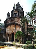 Nava-ratna Sridharjiu temple
 -
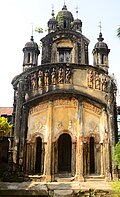 Sridhar jiu temple
 -
 Terracotta figurines
 -
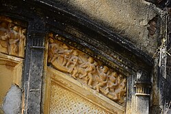 Terracotta figurines


The pictures are a part of Wiki Explores Paschim Medinipur programme, an initiative by West Bengal Wikimedians User Group
References
- ↑ Murshid, Ghulam. "Vidyasagar, Pundit Iswar Chandra". Banglapedia. Retrieved 24 July 2016.
- ↑ "Ishwar Chandra Vidyasagar". www.whereincity.com. Retrieved 24 July 2016.
- ↑ "District Human Development Report Paschim Medinipur, 2011". page 27-28. Department of Planning and Statistics, Government of West Bengal. Retrieved 10 September 2020.
- ↑ "District Statistical Handbook Paschim Medinipur, 2013". Table 2.2, 2.4 (a). Department of Planning and Statistics. Retrieved 10 September 2020.
- ↑ "CD block Wise Primary Census Abstract Data(PCA)". West Bengal – District-wise CD blocks. Registrar General and Census, India. Retrieved 25 August 2020.
- ↑ "Lachhipur B.H. School U. Pry". Schools.org. Retrieved 25 August 2020.
- ↑ McCutchion, David J., Late Mediaeval Temples of Bengal, first published 1972, reprinted 2017, page 53,77. The Asiatic Society, Kolkata, ISBN 978-93-81574-65-2
External links


 | This article about a location in the Paschim Medinipur district of West Bengal is a stub. You can help Bharatpedia by expanding it. |