Pulwama district
This article has multiple issues. Please help improve it or discuss these issues on the talk page. (Learn how and when to remove these template messages)
|
Pulwama District
Pulwom, Pulgom | |
|---|---|
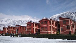
 Islamic University of Science and Technology | |
 | |
| Country | |
| Union Territory | Jammu and Kashmir |
| Headquarters | Pulwama |
| Area | |
| • Total | 1,090 km2 (420 sq mi) |
| Elevation | 1,630 m (5,350 ft) |
| Population (2021(estimated)) | |
| • Total | 615,429 |
| • Density | 560/km2 (1,500/sq mi) |
| • Literacy | 65.3% |
| Languages | |
| • Official | Kashmiri, Urdu, Hindi, Dogri, English[2][3] |
| Website | http://pulwama.gov.in |
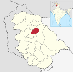
The Pulwama district is a district in the Indian Union territory of Jammu and Kashmir, located in the south of Srinagar. The district headquarters of Pulwama district are located in Pulwama city.[4]
Administration[edit]
In 1979 Anantnag district split in two, with one part remaining as Anantnag district, and the other part becoming Pulwama district.[5] When created, Pulwama district had 550 villages, grouped in five subdistricts (tehsils): Shopian, Awantipora, Pampore, Pulwama, and Tral.[6] After Shopian district was created in 2007, Pulwama district had 331 villages and four subdistricts.[6] According to the district administration, the area of the district is 420 square miles (1,090 km2).[1]
Pulwama district currently has eight subdistricts,[7] with 327 villages (eight of which are uninhabited):[1]
Tehsils[edit]
- Awantipora Tehsil
- Pampore Tehsil
- Pulwama Tehsil
- Tral Tehsil
- Rajpora Tehsil
- Aripal Tehsil
- Shahoora (Litter) Tehsil
- KakaporaTehsil
This district consists of five development blocks: Tral, Keller, Pampore, Pulwama and Kakapora.[8] Each block consists of a number of panchayats.
Demographics[edit]
According to the 2011 census Pulwama district has a population of 560,440,[9] roughly equal to the nation of Solomon Islands[10] or the US state of Wyoming.[11] This gives it a ranking of 537th in India (out of a total of 640).[9] The district has a population density of 598 inhabitants per square kilometre (1,550/sq mi).[9] Its population growth rate over the decade 2001–2011 was 29.18%.[9] Pulwama has a sex ratio of 912 females for every 1000 males[9] (though this varies with religion), and is lower than the national average of 940, and a literacy rate of 64.3%.[9]
| Pulwama district: religion, gender ratio, and % urban of population, according to the 2011 Census.[12] | |||||||||
|---|---|---|---|---|---|---|---|---|---|
| Hindu | Muslim | Christian | Sikh | Buddhist | Jain | Other | Not stated | Total | |
| Total | 13,840 | 535,159 | 1,109 | 9,440 | 35 | 6 | 18 | 833 | 560,440 |
| 2.47% | 95.49% | 0.20% | 1.68% | 0.01% | 0.00% | 0.00% | 0.15% | 100.00% | |
| Male | 12,515 | 274,104 | 818 | 5,111 | 26 | 4 | 10 | 476 | 293,064 |
| Female | 1,325 | 261,055 | 291 | 4,329 | 9 | 2 | 8 | 357 | 267,376 |
| Gender ratio (% female) | 9.6% | 48.8% | 26.2% | 45.9% | 25.7% | 33.3% | 44.4% | 42.9% | 47.7% |
| Sex ratio (no. of females per 1,000 males) |
106 | 952 | 356 | 847 | – | – | – | 750 | 912 |
| Urban | 7,388 | 72,353 | 223 | 364 | 12 | 3 | 4 | 115 | 80,462 |
| Rural | 6,452 | 462,806 | 886 | 9,076 | 23 | 3 | 14 | 718 | 479,978 |
| % Urban | 53.4% | 13.5% | 20.1% | 3.9% | 34.3% | 50.0% | 22.2% | 13.8% | 14.4% |
At the time of the 2011 census, 91.30% of the population spoke Kashmiri, 3.96% Gojri, 1.38% Punjabi and 1.25% Hindi as their first language.[14]
Healthcare[edit]
This section does not cite any sources. (July 2021) |
District has got one of the best health care system in The State/Union Territory. District has 1 DNB Deemed District Hospital Pulwama , 3 Sub-District Hospitals and numerous other health institutions. 1 tertiary Healthcare institute is under construction in Awantipora Tehsil of the district. It will be the largest hospital in Kashmir province/division.
Educational institutions[edit]
Some of the notable educational institutions of Pulwama district:
- AIIMS Awantipora, Pulwama
- Boys Government Degree College, Pulwama
- Islamic University, Pulwama
- Women's College, Pulwama
- Paramount Institute of Education
- Govt. GNM Nursing College, Pulwama
- Phoenix Paramedical College, Pulwama
- Dolphin Paramedical College, Pulwama
Land use[edit]
The "reporting area" is the area for which data on land use classification are available. When Pulwama district was created in 1979 it had a "reporting area" of 380 square miles (980 km2).[6] After the creation of Shopian district in 2007, the "reporting area" of Pulwama district was reduced to 240 square miles (610 km2).[6]
| Classification of use | Area in 2016–2017[15] | % total area | |
|---|---|---|---|
| sq miles | sq km | ||
| Forests | 1.6 | 4 | 0.4% |
| Area under non-agricultural uses (roads, railways, buildings, rivers, canals) | 32.4 | 84 | 8% |
| Barren and un-culturable land (mountains, deserts, etc.) | 9.8 | 25 | 2% |
| Permanent pastures and other grazing lands | 23.0 | 60 | 5% |
| Land under miscellaneous tree crops, etc. | 4.3 | 11 | 1% |
| Culturable waste land (land that could be cultivated, that has not been cultivated in the last five years) | 14.0 | 36 | 3% |
| Fallow lands other than current fallows (fallow for more than one year, which had been cultivated with the past five years) | 0.7 | 2 | 0.2% |
| Current fallows (fallow this year, but cultivated the previous year) | 24.6 | 64 | 6% |
| Net area sown (the total area sown with crops and orchards) | 124.7 | 323 | 30% |
| Reporting area | 234.6 | 608 | 56% |
| No data | 186.1 | 482 | 44% |
| Total area[1] | 420.9 | 1,090 | 100% |
| Definitions of land use classifications are given at: "Nine-fold classification of Land Use", Ministry of Statistics and Programme Implementation, Government of India, retrieved 22 July 2020 | |||
See also[edit]
References[edit]
- ↑ 1.0 1.1 1.2 1.3 "About District", Pulwama District, Government of Jammu and Kashmir, retrieved 22 July 2020
- ↑ "The Jammu and Kashmir Official Languages Act, 2020" (PDF). The Gazette of India. 27 September 2020. Retrieved 27 September 2020.
- ↑ "Parliament passes JK Official Languages Bill, 2020". Rising Kashmir. 23 September 2020. Retrieved 23 September 2020.
- ↑ "Pulwama", District Administration, Pulwama, Jammu And Kashmir. Developed And Hosted By National Informatics Centre, Ministry Of Electronics & Information Technology, Government Of India, retrieved 19 January 2021
- ↑ "About District/", District Anantnag, Government of Jammu and Kashmir, retrieved 23 July 2020
- ↑ 6.0 6.1 6.2 6.3 "District background". Pulwama District, Government of Jammu and Kashmir. Archived from the original on 28 May 2014. Retrieved 17 December 2014.
- ↑ "About District/ Administrative Setup/ Tehsil", Pulwama District, Government of Jammu and Kashmir, retrieved 22 July 2020
- ↑ Statement showing the number of blocks in respect of 22 Districts of Jammu and Kashmir State including newly Created Districts Archived 2008-09-10 at the Wayback Machine dated 2008-03-13, accessed 2008-08-30
- ↑ 9.0 9.1 9.2 9.3 9.4 9.5 "District Census 2011". Census2011.co.in. 2011. Retrieved 30 September 2011.
- ↑ US Directorate of Intelligence. "Country Comparison:Population". Retrieved 1 October 2011.
Solomon Islands 571,890 July 2011 est.
- ↑ "2010 Resident Population Data". U. S. Census Bureau. Retrieved 30 September 2011.
Wyoming 563,626
- ↑ 12.0 12.1 C-1 Population By Religious Community – Jammu & Kashmir (Report). Office of the Registrar General & Census Commissioner, India. Retrieved 28 July 2020.
- ↑ "Pulwama district population". Census India 2011. Retrieved 10 July 2021.
- ↑ 14.0 14.1 C-16 Population By Mother Tongue – Jammu & Kashmir (Report). Office of the Registrar General & Census Commissioner, India. Retrieved 18 July 2020.
- ↑ "Demography", Pulwama District, Government of Jammu and Kashmir, retrieved 22 July 2020
Note that this is marked square kilometres, but the numbers are actually hectares.