


>GreenC bot Rescued 2 archive links; reformat 1 link. Wayback Medic 2.5 |
m updated page |
||
| Line 1: | Line 1: | ||
{{Short description|Mountain in Tamilnadu, Southern India}} | |||
{{More citations needed|date=June 2012}} | |||
{{Use dmy dates|date=July 2019}} | {{Use dmy dates|date=July 2019}} | ||
{{Use Indian English|date=July 2019}} | {{Use Indian English|date=July 2019}} | ||
{{Infobox mountain | {{Infobox mountain | ||
| name = | | name = Agathiyar Malai | ||
| | | image = Agasthyarkoodam.JPG | ||
| | | image_size = 280px | ||
| | | image_caption = A view of Agastyaarkoodam from the base | ||
| elevation_m = | | elevation_m = 1869 | ||
| elevation_ref = | | elevation_ref = | ||
| prominence_m = 1, | | prominence_m = 1,510 | ||
| prominence_ref= | | prominence_ref= <ref>{{cite web | url=https://worldribus.org/indian-subcontinent/ | title=Indian Subcontinent - World Ribus | date=17 April 2025 }}</ref> | ||
| | | listing = [[Ultra-prominent peak|Ultra]], Ribu | ||
| | | location = [[Tamil Nadu]], India | ||
| location = | |||
India | |||
| range = [[Western Ghats]] | | range = [[Western Ghats]] | ||
| map = India | | map = India | ||
| range_coordinates = | | range_coordinates = | ||
| coordinates = {{coord|8| | | coordinates = {{coord|8|36|58.64|N|77|14|44.62|E|type:mountain_region:IN_scale:100000|format=dms|display=inline,title}} | ||
}} | }} | ||
''' | '''Agathiyar Malai''' (or '''Agasthiyarkoodam''') is one of the peaks of the [[Agathiyarmalai Biosphere Reserve]] in the [[Western Ghats]] that lies between the districts of [[Tirunelveli District]] of [[Tamil Nadu]] and [[Thiruvananthapuram District]] of [[Kerala]], [[India]].<ref>[https://www.google.com/maps/place/Agasthyamalai/@8.6088806,77.2442024,14z/data=!4m5!3m4!1s0x3b044a7eaa5b040f:0x7816ced6458f2c6f!8m2!3d8.6163066!4d77.2460479 Google Maps]</ref> This peak is specifically located in the [[Thiruvananthapuram district]] of [[Kerala]], near the Tamil Nadu border. It is 1,868-metres (6,129 ft) tall.{{citation needed|date=June 2024}}. The perennial [[Thamirabarani River]] originates from the eastern side of the range and flows into the Tirunelveli district of Tamil Nadu. The rivers flowing westwards through the district of [[Thiruvananthapuram]] in [[Kerala]] are the [[Karamana River]] and the [[Neyyar river]]. | ||
Agastyaarkoodam is a major trekking spot in the southern end of the [[Western Ghats]]. It is also considered as a pilgrimage spot for devotees of the Hindu sage [[Agastya]], who is considered to be one of the seven [[rishis]] ([[Saptarishi]]) of [[Hindu]] [[Puranas]]. In Tamil traditions, Agastya is considered as the father of the [[Tamil language]] and the compiler of the first Tamil grammar called [[Agattiyam]] or Akattiyam.<ref>[Richard S Weiss 2009, pp. 50–51, 81–82] and [Klaus Klostermaier (2003), A Concise Encyclopedia of Hinduism, Oxford: Oneworld Publications; {{ISBN|1-85168-175-2}}, page 17]</ref> There is a small stone statue of Agathiyar at the top of the peak where one can offer flowers as offerings to the mystical sage considered as a “Chiranjeevi” which means [[Immortality|immortal]]. | |||
Agasthyamala Biosphere Reserve is among 20 new sites added by UNESCO to its World Network of Biosphere Reserves in March 2016. The International Co-ordinating Council added the new sites during a two-day meeting on 19 March 2016 in Lima, bringing the total number of biosphere reserves to 669 sites in 120 countries, including 16 transboundary sites. | Agasthyamala [[Biosphere Reserve]] is among 20 new sites added by [[UNESCO]] to its [[World Network of Biosphere Reserves]] in March 2016. The International Co-ordinating Council added the new sites during a two-day meeting on 19 March 2016 in Lima, bringing the total number of biosphere reserves to 669 sites in 120 countries, including 16 transboundary sites. The [[Nature reserve|biosphere reserve]] includes close to 300 rare bird species and more than 200 medicinal plants endemic to this region.<ref>{{cite news | url=https://economictimes.indiatimes.com/news/politics-and-nation/indias-agasthyamala-listed-among-20-world-biosphere-reserves/articleshow/51491925.cms | title=UNESCO added Agasthya Mala to its World Network of Biosphere Reserves in 2016 | date=21 March 2016 | newspaper=The Economic Times | agency=PTI | access-date=12 July 2016 }}</ref> | ||
== Name == | |||
Named after the sage [[Agastya]], the official Survey of India name for the mountain is '''''Agastya Mala''''' (Malayalam: അഗസ്ത്യ മല, lit. ''Mount Agastya''). | |||
The mountain is also known as '''''Agastyarkoodam''''' (Malayalam: അഗസ്ത്യകൂടം, lit. ''the abode of Agastya'') and '''''Agastya Malai''''' (Tamil: அகத்தியமலை, lit. ''Agastya Hill''). | |||
==Geography== | ==Geography== | ||
Agasthya malai is 32 km from [[Neyyar Dam]] and 22 km from [[Bonacaud]], near [[Ponmudi|Vithura & Ponmudi]]. The major city and airport nearest to Agastyaarkoodam is [[Thiruvananthapuram]] and its [[Thiruvananthapuram International Airport]], around 61 km away. The nearest railway stations are Thiruvananthapuram, Kerala and [[Ambasamudram]], [[Tirunelveli District]], Tamil Nadu. The trekking path, nearly 22 km, is from [[Bonacaud]].{{citation needed|date=June 2024}} | |||
[[Kalakkad Mundanthurai Tiger Reserve]] is part of the [[Agasthyamala Biosphere Reserve|Agastyaarkoodam range]]. Part of the peak can be seen from the Upper Kodayar region. | |||
[[Kalakkad Mundanthurai Tiger Reserve]] is part of the [[Agasthyamala Biosphere Reserve| | |||
[[File:A view of the Agasthyamalai range from Upper Kodayar.jpg|thumb|center|A view of the Agasthyamalai range from Upper Kodayar]] | [[File:A view of the Agasthyamalai range from Upper Kodayar.jpg|thumb|center|A view of the Agasthyamalai range from Upper Kodayar]] | ||
Other major rivers which originate from the mountain are the [[Karamana River]], which flows through the [[Thiruvananthapuram district]] and is the major source of drinking water to the city, and the [[Neyyar River]] (also in the Thiruvananthapuram district).{{citation needed|date=June 2024}} | |||
Other major rivers which originate from the mountain are the [[Karamana River]], which flows through the [[Thiruvananthapuram district]] and is the major source of drinking water to the city, and the [[Neyyar River]] (also in the Thiruvananthapuram district). | |||
=== Trekking routes === | === Trekking routes === | ||
[[File:Athirumala Base Station in Agastya Mala.jpg|thumb|Athirumala Base Station in Agastya Mala]] | [[File:Athirumala Base Station in Agastya Mala.jpg|thumb|Athirumala Base Station in Agastya Mala]] | ||
The peak of | The peak of Agastyaarkoodam<ref>{{cite web|url=http://www.xploresouth.in/2011/09/agasthyarkoodamagasthyamala-heaven-for.html|title=Agastyaarkoodam-Agasthyamala- heaven for trekkers-hill station-Bird watchers paradise-reserve forest in Kerala - XploreSouth|work=xploresouth.in|access-date=26 September 2015|archive-url=https://web.archive.org/web/20150927085125/http://www.xploresouth.in/2011/09/agasthyarkoodamagasthyamala-heaven-for.html|archive-date=27 September 2015|url-status=dead}}</ref> can be reached only by trekking up to it. Trekking<ref>{{cite web|url=http://www.keralatripguide.com/thiruvananthapuram/agasthyakoodam-trek.html|title=Agasthyakoodam Trek|work=keralatripguide.com}}</ref> is allowed based on strict guidelines and is open to pilgrims during January to mid-March. Trekking passes are issued by [[Kerala Forest Department]] from the district office at [[Trivandrum]].<ref>{{cite web|url=http://news.entecity.com/passes-for-visiting-agasthyakoodam-from-january-9/|title=Passes for visiting Agasthyakoodam from January 9|work=EnteCity News}}</ref><ref>{{cite web|url=http://www.yentha.com/news/view/1/no-plastic-this-time-to-agasthyarkoodam-trek-starts-15-jan-|title=No Plastic This Time To Agastyaarkoodam; Trek Starts 15 Jan - Trivandrum News - Yentha.com|work=yentha.com}}</ref> The trekking route starts from [[Bonacaud]]. The route "Neyyar-Agasthyakoodam" is not open to the public. | ||
Vehicles reach only till [[Bonacaud]] which is around 50 km from [[Thiruvananthapuram]]. The trek to the peak is 20 km long from [[Bonacaud]] and requires two days. The first part of the trek can be started from the base station [[Bonacaud]] in the early morning and is 14 km through the forest to the camp. Elephants and wild bulls are in abundance in this part especially in the evenings. The final part i.e. the 6 km long trek can be done from the camp to the top of Agathyakoodam mountain on the second day. | Vehicles reach only till [[Bonacaud]] which is around 50 km from [[Thiruvananthapuram]]. The trek to the peak is 20 km long from [[Bonacaud]] and requires two days. The first part of the trek can be started from the base station [[Bonacaud]] in the early morning and is 14 km through the forest to the camp. Elephants and wild bulls are in abundance in this part, especially in the evenings. The final part i.e. the 6 km long trek can be done from the camp and crossing the border enters Tamil Nadu to reach the top of Agathyakoodam mountain on the second day. | ||
[[File:An old rock broken apart by nature in Agasthyamala before reaching Agasthya muni idol.jpg|center|thumb|An old rock broken apart by nature in Agasthyamala before reaching Agasthya muni idol.]] | [[File:An old rock broken apart by nature in Agasthyamala before reaching Agasthya muni idol.jpg|center|thumb|An old rock broken apart by nature in Agasthyamala before reaching Agasthya muni idol.]] | ||
[[File:Agasthyakoodamtrek.jpg|thumb|Agasthyakoodam Trek Route]] | [[File:Agasthyakoodamtrek.jpg|thumb|Agasthyakoodam Trek Route]] | ||
==Vegetation== | ==Vegetation== | ||
The lower elevations of this peak are known for their abundance of rare herbs and medicinal plants. Around 2,000 medicinal plants used in [[Siddha|Ayurvedic]] treatments are found here. Europeans, particularly those from [[England]], were the first to establish tea gardens around the base stations of the mountain at | {{Unreferenced section |date=June 2024}} | ||
The lower elevations of this peak are known for their abundance of rare herbs and medicinal plants. Around 2,000 medicinal plants used in [[Siddha|Ayurvedic]] treatments are found here. Europeans, particularly those from [[England]], were the first to establish tea gardens around the base stations of the mountain at Brimore, [[Bonacaud]], and [[Ponmudi]]. | |||
The [[Agasthyamala Biosphere Reserve]] harbours rare flora and fauna. Tourists are permitted to the area only with permission from the forest department of [[Kerala]]. Annual trekking passes to the peak are issued from the forest department during January–February only. | The [[Agasthyamala Biosphere Reserve]] harbours rare flora and fauna. Tourists are permitted to the area only with permission from the forest department of [[Kerala]]. Annual trekking passes to the peak are issued from the forest department during January–February only. | ||
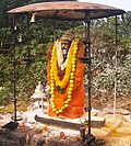
[[File:Agasthyamuni.jpg|right|thumb|180px|[[Murti]] of Agasthya Muni at the top of [[Agasthyamalai]] hill]] | [[File:Agasthyamuni.jpg|right|thumb|180px|[[Murti]] of Agasthya Muni at the top of [[Agasthyamalai]] hill]] | ||
==Manjolai Hills== | |||
{{Unreferenced section |date=June 2024}} | |||
Between elevations ranging from 1000 to 1500 metres, the Manjolai area is set deep within the Western Ghats within the Kalakkad Mundanthurai Tiger Reserve in the Tirunelveli District. Located on top of the Manimuthar Dam and the Manimuthar Water Falls, the Manjolai area has tea plantations, small settlements around the tea plantations, Upper Kodaiyar Dam, and a windy view point called Kuthiravetti. | Between elevations ranging from 1000 to 1500 metres, the Manjolai area is set deep within the Western Ghats within the Kalakkad Mundanthurai Tiger Reserve in the Tirunelveli District. Located on top of the Manimuthar Dam and the Manimuthar Water Falls, the Manjolai area has tea plantations, small settlements around the tea plantations, Upper Kodaiyar Dam, and a windy view point called Kuthiravetti. | ||
The tea plantations and the whole of Manjolai Estates are operated by the Bombay Burmah Trading Corporation Ltd on forest lands leased by the singampatti zamin. There are three tea estates in the Manjolai area — Manjolai Estate, Manimutharu Estate, and Oothu Estate. The estates are on elevations ranging between {{convert|2300|and|4200|ft|m|abbr=out|0}}. The estates, road, and the settlements in the Manjolai area are managed by the Bombay Burmah Trading Corporation Ltd. | The tea plantations and the whole of Manjolai Estates are operated by the Bombay Burmah Trading Corporation Ltd on forest lands leased by the singampatti zamin. There are three tea estates in the Manjolai area — Manjolai Estate, Manimutharu Estate, and Oothu Estate. The estates are on elevations ranging between {{convert|2300|and|4200|ft|m|abbr=out|0}}. The estates, road, and the settlements in the Manjolai area are managed by the Bombay Burmah Trading Corporation Ltd. | ||
== Former status prohibiting women == | == Former status prohibiting women == | ||
Prior to November 2018, women were forbidden to climb | Prior to November 2018, women were forbidden to climb Agastyaarkoodam by the local [[Kani tribe|Kani]] tribe. After a court ruling which removed the prohibition, a woman, Dhanya Sanal — an [[Indian Information Service]] officer — reached the peak in 2019, becoming the first woman known to make the climb. Since the change in the law, more than 100 other women have registered for a license to make the climb.<ref>{{cite web|last=Regan |first=Helen |url=https://edition.cnn.com/2019/01/17/asia/india-woman-mountain-kerala-intl/index.html |title=Indian woman is first to climb Kerala mountain reserved for men - CNN |publisher=CNN |date=2019-01-18 |access-date=2019-01-31}}</ref> | ||
==See also== | ==See also== | ||
| Line 84: | Line 75: | ||
{{Reflist| | {{Reflist| | ||
<ref>{{cite web|url=http://www.dnaindia.com/india/1262384/report-kerala-govt-removes-steve-irwin-s-name-from-croc-park |title=Kerala govt removes Steve Irwin's name from croc park - India - DNA |publisher=Dnaindia.com |access-date=2013-10-20}}</ref> | <ref>{{cite web|url=http://www.dnaindia.com/india/1262384/report-kerala-govt-removes-steve-irwin-s-name-from-croc-park |title=Kerala govt removes Steve Irwin's name from croc park - India - DNA |publisher=Dnaindia.com |access-date=2013-10-20}}</ref> | ||
<ref>{{cite web|url=http://www.hindu.com/2009/06/06/stories/2009060656400400.htm |archive-url=https://web.archive.org/web/20121109222330/http://www.hindu.com/2009/06/06/stories/2009060656400400.htm |url-status=dead |archive-date=2012-11-09 |title=Kerala News : Crocodile park sheds Steve | <ref>{{cite web|url=http://www.hindu.com/2009/06/06/stories/2009060656400400.htm |archive-url=https://web.archive.org/web/20121109222330/http://www.hindu.com/2009/06/06/stories/2009060656400400.htm |url-status=dead |archive-date=2012-11-09 |title=Kerala News : Crocodile park sheds Steve Irwin's name |date=2009-06-06 |work=[[The Hindu]] |access-date=2013-10-20}}</ref> | ||
}} | }} | ||
==External links== | ==External links== | ||
{{commons category | {{commons category}} | ||
* [https://web.archive.org/web/20121109222330/http://www.hindu.com/2009/06/06/stories/2009060656400400.htm Agasthya Crocodile Rehabilitation and Research Centre] | * [https://web.archive.org/web/20121109222330/http://www.hindu.com/2009/06/06/stories/2009060656400400.htm Agasthya Crocodile Rehabilitation and Research Centre] | ||
*[ | *[https://touristinindia.com/agasthyarkoodam-trekking-agasthyamalai/ Information on Agasthyarkoodam Trekking or Agasthyamalai Trekking ] | ||
{{Western Ghats}} | {{Western Ghats}} | ||
{{Tourism in Kerala}} | {{Tourism in Kerala}} | ||
Latest revision as of 10:47, 21 March 2026
 | This article needs more citations. (June 2012) |
| Agathiyar Malai | |
|---|---|
  Agathiyar Malai Tamil Nadu, India | |
| Highest point | |
| Elevation | 1,869 m (6,132 ft) |
| Prominence | 1,510 m (4,950 ft) [1] |
| Listing | Ultra, Ribu |
| Coordinates | 8°36′58.64″N 77°14′44.62″E / 8.6162889°N 77.2457278°E |
| Geography | |
| Location | Tamil Nadu, India |
| Parent range | Western Ghats |
Agathiyar Malai (or Agasthiyarkoodam) is one of the peaks of the Agathiyarmalai Biosphere Reserve in the Western Ghats that lies between the districts of Tirunelveli District of Tamil Nadu and Thiruvananthapuram District of Kerala, India.[2] This peak is specifically located in the Thiruvananthapuram district of Kerala, near the Tamil Nadu border. It is 1,868-metres (6,129 ft) tall.[citation needed]. The perennial Thamirabarani River originates from the eastern side of the range and flows into the Tirunelveli district of Tamil Nadu. The rivers flowing westwards through the district of Thiruvananthapuram in Kerala are the Karamana River and the Neyyar river.
Agastyaarkoodam is a major trekking spot in the southern end of the Western Ghats. It is also considered as a pilgrimage spot for devotees of the Hindu sage Agastya, who is considered to be one of the seven rishis (Saptarishi) of Hindu Puranas. In Tamil traditions, Agastya is considered as the father of the Tamil language and the compiler of the first Tamil grammar called Agattiyam or Akattiyam.[3] There is a small stone statue of Agathiyar at the top of the peak where one can offer flowers as offerings to the mystical sage considered as a “Chiranjeevi” which means immortal.
Agasthyamala Biosphere Reserve is among 20 new sites added by UNESCO to its World Network of Biosphere Reserves in March 2016. The International Co-ordinating Council added the new sites during a two-day meeting on 19 March 2016 in Lima, bringing the total number of biosphere reserves to 669 sites in 120 countries, including 16 transboundary sites. The biosphere reserve includes close to 300 rare bird species and more than 200 medicinal plants endemic to this region.[4]
Name[edit | edit source]
Named after the sage Agastya, the official Survey of India name for the mountain is Agastya Mala (Malayalam: അഗസ്ത്യ മല, lit. Mount Agastya).
The mountain is also known as Agastyarkoodam (Malayalam: അഗസ്ത്യകൂടം, lit. the abode of Agastya) and Agastya Malai (Tamil: அகத்தியமலை, lit. Agastya Hill).
Geography[edit | edit source]
Agasthya malai is 32 km from Neyyar Dam and 22 km from Bonacaud, near Vithura & Ponmudi. The major city and airport nearest to Agastyaarkoodam is Thiruvananthapuram and its Thiruvananthapuram International Airport, around 61 km away. The nearest railway stations are Thiruvananthapuram, Kerala and Ambasamudram, Tirunelveli District, Tamil Nadu. The trekking path, nearly 22 km, is from Bonacaud.[citation needed]
Kalakkad Mundanthurai Tiger Reserve is part of the Agastyaarkoodam range. Part of the peak can be seen from the Upper Kodayar region.

Other major rivers which originate from the mountain are the Karamana River, which flows through the Thiruvananthapuram district and is the major source of drinking water to the city, and the Neyyar River (also in the Thiruvananthapuram district).[citation needed]
Trekking routes[edit | edit source]

The peak of Agastyaarkoodam[5] can be reached only by trekking up to it. Trekking[6] is allowed based on strict guidelines and is open to pilgrims during January to mid-March. Trekking passes are issued by Kerala Forest Department from the district office at Trivandrum.[7][8] The trekking route starts from Bonacaud. The route "Neyyar-Agasthyakoodam" is not open to the public.
Vehicles reach only till Bonacaud which is around 50 km from Thiruvananthapuram. The trek to the peak is 20 km long from Bonacaud and requires two days. The first part of the trek can be started from the base station Bonacaud in the early morning and is 14 km through the forest to the camp. Elephants and wild bulls are in abundance in this part, especially in the evenings. The final part i.e. the 6 km long trek can be done from the camp and crossing the border enters Tamil Nadu to reach the top of Agathyakoodam mountain on the second day.


Vegetation[edit | edit source]
|
The lower elevations of this peak are known for their abundance of rare herbs and medicinal plants. Around 2,000 medicinal plants used in Ayurvedic treatments are found here. Europeans, particularly those from England, were the first to establish tea gardens around the base stations of the mountain at Brimore, Bonacaud, and Ponmudi.
The Agasthyamala Biosphere Reserve harbours rare flora and fauna. Tourists are permitted to the area only with permission from the forest department of Kerala. Annual trekking passes to the peak are issued from the forest department during January–February only.

Manjolai Hills[edit | edit source]
|
Between elevations ranging from 1000 to 1500 metres, the Manjolai area is set deep within the Western Ghats within the Kalakkad Mundanthurai Tiger Reserve in the Tirunelveli District. Located on top of the Manimuthar Dam and the Manimuthar Water Falls, the Manjolai area has tea plantations, small settlements around the tea plantations, Upper Kodaiyar Dam, and a windy view point called Kuthiravetti.
The tea plantations and the whole of Manjolai Estates are operated by the Bombay Burmah Trading Corporation Ltd on forest lands leased by the singampatti zamin. There are three tea estates in the Manjolai area — Manjolai Estate, Manimutharu Estate, and Oothu Estate. The estates are on elevations ranging between 2,300 and 4,200 feet (701 and 1,280 m). The estates, road, and the settlements in the Manjolai area are managed by the Bombay Burmah Trading Corporation Ltd.
Former status prohibiting women[edit | edit source]
Prior to November 2018, women were forbidden to climb Agastyaarkoodam by the local Kani tribe. After a court ruling which removed the prohibition, a woman, Dhanya Sanal — an Indian Information Service officer — reached the peak in 2019, becoming the first woman known to make the climb. Since the change in the law, more than 100 other women have registered for a license to make the climb.[9]
See also[edit | edit source]
- Agasthyamala Biosphere Reserve
- Indian Council of Forestry Research and Education
- Thamirabarani River
- Tirunelveli
- Papanasam
- Anamudi - Highest peak in Western Ghats
- Tourism in Thiruvananthapuram
References[edit | edit source]
- ↑ "Indian Subcontinent - World Ribus". 17 April 2025.
- ↑ Google Maps
- ↑ [Richard S Weiss 2009, pp. 50–51, 81–82] and [Klaus Klostermaier (2003), A Concise Encyclopedia of Hinduism, Oxford: Oneworld Publications; ISBN 1-85168-175-2, page 17]
- ↑ "UNESCO added Agasthya Mala to its World Network of Biosphere Reserves in 2016". The Economic Times. PTI. 21 March 2016. Retrieved 12 July 2016.
- ↑ "Agastyaarkoodam-Agasthyamala- heaven for trekkers-hill station-Bird watchers paradise-reserve forest in Kerala - XploreSouth". xploresouth.in. Archived from the original on 27 September 2015. Retrieved 26 September 2015.
- ↑ "Agasthyakoodam Trek". keralatripguide.com.
- ↑ "Passes for visiting Agasthyakoodam from January 9". EnteCity News.
- ↑ "No Plastic This Time To Agastyaarkoodam; Trek Starts 15 Jan - Trivandrum News - Yentha.com". yentha.com.
- ↑ Regan, Helen (18 January 2019). "Indian woman is first to climb Kerala mountain reserved for men - CNN". CNN. Retrieved 31 January 2019.
- ↑ "Kerala govt removes Steve Irwin's name from croc park - India - DNA". Dnaindia.com. Retrieved 20 October 2013.
- ↑ "Kerala News : Crocodile park sheds Steve Irwin's name". The Hindu. 6 June 2009. Archived from the original on 9 November 2012. Retrieved 20 October 2013.
External links[edit | edit source]
- Agasthya Crocodile Rehabilitation and Research Centre
- Information on Agasthyarkoodam Trekking or Agasthyamalai Trekking


- Pages using the JsonConfig extension
- Articles needing additional references from June 2012
- Pages using infobox mountain with unknown parameters
- Articles needing additional references from June 2024
- Mountains of the Western Ghats
- Tourist attractions in Thiruvananthapuram district
- Tourism in Kerala
- Mountains of Kerala
- Geography of Thiruvananthapuram district