

imported>Chandan Guha Stub tag removed |
small changes |
||
| Line 1: | Line 1: | ||
{{Use Indian English|date=January 2023}} | |||
{{Use dmy dates|date=June 2023}} | |||
{{Infobox settlement | {{Infobox settlement | ||
| name = Paikbheri | | name = Paikbheri | ||
| native_name = <!-- Please do not add any Indic script in this infobox, per | | native_name = <!-- Please do not add any Indic script in this infobox, per Bharatpedia:INDISCRIPT policy --> | ||
| native_name_lang = | | native_name_lang = | ||
| other_name = Paik Bheri | | other_name = Paik Bheri | ||
| Line 55: | Line 57: | ||
| footnotes = | | footnotes = | ||
}} | }} | ||
'''Paikbheri''' (also written as Paik Bheri) is a village in the [[Bhagabanpur I]] [[Community development blocks in India|CD block]] in the [[Egra subdivision]] of the [[Purba Medinipur district]] in the state of [[West Bengal]], [[India]]. | '''Paikbheri''' (also written as Paik Bheri) is a village in the [[Bhagabanpur I]] [[Community development blocks in India|CD block]] in the [[Egra subdivision]] of the [[Purba Medinipur district]] in the state of [[West Bengal]], [[India]]. | ||
==Geography== | ==Geography== | ||
| Line 77: | Line 79: | ||
|mark-coord15={{coord|22|1|50|N|87|48|40|E}} | label-pos15=left|label15= Kajlagarh| numbered15=R| mark-title15= [[Kajlagarh]] (R)|shape-color15=#C40000 | |mark-coord15={{coord|22|1|50|N|87|48|40|E}} | label-pos15=left|label15= Kajlagarh| numbered15=R| mark-title15= [[Kajlagarh]] (R)|shape-color15=#C40000 | ||
|mark-coord16={{coord|22.110011|N|87.555306|E}}| label16=Haldi River| label-color16 = #77A1CB| label-angle16=-5| label-pos16=right| label-size16=10| mark-size16=0| mark-title16=none | |mark-coord16={{coord|22.110011|N|87.555306|E}}| label16=Haldi River| label-color16 = #77A1CB| label-angle16=-5| label-pos16=right| label-size16=10| mark-size16=0| mark-title16=none | ||
|mark-coord17={{coord|22|6|49|N|87|43|24|E}} | label-pos17=left|label17= Paikbheri| numbered17=H| mark-title17= | |mark-coord17={{coord|22|6|49|N|87|43|24|E}} | label-pos17=left|label17= Paikbheri| numbered17=H| mark-title17= Paikbheri (H)|shape-color17=black| label-size17=13|label-color17=black <!-- make the subject of the article stand out with black colors --> | ||
|mark-coord18={{coord|21|49|59|N|87|27|9|E}} | label-pos18=right|label18= Panchrol| numbered18=H| mark-title18= [[Panchrol]] (H)| shape-color18=#AA6666 | |mark-coord18={{coord|21|49|59|N|87|27|9|E}} | label-pos18=right|label18= Panchrol| numbered18=H| mark-title18= [[Panchrol]] (H)| shape-color18=#AA6666 | ||
|mark-coord19={{coord|21|51|12|N|87|28|3|E}} | label-pos19=right|label19= Alangiri| numbered19=H| mark-title19= [[Alangiri]] (H)| shape-color19=#AA6666}} | |mark-coord19={{coord|21|51|12|N|87|28|3|E}} | label-pos19=right|label19= Alangiri| numbered19=H| mark-title19= [[Alangiri]] (H)| shape-color19=#AA6666}} | ||
| Line 85: | Line 87: | ||
===Urbanisation=== | ===Urbanisation=== | ||
96.96% of the population of Egra subdivision live in the rural areas. Only 3.04% of the population live in the urban areas, and that is the lowest proportion of urban population amongst the four subdivisions in Purba Medinipur district.<ref>{{cite web | url = http://wbpspm.gov.in/publications/District%20Statistical%20Handbook | title = District Statistical Handbook 2014 Purba Medinipur | work = Table 2.2 | publisher = Department of Planning and Statistics, Government of West Bengal | access-date = 12 August 2020 }}</ref> | 96.96% of the population of Egra subdivision live in the rural areas. Only 3.04% of the population live in the urban areas, and that is the lowest proportion of urban population amongst the four subdivisions in Purba Medinipur district.<ref>{{cite web | url = http://wbpspm.gov.in/publications/District%20Statistical%20Handbook | title = District Statistical Handbook 2014 Purba Medinipur | work = Table 2.2 | publisher = Department of Planning and Statistics, Government of West Bengal | access-date = 12 August 2020 | archive-date = 21 January 2019 | archive-url = https://web.archive.org/web/20190121045803/http://www.wbpspm.gov.in/publications/District%20Statistical%20Handbook | url-status = dead }}</ref> | ||
<small>Note: The map alongside presents some of the notable locations in the subdivision. All places marked in the map are linked in the larger full screen map.</small> | <small>Note: The map alongside presents some of the notable locations in the subdivision. All places marked in the map are linked in the larger full screen map.</small> | ||
| Line 93: | Line 95: | ||
==Culture== | ==Culture== | ||
[[David McCutchion|David J. McCutchion]] mentions the Shyama Sundara temple as a plain ''flat-roofed'' structure with ''[[Bengal temple architecture#Ratna temple|pancha-ratna]]'' superstructure measuring | [[David McCutchion|David J. McCutchion]] mentions the Shyama Sundara temple as a plain ''flat-roofed'' structure with ''[[Bengal temple architecture#Ratna temple|pancha-ratna]]'' superstructure measuring 28’9" x 25’7" and possibly built in 1730. There is a ''char-chala'' [[porch]] measuring 19’4" sq plus 17’9" sq attached to a deul.<ref>McCutchion, David J., ''Late Mediaeval Temples of Bengal'', first published 1972, reprinted 2017, pages 67, 71. The Asiatic Society, Kolkata, {{ISBN| 978-93-81574-65-2}}</ref> | ||
==Paikbheri picture gallery== | ==Paikbheri picture gallery== | ||
| Line 101: | Line 103: | ||
File:Shyama Sundara flat roofed temple with panacharatna at Paikbheri under Purba Medinipur district in West Bengal 02.jpg|Shyama Sundara flat-roofed temple with pancha-ratna | File:Shyama Sundara flat roofed temple with panacharatna at Paikbheri under Purba Medinipur district in West Bengal 02.jpg|Shyama Sundara flat-roofed temple with pancha-ratna | ||
</gallery> | </gallery> | ||
==References== | ==References== | ||
Latest revision as of 13:20, 22 July 2025
Paikbheri
Paik Bheri | |
|---|---|
Village | |
Paikbheri is located in West Bengal  Paikbheri Location in West Bengal, India  Paikbheri Paikbheri (India) | |
| Coordinates: 22°06′09″N 87°43′24″E / 22.1025°N 87.7234°E | |
| Country |  India India |
| State | West Bengal |
| District | Purba Medinipur |
| Population (2011) | |
| • Total | 1,124 |
| Languages | |
| • Official | Bengali, English |
| Time zone | UTC+5:30 (IST) |
| PIN | 721601 |
| Telephone/STD code | 03228 |
| Lok Sabha constituency | Kanthi |
| Vidhan Sabha constituency | Bhagabanpur |
| Website | purbamedinipur |
Paikbheri (also written as Paik Bheri) is a village in the Bhagabanpur I CD block in the Egra subdivision of the Purba Medinipur district in the state of West Bengal, India.
Geography[edit | edit source]
Lua error in Module:OSM_Location_map at line 1984: attempt to index field 'wikibase' (a nil value).
Location[edit | edit source]
Paikbheri is located at 22°06′09″N 87°43′24″E / 22.1025°N 87.7234°E.
Urbanisation[edit | edit source]
96.96% of the population of Egra subdivision live in the rural areas. Only 3.04% of the population live in the urban areas, and that is the lowest proportion of urban population amongst the four subdivisions in Purba Medinipur district.[1]
Note: The map alongside presents some of the notable locations in the subdivision. All places marked in the map are linked in the larger full screen map.
Demographics[edit | edit source]
According to the 2011 Census of India, Paikbheri had a total population of 1,124, of which 577 (51%) were males and 547 (49%) were females. There were 985 persons in the age range of 0–6 years. The total number of literate persons in Paikbheri was 910 (92.39% of the population over 6 years).[2]
Culture[edit | edit source]
David J. McCutchion mentions the Shyama Sundara temple as a plain flat-roofed structure with pancha-ratna superstructure measuring 28’9" x 25’7" and possibly built in 1730. There is a char-chala porch measuring 19’4" sq plus 17’9" sq attached to a deul.[3]
Paikbheri picture gallery[edit | edit source]
-
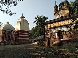 Shyma Sundara deul and flat-roofed temple
 -
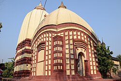 Shyama Sundara deul with char-chala porch in front
 -
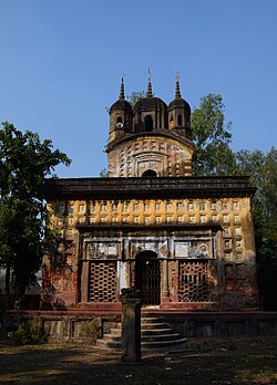 Shyama Sundara flat-roofed temple with pancha-ratna


References[edit | edit source]
- ↑ "District Statistical Handbook 2014 Purba Medinipur". Table 2.2. Department of Planning and Statistics, Government of West Bengal. Archived from the original on 21 January 2019. Retrieved 12 August 2020.
- ↑ "CD block Wise Primary Census Abstract Data(PCA)". West Bengal – District-wise CD blocks. Registrar General and Census, India. Retrieved 12 August 2020.
- ↑ McCutchion, David J., Late Mediaeval Temples of Bengal, first published 1972, reprinted 2017, pages 67, 71. The Asiatic Society, Kolkata, ISBN 978-93-81574-65-2
External links[edit | edit source]
Cities, towns, locations and neighbourhoods in Purba Medinipur District | |||||||||
|---|---|---|---|---|---|---|---|---|---|
| Cities, municipal and census towns |
| ||||||||
| Locations other than cities and towns |
| ||||||||
| Neighbourhoods |
| ||||||||
| Related topics | |||||||||


