

CleanupBot (talk | contribs) m clean up |
m Cleanup |
||
| Line 1: | Line 1: | ||
{{Short description|in | {{Short description|Tourist places in Jammu and Kashmir}} | ||
{{Use dmy dates|date=March 2018}} | {{Use dmy dates|date=March 2018}} | ||
{{Use Indian English|date=March 2018}} | {{Use Indian English|date=March 2018}} | ||
[[File:Kashmir Spring.jpg|thumb|[[Kashmir Valley]] | {{manual|date=December 2022}} | ||
[[Jammu and Kashmir (union territory)|Jammu and Kashmir]] is home to several valleys such as the [[Kashmir Valley]], [[Chenab Valley]], [[Sindh Valley]] and [[Lidder Valley]]. Some major tourist attractions in Jammu and Kashmir are Srinagar, | [[File:Kashmir Spring.jpg|thumb|[[Kashmir Valley]] in the spring]] | ||
[[Jammu and Kashmir (union territory)|Jammu and Kashmir]] is home to several valleys such as the [[Kashmir Valley]], [[Chenab Valley]], [[Sindh Valley]] and [[Lidder Valley]]. Some major tourist attractions in Jammu and Kashmir are Srinagar, with its renowned [[Dal Lake]] and Mughal Gardens, [[Gulmarg]], [[Pahalgam]], [[Bhaderwah]], Patnitop and Jammu. Every year, thousands of Hindu [[pilgrim]]s visit holy shrines of [[Vaishno Devi]] and [[Amarnath Temple|Amarnath]] which has had a significant impact on the state's economy.<ref>{{cite news |url=http://www.hindu.com/thehindu/holnus/002200709130350.htm |work=Online edition of The Hindu |title=Amarnath Board to study yatra impact on Kashmir economy |access-date=6 June 2009 |location=Chennai, India |date=13 September 2007 |archive-date=9 November 2012 |archive-url=https://web.archive.org/web/20121109091413/http://www.hindu.com/thehindu/holnus/002200709130350.htm |url-status=dead }}</ref> | |||
Kashmir Valley is one of the top tourist destinations of India.<ref>{{cite news|url=http://www.hindu.com/thehindu/holnus/004200903181221.htm|work=Online edition of The Hindu|title=Foreign tourists flock Kashmir|access-date=18 March 2009|location=Chennai, India|date=18 March 2009}}</ref> | Kashmir Valley is one of the top tourist destinations of India.<ref>{{cite news|url=http://www.hindu.com/thehindu/holnus/004200903181221.htm|work=Online edition of The Hindu|title=Foreign tourists flock Kashmir|access-date=18 March 2009|location=Chennai, India|date=18 March 2009|archive-date=9 November 2012|archive-url=https://web.archive.org/web/20121109091716/http://www.hindu.com/thehindu/holnus/004200903181221.htm|url-status=dead}}</ref> Gulmarg, one of the most popular [[ski resort]] destinations in India, is also home to the world's highest green [[golf course]].<ref>{{cite web|url=https://www.wsj.com/articles/SB119332713217271534?mod=googlenews_wsj|title=Fairway to Heaven|author=Cris Prystay|date=26 October 2007|work=The Wall Street Journal}}</ref> Tourism has declined in the past thirty years.<ref>{{cite web|url=http://sify.com/news/Tourists-arrival-gives-boost-to-J-K-economy-news-jm3v4cihjai.html|archive-url=https://web.archive.org/web/20110716071016/http://www.sify.com/news/Tourists-arrival-gives-boost-to-J-K-economy-news-jm3v4cihjai.html|url-status=dead|archive-date=2011-07-16|title=Tourists arrival gives boost to J-K economy|work=Sify}}</ref> | ||
Jammu and Kashmir | Jammu and Kashmir also has flower gardens and apple orchards. It attracts tourists for its handicrafts and the [[Kashmir shawl|Kashmiri shawls]]. | ||
==Major attractions== | == Major attractions in North Kashmir == | ||
The first ever Map of Tourism in Jammu and Kashmir was published in "Konnect Magazine"{{citation needed|date=December 2022}} and then on official Twitter handle of Jammu and Kashmir Tourism.<ref>{{Cite tweet |user=jandktourism |number=1582401035834126337 |url=https://twitter.com/jandktourism/status/1582401035834126337 |access-date=2023-05-25 |title=How many places have you visited? |url-status=live |archive-date=2022-12-11 |archive-url=https://web.archive.org/web/20221211160946/https://twitter.com/jandktourism/status/1582401035834126337 |language=en}}</ref> North Kashmir is located mostly in the Himalayan mountains.<ref>{{Cite web |last=KNO |title=Tourists throng LoC villages in north Kashmir |url=https://www.greaterkashmir.com/kashmir/tourists-throng-loc-villages-in-north-kashmir |access-date=2022-10-26 |website=Greater Kashmir |language=en}}</ref> | |||
=== Bangus Valley === | |||
Between the green hills, streams, and meadows lie a valley In Jammu and Kashmir's Kupwara where the cattle run wild, birds sing lullabies through the day.{{citation needed|date=December 2022}} The place is named [[Bangus Valley]]. According to a report,{{clarify|reason=What report?|date=December 2022}} the valley is located nearly 10,000 meters above sea level (MSL). The Bangus Valley is located in Kupwara district of North Kashmir. It is situated to the West of [[Handwara]] town along the Mawri River within the Handwara sub-district. district Kupwara. The term ''Bangus'' comes from Sanskrit word ''Van'' (Forest) and ''gus'' (grass).The valley is nearly 130 km from Srinagar and is situated on the northwestern border of Tehsil Handwara in Kupwara. Divided into two parts-Bod Bungus (Big Bungus) and Lokut Bungus (Small Bungus) the valley spans over an area of 300 km<sup>2</sup>. Bangus is about {{convert|150|km|mi|abbr=off}} from [[Srinagar District|Srinagar]] at an altitude of {{convert|10,000|ft|m}}. The principal valley is locally known as "Boud Bangus" (Big Bangus) and has an estimated area of about 300 square kilometers. It consists of a linear elliptical bowl aligned along the east–west axis and is surrounded by Rajwar and Mawar in the east, Shamasbury and Dajlungun Mountains in the west and Chowkibal and Karnah Guli in the north. It is surrounded by the Shamsbery mountain range and the Leepa Valley, according to the report.{{clarify|reason=What report?|date=December 2022}} After years of planning,{{citation needed|date=December 2022}} Bangus was recently{{when|date=December 2022}} made motorable via the Mawer route while work is in full swing on the Chowkibal and Rajwar routes. Its high altitude and unpredictable weather conditions were a huge obstacle but the administration has materialized this project in a short span of time. The Centre recognised 75 new destinations in the Union Territory for tourism this year.{{when|date=December 2022}} Under the Jal Jeevan Mission and 'Har Ghar Nal Say Jal Mission, the water scarcity days of Kupwara are over. The district constructed 400 Amrit Sarovar in 2022 to support the safe drinking water initiative of the government. The Kupwara District Administration and Tourism Department organized a two-day Bangus Mela earlier this year in August. The event focused on the traditions and culture of the region.{{citation needed|date=December 2022}} Music artists, singers, Kashmiri Rowfdancers, and school report said.{{clarify|reason=What report?|date=December 2022}} children organized shows for the audience. Pony wallas also put up a special segment with the ponies displaying riding tricks and offering salami to the spectators. The festival folk songs were played nonstop which added to the upbeat atmosphere of the usually quiet valley.{{citation needed|date=December 2022}} | |||
The Lolab Bangus Drang yari Development Authority (LRDDA) installed night-stay tents for tourists. The meadows and slopes of Bungus are enveloped in flowers and medicinal plants such as Macrotima Benthami (gew zaban), Saussurea Sacra (Jugi pedshah), and Aconitum Heterophylleum (patrees). Recently{{when|date=December 2022}} a new species of flowering medicinal plant ‘Swertia Kashmirensis’ has been discovered in Bungus.{{citation needed|date=December 2022}} The fauna in Bungus includes musk deer, antelope, snow leopards, brown and black bears, monkeys, and red foxes. The bird species include pheasants, tragopan, black partridge, bush quail, and wildfowl. Until two years ago,{{when|date=December 2022}} the valley was not an easy destination due to its proximity to the LoC (5 km) but the reinstallation of better security systems after the abrogation of Article 370, has helped to increase the faith of explorers who earlier did not find it safe to visit. Previously, visitors had to obtain permits from the District Magistrate to trek and camp but with the ripple effect of the political developments has been so effective that all such restrictions have now been lifted.{{citation needed|date=December 2022}} | |||
As of 2 June 2022, the road connectivity from [[Handwara]] side via Mawer is complete. People can take only small cars to Bangus because work on macdamisation is still going on. Vehicles are available on rent basis from Handwara market. Night stay tents are also available there. There are three routes to visit this place. The least distance route from [[Handwara]] via Reshwari Mawer. The second route is also from [[Handwara]] but via Rajwar and is suitable for trekking only. The third route from [[Kupwara]] via Chowkibal. | |||
=== Bhadrakali Mandir === | |||
An ancient idol of Mata Bhadrakali was reinstalled at a temple in Jammu and Kashmir's Kupwara district years after it was brought back from Jammu. The ancient temple at Bhadrakali Village in Handwara wore a festive look as the original idol of the presiding deity, Maa Bhadrakali, was restored to its original abode in a simple ceremony in March 2019.<ref>{{Cite news |agency=Press Trust of India |date=2018-03-20 |title=Ancient idol of Maa Bhadrakali installed in Kupwara temple after 38 years |work=Business Standard India |url=https://www.business-standard.com/article/pti-stories/ancient-idol-of-maa-bhadrakali-installed-in-kupwara-temple-after-38-years-118032000766_1.html |access-date=2022-10-26}}</ref> The idol was stolen in 1981 was subsequently recovered and kept in Jammu since 1999. It is believed that during the exodus of Pandits from Handwara, the idol was left behind in the house of Pandit Jaggernath. The nearest airport is [[Sheikh ul-Alam International Airport]] in [[Srinagar]] located 78.8 kilometers from Handwara. Handwara is not yet connected to railways. The nearest railway station is [[Baramulla railway station]] located 30 kilometers from Handwara. Handwara is well-connected with roads and highways. The [[National Highway 701 (India)|NH 701]] passes through Handwara alongside other intra-town roads. | |||
=== Tithwal === | |||
[[Tithwal]] is a small border village about 171 km from Srinagar. After a scenic drive through Sopore, Kupwara and on to Tangdhar, one arrives at Tithwal. Another 80 km and on comes Sharda Peeth. Beyond the Sadhna top lies the Karnah valley along the river Kishan-Ganga and at the edge of it is the last village of North-West Kashmir, Tithwal. At 10600 feet, Sadhna pass<ref>{{Cite web |title=Sadhna Pass View Point {{!}} District Kupwara, Government of Jammu & Kashmir {{!}} India |url=https://kupwara.nic.in/tourist-place/sadhna/ |access-date=2022-11-14 |language=en-US}}</ref> nested on the mighty Shamshabari mountain ranges originally known as Nastachun Pass is the only access to the Karnah, Neelam and Leepa valley. In the olden days, Tithwal was the trading hub where hundreds of shops lined up selling ghee, honey and walnut kernels. Those commodities would reach Tithwal from Karnah, Leepa and Neelam valleys. To immerse fully into the surroundings, the Forest Department of J&K, like at many other places, have built Kail and Deodar huts.{{citation needed|date=December 2022}} To reach Tithwal one has to take NH1 from Airport road. After travelling for 45 km on NH1 take a right turn to Sangrama - Sopore road and then turn left onto Sopore - Kupwara road and then follow NH 701 to reach Tithwal. | |||
=== Ancient Stupa Parihaspora === | |||
Paraspore or [https://baramulla.nic.in/tourist-place/parihaspora/ Paraspur] is a small town 22 km North-West of [[Srinagar]] in the [[Kashmir]] Valley. It was built on a plateau above the [[Jhelum River]] by [[Lalitaditya Muktapida]]. Parihaspur lost its status as a capital after [[Lalitaditya Muktapida|Lalitaditya's]] death. His son moved the royal residence. The [[Jhelum River]] is to the northeast of Parihaspur as it meets the Sind Nallah at Shadpur sangam. In the past this confluence of the rivers occurred closer to Parihaspur. To reach Paraspore one has to head southwest on Airport Road, make a U-turn to hit NH1. Continue straight on NH1 past M.R. Brand for 55 km and turn left onto Baramula-Gulmarg road and stay on it for 1.2 km to reach the destination. | |||
=== Detha Mandir === | |||
The lord Detha temple<ref>{{cite web | url=https://travelthehimalayas.com/detha-daata-temple | title=Detha / Daata Temple }}</ref> is situated in a small village about 105 km from Srinagar. To reach this temple, one must take a long drive moving from Srinagar to Pattan and onwards to Uri. The century-old map is the key to understanding the wealth of Hindu heritage and culture that Kashmir was once renowned for. One of the most noted monuments documented by many archaeologists, historians and architects is the Datta Mandir located at Banihal near Uri.{{citation needed|date=December 2022}} To reach Detha Mandir one has to head Southwest on Airport Road, make a U-turn to hit NH1and drive for 3.8 km followed by a slight left onto NH1. After a drive of 15 km on NH1 past M.R. Brand, turn left after 1.2 km on to NH1. Stay on this road for 89 km until you reach Datta Temple, Uri. | |||
=== Gurudwara Thara Sahib, Baramulla === | |||
Baramulla is a boulevard surrounded by breathtaking rice fields and meadows. Baramulla is about 55 km from Srinagar. This historic shrine is 8 km away from Baramulla town and 01 km on Baramulla – Srinagar National highway. According to local history, a faqir named Balol and his disciples met Guru Sahib near Kalampura village. They discussed religious discourses with Guru Ji. At the request of people, Guru Ji dug out a fresh water chisma. In the last years of 19th century, a plate form (Thara) 20 x 25 ft. was constructed by S. Matwal Singh Sahni and other Gur Sikhs. Chief Khalsa Dewan Amritsar intellectuals like Bhai Vir Singh, S. Damodar Singh Engineer, S. Narinder Singh and others also visited this place and constructed a Gurdwara in 1928-1931 A.D. The Gurdwara is managed by Gurdwara Parbandhak Committee, Baramulla. To reach Gurudwara Thara Sahib one has to Head Southwest on Airport Road, make a U-turn to hit NH1and drive for 3.8 km followed by a slight left onto NH1. After a drive of 15 km on NH1 past M.R. Brand, turn left after 1.2 km on to NH1. Continue straight for 32 km passing Zehra Crossing and then turn left onto Singhpora-Delina Road. After driving for 2.9 km, turn right onto Singhpora-Kalampora Road for 260mtrs arriving at the destination | |||
==Major attractions in South Kashmir== | |||
=== Gulmarg === | === Gulmarg === | ||
{{excerpt|Gulmarg|Tourism}} | {{excerpt|Gulmarg|Tourism}} | ||
=== Jammu === | === Jammu === | ||
[[File:Jammu city.jpg|thumb| | [[File:View of Jammu city and the Tawi River.jpg|thumb|View of Jammu city and Tawi river]] | ||
{{Excerpt|Jammu|Tourism|paragraphs=1}} | {{Excerpt|Jammu|Tourism|paragraphs=1}} | ||
=== Pahalgam === | === Pahalgam === | ||
[[File:Pahalgam Valley.jpg|thumb|View of Pahalgam | [[File:Pahalgam Valley.jpg|thumb|View of the Lidder Valley at Pahalgam]] | ||
{{Excerpt|Pahalgam}} | {{Excerpt|Pahalgam}} | ||
| Line 24: | Line 50: | ||
{{Excerpt|Sonmarg|Tourism}} | {{Excerpt|Sonmarg|Tourism}} | ||
=== Srinagar === | === Srinagar === | ||
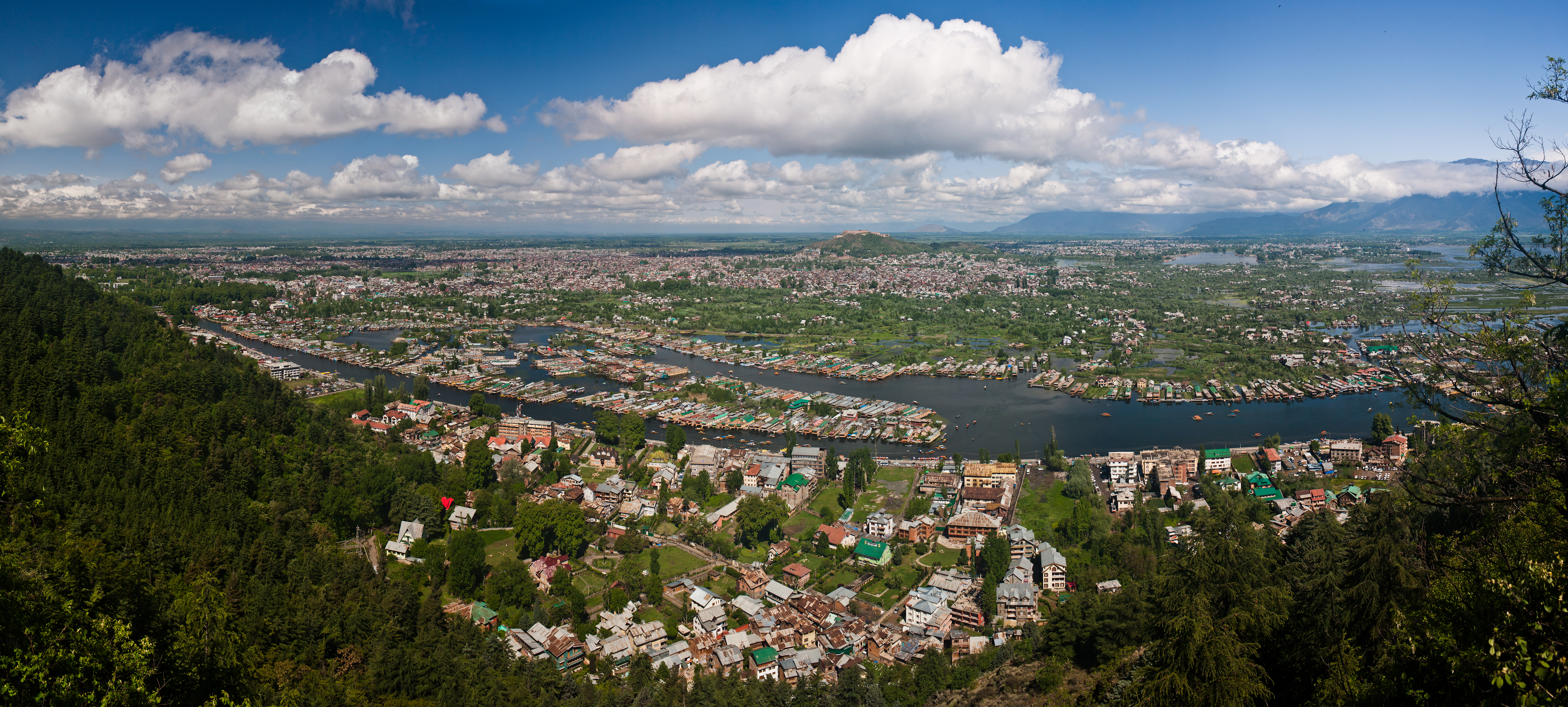
[[File:Srinagar pano.jpg|thumb|Panorama of Srinagar]] | {{Excerpt|Srinagar|Tourism|paragraphs=1,2,3,4}} Indira Gandhi Memorial Tulip garden, previously Model Floriculture Center, is a tulip garden in Srinagar. It is the largest tulip garden in Asia spread over an area of about {{convert|30|ha|acre|abbr=off}}. It is situated at the base of the Zabarwan range, built on a sloping ground in a terraced fashion consisting of seven terraces with an overview of the Dal Lake. The garden was opened in 2007 with the aim to boost floriculture and tourism in the Kashmir Valley. It was formerly known as Siraj Bagh. About 1.5 million tulip bulbs, all in multiple colours, were brought from Keukenhof tulip gardens of Amsterdam. Besides tulips, there are 46 varieties of flowers, including hyacinths, daffodils and ranunculus which were also brought from Holland. The tulip garden is home to around 68 varieties of tulips.The Tulip festival is an annual Spring festival to increase tourism by the Government of Jammu and Kashmir. The festival showcases a variety of flowers in the garden.[[File:Srinagar pano.jpg|thumb|Panorama of Srinagar]] | ||
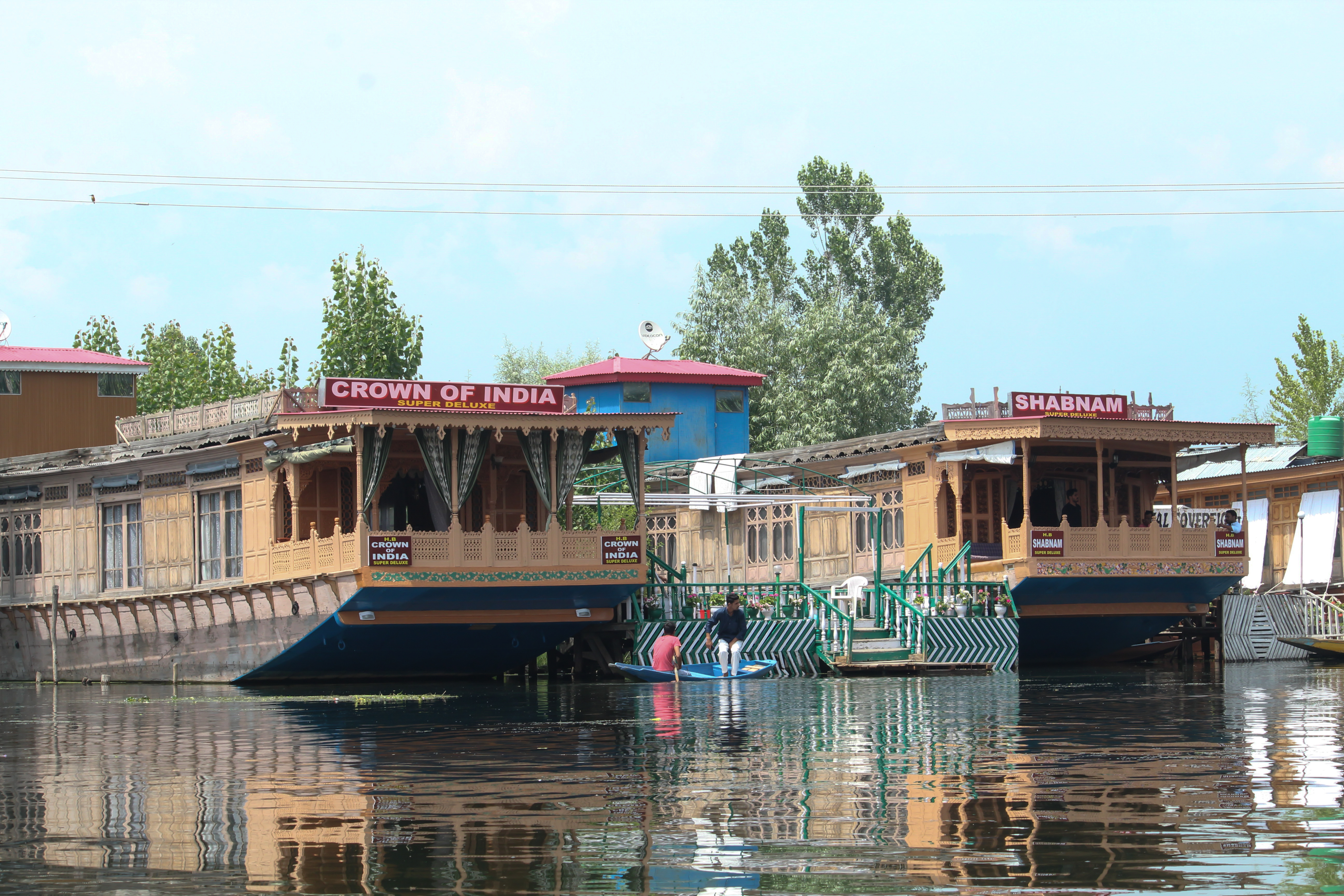
[[File: | [[File:Dal Lake, Srinagar, Jammu and Kashmir.jpg|thumb|[[Houseboat]]s on [[Dal Lake]]]] | ||
=== Verinag === | === Verinag === | ||
{{Excerpt|Verinag}} | {{Excerpt|Verinag}} | ||
==Adventure | === Gurez=== | ||
{{Excerpt|Gurez}} | |||
=== Doodhpathri=== | |||
{{Excerpt|Doodhpathri}} | |||
=== Kheer Bhawani=== | |||
{{Excerpt|Kheer Bhawani}} | |||
==Major tourist attractions in Chenab Valley== | |||
{{main|List of tourist attractions in Chenab Valley}} | |||
The [[Chenab valley]] is a region which refers to districts of [[Doda district|Doda]], [[Kishtwar district|Kishtwar]], [[Ramban district|Ramban]] and parts of [[Reasi district|Reasi]]. The major tourist attractions in this region are; | |||
*[[Bhaderwah]]. | |||
*[[Jai Valley]]. | |||
*[[Padri Pass]]. | |||
*[[Lal Draman]] | |||
*[[Bhal Padri]] | |||
*[[Sinthan Top]] | |||
*[[Chenab Rail Bridge]] | |||
==Adventure tourism== | |||
===Skiing=== | ===Skiing=== | ||
* [[Gulmarg]] | |||
* [[Patnitop]] | * [[Patnitop]] | ||
* [[Sanasar]] | * [[Sanasar]] | ||
* [[Jai Valley]]: The Jai Valley at a height of 7000 ft. located 32 | * [[Jai Valley]]: The Jai Valley at a height of 7000 ft. located 32 km from Bhaderwah, and 232 km (approx.) from Jammu is a region spread over 6 km receives ample snow to attract ski-lovers and snow-boarders.{{citation needed|date=December 2022}} | ||
===Rafting=== | ===Rafting=== | ||
* The [[Reasi]]- Dera Baba Banda Bahadur stretch of 12 | * [[Sonamarg]]- river rafting tournaments are held by tourism department. | ||
* The [[Reasi]]- Dera Baba Banda Bahadur stretch of 12 km (approx.) houses rapids up to 3rd grade and is ideal for amateurs and joy rides. | |||
===Para-gliding=== | ===Para-gliding=== | ||
* [[Sanasar]], 19 | * [[Sanasar]], 19 km west of Patnitop and 130 km from Jammu. | ||
===Camping=== | ===Camping=== | ||
* [[Sanasar]] | * [[Sanasar]] | ||
* | * [[Bani, India|Bani]]-[[Sarthal valley|Sarthal]] | ||
* [[Jai Valley]] | * [[Jai Valley]] | ||
* [[Patnitop]] | * [[Patnitop]] | ||
===Rock | |||
===Rock climbing=== | |||
* [[Patnitop]] | * [[Patnitop]] | ||
* [[Sanasar]] | * [[Sanasar]] | ||
* [[Bhaderwah]] | * [[Bhaderwah]] | ||
===Trekking=== | ===Trekking=== | ||
* [[Udhampur]] | * [[Udhampur]] | ||
| Line 56: | Line 108: | ||
* [[Bhaderwah]] | * [[Bhaderwah]] | ||
* [[Bani, India|Bani]]-[[Basholi]] | * [[Bani, India|Bani]]-[[Basholi]] | ||
* [[Sarthal valley]]<ref>http://jammutourism.gov.in/Adventure.html</ref> | * [[Sarthal valley]] | ||
*[[Sonamarg]] | |||
<ref>{{Cite web|url=http://jammutourism.gov.in/Adventure.html|title = Directorate of Tourism Jammu, J&K}}</ref> | |||
== Transport == | == Transport == | ||
[[File:Lapangan_terbang_Srinagar.jpg|thumb|View of Sheikh ul-Alam International Airport]] | [[File:Lapangan_terbang_Srinagar.jpg|thumb|View of Sheikh ul-Alam International Airport]] | ||
The primary methods of transport in Jammu and Kashmir are by road and air. It has access to the rest of India through the [[Banihal]] road tunnel near [[Qazigund]] | The primary methods of transport in Jammu and Kashmir are by road and air. It has access to the rest of India through the [[Banihal]] road tunnel near [[Qazigund]] through [[National Highway 1A (India)|NH 1A]] (now known as [[NH 44]]) and through [[National Highway 1B (India, old numbering)|NH 1B]] that passes through [[Sinthan top|Sinthan pass]] and [[Kishtwar]]. | ||
Jammu and Kashmir has 2 civil airports. The [[Jammu Airport]] and the [[Sheikh ul-Alam International Airport]] in [[Srinagar]]. They receive direct flights from [[New Delhi]], [[Mumbai]] and [[Bengaluru]]. | Jammu and Kashmir has 2 civil airports. The [[Jammu Airport]] and the [[Sheikh ul-Alam International Airport]] in [[Srinagar]]. They receive direct flights from [[New Delhi]], [[Mumbai]] and [[Bengaluru]]. | ||
Jammu and Kashmir has a {{convert|119|km|abbr=on|0}} long modern [[Jammu–Baramulla line|railway]] line that started in October 2009 and connects Baramulla in the western part of the valley to Srinagar and [[Qazigund]]. It further links the Kashmir Valley to Banihal across the Pir Panjal mountains through the new {{cvt|11.215|km}} long [[Pir Panjal Railway Tunnel]] or Banihal rail tunnel | Jammu and Kashmir has a {{convert|119|km|abbr=on|0}} long modern [[Jammu–Baramulla line|railway]] line that started in October 2009 and connects Baramulla in the western part of the valley to Srinagar and [[Qazigund]]. It further links the Kashmir Valley to Banihal across the Pir Panjal mountains through the new {{cvt|11.215|km}} long [[Pir Panjal Railway Tunnel]] or through the Banihal rail tunnel. Banihal railway station will be linked to the rest of India in another few years as the construction of the railway line from Jammu to Banihal progresses steadily. | ||
==See also== | |||
*[[List of tourist attractions in Chenab Valley]]. | |||
*[[Kashmir Conflict]] | |||
== References == | == References == | ||
{{Reflist}} | {{Reflist}} | ||
{{reflist|group=lower-alpha}} | |||
==External links== | ==External links== | ||
* [http://www.jktourism.jk.gov.in/ Official website of the Jammu and Kashmir tourism] | |||
* [http://jktdc.co.in/ Official website of J&K Tourism Development Corporation] | |||
* [http://www.jktourism. | |||
* [http://jktdc.in/ Official website of J&K Tourism Development Corporation] | |||
* [http://www.jksrtc.co.in/ Official website of J&K State Road Transport Corporation] | * [http://www.jksrtc.co.in/ Official website of J&K State Road Transport Corporation] | ||
* [https://www.travellingfolks.com/ jammu-kashmir-tourism ] | |||
{{Jammu and Kashmir topics}} | {{Jammu and Kashmir topics}} | ||
{{Tourism in India}} | {{Tourism in India}} | ||
[[Category:Tourism in Jammu and Kashmir| ]] | [[Category:Tourism in Jammu and Kashmir|*]] | ||
[[Category:Tourist attractions in Jammu and Kashmir| 01]] | [[Category:Tourist attractions in Jammu and Kashmir| 01]] | ||
[[Category:Economy of Jammu and Kashmir]] | [[Category:Economy of Jammu and Kashmir]] | ||
Latest revision as of 15:37, 28 July 2023
Jammu and Kashmir is home to several valleys such as the Kashmir Valley, Chenab Valley, Sindh Valley and Lidder Valley. Some major tourist attractions in Jammu and Kashmir are Srinagar, with its renowned Dal Lake and Mughal Gardens, Gulmarg, Pahalgam, Bhaderwah, Patnitop and Jammu. Every year, thousands of Hindu pilgrims visit holy shrines of Vaishno Devi and Amarnath which has had a significant impact on the state's economy.[1]
Kashmir Valley is one of the top tourist destinations of India.[2] Gulmarg, one of the most popular ski resort destinations in India, is also home to the world's highest green golf course.[3] Tourism has declined in the past thirty years.[4]
Jammu and Kashmir also has flower gardens and apple orchards. It attracts tourists for its handicrafts and the Kashmiri shawls.
Major attractions in North Kashmir[edit | edit source]
The first ever Map of Tourism in Jammu and Kashmir was published in "Konnect Magazine"[citation needed] and then on official Twitter handle of Jammu and Kashmir Tourism.[5] North Kashmir is located mostly in the Himalayan mountains.[6]
Bangus Valley[edit | edit source]
Between the green hills, streams, and meadows lie a valley In Jammu and Kashmir's Kupwara where the cattle run wild, birds sing lullabies through the day.[citation needed] The place is named Bangus Valley. According to a report,[clarification needed] the valley is located nearly 10,000 meters above sea level (MSL). The Bangus Valley is located in Kupwara district of North Kashmir. It is situated to the West of Handwara town along the Mawri River within the Handwara sub-district. district Kupwara. The term Bangus comes from Sanskrit word Van (Forest) and gus (grass).The valley is nearly 130 km from Srinagar and is situated on the northwestern border of Tehsil Handwara in Kupwara. Divided into two parts-Bod Bungus (Big Bungus) and Lokut Bungus (Small Bungus) the valley spans over an area of 300 km2. Bangus is about 150 kilometres (93 miles) from Srinagar at an altitude of 10,000 feet (3,000 m). The principal valley is locally known as "Boud Bangus" (Big Bangus) and has an estimated area of about 300 square kilometers. It consists of a linear elliptical bowl aligned along the east–west axis and is surrounded by Rajwar and Mawar in the east, Shamasbury and Dajlungun Mountains in the west and Chowkibal and Karnah Guli in the north. It is surrounded by the Shamsbery mountain range and the Leepa Valley, according to the report.[clarification needed] After years of planning,[citation needed] Bangus was recently[when?] made motorable via the Mawer route while work is in full swing on the Chowkibal and Rajwar routes. Its high altitude and unpredictable weather conditions were a huge obstacle but the administration has materialized this project in a short span of time. The Centre recognised 75 new destinations in the Union Territory for tourism this year.[when?] Under the Jal Jeevan Mission and 'Har Ghar Nal Say Jal Mission, the water scarcity days of Kupwara are over. The district constructed 400 Amrit Sarovar in 2022 to support the safe drinking water initiative of the government. The Kupwara District Administration and Tourism Department organized a two-day Bangus Mela earlier this year in August. The event focused on the traditions and culture of the region.[citation needed] Music artists, singers, Kashmiri Rowfdancers, and school report said.[clarification needed] children organized shows for the audience. Pony wallas also put up a special segment with the ponies displaying riding tricks and offering salami to the spectators. The festival folk songs were played nonstop which added to the upbeat atmosphere of the usually quiet valley.[citation needed]
The Lolab Bangus Drang yari Development Authority (LRDDA) installed night-stay tents for tourists. The meadows and slopes of Bungus are enveloped in flowers and medicinal plants such as Macrotima Benthami (gew zaban), Saussurea Sacra (Jugi pedshah), and Aconitum Heterophylleum (patrees). Recently[when?] a new species of flowering medicinal plant ‘Swertia Kashmirensis’ has been discovered in Bungus.[citation needed] The fauna in Bungus includes musk deer, antelope, snow leopards, brown and black bears, monkeys, and red foxes. The bird species include pheasants, tragopan, black partridge, bush quail, and wildfowl. Until two years ago,[when?] the valley was not an easy destination due to its proximity to the LoC (5 km) but the reinstallation of better security systems after the abrogation of Article 370, has helped to increase the faith of explorers who earlier did not find it safe to visit. Previously, visitors had to obtain permits from the District Magistrate to trek and camp but with the ripple effect of the political developments has been so effective that all such restrictions have now been lifted.[citation needed]
As of 2 June 2022, the road connectivity from Handwara side via Mawer is complete. People can take only small cars to Bangus because work on macdamisation is still going on. Vehicles are available on rent basis from Handwara market. Night stay tents are also available there. There are three routes to visit this place. The least distance route from Handwara via Reshwari Mawer. The second route is also from Handwara but via Rajwar and is suitable for trekking only. The third route from Kupwara via Chowkibal.
Bhadrakali Mandir[edit | edit source]
An ancient idol of Mata Bhadrakali was reinstalled at a temple in Jammu and Kashmir's Kupwara district years after it was brought back from Jammu. The ancient temple at Bhadrakali Village in Handwara wore a festive look as the original idol of the presiding deity, Maa Bhadrakali, was restored to its original abode in a simple ceremony in March 2019.[7] The idol was stolen in 1981 was subsequently recovered and kept in Jammu since 1999. It is believed that during the exodus of Pandits from Handwara, the idol was left behind in the house of Pandit Jaggernath. The nearest airport is Sheikh ul-Alam International Airport in Srinagar located 78.8 kilometers from Handwara. Handwara is not yet connected to railways. The nearest railway station is Baramulla railway station located 30 kilometers from Handwara. Handwara is well-connected with roads and highways. The NH 701 passes through Handwara alongside other intra-town roads.
Tithwal[edit | edit source]
Tithwal is a small border village about 171 km from Srinagar. After a scenic drive through Sopore, Kupwara and on to Tangdhar, one arrives at Tithwal. Another 80 km and on comes Sharda Peeth. Beyond the Sadhna top lies the Karnah valley along the river Kishan-Ganga and at the edge of it is the last village of North-West Kashmir, Tithwal. At 10600 feet, Sadhna pass[8] nested on the mighty Shamshabari mountain ranges originally known as Nastachun Pass is the only access to the Karnah, Neelam and Leepa valley. In the olden days, Tithwal was the trading hub where hundreds of shops lined up selling ghee, honey and walnut kernels. Those commodities would reach Tithwal from Karnah, Leepa and Neelam valleys. To immerse fully into the surroundings, the Forest Department of J&K, like at many other places, have built Kail and Deodar huts.[citation needed] To reach Tithwal one has to take NH1 from Airport road. After travelling for 45 km on NH1 take a right turn to Sangrama - Sopore road and then turn left onto Sopore - Kupwara road and then follow NH 701 to reach Tithwal.
Ancient Stupa Parihaspora[edit | edit source]
Paraspore or Paraspur is a small town 22 km North-West of Srinagar in the Kashmir Valley. It was built on a plateau above the Jhelum River by Lalitaditya Muktapida. Parihaspur lost its status as a capital after Lalitaditya's death. His son moved the royal residence. The Jhelum River is to the northeast of Parihaspur as it meets the Sind Nallah at Shadpur sangam. In the past this confluence of the rivers occurred closer to Parihaspur. To reach Paraspore one has to head southwest on Airport Road, make a U-turn to hit NH1. Continue straight on NH1 past M.R. Brand for 55 km and turn left onto Baramula-Gulmarg road and stay on it for 1.2 km to reach the destination.
Detha Mandir[edit | edit source]
The lord Detha temple[9] is situated in a small village about 105 km from Srinagar. To reach this temple, one must take a long drive moving from Srinagar to Pattan and onwards to Uri. The century-old map is the key to understanding the wealth of Hindu heritage and culture that Kashmir was once renowned for. One of the most noted monuments documented by many archaeologists, historians and architects is the Datta Mandir located at Banihal near Uri.[citation needed] To reach Detha Mandir one has to head Southwest on Airport Road, make a U-turn to hit NH1and drive for 3.8 km followed by a slight left onto NH1. After a drive of 15 km on NH1 past M.R. Brand, turn left after 1.2 km on to NH1. Stay on this road for 89 km until you reach Datta Temple, Uri.
Gurudwara Thara Sahib, Baramulla[edit | edit source]
Baramulla is a boulevard surrounded by breathtaking rice fields and meadows. Baramulla is about 55 km from Srinagar. This historic shrine is 8 km away from Baramulla town and 01 km on Baramulla – Srinagar National highway. According to local history, a faqir named Balol and his disciples met Guru Sahib near Kalampura village. They discussed religious discourses with Guru Ji. At the request of people, Guru Ji dug out a fresh water chisma. In the last years of 19th century, a plate form (Thara) 20 x 25 ft. was constructed by S. Matwal Singh Sahni and other Gur Sikhs. Chief Khalsa Dewan Amritsar intellectuals like Bhai Vir Singh, S. Damodar Singh Engineer, S. Narinder Singh and others also visited this place and constructed a Gurdwara in 1928-1931 A.D. The Gurdwara is managed by Gurdwara Parbandhak Committee, Baramulla. To reach Gurudwara Thara Sahib one has to Head Southwest on Airport Road, make a U-turn to hit NH1and drive for 3.8 km followed by a slight left onto NH1. After a drive of 15 km on NH1 past M.R. Brand, turn left after 1.2 km on to NH1. Continue straight for 32 km passing Zehra Crossing and then turn left onto Singhpora-Delina Road. After driving for 2.9 km, turn right onto Singhpora-Kalampora Road for 260mtrs arriving at the destination
Major attractions in South Kashmir[edit | edit source]
Gulmarg[edit | edit source]
Lua error in Module:TNT at line 159: Missing JsonConfig extension; Cannot load https://commons.wikimedia.org/wiki/Data:I18n/Module:Excerpt.tab.
Jammu[edit | edit source]
Lua error in Module:TNT at line 159: Missing JsonConfig extension; Cannot load https://commons.wikimedia.org/wiki/Data:I18n/Module:Excerpt.tab.
Pahalgam[edit | edit source]
Lua error in Module:TNT at line 159: Missing JsonConfig extension; Cannot load https://commons.wikimedia.org/wiki/Data:I18n/Module:Excerpt.tab.
Sonmarg[edit | edit source]
Srinagar[edit | edit source]
Lua error in Module:TNT at line 159: Missing JsonConfig extension; Cannot load https://commons.wikimedia.org/wiki/Data:I18n/Module:Excerpt.tab. Indira Gandhi Memorial Tulip garden, previously Model Floriculture Center, is a tulip garden in Srinagar. It is the largest tulip garden in Asia spread over an area of about 30 hectares (74 acres). It is situated at the base of the Zabarwan range, built on a sloping ground in a terraced fashion consisting of seven terraces with an overview of the Dal Lake. The garden was opened in 2007 with the aim to boost floriculture and tourism in the Kashmir Valley. It was formerly known as Siraj Bagh. About 1.5 million tulip bulbs, all in multiple colours, were brought from Keukenhof tulip gardens of Amsterdam. Besides tulips, there are 46 varieties of flowers, including hyacinths, daffodils and ranunculus which were also brought from Holland. The tulip garden is home to around 68 varieties of tulips.The Tulip festival is an annual Spring festival to increase tourism by the Government of Jammu and Kashmir. The festival showcases a variety of flowers in the garden.


Verinag[edit | edit source]
Lua error in Module:TNT at line 159: Missing JsonConfig extension; Cannot load https://commons.wikimedia.org/wiki/Data:I18n/Module:Excerpt.tab.
Gurez[edit | edit source]
Lua error in Module:TNT at line 159: Missing JsonConfig extension; Cannot load https://commons.wikimedia.org/wiki/Data:I18n/Module:Excerpt.tab.
Doodhpathri[edit | edit source]
Lua error in Module:TNT at line 159: Missing JsonConfig extension; Cannot load https://commons.wikimedia.org/wiki/Data:I18n/Module:Excerpt.tab.
Kheer Bhawani[edit | edit source]
Lua error in Module:TNT at line 159: Missing JsonConfig extension; Cannot load https://commons.wikimedia.org/wiki/Data:I18n/Module:Excerpt.tab.
Major tourist attractions in Chenab Valley[edit | edit source]
The Chenab valley is a region which refers to districts of Doda, Kishtwar, Ramban and parts of Reasi. The major tourist attractions in this region are;
Adventure tourism[edit | edit source]
Skiing[edit | edit source]
- Gulmarg
- Patnitop
- Sanasar
- Jai Valley: The Jai Valley at a height of 7000 ft. located 32 km from Bhaderwah, and 232 km (approx.) from Jammu is a region spread over 6 km receives ample snow to attract ski-lovers and snow-boarders.[citation needed]
Rafting[edit | edit source]
- Sonamarg- river rafting tournaments are held by tourism department.
- The Reasi- Dera Baba Banda Bahadur stretch of 12 km (approx.) houses rapids up to 3rd grade and is ideal for amateurs and joy rides.
Para-gliding[edit | edit source]
- Sanasar, 19 km west of Patnitop and 130 km from Jammu.
Camping[edit | edit source]
Rock climbing[edit | edit source]
Trekking[edit | edit source]
Transport[edit | edit source]

The primary methods of transport in Jammu and Kashmir are by road and air. It has access to the rest of India through the Banihal road tunnel near Qazigund through NH 1A (now known as NH 44) and through NH 1B that passes through Sinthan pass and Kishtwar.
Jammu and Kashmir has 2 civil airports. The Jammu Airport and the Sheikh ul-Alam International Airport in Srinagar. They receive direct flights from New Delhi, Mumbai and Bengaluru.
Jammu and Kashmir has a 119 km (74 mi) long modern railway line that started in October 2009 and connects Baramulla in the western part of the valley to Srinagar and Qazigund. It further links the Kashmir Valley to Banihal across the Pir Panjal mountains through the new 11.215 km (6.969 mi) long Pir Panjal Railway Tunnel or through the Banihal rail tunnel. Banihal railway station will be linked to the rest of India in another few years as the construction of the railway line from Jammu to Banihal progresses steadily.
See also[edit | edit source]
References[edit | edit source]
- ↑ "Amarnath Board to study yatra impact on Kashmir economy". Online edition of The Hindu. Chennai, India. 13 September 2007. Archived from the original on 9 November 2012. Retrieved 6 June 2009.
- ↑ "Foreign tourists flock Kashmir". Online edition of The Hindu. Chennai, India. 18 March 2009. Archived from the original on 9 November 2012. Retrieved 18 March 2009.
- ↑ Cris Prystay (26 October 2007). "Fairway to Heaven". The Wall Street Journal.
- ↑ "Tourists arrival gives boost to J-K economy". Sify. Archived from the original on 16 July 2011.
- ↑ @jandktourism (18 October 2022). "How many places have you visited?" (Tweet). Archived from the original on 11 December 2022. Retrieved 25 May 2023 – via Twitter.
- ↑ KNO. "Tourists throng LoC villages in north Kashmir". Greater Kashmir. Retrieved 26 October 2022.
- ↑ "Ancient idol of Maa Bhadrakali installed in Kupwara temple after 38 years". Business Standard India. Press Trust of India. 20 March 2018. Retrieved 26 October 2022.
- ↑ "Sadhna Pass View Point | District Kupwara, Government of Jammu & Kashmir | India". Retrieved 14 November 2022.
- ↑ "Detha / Daata Temple".
- ↑ "Directorate of Tourism Jammu, J&K".
External links[edit | edit source]
- Official website of the Jammu and Kashmir tourism
- Official website of J&K Tourism Development Corporation
- Official website of J&K State Road Transport Corporation
- jammu-kashmir-tourism


