.svg)
Jalshara: Difference between revisions
>Chandan Guha (Removed stub tag) |
m (robot: Update article (please report if you notice any mistake or error in this edit)) |
||
| Line 55: | Line 55: | ||
| footnotes = | | footnotes = | ||
}} | }} | ||
'''Jalshara''' is a village in the [[Ghatal (community development block)|Ghatal]] [[Community development blocks in India|CD block]] in the [[Ghatal subdivision]] of the [[Paschim Medinipur district]] in the state of [[West Bengal]], [[India]]. | '''Jalshara''' is a village in the [[Ghatal (community development block)|Ghatal]] [[Community development blocks in India|CD block]] in the [[Ghatal subdivision]] of the [[Paschim Medinipur district]] in the state of [[West Bengal]], [[India]]. | ||
==Geography== | ==Geography== | ||
| Line 77: | Line 77: | ||
|mark-coord15={{coord|22|31|23|N|87|44|24|E}}| label-pos15=left|label15= Gobindanagar| numbered15=H| mark-title15= [[Gobindanagar]] (H) |shape-color15=#AA6666 | |mark-coord15={{coord|22|31|23|N|87|44|24|E}}| label-pos15=left|label15= Gobindanagar| numbered15=H| mark-title15= [[Gobindanagar]] (H) |shape-color15=#AA6666 | ||
|mark-coord16={{coord|22|39|6|N|87|38|44|E}}| label-pos16=right|label16= Iswarpur| numbered16=H| mark-title16= [[Iswarpur]] (H) |shape-color16=#AA6666 | |mark-coord16={{coord|22|39|6|N|87|38|44|E}}| label-pos16=right|label16= Iswarpur| numbered16=H| mark-title16= [[Iswarpur]] (H) |shape-color16=#AA6666 | ||
|mark-coord17={{coord|22|50|53|N|87|39|50|E}}| label-pos17=right|label17=Jalshara| numbered17=H| mark-title17= | |mark-coord17={{coord|22|50|53|N|87|39|50|E}}| label-pos17=right|label17=Jalshara| numbered17=H| mark-title17= Jalshara (H) |shape-color17=black| label-size17=13|label-color17=black <!-- make the subject of the article stand out with black colors --> | ||
|mark-coord18={{coord|22|44|30|N|87|32|24|E}}| label-pos18=right|label18=Jayantipur| numbered18=H| mark-title18= [[Jayantipur]] (H) |shape-color18=#AA6666 | |mark-coord18={{coord|22|44|30|N|87|32|24|E}}| label-pos18=right|label18=Jayantipur| numbered18=H| mark-title18= [[Jayantipur]] (H) |shape-color18=#AA6666 | ||
|mark-coord19={{coord|22|37|42|N|87|44|47|E}}| label-pos19=left|label19=Kotalpur| numbered19=H| mark-title19= [[Kotalpur]] (H) |shape-color19=#AA6666 | |mark-coord19={{coord|22|37|42|N|87|44|47|E}}| label-pos19=left|label19=Kotalpur| numbered19=H| mark-title19= [[Kotalpur]] (H) |shape-color19=#AA6666 | ||
| Line 88: | Line 88: | ||
|mark-coord26={{coord|22|33|50|N|87|49|12|E}}| label-pos26=right|label26=Uttar Bar| numbered26=H| mark-title26= [[Uttar Bar]] (H) |shape-color26=#AA6666 | |mark-coord26={{coord|22|33|50|N|87|49|12|E}}| label-pos26=right|label26=Uttar Bar| numbered26=H| mark-title26= [[Uttar Bar]] (H) |shape-color26=#AA6666 | ||
|mark-coord27={{coord|22|42|21|N|87|47|0|E}}| label27=Rupnarayan River| label-color27 = #77A1CB| label-angle27=65| label-pos27=right| label-size27=10| mark-size27=0| mark-title27=none}} | |mark-coord27={{coord|22|42|21|N|87|47|0|E}}| label27=Rupnarayan River| label-color27 = #77A1CB| label-angle27=65| label-pos27=right| label-size27=10| mark-size27=0| mark-title27=none}} | ||
===Area overview=== | ===Area overview=== | ||
[[Ishwar Chandra Vidyasagar]], scholar, social reformer and a key figure of the [[Bengal Renaissance]], was born at [[Birsingha]] on 26 September 1820.<ref>{{cite web |url= http://en.banglapedia.org/index.php?title=Vidyasagar,_Ishwar_Chandra |title= Vidyasagar, Pundit Iswar Chandra |publisher=Banglapedia |access-date=24 July 2016 |last=Murshid |first=Ghulam}}</ref><ref>{{cite web |url=http://www.whereincity.com/india/great-indians/literary-persons/ishwar-chandra.php |title=Ishwar Chandra Vidyasagar |publisher=www.whereincity.com |access-date=24 July 2016 }}</ref> | [[Ishwar Chandra Vidyasagar]], scholar, social reformer and a key figure of the [[Bengal Renaissance]], was born at [[Birsingha]] on 26 September 1820.<ref>{{cite web |url= http://en.banglapedia.org/index.php?title=Vidyasagar,_Ishwar_Chandra |title= Vidyasagar, Pundit Iswar Chandra |publisher=Banglapedia |access-date=24 July 2016 |last=Murshid |first=Ghulam}}</ref><ref>{{cite web |url=http://www.whereincity.com/india/great-indians/literary-persons/ishwar-chandra.php |title=Ishwar Chandra Vidyasagar |publisher=www.whereincity.com |access-date=24 July 2016 }}</ref> | ||
Ghatal subdivision, shown in the map alongside, has [[Alluvium|alluvial]] soils. Around 85% of the total cultivated area is cropped more than once.<ref>{{cite web | url = http://www.wbpspm.gov.in/publications/District%20Human%20Development%20Report| title = District Human Development Report Paschim Medinipur, 2011| work= | pages= | Ghatal subdivision, shown in the map alongside, has [[Alluvium|alluvial]] soils. Around 85% of the total cultivated area is cropped more than once.<ref>{{cite web | url = http://www.wbpspm.gov.in/publications/District%20Human%20Development%20Report| title = District Human Development Report Paschim Medinipur, 2011| work= | pages= 27–28| publisher = Department of Planning and Statistics, Government of West Bengal |access-date = 10 September 2020}}</ref> It has a density of population of 1,099 per km<sup>2</sup>, but being a small subdivision only a little over a fifth of the people in the district reside in this subdivision. 14.33% of the population lives in urban areas and 86.67% lives in the rural areas.<ref>{{cite web | url = http://www.wbpspm.gov.in/publications/District%20Statistical%20Handbook | title = District Statistical Handbook Paschim Medinipur, 2013| work= Table 2.2, 2.4 (a)| publisher = Department of Planning and Statistics |access-date = 10 September 2020}}</ref> | ||
<small>Note: The map alongside presents some of the notable locations in the subdivision. All places marked in the map are linked in the larger full screen map.</small> | <small>Note: The map alongside presents some of the notable locations in the subdivision. All places marked in the map are linked in the larger full screen map.</small> | ||
| Line 111: | Line 110: | ||
File:Baro Chala temple of Buro Shiva at Jalsara under Ghatal Police Station in Paschim Medinipur district in West Bengal 04.jpg|Buro Shiva temple | File:Baro Chala temple of Buro Shiva at Jalsara under Ghatal Police Station in Paschim Medinipur district in West Bengal 04.jpg|Buro Shiva temple | ||
</gallery> | </gallery> | ||
==References== | ==References== | ||
Latest revision as of 08:09, 27 September 2021
Jalshara | |
|---|---|
Village | |
 Jalshara Location in West Bengal, India  Jalshara Jalshara (India) | |
| Coordinates: 22°40′54″N 87°39′51″E / 22.681634°N 87.664091°ECoordinates: 22°40′54″N 87°39′51″E / 22.681634°N 87.664091°E | |
| Country | |
| State | West Bengal |
| District | Paschim Medinipur |
| Population (2011) | |
| • Total | 2,183 |
| Languages | |
| • Official | Bengali, English |
| Time zone | UTC+5:30 (IST) |
| PIN | 721212 |
| Telephone/STD code | 03225 |
| Lok Sabha constituency | Ghatal |
| Vidhan Sabha constituency | Ghatal |
| Website | paschimmedinipur |
Jalshara is a village in the Ghatal CD block in the Ghatal subdivision of the Paschim Medinipur district in the state of West Bengal, India.
Geography[edit]
| Cities and towns in Ghatal subdivision of Paschim Medinipur district M: municipal city/ town, R: rural/ urban centre, H: historical/ religious centre Owing to space constraints in the small map, the actual locations in a larger map may vary slightly |
Area overview[edit]
Ishwar Chandra Vidyasagar, scholar, social reformer and a key figure of the Bengal Renaissance, was born at Birsingha on 26 September 1820.[1][2]
Ghatal subdivision, shown in the map alongside, has alluvial soils. Around 85% of the total cultivated area is cropped more than once.[3] It has a density of population of 1,099 per km2, but being a small subdivision only a little over a fifth of the people in the district reside in this subdivision. 14.33% of the population lives in urban areas and 86.67% lives in the rural areas.[4]
Note: The map alongside presents some of the notable locations in the subdivision. All places marked in the map are linked in the larger full screen map.
Demographics[edit]
According to the 2011 Census of India, Jalshara had a total population of 2,183, of which 1,118 (51%) were males and 1,065 (49%) were females. There were 252 persons in the age range of 0–6 years. The total number of literate persons in Jalshhara was 1,378 (71.36% of the population over 6 years).[5]
Education[edit]
Jalshara R.K.High School is a Bengali-medium coeducational institution established in 1960. The school has facilities for teaching from class V to class XII. It has a library with 135 books, 9 computers and a playground.[6]
Culture[edit]
David J. McCutchion mentions the Siva temple at Jalshara as a high-towered baro-chala with ratha projections. It is largely plain and measures 13’ square.[7]
Jalshara picture gallery[edit]
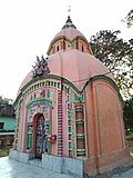
Baro-chala Buro Shiva temple

Buro Shiva temple


References[edit]
- ↑ Murshid, Ghulam. "Vidyasagar, Pundit Iswar Chandra". Banglapedia. Retrieved 24 July 2016.
- ↑ "Ishwar Chandra Vidyasagar". www.whereincity.com. Retrieved 24 July 2016.
- ↑ "District Human Development Report Paschim Medinipur, 2011". Department of Planning and Statistics, Government of West Bengal. pp. 27–28. Retrieved 10 September 2020.
- ↑ "District Statistical Handbook Paschim Medinipur, 2013". Table 2.2, 2.4 (a). Department of Planning and Statistics. Retrieved 10 September 2020.
- ↑ "CD block Wise Primary Census Abstract Data(PCA)". West Bengal – District-wise CD blocks. Registrar General and Census, India. Retrieved 25 August 2020.
- ↑ "Jalshar R.K. High School U. Pry". Schools.org. Retrieved 25 August 2020.
- ↑ McCutchion, David J., Late Mediaeval Temples of Bengal, first published 1972, reprinted 2017, page 40. The Asiatic Society, Kolkata, ISBN 978-93-81574-65-2