


Created page with "{{About|Town in Leh|its namesake district|Leh district|other uses}} {{Lead too short|date=July 2021}} {{Use dmy dates|date=March 2013}} {{Use Indian English|date=June 2013}} {..." |
Added content |
||
| Line 1: | Line 1: | ||
{{About| | {{About|the town|its namesake district|Leh district|other uses}} | ||
{{Lead too short|date=July 2021}} | {{Lead too short|date=July 2021}} | ||
{{Use dmy dates|date=March 2013}} | {{Use dmy dates|date=March 2013}} | ||
| Line 28: | Line 28: | ||
| coordinates = {{coord|34.16|77.58|display=inline,title}} | | coordinates = {{coord|34.16|77.58|display=inline,title}} | ||
| subdivision_type = [[List of sovereign states|Country]] | | subdivision_type = [[List of sovereign states|Country]] | ||
| subdivision_name = {{ | | subdivision_name = {{IND}} | ||
| subdivision_type1 = [[States and union territories of India|Union Territory]] | | subdivision_type1 = [[States and union territories of India|Union Territory]] | ||
| subdivision_type2 = [[List of districts of Ladakh|District]] | | subdivision_type2 = [[List of districts of Ladakh|District]] | ||
| subdivision_type3 = | | subdivision_type3 = | ||
| subdivision_name1 = {{flagicon image|Ladakh Government Banner.png}} [[Ladakh]] | | subdivision_name1 = {{flagicon image|Ladakh Government Banner.png}} [[Ladakh]] | ||
| subdivision_name2 = [[Leh district|Leh]] | | subdivision_name2 = [[Leh district|Leh]] | ||
| subdivision_name3 = | | subdivision_name3 = | ||
| Line 45: | Line 45: | ||
| area_rank = | | area_rank = | ||
| elevation_footnotes = | | elevation_footnotes = | ||
| elevation_m = | | elevation_m = 3500 | ||
| population_total = 30870 | | population_total = 30870 | ||
| population_as_of = 2011 | | population_as_of = 2011 | ||
| Line 59: | Line 59: | ||
| postal_code_type = <!-- [[Postal Index Number|PIN]] --> | | postal_code_type = <!-- [[Postal Index Number|PIN]] --> | ||
| postal_code = | | postal_code = | ||
| registration_plate = LA | | registration_plate = LA 02 | ||
| website = {{url|leh.nic.in}} | | website = {{url|leh.nic.in}} | ||
| footnotes = | | footnotes = | ||
| Line 65: | Line 65: | ||
}} | }} | ||
'''Leh''' ({{IPAc-en|'|l|eɪ | '''Leh''' ({{IPAc-en|'|l|eɪ}}) is the joint capital and largest town of the [[union territory]] of [[Ladakh]] in [[India]]. Leh, located in the [[Leh district]], was also the historical capital of the Kingdom of Ladakh, the seat of which was in the [[Leh Palace]], the former residence of the royal family of Ladakh, built in the same style and about the same time as the [[Potala Palace]] in [[Tibet]]. Leh is at an altitude of {{cvt|3524|m}}, and is connected via [[National Highway 1 (India)|National Highway 1]] to [[Srinagar]] in the southwest and to [[Manali, Himachal Pradesh|Manali]] in the south via the [[Leh-Manali Highway]]. | ||
==History== | ==History== | ||
[[File:Beautiful Leh Couple In Traditional Dress (202673443).jpeg|thumb | [[File:Beautiful Leh Couple In Traditional Dress (202673443).jpeg|thumb|People of Leh with traditional dress]] | ||
Leh was an important stopover on trade routes along the [[Indus | Leh was an important stopover on trade routes along the [[Indus Valley]] between [[Tibet]] to the east, [[Kashmir]] to the west and also between India and China for centuries. The main goods carried were salt, grain, ''pashm'' or [[cashmere wool]], ''[[charas]]'' or [[cannabis (drug)|cannabis]] resin from the [[Tarim Basin]], [[indigo]], silk yarn and [[Banaras]] [[brocade]]. | ||
Although there are a few indications that the Chinese knew of a trade route through Ladakh to India as early as the [[Kushan]] period (1st to 3rd centuries CE),<ref>Hill (2009), pp. 200-204.</ref> and certainly by [[Tang dynasty]],<ref>Francke (1977 edition), pp. 76-78</ref> little is actually known of the history of the region before the formation of the kingdom towards the end of the 10th century by the Tibetan prince, ''Skyid lde nyima gon'' (or ''Nyima gon''), a grandson of the anti-Buddhist Tibetan king, [[Langdarma]] (r. c. 838 to 841). He conquered Western Tibet although his army originally numbered only 300 men. Several towns and castles are said to have been founded by Nyima gon and he apparently ordered the construction of the main sculptures at [[Shey]]. "In an inscription, he says he had them made for the religious benefit of the ''Tsanpo'' (the dynastical name of his father and ancestors), and of all the people of ''Ngaris'' (Western Tibet). This shows that already in this generation Langdarma's opposition to Buddhism had disappeared."<ref>Francke (1914), pp. 89-90.</ref> Shey, just 15 km east of modern Leh, was the ancient seat of the Ladakhi kings. | Although there are a few indications that the Chinese knew of a trade route through Ladakh to India as early as the [[Kushan]] period (1st to 3rd centuries CE),<ref>Hill (2009), pp. 200-204.</ref> and certainly by [[Tang dynasty]],<ref>Francke (1977 edition), pp. 76-78</ref> little is actually known of the history of the region before the formation of the kingdom towards the end of the 10th century by the Tibetan prince, ''Skyid lde nyima gon'' (or ''Nyima gon''), a grandson of the anti-Buddhist Tibetan king, [[Langdarma]] (r. c. 838 to 841). He conquered Western Tibet although his army originally numbered only 300 men. Several towns and castles are said to have been founded by Nyima gon and he apparently ordered the construction of the main sculptures at [[Shey]]. "In an inscription, he says he had them made for the religious benefit of the ''Tsanpo'' (the dynastical name of his father and ancestors), and of all the people of ''Ngaris'' (Western Tibet). This shows that already in this generation Langdarma's opposition to Buddhism had disappeared."<ref>Francke (1914), pp. 89-90.</ref> Shey, just 15 km east of modern Leh, was the ancient seat of the Ladakhi kings. | ||
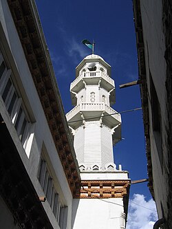
During the reign of Delegs Namgyal (1660–1685),<ref>Francke (1977 edition), p. 20.</ref> the [[Nawab]] of Kashmir, which was then a province in the Mughal Empire, arranged for the Mongol army to temporarily leave Ladakh, though it returned later. As payment for assisting Delegs Namgyal in the Tibet-Ladakh-Mughal war of 1679–1684, the Nawab made a number of onerous demands. One of the least was to build a large [[Sunni Muslim]] mosque in Leh at the upper end of the bazaar in Leh, below the Leh Palace. The mosque reflects a mixture of [[Islamic]] and | During the reign of Delegs Namgyal (1660–1685),<ref>Francke (1977 edition), p. 20.</ref> the [[Nawab]] of Kashmir, which was then a province in the Mughal Empire, arranged for the Mongol army to temporarily leave Ladakh, though it returned later. As payment for assisting Delegs Namgyal in the Tibet-Ladakh-Mughal war of 1679–1684, the Nawab made a number of onerous demands. One of the least was to build a large [[Sunni Muslim]] mosque in Leh at the upper end of the bazaar in Leh, below the Leh Palace. The mosque reflects a mixture of [[Islamic]] and Tibetan architecture and can accommodate more than 500 people. This was apparently not the first mosque in Leh; there are two smaller ones which are said to be older.<ref>Francke (1977 edition), pp. 120-123.</ref> | ||
Several trade routes have traditionally converged on Leh, from all four directions. The most direct route was the one the modern highway follows from the [[Punjab region|Punjab]] via [[Mandi, Himachal Pradesh, India|Mandi]], the [[Kulu valley]], over the [[Rohtang Pass]], through [[Lahaul]] and on to the | Several trade routes have traditionally converged on Leh, from all four directions. The most direct route was the one the modern highway follows from the [[Punjab region|Punjab]] via [[Mandi, Himachal Pradesh, India|Mandi]], the [[Kulu valley]], over the [[Rohtang Pass]], through [[Lahaul]] and on to the Indus Valley, and then downriver to Leh. The route from Srinagar was roughly the same as the road that today crosses the ''Zoji La'' (pass) to [[Kargil town|Kargil]], and then up the Indus Valley to Leh. From [[Baltistan]] there were two difficult routes: the main on ran up the Shyok Valley from the Indus, over a pass and then down the Hanu River to the Indus again below [[Khalsi, Leh|Khalsi]] (Khalatse). The other ran from [[Skardu]] straight up the Indus to Kargil and on to Leh. Then, there were both the summer and winter routes from Leh to [[Yarkant County|Yarkand]] via the [[Karakoram Pass]] and [[Xaidulla]]. Finally, there were a couple of possible routes from Leh to Lhasa.<ref>Rizvi (1996), pp. 109-111.</ref> | ||
The first recorded royal residence in Ladakh, built at the top of the high Namgyal ('Victory') Peak overlooking the present palace and town, is the now-ruined fort and the ''gon-khang'' (Temple of the Guardian Divinities) built by King Tashi Namgyal. Tashi Namgyal is known to have ruled during the final quarter of the 16th century CE.<ref>Rizvi (1996), p. 64.</ref> The Namgyal (also called "Tsemo Gompa" = 'Red Gompa', or ''dGon-pa-so-ma'' = 'New Monastery'),<ref name="Francke 1914, p. 70">Francke (1914), p. 70.</ref> a temple, is the main Buddhist centre in Leh.<ref>Rizvi (1996), pp. 41, 64, 225-226.</ref> There are some older walls of fortifications behind it which Francke reported used to be known as the "Dard Castle." If it was indeed built by [[Dards]], it must pre-date the establishment of Tibetan rulers in Ladakh over a thousand years ago.<ref>Rizvi (1996), pp. 226-227.</ref> | The first recorded royal residence in Ladakh, built at the top of the high Namgyal ('Victory') Peak overlooking the present palace and town, is the now-ruined fort and the ''gon-khang'' (Temple of the Guardian Divinities) built by King Tashi Namgyal. Tashi Namgyal is known to have ruled during the final quarter of the 16th century CE.<ref>Rizvi (1996), p. 64.</ref> The Namgyal (also called "Tsemo Gompa" = 'Red Gompa', or ''dGon-pa-so-ma'' = 'New Monastery'),<ref name="Francke 1914, p. 70">Francke (1914), p. 70.</ref> a temple, is the main Buddhist centre in Leh.<ref>Rizvi (1996), pp. 41, 64, 225-226.</ref> There are some older walls of fortifications behind it which Francke reported used to be known as the "Dard Castle." If it was indeed built by [[Dards]], it must pre-date the establishment of Tibetan rulers in Ladakh over a thousand years ago.<ref>Rizvi (1996), pp. 226-227.</ref> | ||
<blockquote>The Sankar Labrang (Bsam dkar bla brang) is a small, two-storeyed building owned by Sankar monastery. Sankar monastery is the seat of Bakula Rinpoche, immediately to the northwest of Leh. The | <blockquote>The Sankar Labrang (Bsam dkar bla brang) is a small, two-storeyed building owned by Sankar monastery. Sankar monastery is the seat of Bakula Rinpoche, immediately to the northwest of Leh. The monastery's Labrang building is located in the old town of Leh, in the Manikhang neighbourhood. Manikhang is the area between the main bazaar of Leh and the historic Stalam path that leads up to the royal palace. Four huge ''stūpas'' standing at this point mark the beginning of historic Leh. In recent memory, the Sankar Labrang had a metalsmith's workshop downstairs, while upstairs lived the monk caretaker of the White Maitreya Temple (Byams khang dkar po), also known locally as "Street Maitreya". The White Maitreya Temple dates back to the reign of King Drakpa Bumd´e (Grags pa 'bum lde, r. ca 1410–1435), following the arrival of a mission sent to Ladakh by the Tibetan lama [[Tsongkhapa]].<ref>Alexander, André, and Van Shaik, Sam. (2011). ''The Stone Maitreya of Leh: The Rediscovery and Recovery of an Early Tibetan Monument.''. ''JRAS, Series 3, 21,'' 4(2011), p. 421.</ref></blockquote> | ||
Below this are the Chamba (Byams-pa, ''i.e.'', [[Maitreya]]) and Chenresi (sPyan-ras-gzigs, i.e. [[Avalokiteshvara]]) monasteries which are of uncertain date.<ref name="Francke 1914, p. 70"/> | Below this are the Chamba (Byams-pa, ''i.e.'', [[Maitreya]]) and Chenresi (sPyan-ras-gzigs, i.e. [[Avalokiteshvara]]) monasteries which are of uncertain date.<ref name="Francke 1914, p. 70"/> | ||
===Leh Palace=== | ===Leh Palace=== | ||
The '''royal palace''', known as [[Leh Palace]], was built by King [[Sengge Namgyal]] (1612–1642), presumably between the period when the Portuguese [[Jesuit]] priest, Francisco de Azevedo, visited Leh in 1631, and made no mention of it, and [[Sengge Namgyal|Sengge Namgyal's]] death in 1642.<ref>Rizvi (1996), pp. 69, 290.</ref> | [[file:Old palace, Leh.jpg|thumb|Old palace of the kings in Leh]] | ||
The '''royal palace''', known as [[Leh Palace]], was built by King [[Sengge Namgyal]] (1612–1642),<ref>{{Cite web|title=Incredible India {{!}} Leh Palace|url=https://www.incredibleindia.org/content/incredible-india-v2/en/destinations/leh-ladakh/leh-palace.html|access-date=2021-10-16|website=www.incredibleindia.org}}</ref> presumably between the period when the Portuguese [[Jesuit]] priest, Francisco de Azevedo, visited Leh in 1631, and made no mention of it, and [[Sengge Namgyal|Sengge Namgyal's]] death in 1642.<ref>Rizvi (1996), pp. 69, 290.</ref> | |||
The Leh Palace is nine storeys high; the upper floors accommodated the royal family, and the stables and storerooms are located on the lower floors. The palace was abandoned when [[Kashmiri people|Kashmiri]] forces besieged it in the mid-19th century. The royal family moved their premises south to their current home in [[Stok]] Palace on the southern bank of the | The Leh Palace is nine storeys high; the upper floors accommodated the royal family, and the stables and storerooms are located on the lower floors. The palace was abandoned when [[Kashmiri people|Kashmiri]] forces besieged it in the mid-19th century. The royal family moved their premises south to their current home in [[Stok]] Palace on the southern bank of the Indus River. | ||
: | :As has already been mentioned, the original name of the town is not ''sLel'', as it is nowadays spelled, but ''sLes'', which signifies an encampment of nomads. These [Tibetan] nomads were probably in the habit of visiting the Leh valley at a time when it had begun to be irrigated by Dard colonisers. Thus, the most ancient part of the ruins on the top of rNam-rgyal-rtse-mo hill at Leh are called 'aBrog-pal-mkhar (Dard castle).<ref>Francke (1914), p. 68. See also, ibid, p. 45.</ref> | ||
In [[2010 Leh floods|2010, Leh]] was heavily damaged by the sudden floods caused by a [[cloud burst]]. | In [[2010 Leh floods|2010, Leh]] was heavily damaged by the sudden floods caused by a [[cloud burst]]. | ||
==Administration== | ==Administration== | ||
Unlike other districts in India, the [[Ladakh Autonomous Hill Development Council, Leh|Ladakh Autonomous Hill Development Council]] (LAHDC) is in charge of governance in Leh | Unlike other districts in India, the [[Ladakh Autonomous Hill Development Council, Leh|Ladakh Autonomous Hill Development Council]] (LAHDC) is in charge of governance in Leh. | ||
It has 30 councillors, 4 nominated and 26 elected. The Chief Executive Councillor heads and chairs this council. | |||
. The 'Deputy Commissioner, Leh' also holds the power of 'Chief Executive Officer of the LAHDC'. The Current Deputy Commissioner of Leh district is Sachin Kumar Vaishya. | . The 'Deputy Commissioner, Leh' also holds the power of 'Chief Executive Officer of the LAHDC'. The Current Deputy Commissioner of Leh district is Sachin Kumar Vaishya. | ||
{{wide image|Indus Valley near Leh.jpg|1250px|The Indus River in Leh|center}} | |||
== The Old Town of Leh == | == The Old Town of Leh == | ||
[[File:Lehpalace5.jpg|thumb| | [[File:Lehpalace5.jpg|thumb|300px|Leh City View from [[Namgyal Tsemo Monastery]] along with [[Leh Palace]]]] | ||
[[Old Town and Main Bazaar, Leh|The old town of Leh]] was added to the [[World Monuments Fund]]'s list of 100 most endangered sites due to increased rainfall from climate change and other reasons.<ref>{{cite news | [[Old Town and Main Bazaar, Leh|The old town of Leh]] was added to the [[World Monuments Fund]]'s list of 100 most endangered sites due to increased rainfall from climate change and other reasons.<ref>{{cite news | ||
|url=http://news.sawf.org/Travel/41309.aspx | |url=http://news.sawf.org/Travel/41309.aspx | ||
| Line 113: | Line 116: | ||
}}</ref> | }}</ref> | ||
The rapid and poorly planned urbanisation of Leh has increased the risk of flash floods in some areas, while other areas, according to research by the [[Climate and Development Knowledge Network]], suffer from the less dramatic, gradual effects of | The rapid and poorly planned urbanisation of Leh has increased the risk of flash floods in some areas, while other areas, according to research by the [[Climate and Development Knowledge Network]], suffer from the less dramatic, gradual effects of 'invisible disasters', which often go unreported.<ref>[http://cdkn.org/2014/06/harmonising-climate-adaptation-and-disaster-risk-reduction-india Local approaches to harmonising [[climate change adaptation|climate adaptation]] and disaster risk reduction: Lessons from India, Anshu Sharma, Sahba Chauhan and Sunny Kumar, the Climate and Development Knowledge Network, 2014] cdkn.org</ref> | ||
==Geography== | ==Geography== | ||
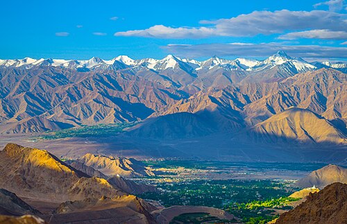
[[File:Leh overview.jpg|thumb| | [[File:Leh overview.jpg|thumb|300px|Leh and its surroundings]] | ||
The city is located on the bank of the | The city is located on the bank of the Indus. The mountains dominate the landscape around the Leh as it is at an altitude of 3,500m. Peaks, such as [[Nanga Sago]], can reach well above 5,500m. The principal access roads include the 434 km [[Srinagar]]-Leh highway which connects Leh with Srinagar and the 428 km [[Leh-Manali Highway]] which connects Manali with Leh. Both roads are open only on a seasonal basis.<ref>[http://www.jktourism.org/cities/ladakh/getting/index.htm The Journey from Kashmir]</ref> Although the access roads from Srinagar and Manali are often blocked by snow in winter, the local roads in the Indus Valley usually remain open due to the low level of precipitation and snowfall. | ||
| Line 125: | Line 128: | ||
Average annual rainfall is only 102 mm (4.02 inches). In 2010 the city experienced [[2010 Leh floods|flash floods]] which killed more than 100 people.<ref name="nyt20100806">{{cite web|url=https://www.nytimes.com/2010/08/07/world/asia/07kashmir.html|title=Mudslides Kill 125 in Kashmir|last=Polgreen|first=Lydia|date=6 August 2010|work=[[The New York Times]]|access-date=6 August 2010}}</ref> | Average annual rainfall is only 102 mm (4.02 inches). In 2010 the city experienced [[2010 Leh floods|flash floods]] which killed more than 100 people.<ref name="nyt20100806">{{cite web|url=https://www.nytimes.com/2010/08/07/world/asia/07kashmir.html|title=Mudslides Kill 125 in Kashmir|last=Polgreen|first=Lydia|date=6 August 2010|work=[[The New York Times]]|access-date=6 August 2010}}</ref> | ||
{{Leh | {{Weather box | ||
|location = Leh (1951–1980) | |||
|metric first = Yes | |||
|single line = Yes | |||
|Jan record high C = 8.3 | |||
|Feb record high C = 12.8 | |||
|Mar record high C = 19.4 | |||
|Apr record high C = 23.9 | |||
|May record high C = 28.9 | |||
|Jun record high C = 34.8 | |||
|Jul record high C = 34.0 | |||
|Aug record high C = 34.2 | |||
|Sep record high C = 30.6 | |||
|Oct record high C = 25.6 | |||
|Nov record high C = 20.0 | |||
|Dec record high C = 12.8 | |||
|year record high C = 34.8 | |||
|Jan high C = -2.0 | |||
|Feb high C = 1.5 | |||
|Mar high C = 6.5 | |||
|Apr high C = 12.3 | |||
|May high C = 16.2 | |||
|Jun high C = 21.8 | |||
|Jul high C = 25.0 | |||
|Aug high C = 25.3 | |||
|Sep high C = 21.7 | |||
|Oct high C = 14.6 | |||
|Nov high C = 7.9 | |||
|Dec high C = 2.3 | |||
|year high C = 12.8 | |||
|Jan low C = -14.4 | |||
|Feb low C = -11.0 | |||
|Mar low C = -5.9 | |||
|Apr low C = -1.1 | |||
|May low C = 3.2 | |||
|Jun low C = 7.4 | |||
|Jul low C = 10.5 | |||
|Aug low C = 10.0 | |||
|Sep low C = 5.8 | |||
|Oct low C = -1.0 | |||
|Nov low C = -6.7 | |||
|Dec low C = -11.8 | |||
|year low C = -1.3 | |||
|Jan record low C = -28.3 | |||
|Feb record low C = -26.4 | |||
|Mar record low C = -19.4 | |||
|Apr record low C = -12.8 | |||
|May record low C = -4.4 | |||
|Jun record low C = -1.1 | |||
|Jul record low C = 0.6 | |||
|Aug record low C = 1.5 | |||
|Sep record low C = -4.4 | |||
|Oct record low C = -8.5 | |||
|Nov record low C = -17.5 | |||
|Dec record low C = -25.6 | |||
|year record low C = -28.3 | |||
|rain colour = green | |||
|Jan rain mm = 9.5 | |||
|Feb rain mm = 8.1 | |||
|Mar rain mm = 11.0 | |||
|Apr rain mm = 9.1 | |||
|May rain mm = 9.0 | |||
|Jun rain mm = 3.5 | |||
|Jul rain mm = 15.2 | |||
|Aug rain mm = 15.4 | |||
|Sep rain mm = 9.0 | |||
|Oct rain mm = 7.5 | |||
|Nov rain mm = 3.6 | |||
|Dec rain mm = 4.6 | |||
|year rain mm = 105.5 | |||
|Jan rain days = 1.3 | |||
|Feb rain days = 1.1 | |||
|Mar rain days = 1.3 | |||
|Apr rain days = 1.0 | |||
|May rain days = 1.1 | |||
|Jun rain days = 0.4 | |||
|Jul rain days = 2.1 | |||
|Aug rain days = 1.9 | |||
|Sep rain days = 1.2 | |||
|Oct rain days = 0.4 | |||
|Nov rain days = 0.5 | |||
|Dec rain days = 0.7 | |||
|year rain days = 13.0 | |||
|time day = 17:30 [[Indian Standard Time|IST]] | |||
|Jan humidity = 51 | |||
|Feb humidity = 51 | |||
|Mar humidity = 46 | |||
|Apr humidity = 36 | |||
|May humidity = 30 | |||
|Jun humidity = 26 | |||
|Jul humidity = 33 | |||
|Aug humidity = 34 | |||
|Sep humidity = 31 | |||
|Oct humidity = 27 | |||
|Nov humidity = 40 | |||
|Dec humidity = 46 | |||
|year humidity = | |||
|source 1 = [[India Meteorological Department]]<ref name= IMD >{{cite web | |||
| url = http://www.imd.gov.in/section/climate/extreme/leh2.htm | |||
| title = Leh Climatological Table Period: 1951–1980 | |||
| publisher = [[India Meteorological Department]] | |||
| access-date = April 11, 2015 | |||
| archive-url = https://web.archive.org/web/20180225132218/http://www.imd.gov.in/section/climate/extreme/leh2.htm | |||
| archive-date = 25 February 2018 | |||
| url-status = dead | |||
}}</ref><ref name=IMD2>{{cite web | |||
| url = http://www.mausam.gov.in/WEBIMD/ClimatologicalAction.do?function=getStationDetails&actionParam=1¶m=2&station=Leh | |||
| title = Leh Climatological Table Period: 1951–1980 | |||
| publisher = India Meteorological Department | |||
| access-date = April 4, 2020 | |||
| url-status = dead | |||
| archive-url = https://web.archive.org/web/20110721172646/http://www.mausam.gov.in/WEBIMD/ClimatologicalAction.do?function=getStationDetails&actionParam=1¶m=2&station=Leh | |||
| archive-date = 21 July 2011}}</ref> | |||
}} | |||
==Agriculture== | ==Agriculture== | ||
[[File:Grow More Food (2560125708).jpg|thumb|A view of agriculture around Leh.]] | [[File:Grow More Food (2560125708).jpg|thumb|300px|A view of agriculture around Leh.]] | ||
Leh is located at an average elevation of about 3500 metres, which means that only one crop a year can be grown there, while two can be grown at [[Khalatse]]. By the time crops are being sown at Leh in late May, they are already half-grown at Khalatse. The main crop is ''grim'' (naked [[barley]] | Leh is located at an average elevation of about 3500 metres, which means that only one crop a year can be grown there, while two can be grown at [[Khalatse]]. By the time crops are being sown at Leh in late May, they are already half-grown at Khalatse. The main crop is ''grim'' (naked [[barley]] – ''Hordeum vulgare'' L. var. ''nudum'' Hook. f., which is an ancient form of domesticated barley with an easier to remove hull) – from which [[tsampa]], the staple food in Ladakh, is made.<ref>Rizvi (1996), p. 38.</ref> The water for agriculture of Ladakh comes from the Indus, which runs low in March and April when barley-fields have the greatest need for irrigation.<ref>{{Cite news| url=http://www.peacekashmir.org/jammu-kashmir/geography.htm| title=Jammu & Kashmir - Geography & Geology| work=Peace kashmir| access-date=28 July 2015| archive-url=https://web.archive.org/web/20160809222459/http://www.peacekashmir.org/jammu-kashmir/geography.htm| archive-date=9 August 2016| url-status=dead}}</ref> | ||
==Demographics== | ==Demographics== | ||
[[File:Leh old market.jpg|thumb| | [[File:Leh old market.jpg|thumb|left|People of Leh]] | ||
As of | As of 2011 India [[census]],<ref>{{cite web|url=https://censusindia.gov.in/2011census/dchb/0103_PART_B_DCHB_LEH%20(LADAKH).pdf|title= District Census Handbook Leh (Ladakh)|publisher=Directorate of Census Operations (Jammu & Kashmir)|pages=112–113|work=Census of India 2011}}</ref> Leh town had a population of 30,870. Males constitute 70% of the population and females 30%, due to a large presence of non-local labourers, traders and government employees. Child sex ratio is 987. Leh has an average [[literacy]] rate of 90%, more than the national average of 74.04%: male literacy is 94.89%, and female literacy is 78.85%. In Leh, 5.5% of the population is under 6 years of age. The people of Leh are ethnic Tibetan, speaking [[Ladakhi language|Ladakhi]], a [[Tibetic language]]. | ||
The Muslim presence dates back to the annexation of Ladakh by | The Muslim presence dates back to the annexation of Ladakh by Kashmir, after the [[Lobsang Gyatso, 5th Dalai Lama|Fifth Dalai Lama]] came to Ladakh from Tibet. Since then, there has been further migration from the Kashmir Valley due firstly to trade and latterly with the transfer of tourism from the Kashmir Valley to Ladakh. | ||
Ladakh receives very large numbers of tourists for its size. In 2010, 77,800 tourists arrived in Leh. Numbers of visitors have swelled rapidly in recent years, increasing 77% in the 5 years to 2010. This growth is largely accounted for by larger numbers of trips by domestic Indian travellers.<ref name="LehStats">{{Cite web |url=http://leh.nic.in/pages/leh.pdf |title=Archived copy |access-date=18 May 2012 |archive-url=https://web.archive.org/web/20130724092852/http://leh.nic.in/pages/leh.pdf |archive-date=24 July 2013 |url-status=dead |df=dmy-all }}</ref> | Ladakh receives very large numbers of tourists for its size. In 2010, 77,800 tourists arrived in Leh. Numbers of visitors have swelled rapidly in recent years, increasing 77% in the 5 years to 2010. This growth is largely accounted for by larger numbers of trips by domestic Indian travellers.<ref name="LehStats">{{Cite web |url=http://leh.nic.in/pages/leh.pdf |title=Archived copy |access-date=18 May 2012 |archive-url=https://web.archive.org/web/20130724092852/http://leh.nic.in/pages/leh.pdf |archive-date=24 July 2013 |url-status=dead |df=dmy-all }}</ref> | ||
| Line 171: | Line 288: | ||
}} | }} | ||
Buddhism is the predominant religion in the valley practiced among [[Ladakhi people]] and several Tibetic people. [[Hinduism]] has the second largest number of followers after Buddhism. However, as much as 95% of them are male, mostly migrant workers.<ref>{{cite web|url=https://wap.business-standard.com/article/politics/why-buddhist-women-are-marrying-muslim-men-in-ladakh-117091500689_1.html|title=Why Buddhist women are marrying Muslim men in Ladakh|website=Business Standard}}</ref> | |||
[[ | |||
Since the 8th century, people belonging to different religions, particularly Buddhism and Islam, have been living in Leh. They co-inhabited the region from the time of early period of [[Namgyal dynasty of Ladakh|Namgyal dynasty]] and there are no records of any conflict between them. Meer Izzut-oollah wrote in the early 19th century: | |||
<blockquote> | <blockquote>This mosque was built by Ibraheem Khan (in the mid 17th century), who was a man of noble family in the service of the descendants of Timoor. In his time the Kalimaks (Calmuck Tartars), having invaded and obtained possession of the greater portion of Thibet [Ladakh], the Raja of that country claimed protection from the Emperor of Hindoostan. Ibraheem Khan was accordingly deputed by that monarch to his assistance, and in a short time succeeded in expelling the invaders and placing the Raja once more on his throne. The Raja embraced the Mahomedan faith, and formally acknowledged himself as a feudatory of the Emperor, who honored him with the title of Raja Akibut Muhmood Khan, which title to the present day is borne by the Ruler of Cashmere.<ref>''Travels in Central Asia by Meer Izzut-oollah in the Years 1812-13.'' Translated by Captain Henderson. Calcutta, 1872, p. 12.</ref></blockquote> | ||
In recent times, relations between the Buddhist and Muslim communities soured due to political conflicts. | In recent times, Muslim migration to Leh from neighbouring Kargil and Kashmir has increased due to better opportunities, and relations between the Buddhist and Muslim communities have soured due to socio-political conflicts.<ref>{{cite web|url=https://wap.business-standard.com/article/politics/why-buddhist-women-are-marrying-muslim-men-in-ladakh-117091500689_1.html|title=Why Buddhist women are marrying Muslim men in Ladakh|website=Business Standard}}</ref> | ||
Besides these two communities there are people living in the region who belong to other religions such as Christianity, Hinduism and Sikhism. The small Christian community in Leh are descendants of converts from Tibetan Buddhism by German [[Moravian Church|Moravian]] missionaries who established a church at [[Keylong]] in Lahaul in the 1860s, and were allowed to open another mission in Leh in 1885 and had a sub-branch in Khalatse. They stayed open until Indian Independence in 1947. In spite of their successful medical and educational activities, they made only a few converts.<ref>Rizvi (1996), p. 212.</ref> | Besides these two communities there are people living in the region who belong to other religions such as Christianity, Hinduism and Sikhism. The small Christian community in Leh are descendants of converts from Tibetan Buddhism by German [[Moravian Church|Moravian]] missionaries who established a church at [[Keylong]] in Lahaul in the 1860s, and were allowed to open another mission in Leh in 1885 and had a sub-branch in Khalatse. They stayed open until Indian Independence in 1947. In spite of their successful medical and educational activities, they made only a few converts.<ref>Rizvi (1996), p. 212.</ref> | ||
Every year [[Sindhu Darshan Festival]] is held at [[Shey]], 15 km away from town to promote religious harmony and glory of | Every year [[Sindhu Darshan Festival]] is held at [[Shey]], 15 km away from town to promote religious harmony and glory of Indus (''Sindhu'') river. At this time, many tourists visit Leh.<ref>[http://www.fountainheadindia.com/festivals_details.php Sindhu Darshan Festival]</ref> | ||
== Attractions == | == Attractions == | ||
'''In Leh''' | '''In Leh''' | ||
| Line 201: | Line 318: | ||
#[[Ladakh Marathon]] | #[[Ladakh Marathon]] | ||
#[[Datun Sahib]] | #[[Datun Sahib]] | ||
#[[Ice Stupa]] | |||
<gallery mode="packed" heights="134"> | |||
Lehpalace1.jpg|[[Leh Palace]] View from [[Leh Market]] | |||
Namgyal Tsemo Gompa, Leh.jpg|[[Namgyal Tsemo Monastery|Namgyal Tsemo Gompa]] | |||
Shanti Stupa ( Winters).jpg|[[Shanti Stupa, Ladakh|Shanti Stupa]] | |||
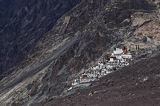
Sankar Monastery, Leh.jpg|[[Sankar Monastery|Sankar Gompa and village]] | |||
Zorawerfort.jpg|[[Zorawar Fort]] | |||
Datun Sahib tree in Leh, 2009.jpg|[[Datun Sahib]] | |||
</gallery> | |||
==Transportation== | ==Transportation== | ||
| Line 210: | Line 336: | ||
*[[National Highway 1 (India)|National Highway 1]] | *[[National Highway 1 (India)|National Highway 1]] | ||
The overland approach to Ladakh from the Kashmir valley via the 434-km. | The overland approach to Ladakh from the Kashmir valley via the 434-km. National Highway 1 typically remains open for traffic from June to October/November. The most dramatic part of this road journey is the ascent up the 3,505 m (11,500 ft.) high [[Zoji-la]], a tortuous pass in the Great Himalayan Wall. The [[Jammu and Kashmir State Road Transport Corporation]] (JKSRTC) operates regular Deluxe and Ordinary bus services between Srinagar and Leh on this route with an overnight halt at Kargil. Taxis (cars and jeeps) are also available at Srinagar for the journey. | ||
*[[National Highway 3 (India)|National Highway 3]] or [[Leh-Manali Highway]] | *[[National Highway 3 (India)|National Highway 3]] or [[Leh-Manali Highway]] | ||
| Line 221: | Line 347: | ||
===Air=== | ===Air=== | ||
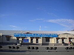
[[File:IXL Front 2010.jpg|thumb|[[Leh Kushok Bakula Rimpochee Airport]]]] | [[File:IXL Front 2010.jpg|thumb|[[Leh Kushok Bakula Rimpochee Airport]]]] | ||
Leh's [[Leh Kushok Bakula Rimpochee Airport]] has flights to Delhi at least daily on [[Air India]] which also provides twice-weekly services to [[Jammu]] and a weekly flight to [[Srinagar]]. Passengers connect in [[Delhi]] for other destinations. [[Go First]] operates | Leh's [[Leh Kushok Bakula Rimpochee Airport]] has flights to Delhi at least daily on [[Air India]] which also provides twice-weekly services to [[Jammu]] and a weekly flight to [[Srinagar]]. Passengers connect in [[Delhi]] for other destinations. [[Go First]] operates Delhi to Leh daily flights during peak time. | ||
===Rail=== | ===Rail=== | ||
| Line 232: | Line 358: | ||
==Media and communications== | ==Media and communications== | ||
State-owned [[All India Radio]] Leh has a local station in Leh, which transmits various programs of mass interest. Leh head post | State-owned [[All India Radio]] Leh has a local station in Leh, which transmits various programs of mass interest. Leh head post office owned by [[India Post]] also serves as a major means of communications. On 14 December 2021, the first FM radio station in Ladakh was established in Leh.<ref>{{Cite news|title=Ladakh gets its first-ever FM radio station|url=https://indianexpress.com/article/india/ladakh-first-ever-fm-radio-station-7673285/|date=2021-12-14|access-date=2021-12-15|work=[[The Indian Express]]}}</ref> | ||
==Gallery== | ==Gallery== | ||
| Line 256: | Line 382: | ||
File:Magnetic_)hill.jpg|Magnetic Hill, Leh, Ladakh | File:Magnetic_)hill.jpg|Magnetic Hill, Leh, Ladakh | ||
</gallery> | </gallery> | ||
==See also== | ==See also== | ||
*[[Dharamshala]] | *[[Dharamshala]] | ||
| Line 309: | Line 434: | ||
[[Category:Leh| ]] | [[Category:Leh| ]] | ||
[[Category:Ladakh]] | [[Category:Ladakh]] | ||
[[Category:Cities and towns in Leh district]] | [[Category:Cities and towns in Leh district]] | ||
[[Category:Indian union territory capitals]] | [[Category:Indian union territory capitals]] | ||
Latest revision as of 02:14, 18 January 2022
 |
Leh | |
|---|---|
City | |
    | |
  Leh  Leh | |
| Coordinates: 34°10′N 77°35′E / 34.16°N 77.58°E | |
| Country |  India India |
| Union Territory |  Ladakh Ladakh |
| District | Leh |
| Government | |
| • Type | Ladakh Autonomous Hill Development Council, Leh |
| Area | |
| • Total | 9.15 km2 (3.53 sq mi) |
| Elevation | 3,500 m (11,500 ft) |
| Population (2011) | |
| • Total | 30,870 |
| • Density | 3,400/km2 (8,700/sq mi) |
| Demographics | |
| • Languages | Ladakhi, Balti, Hindi, English[1] |
| Time zone | UTC+5:30 (IST) |
| Vehicle registration | LA 02 |
| Website | leh |
Leh (/ˈleɪ/) is the joint capital and largest town of the union territory of Ladakh in India. Leh, located in the Leh district, was also the historical capital of the Kingdom of Ladakh, the seat of which was in the Leh Palace, the former residence of the royal family of Ladakh, built in the same style and about the same time as the Potala Palace in Tibet. Leh is at an altitude of 3,524 m (11,562 ft), and is connected via National Highway 1 to Srinagar in the southwest and to Manali in the south via the Leh-Manali Highway.
History[edit | edit source]
.jpeg)
Leh was an important stopover on trade routes along the Indus Valley between Tibet to the east, Kashmir to the west and also between India and China for centuries. The main goods carried were salt, grain, pashm or cashmere wool, charas or cannabis resin from the Tarim Basin, indigo, silk yarn and Banaras brocade.
Although there are a few indications that the Chinese knew of a trade route through Ladakh to India as early as the Kushan period (1st to 3rd centuries CE),[2] and certainly by Tang dynasty,[3] little is actually known of the history of the region before the formation of the kingdom towards the end of the 10th century by the Tibetan prince, Skyid lde nyima gon (or Nyima gon), a grandson of the anti-Buddhist Tibetan king, Langdarma (r. c. 838 to 841). He conquered Western Tibet although his army originally numbered only 300 men. Several towns and castles are said to have been founded by Nyima gon and he apparently ordered the construction of the main sculptures at Shey. "In an inscription, he says he had them made for the religious benefit of the Tsanpo (the dynastical name of his father and ancestors), and of all the people of Ngaris (Western Tibet). This shows that already in this generation Langdarma's opposition to Buddhism had disappeared."[4] Shey, just 15 km east of modern Leh, was the ancient seat of the Ladakhi kings.
During the reign of Delegs Namgyal (1660–1685),[5] the Nawab of Kashmir, which was then a province in the Mughal Empire, arranged for the Mongol army to temporarily leave Ladakh, though it returned later. As payment for assisting Delegs Namgyal in the Tibet-Ladakh-Mughal war of 1679–1684, the Nawab made a number of onerous demands. One of the least was to build a large Sunni Muslim mosque in Leh at the upper end of the bazaar in Leh, below the Leh Palace. The mosque reflects a mixture of Islamic and Tibetan architecture and can accommodate more than 500 people. This was apparently not the first mosque in Leh; there are two smaller ones which are said to be older.[6]
Several trade routes have traditionally converged on Leh, from all four directions. The most direct route was the one the modern highway follows from the Punjab via Mandi, the Kulu valley, over the Rohtang Pass, through Lahaul and on to the Indus Valley, and then downriver to Leh. The route from Srinagar was roughly the same as the road that today crosses the Zoji La (pass) to Kargil, and then up the Indus Valley to Leh. From Baltistan there were two difficult routes: the main on ran up the Shyok Valley from the Indus, over a pass and then down the Hanu River to the Indus again below Khalsi (Khalatse). The other ran from Skardu straight up the Indus to Kargil and on to Leh. Then, there were both the summer and winter routes from Leh to Yarkand via the Karakoram Pass and Xaidulla. Finally, there were a couple of possible routes from Leh to Lhasa.[7]
The first recorded royal residence in Ladakh, built at the top of the high Namgyal ('Victory') Peak overlooking the present palace and town, is the now-ruined fort and the gon-khang (Temple of the Guardian Divinities) built by King Tashi Namgyal. Tashi Namgyal is known to have ruled during the final quarter of the 16th century CE.[8] The Namgyal (also called "Tsemo Gompa" = 'Red Gompa', or dGon-pa-so-ma = 'New Monastery'),[9] a temple, is the main Buddhist centre in Leh.[10] There are some older walls of fortifications behind it which Francke reported used to be known as the "Dard Castle." If it was indeed built by Dards, it must pre-date the establishment of Tibetan rulers in Ladakh over a thousand years ago.[11]
The Sankar Labrang (Bsam dkar bla brang) is a small, two-storeyed building owned by Sankar monastery. Sankar monastery is the seat of Bakula Rinpoche, immediately to the northwest of Leh. The monastery's Labrang building is located in the old town of Leh, in the Manikhang neighbourhood. Manikhang is the area between the main bazaar of Leh and the historic Stalam path that leads up to the royal palace. Four huge stūpas standing at this point mark the beginning of historic Leh. In recent memory, the Sankar Labrang had a metalsmith's workshop downstairs, while upstairs lived the monk caretaker of the White Maitreya Temple (Byams khang dkar po), also known locally as "Street Maitreya". The White Maitreya Temple dates back to the reign of King Drakpa Bumd´e (Grags pa 'bum lde, r. ca 1410–1435), following the arrival of a mission sent to Ladakh by the Tibetan lama Tsongkhapa.[12]
Below this are the Chamba (Byams-pa, i.e., Maitreya) and Chenresi (sPyan-ras-gzigs, i.e. Avalokiteshvara) monasteries which are of uncertain date.[9]
Leh Palace[edit | edit source]

The royal palace, known as Leh Palace, was built by King Sengge Namgyal (1612–1642),[13] presumably between the period when the Portuguese Jesuit priest, Francisco de Azevedo, visited Leh in 1631, and made no mention of it, and Sengge Namgyal's death in 1642.[14]
The Leh Palace is nine storeys high; the upper floors accommodated the royal family, and the stables and storerooms are located on the lower floors. The palace was abandoned when Kashmiri forces besieged it in the mid-19th century. The royal family moved their premises south to their current home in Stok Palace on the southern bank of the Indus River.
- As has already been mentioned, the original name of the town is not sLel, as it is nowadays spelled, but sLes, which signifies an encampment of nomads. These [Tibetan] nomads were probably in the habit of visiting the Leh valley at a time when it had begun to be irrigated by Dard colonisers. Thus, the most ancient part of the ruins on the top of rNam-rgyal-rtse-mo hill at Leh are called 'aBrog-pal-mkhar (Dard castle).[15]
In 2010, Leh was heavily damaged by the sudden floods caused by a cloud burst.
Administration[edit | edit source]
Unlike other districts in India, the Ladakh Autonomous Hill Development Council (LAHDC) is in charge of governance in Leh.
It has 30 councillors, 4 nominated and 26 elected. The Chief Executive Councillor heads and chairs this council. . The 'Deputy Commissioner, Leh' also holds the power of 'Chief Executive Officer of the LAHDC'. The Current Deputy Commissioner of Leh district is Sachin Kumar Vaishya.

The Old Town of Leh[edit | edit source]

The old town of Leh was added to the World Monuments Fund's list of 100 most endangered sites due to increased rainfall from climate change and other reasons.[16] Neglect and changing settlement patterns within the old town have threatened the long-term preservation of this unique site.[17]
The rapid and poorly planned urbanisation of Leh has increased the risk of flash floods in some areas, while other areas, according to research by the Climate and Development Knowledge Network, suffer from the less dramatic, gradual effects of 'invisible disasters', which often go unreported.[18]
Geography[edit | edit source]

The city is located on the bank of the Indus. The mountains dominate the landscape around the Leh as it is at an altitude of 3,500m. Peaks, such as Nanga Sago, can reach well above 5,500m. The principal access roads include the 434 km Srinagar-Leh highway which connects Leh with Srinagar and the 428 km Leh-Manali Highway which connects Manali with Leh. Both roads are open only on a seasonal basis.[19] Although the access roads from Srinagar and Manali are often blocked by snow in winter, the local roads in the Indus Valley usually remain open due to the low level of precipitation and snowfall.
Climate[edit | edit source]
Leh has a cold desert climate (Köppen climate classification BWk) with long, cold winters from late November to early March, with minimum temperatures well below freezing for most of the winter. The city gets occasional snowfall during winter. The weather in the remaining months is generally fine and warm during the day. Average annual rainfall is only 102 mm (4.02 inches). In 2010 the city experienced flash floods which killed more than 100 people.[20]
| Climate data for Leh (1951–1980) | |||||||||||||
|---|---|---|---|---|---|---|---|---|---|---|---|---|---|
| Month | Jan | Feb | Mar | Apr | May | Jun | Jul | Aug | Sep | Oct | Nov | Dec | Year |
| Record high °C (°F) | 8.3 (46.9) |
12.8 (55.0) |
19.4 (66.9) |
23.9 (75.0) |
28.9 (84.0) |
34.8 (94.6) |
34.0 (93.2) |
34.2 (93.6) |
30.6 (87.1) |
25.6 (78.1) |
20.0 (68.0) |
12.8 (55.0) |
34.8 (94.6) |
| Average high °C (°F) | −2.0 (28.4) |
1.5 (34.7) |
6.5 (43.7) |
12.3 (54.1) |
16.2 (61.2) |
21.8 (71.2) |
25.0 (77.0) |
25.3 (77.5) |
21.7 (71.1) |
14.6 (58.3) |
7.9 (46.2) |
2.3 (36.1) |
12.8 (55.0) |
| Average low °C (°F) | −14.4 (6.1) |
−11.0 (12.2) |
−5.9 (21.4) |
−1.1 (30.0) |
3.2 (37.8) |
7.4 (45.3) |
10.5 (50.9) |
10.0 (50.0) |
5.8 (42.4) |
−1.0 (30.2) |
−6.7 (19.9) |
−11.8 (10.8) |
−1.3 (29.7) |
| Record low °C (°F) | −28.3 (−18.9) |
−26.4 (−15.5) |
−19.4 (−2.9) |
−12.8 (9.0) |
−4.4 (24.1) |
−1.1 (30.0) |
0.6 (33.1) |
1.5 (34.7) |
−4.4 (24.1) |
−8.5 (16.7) |
−17.5 (0.5) |
−25.6 (−14.1) |
−28.3 (−18.9) |
| Average rainfall mm (inches) | 9.5 (0.37) |
8.1 (0.32) |
11.0 (0.43) |
9.1 (0.36) |
9.0 (0.35) |
3.5 (0.14) |
15.2 (0.60) |
15.4 (0.61) |
9.0 (0.35) |
7.5 (0.30) |
3.6 (0.14) |
4.6 (0.18) |
105.5 (4.15) |
| Average rainy days | 1.3 | 1.1 | 1.3 | 1.0 | 1.1 | 0.4 | 2.1 | 1.9 | 1.2 | 0.4 | 0.5 | 0.7 | 13.0 |
| Average relative humidity (%) (at 17:30 IST) | 51 | 51 | 46 | 36 | 30 | 26 | 33 | 34 | 31 | 27 | 40 | 46 | 38 |
| Source: India Meteorological Department[21][22] | |||||||||||||
Agriculture[edit | edit source]
.jpg)
Leh is located at an average elevation of about 3500 metres, which means that only one crop a year can be grown there, while two can be grown at Khalatse. By the time crops are being sown at Leh in late May, they are already half-grown at Khalatse. The main crop is grim (naked barley – Hordeum vulgare L. var. nudum Hook. f., which is an ancient form of domesticated barley with an easier to remove hull) – from which tsampa, the staple food in Ladakh, is made.[23] The water for agriculture of Ladakh comes from the Indus, which runs low in March and April when barley-fields have the greatest need for irrigation.[24]
Demographics[edit | edit source]

As of 2011 India census,[25] Leh town had a population of 30,870. Males constitute 70% of the population and females 30%, due to a large presence of non-local labourers, traders and government employees. Child sex ratio is 987. Leh has an average literacy rate of 90%, more than the national average of 74.04%: male literacy is 94.89%, and female literacy is 78.85%. In Leh, 5.5% of the population is under 6 years of age. The people of Leh are ethnic Tibetan, speaking Ladakhi, a Tibetic language.
The Muslim presence dates back to the annexation of Ladakh by Kashmir, after the Fifth Dalai Lama came to Ladakh from Tibet. Since then, there has been further migration from the Kashmir Valley due firstly to trade and latterly with the transfer of tourism from the Kashmir Valley to Ladakh.
Ladakh receives very large numbers of tourists for its size. In 2010, 77,800 tourists arrived in Leh. Numbers of visitors have swelled rapidly in recent years, increasing 77% in the 5 years to 2010. This growth is largely accounted for by larger numbers of trips by domestic Indian travellers.[26]
Religion[edit | edit source]
Buddhism is the largest religion in Leh, followed by over 43.8% of people. Hinduism is the second-largest religion with 35.4% adherents. Islam and Sikhism form 15.14% and 2.7% of the population respectively.[27]
Buddhism is the predominant religion in the valley practiced among Ladakhi people and several Tibetic people. Hinduism has the second largest number of followers after Buddhism. However, as much as 95% of them are male, mostly migrant workers.[28]
Since the 8th century, people belonging to different religions, particularly Buddhism and Islam, have been living in Leh. They co-inhabited the region from the time of early period of Namgyal dynasty and there are no records of any conflict between them. Meer Izzut-oollah wrote in the early 19th century:
This mosque was built by Ibraheem Khan (in the mid 17th century), who was a man of noble family in the service of the descendants of Timoor. In his time the Kalimaks (Calmuck Tartars), having invaded and obtained possession of the greater portion of Thibet [Ladakh], the Raja of that country claimed protection from the Emperor of Hindoostan. Ibraheem Khan was accordingly deputed by that monarch to his assistance, and in a short time succeeded in expelling the invaders and placing the Raja once more on his throne. The Raja embraced the Mahomedan faith, and formally acknowledged himself as a feudatory of the Emperor, who honored him with the title of Raja Akibut Muhmood Khan, which title to the present day is borne by the Ruler of Cashmere.[29]
In recent times, Muslim migration to Leh from neighbouring Kargil and Kashmir has increased due to better opportunities, and relations between the Buddhist and Muslim communities have soured due to socio-political conflicts.[30]
Besides these two communities there are people living in the region who belong to other religions such as Christianity, Hinduism and Sikhism. The small Christian community in Leh are descendants of converts from Tibetan Buddhism by German Moravian missionaries who established a church at Keylong in Lahaul in the 1860s, and were allowed to open another mission in Leh in 1885 and had a sub-branch in Khalatse. They stayed open until Indian Independence in 1947. In spite of their successful medical and educational activities, they made only a few converts.[31]
Every year Sindhu Darshan Festival is held at Shey, 15 km away from town to promote religious harmony and glory of Indus (Sindhu) river. At this time, many tourists visit Leh.[32]
Attractions[edit | edit source]
In Leh
- Leh Palace
- Namgyal Tsemo Gompa
- Shanti Stupa
- Cho Khang Gompa
- Chamba Temple
- Jama Masjid
- Gurdwara Pathar Sahib
- Sankar Gompa and village
- War Museum
- The Victory Tower
- Zorawar Fort
- Ladakh Marathon
- Datun Sahib
- Ice Stupa
-
 Leh Palace View from Leh Market
 -

-

-
-

-


.jpg)


Transportation[edit | edit source]


Road[edit | edit source]
Leh is connected to the rest of India by two high-altitude roads both of which are subject to landslides and neither of which are passable in winter when covered by deep snows. The National Highway 1D from Srinagar via Kargil is generally open longer. The Leh-Manali Highway can be troublesome due to very high passes and plateaus, and the lower but landslide-prone Rohtang Pass near Manali. The third road axis is under construction.
The overland approach to Ladakh from the Kashmir valley via the 434-km. National Highway 1 typically remains open for traffic from June to October/November. The most dramatic part of this road journey is the ascent up the 3,505 m (11,500 ft.) high Zoji-la, a tortuous pass in the Great Himalayan Wall. The Jammu and Kashmir State Road Transport Corporation (JKSRTC) operates regular Deluxe and Ordinary bus services between Srinagar and Leh on this route with an overnight halt at Kargil. Taxis (cars and jeeps) are also available at Srinagar for the journey.
Since 1989, the 473-km Leh-Manali Highway has been serving as the second land approach to Ladakh. Open for traffic from June to late October, this high road traverses the upland desert plateaux of Rupsho whose altitude ranges from 3,660 m to 4,570 m. There are a number of high passes en route among which the highest one, known as Tanglang La, is sometimes (but incorrectly) claimed to be the world's second-highest motorable pass at an altitude of 5,325 m. (17,469 feet). See the article on Khardung La for a discussion of the world's highest motorable passes.
This is the third road axis to Leh. It is currently under construction.
Air[edit | edit source]

Leh's Leh Kushok Bakula Rimpochee Airport has flights to Delhi at least daily on Air India which also provides twice-weekly services to Jammu and a weekly flight to Srinagar. Passengers connect in Delhi for other destinations. Go First operates Delhi to Leh daily flights during peak time.
Rail[edit | edit source]
There is no railway service currently in Ladakh, however 2 railway routes are proposed- the Bilaspur–Leh line and Srinagar–Kargil–Leh line for more information.[33]
Banking facilities[edit | edit source]
List of functioning banks in Leh
Media and communications[edit | edit source]
State-owned All India Radio Leh has a local station in Leh, which transmits various programs of mass interest. Leh head post office owned by India Post also serves as a major means of communications. On 14 December 2021, the first FM radio station in Ladakh was established in Leh.[37]
Gallery[edit | edit source]
-
 View of Leh
 -
 View of Leh from Khardung La Road
 -
 Leh, capital of Ladakh ca. 1857
 -
 The city-square in 1909
 -
 Shanti Stupa, constructed in 1983 by the Japanese
 -
 Namgyal Tsemo Gompa in Leh
 -
 Leh Mosque
 -
 Leh in winter
 -
 Complete view of Leh as seen from Shanti Stupa
 -
 Alternate view
 -
 Leh in summer
 -
 Leh viewed from Stok
 -
 Indus river near Leh
 -
 Landscapes near Leh
 -
 Shanti Stupa, Leh
 -
 Gurudwara Pathar Sahib Leh ,Ladakh
 -
 Gurudwara Pathar Sahib, Leh , Ladakh
 -
 Gurudwara Pathar Sahib, Leh, Ladakh
 -
 Magnetic Hill, Leh, Ladakh


.jpg)


hill.jpg)
See also[edit | edit source]
Footnotes[edit | edit source]
- ↑ Zutshi, Chitralekha (2004). Languages of Belonging: Islam, Regional Identity, and the Making of Kashmir. Hurst & Company. ISBN 9781850656944.
- ↑ Hill (2009), pp. 200-204.
- ↑ Francke (1977 edition), pp. 76-78
- ↑ Francke (1914), pp. 89-90.
- ↑ Francke (1977 edition), p. 20.
- ↑ Francke (1977 edition), pp. 120-123.
- ↑ Rizvi (1996), pp. 109-111.
- ↑ Rizvi (1996), p. 64.
- ↑ 9.0 9.1 Francke (1914), p. 70.
- ↑ Rizvi (1996), pp. 41, 64, 225-226.
- ↑ Rizvi (1996), pp. 226-227.
- ↑ Alexander, André, and Van Shaik, Sam. (2011). The Stone Maitreya of Leh: The Rediscovery and Recovery of an Early Tibetan Monument.. JRAS, Series 3, 21, 4(2011), p. 421.
- ↑ "Incredible India | Leh Palace". www.incredibleindia.org. Retrieved 16 October 2021.
- ↑ Rizvi (1996), pp. 69, 290.
- ↑ Francke (1914), p. 68. See also, ibid, p. 45.
- ↑ "Tourist Boom Brings Threat to Leh's Tibetan Architecture". AFP. 19 August 2007.
- ↑ Tripti Lahiri (23 August 2007). "Ethnic Leh Houses Falling Apart". AFP. Archived from the original on 6 July 2008.
- ↑ Local approaches to harmonising climate adaptation and disaster risk reduction: Lessons from India, Anshu Sharma, Sahba Chauhan and Sunny Kumar, the Climate and Development Knowledge Network, 2014 cdkn.org
- ↑ The Journey from Kashmir
- ↑ Polgreen, Lydia (6 August 2010). "Mudslides Kill 125 in Kashmir". The New York Times. Retrieved 6 August 2010.
- ↑ "Leh Climatological Table Period: 1951–1980". India Meteorological Department. Archived from the original on 25 February 2018. Retrieved 11 April 2015.
- ↑ "Leh Climatological Table Period: 1951–1980". India Meteorological Department. Archived from the original on 21 July 2011. Retrieved 4 April 2020.
- ↑ Rizvi (1996), p. 38.
- ↑ "Jammu & Kashmir - Geography & Geology". Peace kashmir. Archived from the original on 9 August 2016. Retrieved 28 July 2015.
- ↑ "District Census Handbook Leh (Ladakh)" (PDF). Census of India 2011. Directorate of Census Operations (Jammu & Kashmir). pp. 112–113.
- ↑ "Archived copy" (PDF). Archived from the original (PDF) on 24 July 2013. Retrieved 18 May 2012.
{{cite web}}: CS1 maint: archived copy as title (link) - ↑ 27.0 27.1 "Leh City Population". Census India. Retrieved 26 June 2021.
- ↑ "Why Buddhist women are marrying Muslim men in Ladakh". Business Standard.
- ↑ Travels in Central Asia by Meer Izzut-oollah in the Years 1812-13. Translated by Captain Henderson. Calcutta, 1872, p. 12.
- ↑ "Why Buddhist women are marrying Muslim men in Ladakh". Business Standard.
- ↑ Rizvi (1996), p. 212.
- ↑ Sindhu Darshan Festival
- ↑ "How to Reach Leh". The Indian Backpacker. December 2012. Retrieved 2 January 2013.
- ↑ "HDFC Bank, LEH".
- ↑ "Axis Bank, LEH".
- ↑ https://bankifsccode.com/IDBI_BANK_LTD/JAMMU_&_KASHMIR/LADAKH/LEH
- ↑ "Ladakh gets its first-ever FM radio station". The Indian Express. 14 December 2021. Retrieved 15 December 2021.
References[edit | edit source]
- Alexander, André, and Van Shaik, Sam. (2011). The Stone Maitreya of Leh: The Rediscovery and Recovery of an Early Tibetan Monument.. JRAS, Series 3, 21, 4(2011), pp. 421-439.
- Janet Rizvi. Ladakh: Crossroads of High Asia. Second Edition. (1996). Oxford University Press, Delhi. ISBN 0-19-564546-4.
- Cunningham, Alexander. (1854). LADĀK: Physical, Statistical, and Historical with Notices of the Surrounding Countries. London. Reprint: Sagar Publications (1977).
- Francke, A. H. (1977). A History of Ladakh. (Originally published as, A History of Western Tibet, (1907)). 1977 Edition with critical introduction and annotations by S. S. Gergan & F. M. Hassnain. Sterling Publishers, New Delhi.
- Francke, A. H. (1914). Antiquities of Indian Tibet. Two Volumes. Calcutta. 1972 reprint: S. Chand, New Delhi.
- Hilary Keating (July–August 1993). "The Road to Leh". Saudi Aramco World. 44 (4). Houston, Texas: Aramco Services Company: 8–17. ISSN 1530-5821. Archived from the original on 28 September 2012. Retrieved 29 June 2009.
Further reading[edit | edit source]
- Lonely Planet: Trekking in the Himalayas (Walking Guides)
- Indiator: Hill stations in India
External links[edit | edit source]
- Visit Ladakh Daily website - Ladakh Leading News Website
- Population Figures
- City of Leh Thrives as Oasis of Peace in Kashmir
| History |
| ||||||||||||||||||
|---|---|---|---|---|---|---|---|---|---|---|---|---|---|---|---|---|---|---|---|
| Administration | |||||||||||||||||||
| Geography |
| ||||||||||||||||||
| Human settlements | |||||||||||||||||||
| Culture |
| ||||||||||||||||||
| Tourism and wildlife |
| ||||||||||||||||||
| Transport |
| ||||||||||||||||||
| Infrastructure |
| ||||||||||||||||||
| See also |
| ||||||||||||||||||
