| leader_name2 = Manesh Kumar Meena, IAS<ref>{{Cite web|url=http://timesofindia.indiatimes.com/articleshow/80075785.cms|title=About Municipal Commissioner of Darbhanga|website=[[The Times of India]]}}</ref>
| subdivision_type1 = [[States and territories of India|State]]
| leader_title3 = MP
| subdivision_type3 = [[List of districts of India|District]]
| leader_name3 = [[Gopal Jee Thakur]], [[BJP]]
| subdivision_name1 = {{flagicon image|Bihar Government Banner.png}} [[Bihar]]
| leader_title4 = MLA
| subdivision_type2 = [[Administrative divisions of India|Region]]
| leader_name4 = [[Sanjay Saraogi]], [[BJP]]
| subdivision_name2 = [[Mithila (region)|Mithila]]<ref>{{cite web|last=Thakur |first=Ripunjay Kumar |date=1 March 2022|title=Historical Geography of Early Medieval Mithila: From Videha to Tirhut.|url=https://www.academia.edu/72670545|publisher=New Archaeological & Genological Society, Kanpur, India|issn=2348-8301|access-date=21 August 2025}}</ref>
| demographics1_info2 = [[Urdu]]<ref>{{Cite web|url=http://nclm.nic.in/shared/linkimages/NCLM52ndReport.pdf|title=NCLM52ndReport|date=25 May 2017|archive-url=https://web.archive.org/web/20170525141614/http://nclm.nic.in/shared/linkimages/NCLM52ndReport.pdf|archive-date=25 May 2017}}</ref>
| utc_offset1 = +5:30
| demographics1_title3 = Regional Language
| postal_code_type = [[Postal Index Number|PIN]]
| demographics1_info3 = [[Maithili language|Maithili]]<ref name="langoff">{{cite web|title=52nd Report of the Commissioner for Linguistic Minorities in India|url=http://nclm.nic.in/shared/linkimages/NCLM52ndReport.pdf|website=nclm.nic.in|publisher=[[Ministry of Minority Affairs]]|access-date=22 January 2019|url-status=dead|archive-url=https://web.archive.org/web/20170525141614/http://nclm.nic.in/shared/linkimages/NCLM52ndReport.pdf|archive-date=25 May 2017}}</ref>
| postal_code = 846001–846009<ref>{{cite web |title=STD & PIN Codes |url=https://darbhanga.nic.in/std-pin-codes/ |access-date=23 January 2020}}</ref><ref>{{Cite web|url=https://indiapincodes.net/Bihar/Darbhanga/|title=Pin Codes of Darbhanga, Bihar, India, Darbhanga Pincode Search|website=indiapincodes.net}}</ref>
| demographics1_info1 = [[Hindi]]<ref name="langoff">{{cite web|title=52nd Report of the Commissioner for Linguistic Minorities in India|url=http://nclm.nic.in/shared/linkimages/NCLM52ndReport.pdf|website=nclm.nic.in|publisher=[[Ministry of Minority Affairs]]|access-date=22 January 2019|url-status=dead|archive-url=https://web.archive.org/web/20170525141614/http://nclm.nic.in/shared/linkimages/NCLM52ndReport.pdf|archive-date=25 May 2017}}</ref>
| demographics1_title2 = Additional official
| demographics1_info2 = [[English language|English]]<ref>{{Cite web|url=http://nclm.nic.in/shared/linkimages/NCLM52ndReport.pdf|title=NCLM52ndReport|date=25 May 2017|archive-url=https://web.archive.org/web/20170525141614/http://nclm.nic.in/shared/linkimages/NCLM52ndReport.pdf|archive-date=25 May 2017}}</ref>
'''Darbhanga''' is the fifth-largest city and [[municipal corporation]] in the Indian state of [[Bihar]] situated centrally in Mithila region.
Darbhanga is the headquarters of the [[Darbhanga district]] and the [[Darbhanga division]]. It was the seat of the erstwhile [[Raj Darbhanga|Khandwala]] dynasty. It was the capital of [[Mithila (proposed Indian state)|Mithila]].
'''Darbhanga''' is the [[List of cities in Bihar by population|fifth largest city]] and [[municipal corporation]] in the [[States and union territories of India|Indian state]] of [[Bihar]] in [[India]], and is considered an important city in [[North Bihar]]. It serves as the headquarters of the [[Darbhanga district]] and the [[Darbhanga division]]. Darbhanga is also referred to as the ''gateway to Bengal'', because it is held that the name Darbhanga has been derived from ''Dwār Banga'' or ''Dari – Banga'', meaning the 'door of [[Bengal]]'.<ref>{{Cite web |title=Welcome to Darbhanga District {{!}} Official Website of Darbhanga District {{!}} India |url=https://darbhanga.nic.in/ |access-date=2023-05-18 |language=en-US}}</ref>
Darbhanga was the seat of the erstwhile [[Raj Darbhanga|Khandwala]] zamidaar dynasty under the [[Mughals]] and [[British India]]. It is considered an important medical centre of North Bihar as it is the location of the [[Darbhanga Medical College and Hospital]], and the second [[All India Institutes of Medical Sciences|AIIMS]] of Bihar i.e [[All India Institute of Medical Sciences, Darbhanga|AIIMS Darbhanga]] is to be constructed here.<ref>{{cite web|url=https://timesofindia.indiatimes.com/city/patna/best-site-chosen-for-aiims-at-dbhanga/articleshow/98646390.cms|title='Best site chosen for AIIMS at Darbhanga'|work=The Times of India |date=15 March 2023}}</ref><ref>{{Cite web |title=संसद में गोपाल जी ठाकुर ने उठाई दरभंगा में एम्स की मांग |url=https://www.jagran.com/bihar/darbhanga-gopal-ji-thakur-raised-the-demand-of-aiims-in-darbhanga-in-parliament-19385549.html |access-date=2023-03-31 |website=Dainik Jagran |language=hi}}</ref><ref>{{Cite news |title=एम्स का मुद्दा संसद में उठाए जाने पर सांसद को दी गई बधाई |url=https://www.bhaskar.com/bihar/darbhanga/news/congratulations-to-mp-for-raising-aiims-issue-in-parliament-072004-4963860.html}}</ref><ref>{{Cite web |title=संसद में फिर गूंजा दरभंगा एम्स निर्माण का मुद्दा सांसद ने कहासरकार बदलने से फंसा है पेंच |url=https://www.etvbharat.com/hindi/bihar/state/darbhanga/matter-of-construction-of-darbhanga-aiims-echoed-again-in-parliament/bh20221212200351380380095 |access-date=2023-03-31 |website=ETV Bharat News |language=hindi}}</ref> Darbhanga is the second city in the state of Bihar, where [[Software Technology Park of India, Darbhanga|Software Technology Park of India]] (STPI) has been established.<ref>{{Cite web |title=68th STPI Centre Inaugurated in Darbhanga, Bihar |url=http://stpi.in/en/whats-new/68th-stpi-centre-inaugurated-darbhanga-bihar}}</ref> Similarly by the end of year 2029, it is expected that the city will be equipped with modern infrastructure of metro railway services called as [[Darbhanga Metro]] having 18.8 kilometres long metro line with 18 metro stations on it.<ref>{{Cite web |date=2025-02-17 |title=Metro Survey: मुजफ्फरपुर और दरभंगा में मेट्रो सर्वे हुआ पूरा, नगर विकास विभाग को सौंपी रिपोर्ट |url=https://www.prabhatkhabar.com/state/bihar/patna/metro-survey-completed-in-muzaffarpur-and-darbhanga-report-submitted-to-urban-development-department#amp_tf=From%20%251$s&aoh=17397684806865&csi=0&referrer=https://www.google.com&share=https://www.prabhatkhabar.com/state/bihar/patna/metro-survey-completed-in-muzaffarpur-and-darbhanga-report-submitted-to-urban-development-department |access-date=2025-02-23 |website=Prabhat Khabar |language=hi}}</ref><ref>{{Cite web |title=Darbhanga Metro: 18 स्टेशन... 18.8 KM लंबाई, दरभंगा वाले अब जल्द लेंगे मेट्रो का मजा; जानें लेटेस्ट अपडेट |url=https://navbharattimes.indiatimes.com/state/bihar/darbhanga/darbhanga-metro-coming-soon-18-stations-18-8-km-long-route-airport-to-aiims-connectivity/articleshow/118447859.cms |access-date=2025-02-23 |website=Navbharat Times |language=hi}}</ref> On 29 October 2025, the [[Ministry of Home Affairs (India)|union home minister]] [[Amit Shah]] announced to build a grand [[Mithila Cultural Museum]] in the city to preserve the cultural heritage of the Mithila region.<ref>{{Cite web |title=दरभंगा में 500 करोड़ की लागत से स्थापित होगा सांस्कृतिक म्यूजियम, गृहमंत्री अमित शाह ने की घोषणा - home minister amit shah said that cultural museum will be established in darbhanga bihar politics |url=https://www.jagran.com/elections/bihar-vidhan-sabha-home-minister-amit-shah-said-that-cultural-museum-will-be-established-in-darbhanga-bihar-politics-40022793.html |access-date=2025-10-31 |website=Jagran |language=hi}}</ref>
Darbhanga is one of the oldest cities in India. Musical, folk art, and literary traditions in Sanskrit and Maithili have been passed down generations in Darbhanga and constitute the city's strong cultural background.<ref>{{cite web|url=https://darbhanga.nic.in/culture-heritage/|title= Darbhanga : Heart of Mithilaanchal}}</ref>
Darbhanga is one of the oldest cities in India. Musical, folk art, and literary traditions in [[Maithili language|Maithili]], Sanskrit, [[Urdu]], and Hindi have been passed down through generations in Darbhanga and constitute the city's strong cultural background. It is popularly known as the "Cultural Capital of Bihar" and the "Heart of [[Mithila (region)|Mithila]]".significant district in the Mithila region of North Bihar, India<ref>{{cite web |author=Culture |url=https://darbhanga.nic.in/culture-heritage/ |title=Darbhanga: The Heart of Mithilaanchal! |work=Darbhanga.nic.in |access-date=30 December 2020}}</ref>
==History==
==History==
{{See also|Raj Darbhanga}}
{{See also|Raj Darbhanga}}
The city was the capital of the Darbhanga Raj, an estate established in the 16th century, and contains the Anandbagh Palace. It was constituted a municipality in 1864. Darbhanga is home to the Kameshwara Singh Darbhanga Sanskrit University (1961), which is located on the grounds of the palace, and the Lalit Narayan Mithila University (1972). Darbhanga has a museum housing archaeological materials, as well as historical and handicrafts exhibits. Darbhanga has been a centre for music since the late 18th century and has produced multiple well-known ''dhrupad'' (an ancient form of Indian classical music) musicians. A major rail and road junction, Darbhanga trades in agricultural produce, mangoes, and fish. In addition to food processing, the city has a light manufacturing industry.
The city was the capital of the [[Raj Darbhanga|Darbhanga Raj]], an [[Zamindars of Bihar|estate]] established in the [[16th century]], containing the [[Anand Bagh Palace|Anandbagh Palace]]. It was constituted as a municipality in 1864. Darbhanga is home to the [[Kameshwar Singh Darbhanga Sanskrit University|Kameshwara Singh Darbhanga Sanskrit University]] (established 1961), which is located on the grounds of the palace, and the [[Lalit Narayan Mithila University]] (established 1972). Darbhanga has a museum housing archaeological materials, as well as historical and handicrafts exhibits.
Darbhanga has been a centre for music since the late 18th century and has produced multiple well-known ''[[dhrupad]]'' (an ancient form of Indian classical music) musicians. A major rail and road junction, Darbhanga trades in agricultural produce, mangoes, and fish. In addition to food processing, the city has a light manufacturing industry.
Darbhanga is situated on a vast alluvial plain, with low-lying areas containing marshes and lakes. Grains, oilseeds, tobacco, sugarcane, and mangoes are important crops in the region.<ref>{{Cite web|title=Darbhanga {{!}} India|url=https://www.britannica.com/place/Darbhanga|access-date=17 June 2021|website=Encyclopedia Britannica|language=en}}</ref>
Darbhanga is situated on a vast alluvial plain, with low-lying areas containing marshes and lakes. Grains, oilseeds, tobacco, sugarcane, and mangoes are important crops in the region.<ref>{{Cite web|title=Darbhanga {{!}} India|url=https://www.britannica.com/place/Darbhanga|access-date=17 June 2021|website=Encyclopedia Britannica|language=en}}</ref>
Under the [[British Raj]], Darbhanga was a part of Sarkar Tirhut until 1875, when it was constituted into a separate district. Its subdivisions had been constituted earlier – Darbhanga Sadar in 1845, Madhubani in 1866, and Samastipur (then known as Tajpur) in 1867.
Under the [[British Raj]], Darbhanga was a part of Sarkar Tirhut until 1875, when it was constituted into a separate district. Its subdivisions had been constituted earlier – Darbhanga Sadar in 1845, Madhubani in 1866, and Samastipur (then known as Tajpur) in 1867.
The city of Darbhanga is said to have been founded by one Darbhangi Khan, about whom practically nothing is known. It is also held that the name Darbhanga is derived from Dwar Banga or Dar-e-Banga, meaning the ‘door of Bengal’. This etymology does not appear to be very correct as the division between Bengal and Bihar has always been held to be further to the east. Nonetheless, the region has a linguistic and cultural affinity with Bengal.<ref>{{Cite web|title=History {{!}} Welcome to Darbhanga District {{!}} India|url=https://darbhanga.nic.in/history/|access-date=17 June 2021|language=en-US}}</ref>
The city of Darbhanga is said to have been founded by one Darbhangi Khan, about whom practically nothing is known. It is also held that the name Darbhanga is derived from ''Dwar Banga'' or ''Dar-e-Banga'', meaning the 'door of Bengal'. This etymology does not appear to be accurate as the division between Bengal and Bihar has always been held to be further to the east. Nonetheless, the region has a linguistic and cultural affinity with Bengal.<ref>{{Cite web|title=History {{!}} Welcome to Darbhanga District {{!}} India|url=https://darbhanga.nic.in/history/|access-date=17 June 2021|language=en-US}}</ref>
Excavation at Balirajgarh revealed brick fortifications dating back to the 2nd century BC.<ref>{{Cite book|title=Indian Archaeology:A Review|last=A.|first=Ghosh|publisher=Archaeological Survey of India|year=1965|location=New Delhi|pages=3–5}}</ref>
==Demographics==
{{bar box
|title=Religions in Darbhanga Town
|titlebar=#Fcd116
|left1=Religion
|right1=Percent
|float=right
|bars=
{{bar percent|[[Hindus]]|orange|71.76}}
{{bar percent|[[Muslims]]|green|27.76}}
{{bar percent|Christian|blue|0.18}}
{{bar percent|Sikh|olive|0.11}}
{{bar percent|Buddhist|yellow|0.01}}
{{bar percent|Jain|brown|0.01}}
{{bar percent|Not Stated|black|0.16}}
}}
{{see also|List of cities in Bihar}}
The [[2011 Census of India]] recorded Darbhanga as an Urban agglomeration with a population of 380,125 while the surrounding district has 3 million people.<ref>{{cite web |url=https://www.census2011.co.in/census/city/164-darbhanga.html |title = Darbhanga City Population Census 2011-2022 {{!}} Bihar}}</ref> It is the 5th largest city in Bihar in terms of the urban population.<ref>https://cdn.s3waas.gov.in/s3beed13602b9b0e6ecb5b568ff5058f07/uploads/2021/03/2021030687.pdf {{Bare URL PDF|date=January 2022}}</ref> The city has 196,573 males (52.6%) and 183,552 females (47.4%). Darbhanga has an average literacy rate of 79.40%, with male literacy at 85.08% and female literacy at 73.08%.<ref>{{Cite web|date=2001|title=Census of India: View Population Details|url=http://www.censusindia.gov.in/PopulationFinder/View_Village_Population.aspx?pcaid=1384&category=M.Corp.|url-status=live|archive-url=https://web.archive.org/web/20160427193419/http://www.censusindia.gov.in/PopulationFinder/View_Village_Population.aspx?pcaid=1384&category=M.Corp.|archive-date=27 April 2016|access-date=14 January 2016|website=www.censusindia.gov.in|publisher=Government of India}}</ref> However, as per the document published on 6 March 2021 by the office of District Magistrate Darbhanga, the urban population of Darbhanga stands 380,125<ref>https://cdn.s3waas.gov.in/s3beed13602b9b0e6ecb5b568ff5058f07/uploads/2021/03/2021030687.pdf {{Bare URL PDF|date=January 2022}}</ref>
[[Darbhanga Railway Station|Darbhanga Junction]] lies on the [[East Central Railway Zone (India)|East Central Railway]]. It is connected directly to all the major cities of India.
Of the beginning of railway in Darbhanga and its neighbouring areas, ''[[The Imperial Gazetteer of India]]'' noted:
{{blockquote|The famine of 1874 gave a great impetus to the construction of railways, and the District is on the whole well off in the matter of communications. Its southwest corner is traversed for 29 miles by the mainline of the Bengal and North-Western Railway, and also by 25 miles of the new chord-line from Hajipur to Bachwara, which runs parallel to the Ganges embankment from east to west. From Samastipur a line runs to Darbhanga town and there branches off in two directions, the first north-west to Sitamarhi through Kamtaul and Jogiara, and the other due east to Khanwa Ghat on the Kosi (Old Stream) near Pratapganj. The total length of the line within the District is 146 miles. Most of the earthwork for a line from Sakri to Jainagar on the Nepal frontier was completed as relief work during the famine of 1897; and the line, which has now been opened, should tap a large grain supply from Nepal.<ref>{{cite web |url=https://dsal.uchicago.edu/reference/gazetteer/text.html?objectid=DS405.1.I34_V11_164.gif |title=Archived copy |access-date=2016-01-14 |url-status=live |archive-url=https://web.archive.org/web/20160304205257/http://dsal.uchicago.edu/reference/gazetteer/text.html?objectid=DS405.1.I34_V11_164.gif |archive-date=4 March 2016}}</ref>}}
Darbhanga also has its own commercial airport which is connected with all the major cities of India.
'''[[Darbhanga Airport]]''' ([[IATA airport code|IATA]]: '''DBR''', [[ICAO airport code|ICAO]]: '''VE89''') is a [[civil enclave]] at the Darbhanga Air Force Station of the [[Indian Air Force]], 6 kilometres from Darbhanga City near the NH-105 and NH-57 East-West Corridor Expressway which passes through Darbhanga. The civil enclave is operated by the [[Airports Authority of India]] (AAI). The foundation stone for the project was laid by Chief Minister [[Nitish Kumar]] and then Civil Aviation Minister [[Suresh Prabhu]] in the presence of state Civil Aviation Minister [[Jayant Sinha]] on 24 December 2018. Commercial flights started on 8 November 2020.<ref>{{Cite web|title=मिथिलांचल के लिए खुशखबरी! दरभंगा एयरपोर्ट का संचालन शुरू, देखिए अंदर की तस्वीरें|url=https://www.prabhatkhabar.com/state/bihar/darbhanga/good-news-for-mithila-darbhanga-airport-starts-operating-see-inside-photos-asj|access-date=8 November 2020|website=Prabhat Khabar - Hindi News|language=hi}}</ref>
===Roadways===
[[File:Nh 57 Bihar.jpg|thumb|left|[[National Highway 27 (India)|NH 27]] which is part of India's [[North–South and East–West Corridor|East–West highway corridor]] passes through Darbhanga]]
Darbhanga is connected to other parts of India by [[National Highway 27 (India)|National Highway 27]], [[National Highway 527B (India)|National Highway 527B]] and [[List of state highways in Bihar|Bihar State highways]] 50, 56, 88 and 75. Darbhanga is also connected to Madhubani and [[Sitamarhi]].
The [[North–South and East–West Corridor|East-West Corridor]] expressway, which connects [[Porbandar]] in [[Gujarat]] to [[Silchar]] in [[Assam]], passes through Darbhanga.
Excavation at [[Baliraajgadh|Balirajgarh]] revealed brick fortifications dating back to the 2nd century BC.<ref>{{Cite book|title=Indian Archaeology:A Review|last=A.|first=Ghosh|publisher=Archaeological Survey of India|year=1965|location=New Delhi|pages=3–5}}</ref>
==Geography==
==Geography==
Darbhanga is located in the northern part of [[Bihar]].
Darbhanga is located in the northern part of [[Bihar]]. It lies between 25.53 degrees - 26.27 degrees N and 85.45 degrees - 86.25 degrees E at an average elevation of 171 feet (52 m). Darbhanga district covers an area of 2,279 sq km. Darbhanga is bounded by [[Madhubani district]] in the north, [[Samastipur district]] in the south, [[Saharsa district]] in the east, and [[Sitamarhi district]] and [[Muzaffarpur district]] in the west. Being located in Mithilanchal, Darbhanga district has a vast fertile alluvial plain devoid of any hills. It has a gentle slope from north to south direction having a depression in the centre. Darbhanga experiences a humid subtropical climate. It experiences three main seasons which are winter, summer, and rainy seasons. May is the hottest month when the temperature reaches up to 43 °C. Darbhanga district receives an average of 1142.3 mm rainfall and almost 92% of the annual rainfall is received during [[Monsoon of South Asia|monsoon]].
|server = [[National Oceanic and Atmospheric Administration]]
|url-status = live
}}</ref>
}}
}}
==Demographics==
{{bar box
|title=Religion in Darbhanga city (2011)<ref name="religion">{{Cite web |date=2011 |title=Table C-01 Population by Religion: Bihar |url=https://censusindia.gov.in/nada/index.php/catalog/11366/download/14479/DDW10C-01%20MDDS.XLS |website=censusindia.gov.in |publisher=[[Registrar General and Census Commissioner of India]]}}</ref>
The [[2011 Census of India]] recorded Darbhanga as an Urban agglomeration with a population of 296,039 while the surrounding district has 3 million people.<ref>{{cite web |url=https://www.census2011.co.in/census/city/164-darbhanga.html |title = Darbhanga City Population Census 2011-2022 {{!}} Bihar}}</ref> It is the 5th largest city in Bihar in terms of the urban population.<ref name="auto">{{Cite web|url=https://cdn.s3waas.gov.in/s3beed13602b9b0e6ecb5b568ff5058f07/uploads/2021/03/2021030687.pdf|title=2021030687.pdf}}</ref> The city has 196,573 males (52.6%) and 183,552 females (47.4%). Darbhanga has an average literacy rate of 79.40%, with male literacy at 85.08% and female literacy at 73.08%.<ref>{{Cite web|date=2001|title=Census of India: View Population Details|url=http://www.censusindia.gov.in/PopulationFinder/View_Village_Population.aspx?pcaid=1384&category=M.Corp.|url-status=live|archive-url=https://web.archive.org/web/20160427193419/http://www.censusindia.gov.in/PopulationFinder/View_Village_Population.aspx?pcaid=1384&category=M.Corp.|archive-date=27 April 2016|access-date=14 January 2016|website=www.censusindia.gov.in|publisher=Government of India}}</ref> However, as per the document published on 6 March 2021 by the office of District Magistrate Darbhanga, the urban population of Darbhanga stands 380,125.<ref name="auto"/>
===Languages===
{{Pie chart
|thumb = righ
|caption = Languages spoken in Dharbhanga City (2011)<ref>[https://censusindia.gov.in/2011census/C-16T/DDW-C16-TOWN-STMT-MDDS-2000.XLSX 2011 census data] censusindia.gov.in</ref>
[[Darbhanga Railway Station|Darbhanga Junction]] lies on the [[East Central Railway Zone (India)|East Central Railway]]. It is connected directly to all the major cities of India. [[Laheriasarai Railway Station]] is the second major station of Darbhanga and works as an important railway station for people living in south Darbhanga.
There are daily and weekly trains available for {{rws|New Delhi}}, {{rws|Patna Junction}}, {{rws|Secunderabad}}, {{rws|Kolkata}}, {{rws|Varanasi}}, {{rws|Ahmedabad}}, [[Lokmanya Tilak Terminus]], {{rws|Howrah}}, {{rws|Amritsar}}, {{rws|Pune}} and other major cities.
Darbhanga also has its own commercial airport which is connected with all the major cities of India.
[[Darbhanga Airport]] ([[IATA airport code|IATA]]: '''DBR''', [[ICAO airport code|ICAO]]: '''VE89''') is a [[civil enclave]] at the Darbhanga Air Force Station of the [[Indian Air Force]], 6 kilometres from Darbhanga City near the {{jct|NH|527B|country=IND}} and {{jct|NH|27|country=IND}} East-West Corridor Expressway which passes through Darbhanga. The civil enclave is operated by the [[Airports Authority of India]] (AAI). The foundation stone for the project was laid by Chief Minister [[Nitish Kumar]] and then Civil Aviation Minister [[Suresh Prabhu]] in the presence of state Civil Aviation Minister [[Jayant Sinha]] on 24 December 2018. After efforts taken by the [[Member of Parliament (India)|MP]] of Darbhanga, [[Gopal Jee Thakur]],<ref>{{Cite web |last=शर्मा |first=सुभाष |date=2020-09-05 |title=दरभंगा एयरपोर्ट से जल्द ही उड़ान भरेंगे विमान, MP गोपाल जी ठाकुर ने अधिकारियों से की बात |url=https://www.abplive.com/states/bihar/aircraft-to-fly-from-darbhanga-airport-soon-mp-gopal-ji-thakur-speaks-to-officials-ann-1552623 |access-date=2023-09-30 |website=www.abplive.com |language=hi}}</ref><ref>{{Cite web |title=सांसद गोपाल जी ठाकुर बोले, आठ नवंबर से 8 करोड़ मथिलावासियों के लिए शुरू होगी हवाई सेवा - MP Gopal ji Thakur said that Air service will start for 8 crore Mathilawas from November 8 |url=https://www.jagran.com/bihar/muzaffarpur-mp-gopal-ji-thakur-said-that-air-service-will-start-for-8-crore-mathilawas-from-november8-20779315.html |access-date=2023-09-30 |website=Jagran |language=hi}}</ref> and the then Civil Aviation Minister, [[Hardeep Singh Puri]]. Commercial flights started on 8 November 2020.<ref>{{Cite web|title=मिथिलांचल के लिए खुशखबरी! दरभंगा एयरपोर्ट का संचालन शुरू, देखिए अंदर की तस्वीरें|url=https://www.prabhatkhabar.com/state/bihar/darbhanga/good-news-for-mithila-darbhanga-airport-starts-operating-see-inside-photos-asj|access-date=8 November 2020|website=Prabhat Khabar - Hindi News|date=8 November 2020 |language=hi}}</ref>
===Roadways===
{{jct|NH|27|country=IND}} which is part of India's [[North–South and East–West Corridor|East–West highway corridor]] passes through Darbhanga.
Darbhanga is connected to other parts of India by {{jct|NH|27|country=IND}},{{jct|NH|527B|country=IND}} and [[List of state highways in Bihar|Bihar State highways]] 50, 56, 88 and 75. Darbhanga is also connected to [[Muzaffarpur]], [[Samastipur]], [[Madhubani, Bihar|Madhubani]] and [[Sitamarhi]].
The [[North–South and East–West Corridor|East-West Corridor]] expressway, which connects [[Porbandar]] in [[Gujarat]] to [[Silchar]] in [[Assam]], passes through Darbhanga.
The Amas–Darbhanga Expressway{{jct|NH|119D|country=IND}} is an approved 4/6-lane wide access-controlled expressway in India. Once completed, it will be the first expressway in the state of Bihar. {{jct|NH|119D|country=IND}} connects Amas village in Gaya district to Bela Nawada village in Darbhanga district.
==Education==
==Education==
Line 289:
Line 324:
===Medical colleges===
===Medical colleges===
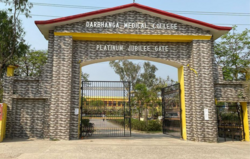
[[File:Darbhanga Medical College Entry Gate.jpg|alt=|thumb|Platinum Jubilee gate of Darbhanga Medical College and Hospital]]
[[File:D.M.C.H.png|alt=|thumb|Platinum Jubilee gate of Darbhanga Medical College and Hospital]]
<!---♦♦♦ Only add an educational institution to this list if it already has its own article on the English Wikipedia ♦♦♦--->
<!---♦♦♦ Only add an educational institution to this list if it already has its own article on the English Bharatpedia ♦♦♦--->
<!---♦♦♦ Please keep the lists in alphabetical order ♦♦♦--->* [[All India Institutes of Medical Sciences|All India Institutes of Medical Sciences (AIIMS) Darbhanga( Under Construction )]]
<!---♦♦♦ Please keep the lists in alphabetical order ♦♦♦--->* [[All India Institute of Medical Sciences, Darbhanga|All India Institutes of Medical Sciences (AIIMS) Darbhanga (Under Construction )]]
* [[Darbhanga Medical College and Hospital]]
* [[Darbhanga Medical College and Hospital]]
* [[Mithila Minority Dental College and Hospital]]
===University===
===University===
<!---♦♦♦ Only add an educational institution to this list if it already has its own article on the English Bharatpedia ♦♦♦--->
<!---♦♦♦ Only add an educational institution to this list if it already has its own article on the English Wikipedia ♦♦♦--->
<!---♦♦♦ Please keep the lists in alphabetical order ♦♦♦--->* [[Indira Gandhi National Open University|Indira Gandhi National Open University (IGNOU)]] Regional Centre
<!---♦♦♦ Please keep the lists in alphabetical order ♦♦♦--->* [[Indira Gandhi National Open University|Indira Gandhi National Open University (IGNOU)]] Regional Centre
*[[Maharajadhiraj lakmeshwar singh museum Darbhanga]]
*[[Maharajadhiraja Lakshmishwar Singh Museum]]
*Villages Of Dharbhanga
*[[Darbhanga Planetarium]]
and much more....make it one of [[Bihar]]'s most visited city both by foreign and domestic tourists.
*[[Shyama Mai Temple]]
*[[Nargona Palace]]
==Media and communications==
*[[Anand Bagh Palace]]
[[All India Radio]] has a 20 kW medium-wave radio station in Darbhanga which transmits various programmes of mass interest and covers a part of North Bihar as well as the Terai of Nepal.{{citation needed|date=October 2018}}
*[[Raj Darbhanga]]
*[[Ahalya Sthan]]
[[Doordarshan]] has one [[DD National]] and one [[DD News]] LPT relay transmitters.{{citation needed|date=October 2018}}
*[[Gautam Ashram]]
*[[Kusheshwar Asthan]]
*[[Kankali Mata Temple]]
==Notable people==
==Notable people==
*[[Kameshwar Singh]] Maharaja
<!---♦♦♦ Only add a person to this list if they already have their OWN article on the English Bharatpedia ♦♦♦--->
*[[Lakshmeshwar Singh]] Maharaja
<!---♦♦♦ Please keep the list in alphabetical order by LAST NAME ♦♦♦--->
*[[Rameshwar Singh]] Maharaja
*[[Imtiaz Ali (director)|Imtiaz Ali]], Bollywood director
*[[Sanjay Mishra (actor)|Sanjay Mishra]], Bollywood actor
*[[Kirti Azad]], former MP and cricketer
*[[Ram Gopal Bajaj]], Indian actor and academic
*[[Narayan Das (Bihar politician)|Narayan Das]], politician
*[[Veena Devi]], politician and member of the 17th Lok Sabha
*[[Veena Devi]], politician and member of the 17th Lok Sabha
*[[Abdul Bari Siddiqui]], MLA
*[[Betty von Fürer-Haimendorf]], ethnologist
*[[Badri Narain Sinha]], IPS
*[[Gaṅgeśa]] (Gangesha Upadhyaya), mathematician and philosopher
*[[Bhawana Kanth]], first female fighter pilot of India
*[[Dharamshila Gupta]], Member of Parliament, Rajya Sabha
*[[Binod Bihari Verma]], writer
*[[File:Asha Jha Artist Madhubani Painting.jpg|thumb|Asha Jha Madhubani Painting Artist (Darbhanga)]]Asha Jha, Madhubani Painting Artist
*[[Binodanand Jha]], former MP
*[[Binodanand Jha]], former MP
*[[Gangesha Upadhyaya]], mathematician and philosopher
*[[Jyoti Kumari]], [[Sirhulli]], cyclist and [[Pradhan Mantri Rashtriya Bal Puraskar|Bal Puraskar]] recipient 2021<ref>{{Cite web|date=26 January 2021|first=Binay Kumar|last=Jha|title=Republic Day: Darbhanga 'cycle girl' Jyoti Kumari gets PM's award|url=https://timesofindia.indiatimes.com/city/patna/darbhanga-cycle-girl-gets-pms-award-ahead-of-r-day/articleshow/80455201.cms|access-date=2 March 2021|website=The Times of India|language=en}}</ref>
* [[Aishwarya Sushmita]], model and actress
*[[Tariq-ur-Rehman]], cricketer
*[[Gopal Jee Thakur]], BJP leader and Current Member of Parliament from Darbhanga.<ref>{{Cite web |title=Members : Lok Sabha |url=https://loksabha.nic.in/Members/MemberBioprofile.aspx?mpsno=5176 |access-date=2023-03-01 |website=loksabha.nic.in}}</ref>
*[[Tochi Raina]], singer, composer, and philosopher
*[[H. C. Verma]], physicist
*[[Yamuna Karjee]], Indian independence activist
*[[Manas Bihari Verma]], Padam Shri decorated Aeronautical scientist, LCA Tejas<ref>{{cite news| url = https://www.thehindu.com/news/national/other-states/former-president-kalams-close-associate-scientist-manas-verma-dies/article34479522.ece | title = Former President Kalam's close associate scientist Manas Verma dies | newspaper = The Hindu| date = 4 May 2021}}</ref>
*[[Betty von Fürer-Haimendorf]], ethnologist
*[[M J Warsi]], [[linguist]]
*[[Ritviz]], electronic singer
*[[Ashok Kumar Yadav]], MP from Madhubani Lok Sabha constituency
*[[Manas Bihari Verma]], Padam Shri decorated Aeronautical scientist, LCA Tejas<ref>{{cite web| url = https://www.thehindu.com/news/national/other-states/former-president-kalams-close-associate-scientist-manas-verma-dies/article34479522.ece| title = Former President Kalam's close associate scientist Manas Verma dies - The Hindu}} </ref>
*[[Hukmdev Narayan Yadav]], former MP
==See also==
==See also==
* [[Laheriasarai]]
*[[Darbhanga AIIMS]]
* [[Darbhanga Planetarium]]
*[[Software Technology Park of India, Darbhanga]]
*{{Portal-inline|India|size=tiny}}
*[[Patna]]
==References==
==References==
Line 395:
Line 450:
==External links==
==External links==
{{wikimedia|voy=Darbhanga}}
{{sister project links|voy=Darbhanga}}
* {{official website}}
* {{official website}}
Line 406:
Line 461:
[[Category:Darbhanga| ]]
[[Category:Darbhanga| ]]
[[Category:Subdivisions of Darbhanga district]]
[[Category:Cities and towns in Darbhanga district]]
[[Category:Cities and towns in Darbhanga district]]
Darbhanga is one of the oldest cities in India. Musical, folk art, and literary traditions in Maithili, Sanskrit, Urdu, and Hindi have been passed down through generations in Darbhanga and constitute the city's strong cultural background. It is popularly known as the "Cultural Capital of Bihar" and the "Heart of Mithila".significant district in the Mithila region of North Bihar, India[16]
Darbhanga has been a centre for music since the late 18th century and has produced multiple well-known dhrupad (an ancient form of Indian classical music) musicians. A major rail and road junction, Darbhanga trades in agricultural produce, mangoes, and fish. In addition to food processing, the city has a light manufacturing industry.
Darbhanga is situated on a vast alluvial plain, with low-lying areas containing marshes and lakes. Grains, oilseeds, tobacco, sugarcane, and mangoes are important crops in the region.[17]
Under the British Raj, Darbhanga was a part of Sarkar Tirhut until 1875, when it was constituted into a separate district. Its subdivisions had been constituted earlier – Darbhanga Sadar in 1845, Madhubani in 1866, and Samastipur (then known as Tajpur) in 1867.
The city of Darbhanga is said to have been founded by one Darbhangi Khan, about whom practically nothing is known. It is also held that the name Darbhanga is derived from Dwar Banga or Dar-e-Banga, meaning the 'door of Bengal'. This etymology does not appear to be accurate as the division between Bengal and Bihar has always been held to be further to the east. Nonetheless, the region has a linguistic and cultural affinity with Bengal.[18]
Excavation at Balirajgarh revealed brick fortifications dating back to the 2nd century BC.[19]
Darbhanga is located in the northern part of Bihar. It lies between 25.53 degrees - 26.27 degrees N and 85.45 degrees - 86.25 degrees E at an average elevation of 171 feet (52 m). Darbhanga district covers an area of 2,279 sq km. Darbhanga is bounded by Madhubani district in the north, Samastipur district in the south, Saharsa district in the east, and Sitamarhi district and Muzaffarpur district in the west. Being located in Mithilanchal, Darbhanga district has a vast fertile alluvial plain devoid of any hills. It has a gentle slope from north to south direction having a depression in the centre. Darbhanga experiences a humid subtropical climate. It experiences three main seasons which are winter, summer, and rainy seasons. May is the hottest month when the temperature reaches up to 43 °C. Darbhanga district receives an average of 1142.3 mm rainfall and almost 92% of the annual rainfall is received during monsoon.
The 2011 Census of India recorded Darbhanga as an Urban agglomeration with a population of 296,039 while the surrounding district has 3 million people.[24] It is the 5th largest city in Bihar in terms of the urban population.[25] The city has 196,573 males (52.6%) and 183,552 females (47.4%). Darbhanga has an average literacy rate of 79.40%, with male literacy at 85.08% and female literacy at 73.08%.[26] However, as per the document published on 6 March 2021 by the office of District Magistrate Darbhanga, the urban population of Darbhanga stands 380,125.[25]
The Amas–Darbhanga ExpresswayNH 119D is an approved 4/6-lane wide access-controlled expressway in India. Once completed, it will be the first expressway in the state of Bihar. NH 119D connects Amas village in Gaya district to Bela Nawada village in Darbhanga district.



 India
India Bihar
Bihar


.png)


 NH 527B and
  NH 27 East-West Corridor Expressway which passes through Darbhanga. The civil enclave is operated by the Airports Authority of India (AAI). The foundation stone for the project was laid by Chief Minister Nitish Kumar and then Civil Aviation Minister Suresh Prabhu in the presence of state Civil Aviation Minister Jayant Sinha on 24 December 2018. After efforts taken by the MP of Darbhanga, Gopal Jee Thakur,[28][29] and the then Civil Aviation Minister, Hardeep Singh Puri. Commercial flights started on 8 November 2020.[30]
 NH 119D is an approved 4/6-lane wide access-controlled expressway in India. Once completed, it will be the first expressway in the state of Bihar.


