

->Abhijitsathe mNo edit summary |
Teena29I554 (talk | contribs) quick enhance lead based on references further and updated info for clarity |
||
| Line 1: | Line 1: | ||
{{more citations needed|date=June 2023}} | |||
{{Use dmy dates|date=December 2018}} | {{Use dmy dates|date=December 2018}} | ||
{{Use Indian English|date=December 2018}} | {{Use Indian English|date=December 2018}} | ||
{{Infobox settlement | {{Infobox settlement | ||
<!-- See Template:Infobox settlement for additional fields and descriptions --> | <!-- See Template:Infobox settlement for additional fields and descriptions --> | ||
| name = Unakoti | | name = Unakoti district | ||
| settlement_type = [[List of districts of Tripura|District of Tripura]] | |||
| settlement_type = [[ | |||
| image_skyline = Unakoti 3.jpg | | image_skyline = Unakoti 3.jpg | ||
| image_alt = | | image_alt = | ||
| Line 20: | Line 18: | ||
| motto = | | motto = | ||
| mottoeng = | | mottoeng = | ||
| image_map | | image_map = Unokoti in Tripura (India).svg | ||
| map_alt | | map_alt = | ||
| map_caption | | map_caption = Location in Tripura | ||
| pushpin_map = | | pushpin_map = | ||
| pushpin_label_position = | | pushpin_label_position = | ||
| Line 36: | Line 34: | ||
| subdivision_type3 = | | subdivision_type3 = | ||
| subdivision_name3 = | | subdivision_name3 = | ||
| established_title = | | established_title = Formation | ||
| established_date = | | established_date = {{start date and age|df=yes|2012|1|21}} | ||
| founder = | | founder = | ||
| seat_type = District headquarters | | seat_type = District headquarters | ||
| Line 43: | Line 41: | ||
| government_footnotes = | | government_footnotes = | ||
| leader_party = | | leader_party = | ||
| leader_title = | | leader_title = [[District collector|Collector & District Magistrate]] | ||
| leader_name = | | leader_name = Tarit Kanti Chakma, [[Indian Administrative Service|IAS]] | ||
| unit_pref = Metric<!-- or US or UK --> | | unit_pref = Metric<!-- or US or UK --> | ||
| area_footnotes = | | area_footnotes = | ||
| Line 53: | Line 51: | ||
| area_note = | | area_note = | ||
| elevation_footnotes = | | elevation_footnotes = | ||
| elevation_m = | | elevation_m = 915 | ||
| population_footnotes = | | population_footnotes = | ||
| population_total = 2,98,574 | | population_total = 2,98,574 | ||
| Line 64: | Line 62: | ||
| timezone1_DST = | | timezone1_DST = | ||
| utc_offset1_DST = | | utc_offset1_DST = | ||
| postal_code_type = | | postal_code_type = PIN | ||
| postal_code = | | postal_code = 7992XX | ||
| area_code_type = | | area_code_type = STD | ||
| area_code = | | area_code = 3822 | ||
| iso_code = [[ISO 3166-2:IN|IN-TR]] | | iso_code = [[ISO 3166-2:IN|IN-TR]] | ||
| website = http://unakoti.nic.in/ | | website = http://unakoti.nic.in/ | ||
| Line 73: | Line 71: | ||
}} | }} | ||
'''Unakoti''' | '''Unakoti district''' is an administrative [[district]] in the state of [[Tripura]] in northeastern [[India]]. It is the [[List of districts of Tripura|least populated]] district of Tripura with the fourth highest literacy rate. The district has two sub divisions and four blocks. The district was created in 2012, by bifurcating the [[North Tripura district]] with its headquarter in [[Kailashahar]].<ref name=":0">{{Cite web |title=History {{!}} Unakoti District Website {{!}} India |url=https://unakoti.nic.in/history/ |access-date=2022-10-25 |language=en-US}}</ref> | ||
== History == | == History == | ||
The former princely state of [[Tripura]] was ruled by Maharajas of Manikya dynasty. It was an independent administrative unit under the Maharaja even during the British rule in India, though this independence was qualified, being subject to the recognition of the British, as the paramount power of each successive ruler. | The former princely state of [[Tripura]] was ruled by Maharajas of [[Manikya dynasty]]. It was an independent administrative unit under the Maharaja even during the British rule in India, though this independence was qualified, being subject to the recognition of the British, as the paramount power of each successive ruler. | ||
As per Rajmala, the royal chronology of Tripura, a total of 184 kings ruled over the state before it merged with the Indian Union on October | As per [[Rajmala]], the royal chronology of Tripura, a total of 184 kings ruled over the state before it merged with the Indian Union on 15 October 1949. Since then the history of Tripura has been interspersed with various political, economical and social developments. On 26 January 1950 Tripura was accorded the status of a [[States Reorganisation Act, 1956|‘C’ category state]] and on 1 November 1956, it was recognized as a [[Union territory|Union Territory]]. It gained full statehood on 21 January 1972, as per the [[North-Eastern Areas (Reorganisation) Act, 1971|North-East Reorganisation Act, 1971]]. | ||
Initially a one district state, was trifurcated into three Districts | Initially a one district state, was trifurcated into three Districts on 1 September 1970. The [[North Tripura district|North Tripura District]] started functioning in the office of the Sub-divisional officer at [[Kailashahar]] and partly at [[Kumarghat]], later the whole office was shifted to Kailashahar. The Collectorate was shifted to the newly constructed complex at Gournagar on 13 November 1987. | ||
Subsequently, North Tripura District has been bifurcated and a new | Subsequently, North Tripura District has been bifurcated and a new district, [[Dhalai district]], has been inaugurated on 14 April 1995 with district head quarter at [[Ambassa]]. | ||
On 21 | On 21 January 2012 the decision to further bifurcate North Tripura district was accepted and the Unakoti district was created with its headquarter at Kailashahar.<ref name=":0" /> | ||
==Etymology== | ==Etymology== | ||
Unakoti derives its name from the [[Unakoti|Unakoti hill]]. Unakoti literally | Unakoti derives its name from the [[Unakoti|Unakoti hill]]. Unakoti literally means 'one less a [[Crore|koti]]' in [[Bengali language|Bengali]]. It hosts an ancient [[Shaivism|Shaivite]] place of worship with huge rock reliefs celebrating [[Shiva]].<ref>{{Cite web|url=http://pib.nic.in/feature/feyr2001/fjul2001/f180720012.html|archive-url = https://web.archive.org/web/20010821005450/http://pib.nic.in/feature/feyr2001/fjul2001/f180720012.html|archive-date = 21 August 2001|title = Feature}}</ref> | ||
==Geography== | ==Geography== | ||
The district is surrounded by [[Dharmanagar | The district is surrounded by [[Dharmanagar]], [[Panisagar]] and Kanchanpur of [[North Tripura district]], northeast, east and southeast respectively. South of Unakoti, there are the [[Kamalpur, Tripura|Kamalpur]] and Longthari valley of the [[Dhalai district]]. Its northern border is an international border with [[Bangladesh]]. | ||
==Divisions== | ==Divisions== | ||
The District and divided into two sub-divisions | The District and divided into two sub-divisions, [[Kailashahar]] and [[Kumarghat]]. For developmental activities, it is divided into four blocks: Kumarghat, Pecharthal, Chandipur and Gournagar.<ref>{{cite web|url=https://unakoti.nic.in/map-of-district/|title=Unakoti District Map}}</ref> | ||
== Demographics== | |||
According to census 2011 Unakoti district has total population of 276,506. This includes 140,210 males and 136,296 females. The overall literacy rate is 86.91%. The male literacy rate is 90.92%, while the female literacy rate is 82.79%. There are 972 females per 1000 males.<ref>{{Cite web|title=DISTRICT SURVEY REPORT (UNAKOTI DISTRICT, TRIPURA)|url=https://dste.tripura.gov.in/pdfs/dsr/unakoti.pdf|access-date=2 December 2021|archive-date=2 December 2021|archive-url=https://web.archive.org/web/20211202095542/https://dste.tripura.gov.in/pdfs/dsr/unakoti.pdf|url-status=dead}}</ref> | |||
== | |||
According to census 2011 Unakoti district has | |||
==Climate== | ==Climate== | ||
The | The Unakoti district has a monsoon climate. The plains regions have sub-tropical conditions while the hilly regions have more temperate climates. | ||
The | There are four main seasons. The winter season lasts from December to February, while the pre-monsoon season follows on from March to May. The monsoon season then occurs from June to September, and the post-monsoon season occurs from October to November. | ||
The temperature tends to range between 10°C and 35°C. The district's coldest season is winter. The highest temperature is typically in May and the lowest in January. The rainy season starts by about the end of May but thundershowers occur from April to the break of the monsoon. The rainy season ends in September. The maximum rainfall is usually recorded in June or July.<ref>{{Cite web |title=Home {{!}} IMD Agartala |url=https://agartala.imd.gov.in/ |access-date=2022-10-25 |website=agartala.imd.gov.in}}</ref> | |||
The | |||
== Gallery == | == Gallery == | ||
| Line 121: | Line 112: | ||
==Transport== | ==Transport== | ||
The [[National Highway 8 (India)|National Highway 8]] ('''NH 8'''), running from [[Karimganj]] in Assam to [[Sabroom]] in Tripura, passes through this district.<ref name="renumber">{{cite web|url=http://dorth.gov.in/writereaddata/sublinkimages/finaldoc6143316640.pdf|title=Rationalisation of Numbering Systems of National Highways|publisher=[[Department of Road Transport and Highways]]|access-date=3 April 2012|location=New Delhi|archive-url=https://web.archive.org/web/20181204094735/https://dorth.gov.in/writereaddata/sublinkimages/finaldoc6143316640.pdf|archive-date=4 December 2018|url-status=dead}}</ref> | |||
[[National Highway 8 (India)|National Highway 8]] ('''NH 8'''), running from [[Karimganj]] in Assam to [[Sabroom]] in Tripura, passes through this district.<ref name="renumber">{{cite web|url=http://dorth.gov.in/writereaddata/sublinkimages/finaldoc6143316640.pdf|title=Rationalisation of Numbering Systems of National Highways|publisher=[[Department of Road Transport and Highways]]|access-date=3 April 2012|location=New Delhi|archive-url=https://web.archive.org/web/20181204094735/https://dorth.gov.in/writereaddata/sublinkimages/finaldoc6143316640.pdf|archive-date=4 December 2018|url-status=dead}}</ref> | |||
The [[Lumding–Sabroom section|Lumding–Sabroom]] line of [[Northeast Frontier Railway zone|Northeast Frontier Railway]] passes through Unakoti district. The main train station in district is [[Kumarghat railway station]], providing connectivity to Tripura capital [[Agartala]] and Assam, alongside other major cities, such as [[Dharmanagar]], [[Udaipur, Tripura|Udaipur]] and [[Belonia, India|Belonia]].<ref>{{cite web|url=https://indiarailinfo.com/departures/kumarghat-kugt/3660?&tt=99|title=Kumarghat Railway station, Indian Rail Info }}</ref> | |||
== Villages == | |||
* [[Darchawi]] | |||
[[ | * [[Kanchanbari]] | ||
* [[Kaulikura]] | |||
* [[Ujan Dudhpur]] | |||
==References== | ==References== | ||
| Line 139: | Line 136: | ||
[[Category:Unakoti district| ]] | [[Category:Unakoti district| ]] | ||
[[Category:Districts of Tripura]] | [[Category:Districts of Tripura]] | ||
{{Tripura-geo-stub}} | {{Tripura-geo-stub}} | ||
Latest revision as of 09:25, 1 March 2026
 | This article needs more citations. (June 2023) |
Unakoti district | |
|---|---|
 Unakoti hill | |
.svg) Location in Tripura | |
| State | Tripura |
| Country | India |
| Formation | 21 January 2012 |
| District headquarters | Kailasahar |
| Government | |
| • Collector & District Magistrate | Tarit Kanti Chakma, IAS |
| Area | |
| • Total | 686.97 km2 (265.24 sq mi) |
| Elevation | 915 m (3,002 ft) |
| Population (2011) | |
| • Total | 298,574 |
| • Density | 430/km2 (1,100/sq mi) |
| Time zone | UTC+05:30 (IST) |
| PIN | 7992XX |
| STD | 3822 |
| ISO 3166 code | IN-TR |
| Website | http://unakoti.nic.in/ |
Unakoti district is an administrative district in the state of Tripura in northeastern India. It is the least populated district of Tripura with the fourth highest literacy rate. The district has two sub divisions and four blocks. The district was created in 2012, by bifurcating the North Tripura district with its headquarter in Kailashahar.[1]
History[edit | edit source]
The former princely state of Tripura was ruled by Maharajas of Manikya dynasty. It was an independent administrative unit under the Maharaja even during the British rule in India, though this independence was qualified, being subject to the recognition of the British, as the paramount power of each successive ruler.
As per Rajmala, the royal chronology of Tripura, a total of 184 kings ruled over the state before it merged with the Indian Union on 15 October 1949. Since then the history of Tripura has been interspersed with various political, economical and social developments. On 26 January 1950 Tripura was accorded the status of a ‘C’ category state and on 1 November 1956, it was recognized as a Union Territory. It gained full statehood on 21 January 1972, as per the North-East Reorganisation Act, 1971.
Initially a one district state, was trifurcated into three Districts on 1 September 1970. The North Tripura District started functioning in the office of the Sub-divisional officer at Kailashahar and partly at Kumarghat, later the whole office was shifted to Kailashahar. The Collectorate was shifted to the newly constructed complex at Gournagar on 13 November 1987.
Subsequently, North Tripura District has been bifurcated and a new district, Dhalai district, has been inaugurated on 14 April 1995 with district head quarter at Ambassa.
On 21 January 2012 the decision to further bifurcate North Tripura district was accepted and the Unakoti district was created with its headquarter at Kailashahar.[1]
Etymology[edit | edit source]
Unakoti derives its name from the Unakoti hill. Unakoti literally means 'one less a koti' in Bengali. It hosts an ancient Shaivite place of worship with huge rock reliefs celebrating Shiva.[2]
Geography[edit | edit source]
The district is surrounded by Dharmanagar, Panisagar and Kanchanpur of North Tripura district, northeast, east and southeast respectively. South of Unakoti, there are the Kamalpur and Longthari valley of the Dhalai district. Its northern border is an international border with Bangladesh.
Divisions[edit | edit source]
The District and divided into two sub-divisions, Kailashahar and Kumarghat. For developmental activities, it is divided into four blocks: Kumarghat, Pecharthal, Chandipur and Gournagar.[3]
Demographics[edit | edit source]
According to census 2011 Unakoti district has total population of 276,506. This includes 140,210 males and 136,296 females. The overall literacy rate is 86.91%. The male literacy rate is 90.92%, while the female literacy rate is 82.79%. There are 972 females per 1000 males.[4]
Climate[edit | edit source]
The Unakoti district has a monsoon climate. The plains regions have sub-tropical conditions while the hilly regions have more temperate climates.
There are four main seasons. The winter season lasts from December to February, while the pre-monsoon season follows on from March to May. The monsoon season then occurs from June to September, and the post-monsoon season occurs from October to November.
The temperature tends to range between 10°C and 35°C. The district's coldest season is winter. The highest temperature is typically in May and the lowest in January. The rainy season starts by about the end of May but thundershowers occur from April to the break of the monsoon. The rainy season ends in September. The maximum rainfall is usually recorded in June or July.[5]
Gallery[edit | edit source]
- Unakoti Heritage Site
-
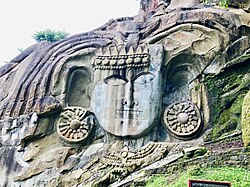 Shiva with the waters of Ganga flowing from his locks
 -
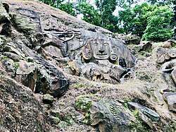 Mahishasurmardini
 -
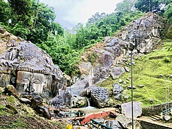 The rock wall
 -
 Shiva
Shiva -


Transport[edit | edit source]
The National Highway 8 (NH 8), running from Karimganj in Assam to Sabroom in Tripura, passes through this district.[6]
The Lumding–Sabroom line of Northeast Frontier Railway passes through Unakoti district. The main train station in district is Kumarghat railway station, providing connectivity to Tripura capital Agartala and Assam, alongside other major cities, such as Dharmanagar, Udaipur and Belonia.[7]
Villages[edit | edit source]
References[edit | edit source]
- ↑ 1.0 1.1 "History | Unakoti District Website | India". Retrieved 25 October 2022.
- ↑ "Feature". Archived from the original on 21 August 2001.
- ↑ "Unakoti District Map".
- ↑ "DISTRICT SURVEY REPORT (UNAKOTI DISTRICT, TRIPURA)" (PDF). Archived from the original (PDF) on 2 December 2021. Retrieved 2 December 2021.
- ↑ "Home | IMD Agartala". agartala.imd.gov.in. Retrieved 25 October 2022.
- ↑ "Rationalisation of Numbering Systems of National Highways" (PDF). New Delhi: Department of Road Transport and Highways. Archived from the original (PDF) on 4 December 2018. Retrieved 3 April 2012.
- ↑ "Kumarghat Railway station, Indian Rail Info".
External links[edit | edit source]
| State symbols | |
|---|---|
| Topics | |
| Government | |
| Districts | |
| Cities and towns | |
| Education | |
| Culture | |

24°14′12″N 92°01′12″E / 24.2366°N 92.0199°E