Ajmer district
Ajmer district
अजमेर जिला | |
|---|---|
Clockwise from top-left: Ajmer Sharif Dargah, Baradaris near Ana Sagar Lake, Hills near Taragarh, Ghats near Pushkar Lake, Akbari Fort | |
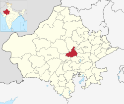
 Location of Ajmer district in Rajasthan | |
| Coordinates (Ajmer): 26°27′N 74°38′E / 26.450°N 74.633°E | |
| Country | |
| State | Rajasthan |
| Division | Ajmer |
| Headquarters | Ajmer |
| Tehsils | 1. Kishangarh, 2. Ajmer, 3. Sarwar, 4. Kekri, 5. Peesangan, 6. Nasirabad, 7. Masuda, 8. Beawar, 9. Bhinay |
| Government | |
| • District collector | Ms. Arti Dogra[1] |
| • Lok Sabha constituencies | 1. Ajmer (shared with Jaipur district), 2. Rajsamand (shared with Nagaur, Pali and Rajsamand districts) |
| • Vidhan Sabha constituencies | 1. Dudu, 2. Ajmer North, 3. Ajmer South, 4. Pushkar, 5. Kisahngarh, 6. Nasirabad, 7. Masuda, 8. Kekri |
| Area | |
| • Total | 8,481 km2 (3,275 sq mi) |
| Population (2011)[2] | |
| • Total | 2,583,052 |
| • Density | 300/km2 (790/sq mi) |
| • Urban | 40.1% |
| Demographics | |
| • Literacy | 69.3% |
| • Sex ratio | 951 |
| Time zone | UTC+05:30 (IST) |
| Vehicle registration | RJ-01 |
| Major highways | NH 48, NH 58, NH 448 |
| Average annual precipitation | 481.3[3] mm |
| Website | ajmer |
Ajmer District is a district of the state of Rajasthan in western India. The city of Ajmer is the district headquarters.
Ajmer District has an area of 8,481 km2, and a population of 2,583,052 (2011 census). There are 1,869,044 Hindus, 244,341 Muslims and 47,812 Jains. The district is situated in the center of Rajasthan, and is bounded by Nagaur district to the north, Jaipur and Tonk districts to the east, Bhilwara district to the south, and Pali district to the west.
History[edit | edit source]
The hills are some of the oldest in India, geologically. Microliths from early hominids have been found in the district. It is believed that cultures in this region had contact with the Indus Valley civilization. Pottery shards from Painted Gray Ware culture, Black and Red Ware and Northern Black Polished Ware cultures have been found with Chosla and Sameliya. Some pre-Ashokan Brahmi inscriptions have been found in Bhilot Mata Temple in Badli.
Pushkar was ruled for many years by the Kushans, Sakas etc until the rise of the Chauhans. In 1192 the last independent Chauhan ruler Prithviraj Chauhan was defeated by Mohammad Ghori, and the district became part of the Delhi Sultanate. In 1287, Hammir Dev Chauhan regained Ajmer, before it was reconquered by Delhi in 1301. In the last period of the Delhi Sultanate, Ajmer was ruled by Mallu Khan. During Mughal rule the district was part of Ajmer Subah. After 1712, the district returned to Rathore hands under the suzereinty of the Marathas. In 1801, the British took over Ajmer and converted it to a district. It became part of Rajasthan after 1950.
Geography[edit | edit source]
The eastern portion of the district is generally flat, broken only by gentle undulations. The western parts, from north-west to south-west, are intersected by the Aravalli Range. Many of the valleys in this region are sandy deserts, part of India's Thar Desert, with an occasional oasis of cultivation. Some fertile tracts are also present; among these is the plain on which lies the town of Ajmer. This valley has an artificial lake, and is protected by the massive walls of the Nagpathar range or Serpent rock, which forms a barrier against the sand. The only hills in the district are the Aravalli Range and its offshoots. Ajmer is almost totally devoid of rivers. The Banas River touches the south-eastern boundary of the district so as to irrigate the pargana of Samur. Four small streams—the Sagarmati, Saraswati, Khari and Dai—also intersect the district.
The district is divided into four subdivisions, Ajmer, Beawar, Kekri and Kishangarh, and further subdivided into nine tehsils, Ajmer, Beawar, Bhinai, Sarwar, Pisangan, Tantoti, Nasirabad, Masuda, Kekri, Kishangarh.
Demographics[edit | edit source]
According to the 2011 census Ajmer district has a population of 2,583,052.[2] This gives it a ranking of 161st in India (out of a total of 640).[2] The district has a population density of 305 inhabitants per square kilometre (790/sq mi) .[2] Its population growth rate over the decade 2001-2011 was 18.48%.[2] Ajmer has a sex ratio of 950 females for every 1000 males,[2] and a literacy rate of 70.46%. Scheduled Castes and Scheduled Tribes make up 478,027 (18.51%) and 63,482 (2.46%) of the population respectively.[2]
Languages[edit | edit source]
Languages in Ajmer district (2011)[5]
| Year | Pop. | ±% p.a. |
|---|---|---|
| 1901 | 527,036 | — |
| 1911 | 543,802 | +0.31% |
| 1921 | 523,585 | −0.38% |
| 1931 | 592,464 | +1.24% |
| 1941 | 680,957 | +1.40% |
| 1951 | 818,767 | +1.86% |
| 1961 | 975,106 | +1.76% |
| 1971 | 1,145,995 | +1.63% |
| 1981 | 1,438,068 | +2.30% |
| 1991 | 1,726,531 | +1.84% |
| 2001 | 2,178,447 | +2.35% |
| 2011 | 2,583,052 | +1.72% |
| source:[6] | ||
References[edit | edit source]
- ↑ "District Administration | Ajmer, Rajasthan Official Website". Retrieved 7 July 2018.
- ↑ 2.0 2.1 2.2 2.3 2.4 2.5 2.6 "District Census Handbook 2011 - Ajmer" (PDF). Census of India. Registrar General and Census Commissioner of India.
- ↑ "Monsoon Report 2016" (PDF). Retrieved 7 July 2018.
- ↑ "Table C-01 Population By Religion - Rajasthan". census.gov.in. Registrar General and Census Commissioner of India.
- ↑ "Table C-16 Population by Mother Tongue: Rajasthan". censusindia.gov.in. Registrar General and Census Commissioner of India.
- ↑ Decadal Variation In Population Since 1901
- Ajmer The Imperial Gazetteer of India, 1909, v. 5, p. 137-146.


