




->Sang00500 →Pilgrimage sites: Added links |
m refined article per standard format and cleaned formatting |
||
| Line 4: | Line 4: | ||
{{Use Indian English|date = September 2019}} | {{Use Indian English|date = September 2019}} | ||
{{Infobox settlement | {{Infobox settlement | ||
| name | | name = Ramgarh district | ||
| settlement_type | | settlement_type = [[List of districts of Jharkhand|District]] of [[Jharkhand]] | ||
| total_type | | total_type = Total | ||
| native_name | | native_name = | ||
| image_skyline | | image_skyline = {{multiple image | ||
| border = infobox | |||
| total_width = 250 | |||
| image_style = | |||
| perrow = 1/2/1 | |||
| image1 = Patratu Valley at night.jpg | |||
| image2 = Patratu dam on cloudy day.jpg | |||
| image3 = District Collectorate, Ramgarh 2.png | |||
| image4 = Chhinnamastika Temple Rajrappa.jpg | |||
| | |||
| | |||
| | |||
| | |||
| | |||
| | |||
| | |||
| | |||
}} | }} | ||
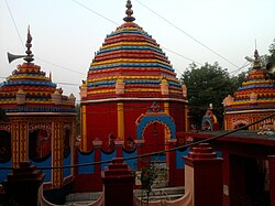
'''Ramgarh district''' is one of the 24 districts in the [[India]]n [[States and territories of India|state]] of [[Jharkhand]]. It was also a military district during the British Regime, referred to then as | | image_caption = Top to bottom: Patratu Valley at night, Patratu Dam, District Collectorate, Ramgarh, [[Chhinnamasta Temple]] | ||
| image_map = Ramgarh in Jharkhand (India).svg | |||
| map_caption = Location of Ramgarh district in Jharkhand | |||
| coordinates = | |||
| coor_pinpoint = Ramgarh Cantonment | |||
| subdivision_type = Country | |||
| subdivision_name = {{flag|India}} | |||
| subdivision_type1 = [[States and union territories of India|State]] | |||
| subdivision_name1 = {{flagicon image|Government banner of Jharkhand.png}} [[Jharkhand]] | |||
| subdivision_type2 = [[Administrative divisions of Jharkhand|Division]] | |||
| subdivision_name2 = [[North Chotanagpur Division|North Chotanagpur]] | |||
| established_title = Established | |||
| established_date = | |||
| seat_type = Headquarters | |||
| seat = [[Ramgarh Cantonment]] | |||
| parts_type = [[Tehsils of India|Tehsils]] | |||
| parts_style = para | |||
| p1 = Ramgarh | |||
| area_total_km2 = 1341 | |||
| area_footnotes = | |||
| population_as_of = 2011 | |||
| population_total = 949,443 | |||
| population_footnotes = | |||
| population_urban = 4,372 | |||
| population_density_km2 = auto | |||
| demographics_type1 = Demographics | |||
| demographics1_title1 = [[Literacy in India|Literacy]] | |||
| demographics1_info1 = 73.17% | |||
| demographics1_title2 = Sex ratio | |||
| demographics1_info2 = 921 | |||
| leader_title = [[District magistrate|Deputy Commissioner]] | |||
| leader_name = Shri Chandan Kumar ([[Indian Administrative Service|IAS]]) | |||
| leader_title1 = [[Lok Sabha|Lok Sabha constituencies]] | |||
| leader_name1 = [[Hazaribagh Lok Sabha constituency|Hazaribagh]] | |||
| leader_title2 = [[Vidhan Sabha|Vidhan Sabha constituencies]] | |||
| leader_name2 = [[Ramgarh (Jharkhand Vidhan Sabha constituency)|Ramgarh]],[[Barkagaon (Vidhan Sabha constituency)|Barkagaon]] | |||
| timezone1 = [[Indian Standard Time|IST]] | |||
| utc_offset1 = +05:30 | |||
| registration_plate = JH-24 | |||
| blank_name_sec1 = [[Roads in India|Major highways]] | |||
| blank_info_sec1 = [[National Highway 20 (India)|NH 20]] and [[NH 23]] | |||
| blank_name_sec2 = | |||
| blank_info_sec2 = | |||
| website = {{URL|https://ramgarh.nic.in/}} | |||
| official_name = | |||
| area_rank = 23 | |||
| population_rank = 24 | |||
}} | |||
'''Ramgarh district''' is one of the 24 districts in the [[India]]n [[States and territories of India|state]] of [[Jharkhand]]. It was also a military district during the British Regime, referred to then as Ramgarh district. It is the part of State Capital Region (SCR). | |||
== | Ramgarh was made a district on 12 September 2007. It was carved out of erstwhile Hazaribagh District. Ramgarh lies at the heart of the Jharkhand state. It is a mining, industrial and cultural hub with the Maa Chhinnamasta Temple.<ref>{{Cite web |url=http://epaper.jagran.com/epaper/26-aug-2012-212-Ranchi-Page-1.html |title=Archived copy |access-date=27 August 2012 |archive-date=30 December 2013 |archive-url=https://web.archive.org/web/20131230233123/http://epaper.jagran.com/epaper/26-aug-2012-212-Ranchi-Page-1.html |url-status=dead }}</ref> In 1670s, the king Dalel Singh shifted the capital of [[Ramgarh Raj]] to Ramgarh and named it after his father Ram Singh. The district of Ramgarh has been named after the town Ramgarh, its present headquarters. | ||
==Etymology== | |||
The word ''Ram'' is derived from ''Murram'' and ''Gadh'' is derived from ''Beluagadha''. In Hazaribagh district, there is Sitagadha and Vishnugadha.{{Clarify|reason=What are these? Needs clarification|date=July 2021}} Thus, the name ''Ramgarh'' must have been derived by using syllables of these places. | |||
''' | |||
==History== | ==History== | ||
{{Prose|section|date=August 2025}} | |||
=== Ancient history === | === Ancient history === | ||
'''Stone age''': Along the river [[Damodar River|Damodar]] in Ramgarh, early Stone Age ([[Lower Paleolithic]]) tools<ref>{{cite web|url=http://www.jharkhandtourism.in/History/hazaribag.htm|title=HistoricJharkhand}}</ref> were found. | '''Stone age''': Along the river [[Damodar River|Damodar]] in Ramgarh, early Stone Age ([[Lower Paleolithic]]) tools<ref>{{cite web|url=http://www.jharkhandtourism.in/History/hazaribag.htm|title=HistoricJharkhand}}</ref> were found. | ||
'''Mahajanapadas:''' The gigantic king [[Jarasandh]] was very powerful. Chotanagpur<ref name="ReferenceA">District gazetteer, hazaribagh chapter IV, page no. – 65</ref> was in his jurisdiction; probably the Chhotanagpur was under sub-ordination of Mahapadam of [[Magadh]] Nand Ugrasen of Nagwanshi's. | '''Mahajanapadas:''' The gigantic king [[Jarasandh]] was very powerful. Chotanagpur<ref name="ReferenceA">District gazetteer, hazaribagh chapter IV, page no. – 65</ref> was in his jurisdiction; probably the Chhotanagpur was under sub-ordination of Mahapadam of [[Magadha (Mahajanapada)|Magadh]] Nand Ugrasen of Nagwanshi's. | ||
'''Maurya Empire''': It is also said that entire Chhotanagpur was under sub-ordination of [[Ashoka]] the Great ({{Circa|273|232}} BC) so that in Buddha period.{{Clarify|reason=poor grammar|date=July 2021}} | '''Maurya Empire''': It is also said that entire Chhotanagpur was under sub-ordination of [[Ashoka]] the Great ({{Circa|273|232}} BC) so that in Buddha period.{{Clarify|reason=poor grammar|date=July 2021}} | ||
| Line 108: | Line 87: | ||
=== Medieval period === | === Medieval period === | ||
In Turk-Afghan period (1206-1526 AD.), Jharkhand the forest country was under subordination of ruler of that time. The [[Ramgarh Raj]] was established in 1368.<ref>District Gazetteer, Hazaribagh, Chapter IV, Page no.- 68</ref> The founder King of Ramgarh regime was King Bagdeo Singh. At that time the capital of Ramgarh was in Sira. The headquarters of the capital was moved to Urda, Badam, Ramgarh and [[Padma]] one by one. In 1670 the headquarters of Ramgarh regime was moved to Ramgarh. The Ramgarh Regime is also known as Padma Raja or Regime.<ref>District Gazetteer, Hazaribagh, Chapter IV, Page no.- 69</ref> | In Turk-Afghan period (1206-1526 AD.), Jharkhand the forest country was under subordination of ruler of that time. The [[Ramgarh Raj]] was established in 1368.<ref>District Gazetteer, Hazaribagh, Chapter IV, Page no.- 68</ref> The founder King of Ramgarh regime was King Bagdeo Singh. At that time the capital of Ramgarh was in Sira. The headquarters of the capital was moved to Urda, Badam, Ramgarh and [[Padma]] one by one. In 1670 the headquarters of Ramgarh regime was moved to Ramgarh. The Ramgarh Regime is also known as Padma Raja or Regime.<ref>District Gazetteer, Hazaribagh, Chapter IV, Page no.- 69</ref> | ||
=== British regime === | === British regime === | ||
[[File:Map of present-day Jharkhand region by Rennell, 1779.jpg|thumb|Greater Ramgarh in the 1770s, map by [[James Rennell]].]] | |||
The power of obtaining reference from Ramgarh regime was given to [[East India Company]] by King [[Shah Alam II]]. | The power of obtaining reference from Ramgarh regime was given to [[East India Company]] by King [[Shah Alam II]]. | ||
In 1771, Captain Comac was made Military Collector of Ramgarh District,<ref>District Gazetteer, Hazaribagh Page no.- 70,</ref> whose headquarters was in [[Chatra]]. The military district of Ramgarh contained Nagpur, [[Palamu]], [[Hazaribagh]], [[Chatra]], [[Giridih]] and [[Kodarma]]. At that the headquarters of Ramgarh Battalion<ref>District Gazetteer, Hazaribagh Chapter IV, Page no.- 72</ref> was [[Hazaribagh]], whose commander was a European. The district name is often spelled "Ramghur" in English documents of the time.<ref>{{cite journal |author=University of Calcutta Department of English |year=1853 |title=The Grand Trunk Road – its Localities |journal=Calcutta Review |volume=21 |issue=41 |pages=170–224 |url=https://books.google.com/books?id=A3tEAQAAMAAJ}} Page 190–191 of the reference describes the location of Ramghur district, revealing it to be the modern Ramgarh.</ref> | In 1771, Captain Comac was made Military Collector of Ramgarh District,<ref>District Gazetteer, Hazaribagh Page no.- 70,</ref> whose headquarters was in [[Chatra, Jharkhand|Chatra]]. The military district of Ramgarh contained Nagpur, [[Palamu district|Palamu]], [[Hazaribagh]], [[Chatra, Jharkhand|Chatra]], [[Giridih]] and [[Kodarma]]. At that the headquarters of Ramgarh Battalion<ref>District Gazetteer, Hazaribagh Chapter IV, Page no.- 72</ref> was [[Hazaribagh]], whose commander was a European. The district name is often spelled "Ramghur" in English documents of the time.<ref>{{cite journal |author=University of Calcutta Department of English |year=1853 |title=The Grand Trunk Road – its Localities |journal=Calcutta Review |volume=21 |issue=41 |pages=170–224 |url=https://books.google.com/books?id=A3tEAQAAMAAJ}} Page 190–191 of the reference describes the location of Ramghur district, revealing it to be the modern Ramgarh.</ref> | ||
In 1811, Ramgarh Battalion was used for suppressing the [[Munda people|Munda]], [[Uraon]] and Tamad Revolt and Kol revolt. In 1837, Ramgarh was a police station for the British government. In 1938, a new G.T. road was built and Banaras road was closed. It is worth mentioning the name of Lubia Manghi. Bainu Manjhi and Arjun Manjhi. In Sitagarh, coffee was grown. The name of Rupu Manjhi is famous in the first national revolt of 1857. | In 1811, Ramgarh Battalion was used for suppressing the [[Munda people|Munda]], [[Oraon people|Uraon]] and Tamad Revolt and Kol revolt. In 1837, Ramgarh was a police station for the British government. In 1938, a new G.T. road was built and Banaras road was closed. It is worth mentioning the name of Lubia Manghi. Bainu Manjhi and Arjun Manjhi. In Sitagarh, coffee was grown. The name of Rupu Manjhi is famous in the first national revolt of 1857. | ||
On 8 January 1856, Sheik Bhikari and Thakur Upraon Singh were hanged on a bunyan tree in Chhuttupalu valley. This valley is also known as lalki Ghaati and that bunyan tree is called ''Phansiyahi bore''.{{Which lang|date=July 2021}} | On 8 January 1856, Sheik Bhikari and Thakur Upraon Singh were hanged on a bunyan tree in Chhuttupalu valley. This valley is also known as lalki Ghaati and that bunyan tree is called ''Phansiyahi bore''.{{Which lang|date=July 2021}} | ||
| Line 124: | Line 101: | ||
[[Ramgarh Cantonment]] council was structured in 1941. There are two Army training centers, [[Sikh Regiment|Sikh Regimental Centre]] (SRC) and [[Punjab Regiment (India)|Punjab Regimental Centre]] (PRC). | [[Ramgarh Cantonment]] council was structured in 1941. There are two Army training centers, [[Sikh Regiment|Sikh Regimental Centre]] (SRC) and [[Punjab Regiment (India)|Punjab Regimental Centre]] (PRC). | ||
[[File:Nehru bajaj sarojini khan azad1940a.jpg|thumb|right| Jawaharlal Nehru, industrialist Jamnalal Bajaj, Sarojini Naidu, Khan Abdul Ghaffar Khan, andMaulana Azad at the 1940 Ramgarh Session of the Indian National Congress]] | [[File:Nehru bajaj sarojini khan azad1940a.jpg|thumb|right| Jawaharlal Nehru, industrialist Jamnalal Bajaj, Sarojini Naidu, Khan Abdul Ghaffar Khan, andMaulana Azad at the 1940 Ramgarh Session of the Indian National Congress]] | ||
In March 1940, INC 53rd Session<ref>{{Cite web|archive-url=https://web.archive.org/web/20090329044757/http://aicc.org.in/new/congress-sessions.php|url=http://aicc.org.in/new/congress-sessions.php|title=All India Congress Committee - AICC|archive-date=29 March 2009|website=aicc.org.in}}</ref><ref name="ReferenceB">Danik jagran Ranchi Page No.14, 2 October 2011</ref> was accomplished under the presidency of [[Abul Kalam Azad|Maulana Abul Qalam Azad]] at Jhanda Chowk, Ramgarh now Ramgarh Cantonment [[Mahatma Gandhi]],<ref>{{Cite web|url=http://www.gandhimedia.org/cgi-bin/gm/gm.cgi?action=view&link=Images/Photographs/Personalities/Mahatma_Gandhi/1940&image=IMPHPEMG|title=Error|website=www.gandhimedia.org}}</ref> [[Jawaharlal Nehru]], [[Sardar Patel]], [[Dr. Rajendra Prasad]], [[Sarojini Naidu]], [[Khan Abdul Ghaffar Khan]], [[Acharya J.B. Kripalani]], Industrialist [[Jamnalal Bajaj]] and other leaders<ref>{{Cite web|url=http://www.mkgandhi-sarvodaya.org/gphotgallery/1933-1948/pages/g7.htm|title=Photo Gallery of Mahatma Gandhi (1933-1948)|website=www.mkgandhi-sarvodaya.org}}</ref> of the Indian freedom movement attended the Ramgarh Session.<ref>{{Cite web|url=http://indianmovements.blogspot.com/2010/01/ramgarh-session-1940.html|title=RAMGARH SESSION-1940}}</ref> Mahatma Gandhi also opened khadi{{Definition needed|date=July 2021}} and village Industries Exhibition at Ramgarh.<ref>{{Cite web|url=http://www.gandhiserve.org/information/chronology_1940/chronology_1940.html|title=Chronology 1940}}</ref> | In March 1940, INC 53rd Session<ref>{{Cite web|archive-url=https://web.archive.org/web/20090329044757/http://aicc.org.in/new/congress-sessions.php|url=http://aicc.org.in/new/congress-sessions.php|title=All India Congress Committee - AICC|archive-date=29 March 2009|website=aicc.org.in}}</ref><ref name="ReferenceB">Danik jagran Ranchi Page No.14, 2 October 2011</ref> was accomplished under the presidency of [[Abul Kalam Azad|Maulana Abul Qalam Azad]] at Jhanda Chowk, Ramgarh now Ramgarh Cantonment [[Mahatma Gandhi]],<ref>{{Cite web|url=http://www.gandhimedia.org/cgi-bin/gm/gm.cgi?action=view&link=Images/Photographs/Personalities/Mahatma_Gandhi/1940&image=IMPHPEMG|title=Error|website=www.gandhimedia.org|access-date=21 August 2012|archive-date=5 March 2016|archive-url=https://web.archive.org/web/20160305002845/http://www.gandhimedia.org/cgi-bin/gm/gm.cgi?action=view&link=Images%2FPhotographs%2FPersonalities%2FMahatma_Gandhi%2F1940&image=IMPHPEMG|url-status=dead}}</ref> [[Jawaharlal Nehru]], [[Sardar Patel]], [[Dr. Rajendra Prasad]], [[Sarojini Naidu]], [[Khan Abdul Ghaffar Khan]], [[Acharya J.B. Kripalani]], Industrialist [[Jamnalal Bajaj]] and other leaders<ref>{{Cite web|url=http://www.mkgandhi-sarvodaya.org/gphotgallery/1933-1948/pages/g7.htm|title=Photo Gallery of Mahatma Gandhi (1933-1948)|website=www.mkgandhi-sarvodaya.org}}</ref> of the Indian freedom movement attended the Ramgarh Session.<ref>{{Cite web|url=http://indianmovements.blogspot.com/2010/01/ramgarh-session-1940.html|title=RAMGARH SESSION-1940}}</ref> Mahatma Gandhi also opened khadi{{Definition needed|date=July 2021}} and village Industries Exhibition at Ramgarh.<ref>{{Cite web|url=http://www.gandhiserve.org/information/chronology_1940/chronology_1940.html|title=Chronology 1940|access-date=20 August 2012|archive-date=22 November 2018|archive-url=https://web.archive.org/web/20181122215617/http://gandhiserve.org/information/chronology_1940/chronology_1940.html|url-status=dead}}</ref> | ||
At that time, under the leadership of Netajee [[Subhas Chandra Bose]], a conference against Samjhauta was also completed. In Ramgarh, Subhsha Chandra Bose was seen as president of All India Forward Block and M.N. Roy was seen as leader of the radical democratic party. | At that time, under the leadership of Netajee [[Subhas Chandra Bose]], a conference against Samjhauta was also completed. In Ramgarh, Subhsha Chandra Bose was seen as president of All India Forward Block and M.N. Roy was seen as leader of the radical democratic party. | ||
| Line 135: | Line 111: | ||
On 13 September 2012, Ramgarh become the first district in the country where payment of government schemes like KCC and Indra Awash was done through UID{{Definition needed|date=July 2021}} or [[Aadhaar|Aadhaar cards]]. | On 13 September 2012, Ramgarh become the first district in the country where payment of government schemes like KCC and Indra Awash was done through UID{{Definition needed|date=July 2021}} or [[Aadhaar|Aadhaar cards]]. | ||
== | == Administration == | ||
Ramgarh district consists of six blocks (or 'mandals'). These include [[Ramgarh (community development block)|Ramgarh]], [[Gola (community development block)|Gola]], [[Mandu (community development block)|Mandu]], [[Patratu (community development block)|Patratu]], [[Chitarpur (community development block)|Chitarpur]], and [[Dulmi (community development block)|Dulmi]] blocks.<ref>{{Cite web|url=https://ramgarh.nic.in/block/|title=Block - District Ramgarh, Government of Jharkhand, India}}</ref> | |||
=== Panchayats and Villages === | |||
See: [[List of villages in Ramgarh district]] | |||
== Geography == | |||
===Physiography=== | ===Physiography=== | ||
The district is a part of Chotanagpur plateau. Important physiographic regions<ref>{{cite web|url=http://www.jharkhandforest.com/files/Hazaribagh_Introduction.pdf|title=Forest Resources Survey, Hazaribagh – 2006 {{!}} Introduction Vol. - 1|date=2006|website=jharkhandforest.com|archive-url=https://web.archive.org/web/20141028111157/http://www.jharkhandforest.com/files/Hazaribagh_Introduction.pdf|archive-date=2014-10-28|url-status=dead|access-date=2017-12-15}}</ref> of the district are [[Damodar River|Damodar]] Trough or Upper Damodar basin or Damodar Valley. The majority of the district falls in the Damodar Valley. Damodar Valley is bounded by [[Hazaribag]] Plateau in north and [[Ranchi]] Plateau in south. Ranchi and Hazaribag plateau is separated by east–west running Damodar Valley. | The district is a part of Chotanagpur plateau. Important physiographic regions<ref>{{cite web|url=http://www.jharkhandforest.com/files/Hazaribagh_Introduction.pdf|title=Forest Resources Survey, Hazaribagh – 2006 {{!}} Introduction Vol. - 1|date=2006|website=jharkhandforest.com|archive-url=https://web.archive.org/web/20141028111157/http://www.jharkhandforest.com/files/Hazaribagh_Introduction.pdf|archive-date=2014-10-28|url-status=dead|access-date=2017-12-15}}</ref> of the district are [[Damodar River|Damodar]] Trough or Upper Damodar basin or Damodar Valley. The majority of the district falls in the Damodar Valley. Damodar Valley is bounded by [[Hazaribag]] Plateau in north and [[Ranchi]] Plateau in south. Ranchi and Hazaribag plateau is separated by east–west running Damodar Valley. | ||
[[File:A View of Ranchi plateau and Damodar Valley.jpg|thumb|left| A View of Ranchi Plateau and Damodar Valley, between Ramgarh and Chutupallu]] | [[File:A View of Ranchi plateau and Damodar Valley.jpg|thumb|left| A View of Ranchi Plateau and Damodar Valley, between Ramgarh and Chutupallu]] | ||
Barka Pahar (Marang Buru)<ref>Survey of India, toposheet No.F45B6, 2009.</ref> {{cvt|1049|m}} high above [[sea level]] located along the Ramgarh-Ranchi border is probably the highest peak, and it also separates the districts. | Barka Pahar (Marang Buru)<ref>Survey of India, toposheet No.F45B6, 2009.</ref> {{cvt|1049|m}} high above [[sea level]] located along the Ramgarh-Ranchi border is probably the highest peak, and it also separates the districts. | ||
===Soils and climate=== | |||
There are mainly two types of soil, red soil and sand loam.{{citation needed|date=November 2019}} | |||
In terms of climate, the area lies in the sub-humid region of Chotanagpur Plateau and has a semi-extreme type of climate. The day temperature rises to around {{Convert|40|C|}} during the summers and drops to around {{Convert|10|C|}} during the winter. | |||
The winter season broadly runs from November to February, the hot season from March to May, and the rainy season from June to October.{{citation needed|date=November 2019}} | |||
===Forests and wildlife=== | |||
The forest area of the district is {{Convert|487.93|km2||abbr=on}}. The district is rich in flora and fauna. The government has planned a deer park in the district.<ref>{{cite news| url=http://www.telegraphindia.com/1120605/jsp/jharkhand/story_15570775.jsp#.UDHWoqllSM8 | archive-url=https://web.archive.org/web/20150924152302/http://www.telegraphindia.com/1120605/jsp/jharkhand/story_15570775.jsp#.UDHWoqllSM8 | url-status=dead | archive-date=24 September 2015 | location=Calcutta, India | work=The Telegraph | title=Deer park in Ramgarh | date=2012-06-05}}</ref> The park will come up on {{cvt|25|acre}} on Gola-Muri Road in Gola block. 30 villages in the district are affected by elephants.<ref>{{cite news|date=2012-03-21|title=Proposal to ward off tuskers in 30 villages in Ramgarh district|work=[[The Times of India]]|url=https://timesofindia.indiatimes.com/city/ranchi/Proposal-to-ward-off-tuskers-in-30-villages-in-Ramgarh-district/articleshow/12359411.cms|url-status=live|archive-url=https://web.archive.org/web/20131230235830/http://articles.timesofindia.indiatimes.com/2012-03-21/ranchi/31219757_1_tuskers-ramgarh-villages|archive-date=2013-12-30}}</ref> | |||
===Rivers and river basins=== | ===Rivers and river basins=== | ||
Damodar is the main river of the district and it also forms a major river basin, comprising a number of tributaries. Important amongst them are: Naikari, Bhervi or Bhera and Bokaro river. | Damodar is the main river of the district and it also forms a major river basin, comprising a number of tributaries. Important amongst them are: Naikari, Bhervi or Bhera and Bokaro river. | ||
[[File:Naikari Dam, Patratu.jpg|thumb|right|Naikari Dam, Patratu]] | [[File:Naikari Dam, Patratu.jpg|thumb|right|Naikari Dam, Patratu]] | ||
| Line 155: | Line 145: | ||
Suwarn Rekha River flow south eastern part of district.<ref name="ReferenceC">Survey of India, toposheet No.F45B11 and 73/E.</ref>{{Clarify|reason=Flows into? Through?|date=July 2021}} Tributaries of Suwarn Rekha River include Kadamgara and Khatgara. | Suwarn Rekha River flow south eastern part of district.<ref name="ReferenceC">Survey of India, toposheet No.F45B11 and 73/E.</ref>{{Clarify|reason=Flows into? Through?|date=July 2021}} Tributaries of Suwarn Rekha River include Kadamgara and Khatgara. | ||
=== | ==Demographics== | ||
{{historical populations | |||
|1901|1,23,154 | |||
|1911|1,34,733 | |||
|1921|1,33,503 | |||
|1931|1,58,638 | |||
|1941|1,83,100 | |||
|1951|2,02,533 | |||
|1961|2,65,261 | |||
|1971|3,62,188 | |||
|1981|5,44,330 | |||
|1991|6,98,081 | |||
|2001|8,39,482 | |||
|2011|9,49,443 | |||
|source=Census of India<ref>{{cite web |title=Table A-02 Decadal Variation in Population Since 1901: Jharkhand |url=https://censusindia.gov.in/nada/index.php/catalog/43353/download/47042/20%20A-2%20Jharkhand.pdf |website=census.gov.in|publisher=[[Registrar General and Census Commissioner of India]]}}</ref>|align=center}} | |||
{{Bar box | |||
|title=Religion in Ramgarh district (2011)<ref name="Religion">{{cite web |title=Table C-01 Population By Religion: Jharkhand|url=https://censusindia.gov.in/nada/index.php/catalog/11377/download/14490/DDW20C-01%20MDDS.XLS|website=census.gov.in|publisher=[[Registrar General and Census Commissioner of India]]}}</ref> | |||
|titlebar=#Fcd116 | |||
|left1=Religion | |||
|right1=Percent | |||
|float=left | |||
|bars= | |||
{{Bar percent|[[Hinduism]]|darkorange|81.55}} | |||
{{Bar percent|[[Islam]]|green|13.59}} | |||
{{Bar percent|[[Sarnaism|Sarna]]|maroon|3.41}} | |||
{{Bar percent|[[Christianity in Jharkhand|Christianity]]|dodgerblue|0.76}} | |||
{{Bar percent|Other or not stated|black|0.27}} | |||
}} | |||
= | |||
[[ | According to the [[2011 census of India|2011 census]], Ramgarh district has a [[Demographics of India|population]] of 949,443,<ref name=districtcensus>{{Cite web |date=2011 |title=District Census Handbook: Ramgarh |url=https://censusindia.gov.in/nada/index.php/catalog/564/download/1904/DH_2011_2016_PART_A_DCHB_RAMGARH.pdf |website=censusindia.gov.in |publisher=[[Registrar General and Census Commissioner of India]]}}</ref> roughly equal to the nation of [[Fiji]]<ref name="cia">{{cite web | author = US Directorate of Intelligence | title = Country Comparison:Population | url = https://www.cia.gov/library/publications/the-world-factbook/rankorder/2119rank.html | access-date = 2011-10-01 | quote = Fiji 883,125 July 2011 est. | archive-date = 27 September 2011 | archive-url = https://web.archive.org/web/20110927165947/https://www.cia.gov/library/publications/the-world-factbook/rankorder/2119rank.html | url-status = dead }}</ref> or the US state of [[Delaware]].<ref>{{cite web | ||
}}</ref> or the US state of [[Delaware]].<ref>{{cite web | |||
|url=http://2010.census.gov/2010census/data/apportionment-pop-text.php | |url=http://2010.census.gov/2010census/data/apportionment-pop-text.php | ||
|title=2010 Resident Population Data | |title=2010 Resident Population Data | ||
| Line 300: | Line 185: | ||
|archive-date=19 October 2013 | |archive-date=19 October 2013 | ||
}}</ref> This gives it a ranking of 459th in India (out of a total of [[Districts of India|640]]).<ref name=districtcensus/> | }}</ref> This gives it a ranking of 459th in India (out of a total of [[Districts of India|640]]).<ref name=districtcensus/> | ||
The district has a population density of {{convert| | The district has a population density of {{convert|708|PD/sqkm|PD/sqmi}}.<ref name=districtcensus/> Its [[Family planning in India|population growth rate]] over the decade 2001-2011 was 13.06%.<ref name=districtcensus/> Ramgarh has a [[human sex ratio|sex ratio]] of 921 [[Women in India|females]] for every 1000 males,<ref name=districtcensus/> and a [[Literacy in India|literacy rate]] of 73.17%. 44.13% of the population lives in urban areas. Scheduled Castes and Scheduled Tribes make up 11.20% and 21.19% of the population respectively.<ref name=districtcensus/> | ||
{{Pie chart | {{Pie chart | ||
|caption= Languages of Ramgarh district | |caption= Languages of Ramgarh district (2011)<ref name="language"/> | ||
|label1 = [[Khortha language|Khortha]] |value1 = 56.63 |color1 = red | |label1 = [[Khortha language|Khortha]] |value1 = 56.63 |color1 = red | ||
|label2 = [[Hindi]] |value2 = 18.2 |color2 = orange | |label2 = [[Hindi]] |value2 = 18.2 |color2 = orange | ||
|label3 = [[Urdu]] |value3 = 8.17 |color3 = green | |label3 = [[Urdu]] |value3 = 8.17 |color3 = green | ||
|label4 = [[Santali language|Santali]] |value4 = | |label4 = [[Santali language|Santali]] |value4 = 3.72 |color4 = darkturquoise | ||
|label5 = [[Bhojpuri language|Bhojpuri]] |value5 = 2.91 |color5 = | |label5 = [[Bhojpuri language|Bhojpuri]] |value5 = 2.91 |color5 = gold | ||
|label6 = [[Magahi language|Magahi]] |value6 = 2.78 |color6 = | |label6 = [[Magahi language|Magahi]] |value6 = 2.78 |color6 = crimson | ||
|label7 = [[Sadri language|Sadri]] |value7 = 1.89 |color7 = | |label7 = [[Sadri language|Sadri]] |value7 = 1.89 |color7 = burlywood | ||
|label8 = [[Bengali language|Bengali]]|value8 = 1.59 |color8 = | |label8 = [[Bengali language|Bengali]]|value8 = 1.59 |color8 = orchid | ||
|label9 = Others |value9 = | |label9 = Others |value9 = 4.11 |color9 = grey | ||
}} | }} | ||
At the time of the [[2011 Census of India]], 56.63% of the population in the district spoke [[Khortha language|Khortha]], 18.2% [[Hindi]], 8.17% [[Urdu]], | |||
At the time of the [[2011 Census of India]], 56.63% of the population in the district spoke [[Khortha language|Khortha]], 18.2% [[Hindi]], 8.17% [[Urdu]], 3.72% [[Santali language|Santali]], 2.91% [[Bhojpuri language|Bhojpuri]], 2.78% [[Magahi language|Magahi]] and 1.59% [[Bengali language|Bengali]] as their first language.<ref name="language">{{Cite web |url=https://censusindia.gov.in/nada/index.php/catalog/10207/download/13319/DDW-C16-STMT-MDDS-2000.XLSX|title=Table C-16 Population by Mother Tongue: Jharkhand|website=censusindia.gov.in|publisher=[[Registrar General and Census Commissioner of India]]}}</ref> | |||
== Transport == | == Transport == | ||
=== Rail === | === Rail === | ||
In 1927, Bengal Nagpur Railway (BNR)<ref>{{Cite web|archive-url=https://web.archive.org/web/20110407154217/http://www.ser.indianrailways.gov.in/view_section.jsp?lang=0&id=0,1,397|title=South Eastern Railway|archive-date=7 April 2011|url=http://www.ser.indianrailways.gov.in/view_section.jsp?lang=0&id=0,1,397|website=www.ser.indianrailways.gov.in}}</ref> opened the {{Convert|72|mi||adj=on}} Chandil-Barkakana section to traffic. The same year, the Central India Coalfields (CIC) Railway opened the Gomoh-Barkakana line. It was extended to Daltonganj in 1929. Later it was extended to Sonnagar on Howrah-Delhi Grand Chord line and one more branch was extended to Singrauli from Garwa Road. | In 1927, Bengal Nagpur Railway (BNR)<ref>{{Cite web|archive-url=https://web.archive.org/web/20110407154217/http://www.ser.indianrailways.gov.in/view_section.jsp?lang=0&id=0,1,397|title=South Eastern Railway|archive-date=7 April 2011|url=http://www.ser.indianrailways.gov.in/view_section.jsp?lang=0&id=0,1,397|website=www.ser.indianrailways.gov.in}}</ref> opened the {{Convert|72|mi||adj=on}} Chandil-Barkakana section to traffic. The same year, the Central India Coalfields (CIC) Railway opened the Gomoh-Barkakana line. It was extended to Daltonganj in 1929. Later it was extended to Sonnagar on Howrah-Delhi Grand Chord line and one more branch was extended to Singrauli from Garwa Road. | ||
At present the district railway network is divided between two zone East Central Railways and South Eastern Railway. | At present the district railway network is divided between two zone East Central Railways and South Eastern Railway. | ||
Ramgarh Cantonment, Mael, Barkipona, Gola Road, Harubera, Sondimra and Barlanga Station come under Ranchi Division of SER.<ref>{{cite web|url=http://www.serranchi.org/about/abt_div.htm |title= | Ramgarh Cantonment, Mael, Barkipona, Gola Road, Harubera, Sondimra and Barlanga Station come under Ranchi Division of SER.<ref>{{cite web|url=http://www.serranchi.org/about/abt_div.htm |title=South Eastern Railway Ranchi | Jharkhand |access-date=2012-04-26 |url-status=dead |archive-url=https://web.archive.org/web/20130530031719/http://www.serranchi.org/about/abt_div.htm |archive-date=30 May 2013 }}</ref> | ||
Ranchi Road, Chainpur, Argada, Barkakana Junction, Bhurkunda, Patratu and Tokisud station come Under Dhanbad Division of ECR. | Ranchi Road, Chainpur, Argada, Barkakana Junction, Bhurkunda, Patratu and Tokisud station come Under Dhanbad Division of ECR. | ||
| Line 344: | Line 216: | ||
==== New rail line project ==== | ==== New rail line project ==== | ||
[[Ranchi]]-Koderma-Tilaiya Junction<ref>{{cite web|url=https://www.youtube.com/watch?v=IPWp8LboNwA |archive-url=https://ghostarchive.org/varchive/youtube/20211215/IPWp8LboNwA |archive-date=2021-12-15 |url-status=live|title=Construction of Barkakana Ranchi new line section 11 06 2017|via=www.youtube.com}}{{cbignore}}</ref> railway station (Bihar) new rail line project<ref>{{cite news| url=http://www.telegraphindia.com/1110119/jsp/jharkhand/story_13462613.jsp | location=Calcutta, India | work=The Telegraph | first=Vishvendu | last=Jaipuriar | title=Off Track | date=2011-01-19}}</ref> of the state passes through the district. The district portion between Sidhwar-Barkakana-Kuju and Mandu is already completed. The distance between Ranchi and Barkakana by train will be reduced by half with the new rail line. Completion of this project will also shorten the distance between<ref>{{cite web|url=https://indiarailinfo.com/station/map/shanki-sani/12343|title=Shanki Railway Station Map/Atlas ECR/East Central Zone - Railway Enquiry|first=Anupam Enosh|last=Sarkar|website=indiarailinfo.com}}</ref> Barkakana, Patna and Delhi. The Bakhtiyarpur–Rajgir line was extended to Tilaiya in 2010. After completion of the line, Barkakana will be connected to Bakhtiyarpur. Rajgir, Biharsharif, etc. Tilaiya Junction railway station is situated near Rajoli of Nawada district of Bihar, not to be confused with Tilaiya, Tilaiya Dam, or Jhumri Tilaiya of Jharkhand. | [[Ranchi]]-Koderma-Tilaiya Junction<ref>{{cite web|url=https://www.youtube.com/watch?v=IPWp8LboNwA |archive-url=https://ghostarchive.org/varchive/youtube/20211215/IPWp8LboNwA |archive-date=2021-12-15 |url-status=live|title=Construction of Barkakana Ranchi new line section 11 06 2017|date=3 July 2017 |via=www.youtube.com}}{{cbignore}}</ref> railway station (Bihar) new rail line project<ref>{{cite news| url=http://www.telegraphindia.com/1110119/jsp/jharkhand/story_13462613.jsp | archive-url=https://web.archive.org/web/20110124004246/http://www.telegraphindia.com/1110119/jsp/jharkhand/story_13462613.jsp | url-status=dead | archive-date=24 January 2011 | location=Calcutta, India | work=The Telegraph | first=Vishvendu | last=Jaipuriar | title=Off Track | date=2011-01-19}}</ref> of the state passes through the district. The district portion between Sidhwar-Barkakana-Kuju and Mandu is already completed. The distance between Ranchi and Barkakana by train will be reduced by half with the new rail line. Completion of this project will also shorten the distance between<ref>{{cite web|url=https://indiarailinfo.com/station/map/shanki-sani/12343|title=Shanki Railway Station Map/Atlas ECR/East Central Zone - Railway Enquiry|first=Anupam Enosh|last=Sarkar|website=indiarailinfo.com}}</ref> Barkakana, Patna and Delhi. The Bakhtiyarpur–Rajgir line was extended to Tilaiya in 2010. After completion of the line, Barkakana will be connected to Bakhtiyarpur. Rajgir, Biharsharif, etc. Tilaiya Junction railway station is situated near Rajoli of Nawada district of Bihar, not to be confused with Tilaiya, Tilaiya Dam, or Jhumri Tilaiya of Jharkhand. | ||
[[File:A View of New Rail Line between Kuju & Mandu.jpg|thumb|right| A view of the new rail line between Kuju and Mandu]] | [[File:A View of New Rail Line between Kuju & Mandu.jpg|thumb|right| A view of the new rail line between Kuju and Mandu]] | ||
| Line 351: | Line 223: | ||
Special passenger train service started<ref>{{Cite web|archive-url=https://web.archive.org/web/20170403015059/https://im22-c75.kxcdn.com/0/2216755/0/d210041038.jpg|url=https://im22-c75.kxcdn.com/0/2216755/0/d210041038.jpg|language=hi|title=गाड़ी सं. 03311/03312 बरकाकाना-सिथवार-बरकाकाना स्पेशल गाड़ी का परिचालन|trans-title=Operation of Train No. 03311/03312 Barkakana-Sithwar-Barkakana Special Train|archive-date=3 April 2017|website=im22-c75.kxcdn.com}}</ref> on 31 March 2017<ref>{{Cite web|archive-url=https://web.archive.org/web/20170403015128/https://im23-c75.kxcdn.com/0/2216337/0/img20170330191603.jpg|title=बरकाकाना-सिधवर नई रेल लाईन पर दिनांक 31.03.2017 से परिचालन प्रारंभ|language=hi|trans-title=On Barkakana-Sidhawar new rail line - Commencement of Operations from 31.03.2017 |url=https://im23-c75.kxcdn.com/0/2216337/0/img20170330191603.jpg|archive-date=3 April 2017|website=im23-c75.kxcdn.com}}</ref> from Barkakana Junction to Sidhwar station of Barkakana–Ranchi new line<ref>{{Cite web|archive-url=https://web.archive.org/web/20170403015339/https://im23-c75.kxcdn.com/0/2216337/0/img20170330191609.jpg|title=Barkakhana - Sidhwar New Line (07 KM)|archive-date=3 April 2017|url=https://im23-c75.kxcdn.com/0/2216337/0/img20170330191609.jpg|website=im23-c75.kxcdn.com}}</ref> section. | Special passenger train service started<ref>{{Cite web|archive-url=https://web.archive.org/web/20170403015059/https://im22-c75.kxcdn.com/0/2216755/0/d210041038.jpg|url=https://im22-c75.kxcdn.com/0/2216755/0/d210041038.jpg|language=hi|title=गाड़ी सं. 03311/03312 बरकाकाना-सिथवार-बरकाकाना स्पेशल गाड़ी का परिचालन|trans-title=Operation of Train No. 03311/03312 Barkakana-Sithwar-Barkakana Special Train|archive-date=3 April 2017|website=im22-c75.kxcdn.com}}</ref> on 31 March 2017<ref>{{Cite web|archive-url=https://web.archive.org/web/20170403015128/https://im23-c75.kxcdn.com/0/2216337/0/img20170330191603.jpg|title=बरकाकाना-सिधवर नई रेल लाईन पर दिनांक 31.03.2017 से परिचालन प्रारंभ|language=hi|trans-title=On Barkakana-Sidhawar new rail line - Commencement of Operations from 31.03.2017 |url=https://im23-c75.kxcdn.com/0/2216337/0/img20170330191603.jpg|archive-date=3 April 2017|website=im23-c75.kxcdn.com}}</ref> from Barkakana Junction to Sidhwar station of Barkakana–Ranchi new line<ref>{{Cite web|archive-url=https://web.archive.org/web/20170403015339/https://im23-c75.kxcdn.com/0/2216337/0/img20170330191609.jpg|title=Barkakhana - Sidhwar New Line (07 KM)|archive-date=3 April 2017|url=https://im23-c75.kxcdn.com/0/2216337/0/img20170330191609.jpg|website=im23-c75.kxcdn.com}}</ref> section. | ||
A trial run of the passenger train between Tatisilwai and Sanki railway stations (31.4 km) on Ranchi Barkakana's new rail line was conducted on 17 January 2018.<ref>{{cite web |url=https://www.livehindustan.com/jharkhand/ramgarh/story-first-train-reached-tatisilwai-from-sanki-in-25-minutes-1753412.html |title=first train reached Tatisilwai from Sanki in 25 minutes - 25 मिनट में सांकी से टाटीसिलवे पहली बार पहुंची ट्रेन |date= |author= |access-date=30 June 2021|language=hi}}</ref> | A trial run of the passenger train between Tatisilwai and Sanki railway stations (31.4 km) on Ranchi Barkakana's new rail line was conducted on 17 January 2018.<ref>{{cite web |url=https://www.livehindustan.com/jharkhand/ramgarh/story-first-train-reached-tatisilwai-from-sanki-in-25-minutes-1753412.html |title=first train reached Tatisilwai from Sanki in 25 minutes - 25 मिनट में सांकी से टाटीसिलवे पहली बार पहुंची ट्रेन |date= 17 January 2018|author= |access-date=30 June 2021|language=hi}}</ref> | ||
The new railway line between Tatisilwai and Sanki was inaugurated by CM Ragubar Das on 29 August 2019. Two new pairs of passenger trains between Hatia and Sanki stations were implemented on 29 August 2019.{{citation needed|date=November 2019}} | The new railway line between Tatisilwai and Sanki was inaugurated by CM Ragubar Das on 29 August 2019. Two new pairs of passenger trains between Hatia and Sanki stations were implemented on 29 August 2019.{{citation needed|date=November 2019}} | ||
=== Roads === | === Roads === | ||
[[File:NH 33 Between Ramgarh and Chutupallu.jpg|thumb|NH | [[File:NH 33 Between Ramgarh and Chutupallu.jpg|thumb|NH 20 Between Ramgarh and Chutupallu]] | ||
[[File:State Highway No.2 between Patratu and Ranchi.jpg|thumb|State Highway No.2 between Patratu and Ranchi]] | [[File:State Highway No.2 between Patratu and Ranchi.jpg|thumb|State Highway No.2 between Patratu and Ranchi]] | ||
Road are the major means of transportation in the district. Three major expressways (NH- | Road are the major means of transportation in the district. Three major expressways (NH-20, NH-23 and SH-2) pass through the district. The State Highways Authority of Jharkhand (SHAJ) is planning to construct a four-lane road between Patratu and Dhanbad<ref>{{Cite web|url=http://epaper.bhaskar.com/ranchi/109/13022013/jarkhand/1/|title=ranchi epaper: ranchi Latest Hindi news ePaper Online - Dainik Bhaskar|access-date=5 March 2013|archive-date=30 December 2013|archive-url=https://web.archive.org/web/20131230234724/http://epaper.bhaskar.com/ranchi/109/13022013/jarkhand/1/|url-status=dead}}</ref> via Sayal, Naya Mor, Chas Mor and Raj Ganj. | ||
'''National highway''' | '''National highway''' | ||
The main national highways<ref>{{Cite web|archive-url=https://web.archive.org/web/20090410034725/http://morth.nic.in/statedetailsmain.asp?state=26|url=http://morth.nic.in/statedetailsmain.asp?state=26|title=Department of Road Transport & Highways|archive-date=10 April 2009|website=morth.nic.in}}</ref> crossing the district are NH- | The main national highways<ref>{{Cite web|archive-url=https://web.archive.org/web/20090410034725/http://morth.nic.in/statedetailsmain.asp?state=26|url=http://morth.nic.in/statedetailsmain.asp?state=26|title=Department of Road Transport & Highways|archive-date=10 April 2009|website=morth.nic.in}}</ref> crossing the district are NH-20 and NH-23. | ||
National Highway 23 connects to NH- | National Highway 23 connects to NH-20 at Mahatma Gandhi Chowk, Ramgarh Cantonment. | ||
State highways serving the area include State Highway No.2.<ref>{{Cite web|archive-url=https://web.archive.org/web/20121030121551/http://www.jharkhand.gov.in/DEPTDOCUPLOAD/uploads/21/D201121122.pdf|url=http://www.jharkhand.gov.in/DEPTDOCUPLOAD/uploads/21/D201121122.pdf|title=State Highways (SH) in Jharkhand|archive-date=30 October 2012|website=www.jharkhand.gov.in}}</ref> | State highways serving the area include State Highway No.2.<ref>{{Cite web|archive-url=https://web.archive.org/web/20121030121551/http://www.jharkhand.gov.in/DEPTDOCUPLOAD/uploads/21/D201121122.pdf|url=http://www.jharkhand.gov.in/DEPTDOCUPLOAD/uploads/21/D201121122.pdf|title=State Highways (SH) in Jharkhand|archive-date=30 October 2012|website=www.jharkhand.gov.in}}</ref> | ||
=== | === Airport === | ||
[[Birsa Munda Airport]] ({{Convert|45|km||abbr=on}}) at Ranchi is the nearest airport. Direct links are available to prominent cities such as [[Delhi]], [[Patna]], [[Mumbai]] and [[Kolkata]]. | |||
== Economy == | |||
The district holds a strong position on the mineral map of the country. The district is endowed with a large and rich deposit of coal and [[coalbed methane]] (CBM) and also possesses various other minerals like [[limestone]] as well as [[fire clay]]. | |||
== | The coalfields of the Ramgarh district lie in the Damodar Valley. The important geological formation of the district is the Gondwana System and the rocks of the Damuda Group of Lower Gondwana age comprises the most important coal seams. The district's coal deposits are mainly found in South Karanpura, West Bokaro and Ramgarh coalfields.<ref>{{cite web|url=http://fossil.energy.gov/international/Publications/Coal_Beneficiation_Workshop/DT_OP_CCL_presentation.pdf |title=WELCOME TO Presentation on|access-date=2019-10-30}}</ref> | ||
=== | === Industries === | ||
Ramgarh is an important industrial district of East India. Several mineral-based industries like steel, sponge iron, cement, refractory and thermal power plants are established due to the availability of coal and other minerals.{{citation needed|date=November 2019}} | |||
=== Agriculture === | |||
The main occupation of the people of Ramgarh is farming. There are three main agricultural seasons in the district: [[Kharif crop|kharif]], [[Rabi crop|rabi]], and [[Zaid crops|zaid]]. Rice, maize, [[Finger millet|ragi]], fruits and vegetables are the main crops<ref>:Page 147, Bihar a physical, Economic and Regional Geography by [[Enayat Ahmad]]</ref> of the district. | |||
== Education == | |||
=== Schools === | |||
* | * Kendriya Vidyalaya :<ref>{{Cite web|archive-url=https://web.archive.org/web/20060318033612/http://www.winentrance.com/Schools/Kendriya/Jharkhand/Default.htm|url=http://www.winentrance.com/Schools/Kendriya/Jharkhand/Default.htm|title=Jharkhand Kendriya Vidyalaya Portal for Education Schools Details CBSE School, entrance exam|archive-date=18 March 2006|website=www.winentrance.com}}</ref> | ||
* D A V Public School:<ref>{{Cite web|archive-url=https://web.archive.org/web/20060318032900/http://www.winentrance.com/Schools/CBSE/Jharkhand/Default.htm|url=http://www.winentrance.com/Schools/CBSE/Jharkhand/Default.htm|title=Jharkhand CBSE Schools, Kendriya Vidyalaya Portal for Education Schools Details CBSE School, entrance exam|archive-date=18 March 2006|website=www.winentrance.com}}</ref> | |||
* Agrasen D. A. V. Public School, Bharech Nagar, Ramgarh. | |||
* Army Public School,<ref>{{cite web|url=http://www.apsramgarhcantt.com/ |title=Army Public School, Ramgarh Cantt |access-date=2012-03-15 |url-status=dead |archive-url=https://web.archive.org/web/20120331102124/http://apsramgarhcantt.com/ |archive-date=31 March 2012 }}</ref> Ramgarh Cantonment. (Army Welfare Education Society) | |||
* D | |||
* D. A. V. Public School, | |||
* Army Public School,<ref>{{cite web|url=http://www.apsramgarhcantt.com/ |title= | |||
=== Colleges === | === Colleges === | ||
* Ramgarh College,<ref>{{cite web|url=http://www.ramgarhcollege.org/|title=Ramgarh College, Ramgarh, Jharkhand - B.Com.Sem-I (Hons) 2016-19 - Electrol Roll 2016}}</ref> Ramgarh<ref>{{cite web|url=http://www.vbu.co.in/website/nonconst_college.html|title=Vinoba Bhave University Hazaribag - Constituent College|website=Vinoba Bhave University|archive-url=https://web.archive.org/web/20130219020730/http://www.vbu.co.in/website/nonconst_college.html|archive-date=2013-02-19|url-status=dead|access-date=2017-12-15}}</ref> | |||
;Engineering colleges | |||
Ramgarh Engineering College opened in 2013. The government is also planning to open Jharkhand state's first women's engineering college in Ramgarh.<ref>{{cite web |url=http://www.jharkhand.gov.in/new_depts/scite/pdf/Five%20Year%20Plan%202012-17.pdf |title=Archived copy |website=www.jharkhand.gov.in |access-date=13 January 2022 |archive-url=https://web.archive.org/web/20121030121701/http://www.jharkhand.gov.in/new_depts/scite/pdf/Five%20Year%20Plan%202012-17.pdf |archive-date=30 October 2012 |url-status=dead}}</ref>{{As of?|date=July 2021}} | |||
;Medical colleges | |||
The government is planning to open a new ESI Medical College<ref>{{Cite web|url=http://epaper.jagran.com/story1.aspx?id=50556&boxid=104370696&ed_date=16-oct-2012&ed_code=212&ed_page=15|title=Story|access-date=16 October 2012|archive-date=3 April 2015|archive-url=https://web.archive.org/web/20150403122745/http://epaper.jagran.com/story1.aspx?id=50556&boxid=104370696&ed_date=16-oct-2012&ed_code=212&ed_page=15|url-status=dead}}</ref> in the district.{{As of?|date=July 2021}} | |||
;Management College | |||
Birsa Institute of Technical Education (B.I.T.E. Ramgarh)<ref>{{Cite web|archive-url=https://web.archive.org/web/20130308044819/http://www.bite.edu.in/about-b-i-t-e/|url=http://www.bite.edu.in/about-b-i-t-e/|title=About B.I.T.E.|archive-date=8 March 2013|website=www.bite.edu.in}}</ref> opened in 2012 in Ramgarh. | Birsa Institute of Technical Education (B.I.T.E. Ramgarh)<ref>{{Cite web|archive-url=https://web.archive.org/web/20130308044819/http://www.bite.edu.in/about-b-i-t-e/|url=http://www.bite.edu.in/about-b-i-t-e/|title=About B.I.T.E.|archive-date=8 March 2013|website=www.bite.edu.in}}</ref> opened in 2012 in Ramgarh. | ||
==Culture and heritage== | |||
== | |||
=== Fairs and festivals === | === Fairs and festivals === | ||
The major and most celebrated fairs and festivals include [[Diwali]], [[Holi]], [[Durga Puja]] or [[Navaratri]], [[Dussehra]], [[Ramanavami]], [[Karam (festival)|Karam]] or Karma, Sarhul, Tusu, Eid, Sarsawati puja, [[Chhath]], Makar Sankranti, and [[Jivitputrika]] or Jitiya ({{langx|hi|जिउतिया}}).<ref>{{Cite web|url=https://www.jagran.com/jharkhand/ramgarh-9737516.html|title=जिउतिया पर माताओं ने रखा उपवास, शाम को की पूजा|website=Dainik Jagran}}</ref> Due to the presence of industry and mining activities, [[Vishwakarma Puja]] is also an important festival. Makar Sankranti fair<ref>{{cite web|url=http://www.onlytravelguide.com/jharkhand/spiritual/rajrappa.php|title=Rajrappa Temple, Ranchi Rajrappa Temple, Tourism on Rajrappa temple, Rajrappa temple in Jharkhand, Rajrappa travel guide, Rajrappa Pilgrimage|website=www.onlytravelguide.com}}</ref> at Rajrappa Mandir also attracts many people. Fairs are also organized during Jitiya,<ref>{{Cite web|url=https://www.jagran.com/jharkhand/ramgarh-here-heading-in-english-for-story8243959-8243959.html|title=तालाटांड में जिउतिया मेला 27 को|website=Dainik Jagran}}</ref> Karma and other festivals. | |||
The major and most celebrated fairs and festivals include [[Diwali]], [[Holi]], [[Durga Puja]] or [[Navaratri]], [[Dussehra]], [[Ramanavami]], [[Karam (festival)|Karam]] or Karma, Sarhul, Tusu, Eid, Sarsawati puja, [[Chhath]], Makar Sankranti, and [[Jivitputrika]] or Jitiya ({{ | |||
=== Cuisine === | === Cuisine === | ||
Ramgarh has a variety of foods and cuisines. The most well-known and common cuisine in Ramgarh includes [[roti]] ([[chapati]]) or ''phulka'', rice or ''bhat'', [[dal]], [[Curry|sabzi]] or [[tarkari]] and [[South Asian pickle|achar]] (South Asian pickles). ''[[Dhooska|Dhuska]]'' and [[Vada (food)|''barra'']] are popular local fast foods. ''Dhuska'' is made from rice and [[Vigna mungo|urad dal]]. ''Barra'' is also prepared using urad dal. Different types of flowers and leaves are used including [[bamboo shoot]]s (''karil''), fried pumpkin flower [[pakora]], ''khukri'' and mushroom ''tarkari''. [[Khoa|Khoya]] [[peda]]s of Rajrappa mandir is also a famous dry sweet. | Ramgarh has a variety of foods and cuisines. The most well-known and common cuisine in Ramgarh includes [[roti]] ([[chapati]]) or ''phulka'', rice or ''bhat'', [[dal]], [[Curry|sabzi]] or [[tarkari]] and [[South Asian pickle|achar]] (South Asian pickles). ''[[Dhooska|Dhuska]]'' and [[Vada (food)|''barra'']] are popular local fast foods. ''Dhuska'' is made from rice and [[Vigna mungo|urad dal]]. ''Barra'' is also prepared using urad dal. Different types of flowers and leaves are used including [[bamboo shoot]]s (''karil''), fried pumpkin flower [[pakora]], ''khukri'' and mushroom ''tarkari''. [[Khoa|Khoya]] [[peda]]s of Rajrappa mandir is also a famous dry sweet. | ||
= | === Places of interest === | ||
{{how-to|section=yes|date=March 2019}} | |||
== Places of interest == | |||
{{ | |||
====Pilgrimage sites==== | |||
* Tooti Jharna Temple: Situated about {{Convert|7|km||abbr=on}} from Ramgarh Cantonment on NH-33 [[Ranchi]]-[[Patna]] highway, is a temple devoted to Lord [[Shiva]] where water from the river falls through a canal on [[Shivalinga]]. The Raghu baba{{Definition needed|date=July 2021}} of this temple is from the nearby village Digwar and hence most of the Digwar villagers are connected to this temple. It is very near Ranchi road, just {{Convert|2-3|km||abbr=on}} ahead towards the way of Village Digwar. | * Tooti Jharna Temple: Situated about {{Convert|7|km||abbr=on}} from Ramgarh Cantonment on NH-33 [[Ranchi]]-[[Patna]] highway, is a temple devoted to Lord [[Shiva]] where water from the river falls through a canal on [[Shivalinga]]. The Raghu baba{{Definition needed|date=July 2021}} of this temple is from the nearby village Digwar and hence most of the Digwar villagers are connected to this temple. It is very near Ranchi road, just {{Convert|2-3|km||abbr=on}} ahead towards the way of Village Digwar. | ||
* Mayatungri Temple: It is also known as Daughter of the Hills and is {{Convert|5|km||abbr=on}} South of Ramgarh in the Chutupalu Valley. Although it is located on a height of {{Convert|300|ft||abbr=on}}, it takes only 15 minutes to march to its peak. Every year the local festival of karma is celebrated here with gaiety and fanfare by the people of the surrounding villages. It is popularly believed that worshipping on the hill brings rain to this area.{{Citation needed|date=July 2021}} Nowadays on the occasion of Durgapuja, Nawratra is performed twice a year on this hill. | * Mayatungri Temple: It is also known as Daughter of the Hills and is {{Convert|5|km||abbr=on}} South of Ramgarh in the Chutupalu Valley. Although it is located on a height of {{Convert|300|ft||abbr=on}}, it takes only 15 minutes to march to its peak. Every year the local festival of karma is celebrated here with gaiety and fanfare by the people of the surrounding villages. It is popularly believed that worshipping on the hill brings rain to this area.{{Citation needed|date=July 2021}} Nowadays on the occasion of Durgapuja, Nawratra is performed twice a year on this hill. | ||
* Kaitha Shiv Mandir:<ref name="auto">{{cite web|url=https://epaper.jagran.com/epaper/|title=Dainik Jagran ePaper: Hindi News Paper, Today Newspaper, Online Hindi Epaper|website=epaper.jagran.com}}</ref> This ancient temple of Shiva is located on NH-23 and is {{Convert|3|km||abbr=on}} away from Ramgarh Cantonment. It has been declared a national monument. The temple was built in 1670. The [[Shivalinga]] in the temple is located at a height which is accessible by means of two stairs. At present this temple is in a dilapidated condition. | * Kaitha Shiv Mandir:<ref name="auto">{{cite web|url=https://epaper.jagran.com/epaper/|archive-url=https://web.archive.org/web/20181114105713/https://epaper.jagran.com/epaper/|url-status=dead|archive-date=14 November 2018|title=Dainik Jagran ePaper: Hindi News Paper, Today Newspaper, Online Hindi Epaper|website=epaper.jagran.com}}</ref> This ancient temple of Shiva is located on NH-23 and is {{Convert|3|km||abbr=on}} away from Ramgarh Cantonment. It has been declared a national monument. The temple was built in 1670. The [[Shivalinga]] in the temple is located at a height which is accessible by means of two stairs. At present this temple is in a dilapidated condition. | ||
* Khere Math: Khere Math temple<ref>{{Cite web|url=http://epaper.jagran.com/story1.aspx?id=57365&boxid=102869672&ed_date=25-jan-2013&ed_code=276&ed_page=9|title=Story}}</ref> of [[Gautama Buddha]] is situated at Matwa-tand village near NH-23 of Gola Block. | * Khere Math: Khere Math temple<ref>{{Cite web|url=http://epaper.jagran.com/story1.aspx?id=57365&boxid=102869672&ed_date=25-jan-2013&ed_code=276&ed_page=9|title=Story|access-date=25 January 2013|archive-date=10 June 2015|archive-url=https://web.archive.org/web/20150610214444/http://epaper.jagran.com/story1.aspx?id=57365&boxid=102869672&ed_date=25-jan-2013&ed_code=276&ed_page=9|url-status=dead}}</ref> of [[Gautama Buddha]] is situated at Matwa-tand village near NH-23 of Gola Block. | ||
* Gurudawara Singh Sabha: This Gurudwara was established and inaugurated by the Sikh community of Ramgarh around 1940 in a small room situated on Shivajee road in Ramgarh. Today a grand structure has taken the form of Gurudwara Sri Guru Singh Sabha in place of that small room. It is the centre of attraction for its great tomb and minarets. The interior decoration of the Darbar hall of Gurudwara Sahib is picture squire.{{Clarify|date=July 2021}} | * Gurudawara Singh Sabha: This Gurudwara was established and inaugurated by the Sikh community of Ramgarh around 1940 in a small room situated on Shivajee road in Ramgarh. Today a grand structure has taken the form of Gurudwara Sri Guru Singh Sabha in place of that small room. It is the centre of attraction for its great tomb and minarets. The interior decoration of the Darbar hall of Gurudwara Sahib is picture squire.{{Clarify|date=July 2021}} | ||
| Line 559: | Line 294: | ||
{{Cleanup lang|section|date=July 2021}}{{Main|Chhinnamasta Temple}} | {{Cleanup lang|section|date=July 2021}}{{Main|Chhinnamasta Temple}} | ||
The Maa Chhinmastika temple (मां छिन्नमस्तिका मंदिर)<ref>[http://astrobix.com/hindudharm/post/chinnamastika-shakti-peeth-rajrappa-shakti-peeth).aspx] {{webarchive|url=https://web.archive.org/web/20120402201545/http://astrobix.com/hindudharm/post/chinnamastika-shakti-peeth-rajrappa-shakti-peeth%29.aspx |date= 2 April 2012 }}</ref> is situated at [[Rajrappa]] (रजरप्पा), {{Convert|28|km||abbr=on}} away from [[Ramgarh Cantonment]] on the confluence of rivers [[Damodar River|Damodar]] and Bhairavi (भैरवी) or Bhera (भेड़ा). This temple is noted in the [[Vedas]] and [[Puranas]] and it has been recognized as an ancient and strong source of [[Shakti]], or divine energy. The Chhinamastika Temple is a place of Hindu pilgrimage. Devotees from all parts of the country visit this holy place throughout the year. The temple is very old and its architectural design is the same as that of other temples of tantrik importance, though its antiquity is yet to be dated. Marriages are also solemnized here on a large scale. The headless statue of the goddess Chhinamastika (छिन्नमस्तिका) stands upon the bodies of [[Kamdeo]] and [[Rati]] in a lotus bed. A number of other temples have come up around the original temple, particularly, the temples of [[Mahavidyas]] (Tara, Shodashi, Bhubneswari, Bhairavi, Bagla, Kamla, Matangi, and Dhumavati) built in a series as well as other temples. These include the [[Sun God]] temple, [[Lord Shiva]] temple, [[Hanuman]] temple, and Ma [[Kali]] temple. In Hindu mythology, Damodar is considered an incarnation of the god Shiva and while Bharvi is the [[Devi|goddess]] Shakti. The confluence of both rivers in Rajrappa is considered a scared union of Damoder (Shiva) and Bharvai (Shakti). The water of the river Bharvi flows down from the top to the river Damoder which flows below, which also shows goddess or ''devi'' power. Many take a dip in the river before offering [[puja (Hinduism)|puja]]. According to the chapter "Ramgarh" from the book ''East India Gazetteer'' by Walter Hamilton, published in 1828, as well as ''Comprehensive History of Bihar'' by Dr. Bindeshwari Prasad Sinha published in 1974, there is no evidence of pilgrimage places like Rajrappa or existence of the Chhinamastika Temple at Rajrappa in the Ramgarh area of undivided Bihar. | The Maa Chhinmastika temple (मां छिन्नमस्तिका मंदिर)<ref>[http://astrobix.com/hindudharm/post/chinnamastika-shakti-peeth-rajrappa-shakti-peeth).aspx] {{webarchive|url=https://web.archive.org/web/20120402201545/http://astrobix.com/hindudharm/post/chinnamastika-shakti-peeth-rajrappa-shakti-peeth%29.aspx|date=2 April 2012}}</ref> is situated at [[Rajrappa]] (रजरप्पा), {{Convert|28|km||abbr=on}} away from [[Ramgarh Cantonment]] on the confluence of rivers [[Damodar River|Damodar]] and Bhairavi (भैरवी) or Bhera (भेड़ा). This temple is noted in the [[Vedas]] and [[Puranas]] and it has been recognized as an ancient and strong source of [[Shakti]], or divine energy. The Chhinamastika Temple is a place of Hindu pilgrimage. Devotees from all parts of the country visit this holy place throughout the year. The temple is very old and its architectural design is the same as that of other temples of tantrik importance, though its antiquity is yet to be dated. Marriages are also solemnized here on a large scale. The headless statue of the goddess Chhinamastika (छिन्नमस्तिका) stands upon the bodies of [[Kamdeo]] and [[Rati]] in a lotus bed. A number of other temples have come up around the original temple, particularly, the temples of [[Mahavidyas]] (Tara, Shodashi, Bhubneswari, Bhairavi, Bagla, Kamla, Matangi, and Dhumavati) built in a series as well as other temples. These include the [[Sun God]] temple, [[Lord Shiva]] temple, [[Hanuman]] temple, and Ma [[Kali]] temple. In Hindu mythology, Damodar is considered an incarnation of the god Shiva and while Bharvi is the [[Devi|goddess]] Shakti. The confluence of both rivers in Rajrappa is considered a scared union of Damoder (Shiva) and Bharvai (Shakti). The water of the river Bharvi flows down from the top to the river Damoder which flows below, which also shows goddess or ''devi'' power. Many take a dip in the river before offering [[puja (Hinduism)|puja]]. According to the chapter "Ramgarh" from the book ''East India Gazetteer'' by Walter Hamilton, published in 1828, as well as ''Comprehensive History of Bihar'' by Dr. Bindeshwari Prasad Sinha published in 1974, there is no evidence of pilgrimage places like Rajrappa or existence of the Chhinamastika Temple at Rajrappa in the Ramgarh area of undivided Bihar. | ||
A hundred years ago,{{As of?|date=July 2021}} the Damodar river was known as Damuda; {{Lang|unr|damu}} means 'sacred' and {{Lang|unr|da}} means 'water' in the [[Mundari language]]. {{Lang|unr|Rajrappa}} means 'the burning place of kings' in Mundari; {{Lang|unr|rappa}} means 'burn'. According to historian G. S. Sardesai, Rajputs from West India came to Bengal in [[Balaji Baji Rao|Peshwa Nana Saheb]]'s train. There was a last clash between Peshwa and [[Raghoji I Bhonsle|Raghuji Bhonshle]] between present-day Gola and the Chitrapur mountain pass of Ramgarh in 1743. Peshwa's advance troops missed their passage to Ramgarh and turned towards the jungle, reaching an area near the confluence of the Bera river near Damuda. The missing unfortunate general was likely the Prince of Jawa (Mewar) [[Karam Singh]] with his troops, and they never joined Peshwa due to the dense forest and unknown mountain pass. Some Rajpoots passed away and were burnt there; later, this wild place was recognised as Rajrappa by Mundari-speaking people. After some years the area became prominent due to the daughter of [[Karam Raja Tusu]]. She became a [[Sati (practice)|sati]] by sacrificing her life in the Rajrappa waterfall after one day of Makar to get rid of Mirza Ramjani, brother of the deceased Mogul Nawab Siraj. After that, there was a tradition of immersing Tusu's idol at Rajrappa on the anniversary of her death. Later on, her soul was worshiped by her men{{Clarify|date=July 2021}} and local people at Rajrappa in a small [[Hindu temple|mandir]] by Sabar priest. Still now the Makar [[Melā|mela]] (fair) is very famous among the local people, but several years ago{{When|date=July 2021}} Tusu's immersion was declined for many reasons described by the natives. Some [[Brahmin|Bramhin]] priests from Medinpur settled near Rajrappa due to the gathering of people and the popularity of the small mandir. Tusu's name was later forgotten and her small mandir was shifted some feet above near the waterfall and converted to Chhinamastika Temple recently.{{When|date=July 2021}} | A hundred years ago,{{As of?|date=July 2021}} the Damodar river was known as Damuda; {{Lang|unr|damu}} means 'sacred' and {{Lang|unr|da}} means 'water' in the [[Mundari language]]. {{Lang|unr|Rajrappa}} means 'the burning place of kings' in Mundari; {{Lang|unr|rappa}} means 'burn'. According to historian G. S. Sardesai, Rajputs from West India came to Bengal in [[Balaji Baji Rao|Peshwa Nana Saheb]]'s train. There was a last clash between Peshwa and [[Raghoji I Bhonsle|Raghuji Bhonshle]] between present-day Gola and the Chitrapur mountain pass of Ramgarh in 1743. Peshwa's advance troops missed their passage to Ramgarh and turned towards the jungle, reaching an area near the confluence of the Bera river near Damuda. The missing unfortunate general was likely the Prince of Jawa (Mewar) [[Karam Singh]] with his troops, and they never joined Peshwa due to the dense forest and unknown mountain pass. Some Rajpoots passed away and were burnt there; later, this wild place was recognised as Rajrappa by Mundari-speaking people. After some years the area became prominent due to the daughter of [[Karam Raja Tusu]]. She became a [[Sati (practice)|sati]] by sacrificing her life in the Rajrappa waterfall after one day of Makar to get rid of Mirza Ramjani, brother of the deceased Mogul Nawab Siraj. After that, there was a tradition of immersing Tusu's idol at Rajrappa on the anniversary of her death. Later on, her soul was worshiped by her men{{Clarify|date=July 2021}} and local people at Rajrappa in a small [[Hindu temple|mandir]] by Sabar priest. Still now the Makar [[Melā|mela]] (fair) is very famous among the local people, but several years ago{{When|date=July 2021}} Tusu's immersion was declined for many reasons described by the natives. Some [[Brahmin|Bramhin]] priests from Medinpur settled near Rajrappa due to the gathering of people and the popularity of the small mandir. Tusu's name was later forgotten and her small mandir was shifted some feet above near the waterfall and converted to Chhinamastika Temple recently.{{When|date=July 2021}} | ||
| Line 569: | Line 304: | ||
[[File:Temples of Mahavidyas built in a series.jpg|thumb|left|Temples of Mahavidyas built in a series]] | [[File:Temples of Mahavidyas built in a series.jpg|thumb|left|Temples of Mahavidyas built in a series]] | ||
[[Rajrappa]] is not only famous for [[ | [[Rajrappa]] is not only famous for [[Shakta pithas|Shakta pitha]] (शाफ्त पीठ, shrines) but is also a [[picnic]] spot. Food, cooking materials, groceries, milk, fruits and fresh vegetables are also available in the market.{{citation needed|date=March 2019}} | ||
One portion of the sand beach by the river Bharvi is prepared for picnics by ''madir samiti''{{Definition needed|date=July 2021}} with the help of a caretaker or agent. They will provide space with Chatai,{{Definition needed|date=July 2021}} table, etc. after paying a nominal charge. During the rainy season the paid sand beach is submerged with water.{{citation needed|date=March 2019}} | One portion of the sand beach by the river Bharvi is prepared for picnics by ''madir samiti''{{Definition needed|date=July 2021}} with the help of a caretaker or agent. They will provide space with Chatai,{{Definition needed|date=July 2021}} table, etc. after paying a nominal charge. During the rainy season the paid sand beach is submerged with water.{{citation needed|date=March 2019}} | ||
[[File:Damodar River (western side)Rajrappa Mandir.jpg|thumb|left|Damodar River (western side) Rajrappa Mandir]] | [[File:Damodar River (western side)Rajrappa Mandir.jpg|thumb|left|Damodar River (western side) Rajrappa Mandir]] | ||
[[File:Damodar River (estern side)Rajrappa Mandir.jpg|thumb|right|Damodar River (eastern side) Rajrappa Mandir]] | [[File:Damodar River (estern side)Rajrappa Mandir.jpg|thumb|right|Damodar River (eastern side) Rajrappa Mandir]] | ||
'''Event''' | '''Event''' | ||
| Line 611: | Line 317: | ||
=== Historic monuments === | === Historic monuments === | ||
'''Mahatama Gandhi Samadhi Sathal''':<ref name="ReferenceB"/> | '''Mahatama Gandhi Samadhi Sathal''':<ref name="ReferenceB"/> | ||
[[File:Mahatma Gandhi Samadhi Ramgarh.jpg|thumb|left| [[Mahatma Gandhi]] Samadhi Sathal, Ramgarh]] | [[File:Mahatma Gandhi Samadhi Ramgarh.jpg|thumb|left| [[Mahatma Gandhi]] Samadhi Sathal, Ramgarh]] | ||
| Line 618: | Line 323: | ||
'''China Cemetery''':<ref name="auto"/> Situated {{Convert|5|km||abbr=on}} away from Ramgarh Cantonment, the China ''Kabristan'' (cemetery) is a famous historical monument. At the outbreak of World War II, some soldiers who rose up against [[Mao Zedong]], the leader of the Chinese [[Cultural Revolution]] and who were also supporters of the friendly states, were captured and imprisoned at Ramgarh. After a few days the soldiers died of hunger and snakebites. A collective burial ground for the soldiers was made; there are a total of 667 graves. In the middle of the graveyard, a pillar in memory of [[Chiang Kai-shek]] was erected. The total area covered by the graveyard is around {{Convert|7|acres|hectare}}. There is a Buddhist temple also in its vicinity. Three cantonments have come into existence around the graveyard.{{citation needed|date=March 2019}} Inside the graveyard the [[Pucca housing|pucca]] roads have been endorsed with rows of flowers. The China ''Kabristan'' is a material witness to the annals of the history of Ramgarh.{{citation needed|date=March 2019}} | '''China Cemetery''':<ref name="auto"/> Situated {{Convert|5|km||abbr=on}} away from Ramgarh Cantonment, the China ''Kabristan'' (cemetery) is a famous historical monument. At the outbreak of World War II, some soldiers who rose up against [[Mao Zedong]], the leader of the Chinese [[Cultural Revolution]] and who were also supporters of the friendly states, were captured and imprisoned at Ramgarh. After a few days the soldiers died of hunger and snakebites. A collective burial ground for the soldiers was made; there are a total of 667 graves. In the middle of the graveyard, a pillar in memory of [[Chiang Kai-shek]] was erected. The total area covered by the graveyard is around {{Convert|7|acres|hectare}}. There is a Buddhist temple also in its vicinity. Three cantonments have come into existence around the graveyard.{{citation needed|date=March 2019}} Inside the graveyard the [[Pucca housing|pucca]] roads have been endorsed with rows of flowers. The China ''Kabristan'' is a material witness to the annals of the history of Ramgarh.{{citation needed|date=March 2019}} | ||
'''Megalithic sites of Ramgarh District''':<ref>{{cite news| url=http://www.telegraphindia.com/1090612/jsp/jharkhand/story_11099740.jsp | location=Calcutta, India | work=The Telegraph | first=Amit | last=Gupta | title=ASI green light to Honhe megalith excavation | date=2009-06-12}}</ref><ref>{{cite news| url=http://www.telegraphindia.com/1090219/jsp/jharkhand/story_10528357.jsp | location=Calcutta, India | work=The Telegraph | first=Vishvendu | last=Jaipuriar | title=Enemy man for heritage sites | date=2009-02-19}}</ref><ref>{{Cite web|archive-url=https://web.archive.org/web/20130922114241/http://intachranchi.com/sitesramgarh.html|url=http://intachranchi.com/sitesramgarh.html|title=Ramgarh|archive-date=22 September 2013|website=intachranchi.com}}</ref> Ramgarh district is very rich in ancient and historical sites. Different [[megalith]] sites have been identified near Chitarpur, Gola and Kuju. | '''Megalithic sites of Ramgarh District''':<ref>{{cite news| url=http://www.telegraphindia.com/1090612/jsp/jharkhand/story_11099740.jsp | archive-url=https://web.archive.org/web/20090616114827/http://www.telegraphindia.com/1090612/jsp/jharkhand/story_11099740.jsp | url-status=dead | archive-date=16 June 2009 | location=Calcutta, India | work=The Telegraph | first=Amit | last=Gupta | title=ASI green light to Honhe megalith excavation | date=2009-06-12}}</ref><ref>{{cite news| url=http://www.telegraphindia.com/1090219/jsp/jharkhand/story_10528357.jsp | archive-url=https://web.archive.org/web/20131227032521/http://www.telegraphindia.com/1090219/jsp/jharkhand/story_10528357.jsp | url-status=dead | archive-date=27 December 2013 | location=Calcutta, India | work=The Telegraph | first=Vishvendu | last=Jaipuriar | title=Enemy man for heritage sites | date=2009-02-19}}</ref><ref>{{Cite web|archive-url=https://web.archive.org/web/20130922114241/http://intachranchi.com/sitesramgarh.html|url=http://intachranchi.com/sitesramgarh.html|title=Ramgarh|archive-date=22 September 2013|website=intachranchi.com}}</ref> Ramgarh district is very rich in ancient and historical sites. Different [[megalith]] sites have been identified near Chitarpur, Gola and Kuju. | ||
=== Nature tourism === | === Nature tourism === | ||
| Line 645: | Line 350: | ||
'''Hundru Fall:''' The Hundru Fall located near the Ranchi-Ramgarh district border is created on the course of the Subarnarekha River.<ref name="ReferenceC"/> | '''Hundru Fall:''' The Hundru Fall located near the Ranchi-Ramgarh district border is created on the course of the Subarnarekha River.<ref name="ReferenceC"/> | ||
==Politics== | |||
[[Lok Sabha]] Constituencies: Hazaribagh<ref name=delimitation2008>{{cite web |url=https://upload.indiacode.nic.in/showfile?actid=AC_CEN_3_20_00030_200233_1517807324510&type=order&filename=Delimitation%20Order,2008.pdf |title=Delimitation of Parliamentary and Assembly Constituencies Order, 2008 |date=26 November 2008 |access-date= 24 June 2021}}</ref> | |||
[[State legislative assemblies of India|Vidhan Sabha]] Constituencies:<ref name=delimitation2008/> | |||
# Ramgarh: Ramgarh Police Station (excluding G.Ps. Terpa, Patratu, Koto, Palani, Hapuhua, Harikarpur, Gegda, Deoria, Bargama, Pali, Salgo, Sanki, Jabo, Chaingari, Chikor, Lapanga, Ghutua, Barkakana and Sidhwar-Kalan) and Gola Police Station. | |||
# Mandu (Part): Mandu Police Stations. | |||
# Barkagaon (Part): G.Ps. Terpa, Patratu, Koto, Palani, Hapuhua, Harijarpu Gegda, Deoria, Bargama, Pali, Salgo, Sanki, Jabo, Chaingara, Chikor, Lapanga, Ghutua, Barkakana and Sidhwar-Kalan in Ramgarh Police Station. | |||
{{transcluded section|source=6th Jharkhand Assembly}} | |||
{{#section:6th Jharkhand Assembly|MLA Header}} | |||
{{#section:6th Jharkhand Assembly|Ramgarh district}} | |||
{{end}} | |||
== See also == | == See also == | ||
* [[Kaitha village]] | * [[Kaitha village]] | ||
* [[List of | * [[List of chief ministers of Jharkhand]] | ||
* [[South Karanpura Coalfield]] | * [[South Karanpura Coalfield]] | ||
Latest revision as of 06:17, 15 March 2026
 | This article has multiple issues. Please help improve it or discuss these issues on the talk page. (Learn how and when to remove these template messages)
Template:Directory
|
Ramgarh district | |
|---|---|
Top to bottom: Patratu Valley at night, Patratu Dam, District Collectorate, Ramgarh, Chhinnamasta Temple | |
.svg) Location of Ramgarh district in Jharkhand | |
| Country |  India India |
| State |  Jharkhand Jharkhand |
| Division | North Chotanagpur |
| Headquarters | Ramgarh Cantonment |
| Tehsils | Ramgarh |
| Government | |
| • Deputy Commissioner | Shri Chandan Kumar (IAS) |
| • Lok Sabha constituencies | Hazaribagh |
| • Vidhan Sabha constituencies | Ramgarh,Barkagaon |
| Area | |
| • Total | 1,341 km2 (518 sq mi) |
| • Rank | 23 |
| Population (2011) | |
| • Total | 949,443 |
| • Rank | 24 |
| • Density | 710/km2 (1,800/sq mi) |
| • Urban | 4,372 |
| Demographics | |
| • Literacy | 73.17% |
| • Sex ratio | 921 |
| Time zone | UTC+05:30 (IST) |
| Vehicle registration | JH-24 |
| Major highways | NH 20 and NH 23 |
| Website | ramgarh |


Ramgarh district is one of the 24 districts in the Indian state of Jharkhand. It was also a military district during the British Regime, referred to then as Ramgarh district. It is the part of State Capital Region (SCR).
Ramgarh was made a district on 12 September 2007. It was carved out of erstwhile Hazaribagh District. Ramgarh lies at the heart of the Jharkhand state. It is a mining, industrial and cultural hub with the Maa Chhinnamasta Temple.[1] In 1670s, the king Dalel Singh shifted the capital of Ramgarh Raj to Ramgarh and named it after his father Ram Singh. The district of Ramgarh has been named after the town Ramgarh, its present headquarters.
Etymology[edit | edit source]
The word Ram is derived from Murram and Gadh is derived from Beluagadha. In Hazaribagh district, there is Sitagadha and Vishnugadha.[clarification needed] Thus, the name Ramgarh must have been derived by using syllables of these places.
History[edit | edit source]
 |
Ancient history[edit | edit source]
Stone age: Along the river Damodar in Ramgarh, early Stone Age (Lower Paleolithic) tools[2] were found.
Mahajanapadas: The gigantic king Jarasandh was very powerful. Chotanagpur[3] was in his jurisdiction; probably the Chhotanagpur was under sub-ordination of Mahapadam of Magadh Nand Ugrasen of Nagwanshi's.
Maurya Empire: It is also said that entire Chhotanagpur was under sub-ordination of Ashoka the Great (c. 273 – c. 232 BC) so that in Buddha period.[clarification needed]
Buddhism and Jainism: It is certified by the symbolic relics of Buddha period in the temple of Gola. Probably in the 8th century BC. (3) Jain Trithankar was constructed in Parasnath.
Gupta Empire: King Samudragupta (c. 385 – c. 380 AD)[3] had invaded Eastern Deccan by passing through this area.
Medieval period[edit | edit source]
In Turk-Afghan period (1206-1526 AD.), Jharkhand the forest country was under subordination of ruler of that time. The Ramgarh Raj was established in 1368.[4] The founder King of Ramgarh regime was King Bagdeo Singh. At that time the capital of Ramgarh was in Sira. The headquarters of the capital was moved to Urda, Badam, Ramgarh and Padma one by one. In 1670 the headquarters of Ramgarh regime was moved to Ramgarh. The Ramgarh Regime is also known as Padma Raja or Regime.[5]
British regime[edit | edit source]

The power of obtaining reference from Ramgarh regime was given to East India Company by King Shah Alam II.
In 1771, Captain Comac was made Military Collector of Ramgarh District,[6] whose headquarters was in Chatra. The military district of Ramgarh contained Nagpur, Palamu, Hazaribagh, Chatra, Giridih and Kodarma. At that the headquarters of Ramgarh Battalion[7] was Hazaribagh, whose commander was a European. The district name is often spelled "Ramghur" in English documents of the time.[8]
In 1811, Ramgarh Battalion was used for suppressing the Munda, Uraon and Tamad Revolt and Kol revolt. In 1837, Ramgarh was a police station for the British government. In 1938, a new G.T. road was built and Banaras road was closed. It is worth mentioning the name of Lubia Manghi. Bainu Manjhi and Arjun Manjhi. In Sitagarh, coffee was grown. The name of Rupu Manjhi is famous in the first national revolt of 1857.
On 8 January 1856, Sheik Bhikari and Thakur Upraon Singh were hanged on a bunyan tree in Chhuttupalu valley. This valley is also known as lalki Ghaati and that bunyan tree is called Phansiyahi bore.[what language is this?]
Ramgarh Cantonment council was structured in 1941. There are two Army training centers, Sikh Regimental Centre (SRC) and Punjab Regimental Centre (PRC).

In March 1940, INC 53rd Session[9][10] was accomplished under the presidency of Maulana Abul Qalam Azad at Jhanda Chowk, Ramgarh now Ramgarh Cantonment Mahatma Gandhi,[11] Jawaharlal Nehru, Sardar Patel, Dr. Rajendra Prasad, Sarojini Naidu, Khan Abdul Ghaffar Khan, Acharya J.B. Kripalani, Industrialist Jamnalal Bajaj and other leaders[12] of the Indian freedom movement attended the Ramgarh Session.[13] Mahatma Gandhi also opened khadi[definition needed] and village Industries Exhibition at Ramgarh.[14]
At that time, under the leadership of Netajee Subhas Chandra Bose, a conference against Samjhauta was also completed. In Ramgarh, Subhsha Chandra Bose was seen as president of All India Forward Block and M.N. Roy was seen as leader of the radical democratic party.
Post-independence[edit | edit source]
After independence in 1947, the territory of the present-day Ramgarh district became a part of erstwhile Hazaribagh district. In 1952 Ramgarh Block was created and in 1991 Ramgarh Subdivision was formed. Sikh Regimental Centre was shifted from Merrut to Ramgarh Cantonment in 1976. On 12 September 2007, Ramgarh was made a district consisting of Ramgarh, Gola, Mandu and Patratu Block, taking the total count of districts in the state to 24.
On 13 September 2012, Ramgarh become the first district in the country where payment of government schemes like KCC and Indra Awash was done through UID[definition needed] or Aadhaar cards.
Administration[edit | edit source]
Ramgarh district consists of six blocks (or 'mandals'). These include Ramgarh, Gola, Mandu, Patratu, Chitarpur, and Dulmi blocks.[15]
Panchayats and Villages[edit | edit source]
See: List of villages in Ramgarh district
Geography[edit | edit source]
Physiography[edit | edit source]
The district is a part of Chotanagpur plateau. Important physiographic regions[16] of the district are Damodar Trough or Upper Damodar basin or Damodar Valley. The majority of the district falls in the Damodar Valley. Damodar Valley is bounded by Hazaribag Plateau in north and Ranchi Plateau in south. Ranchi and Hazaribag plateau is separated by east–west running Damodar Valley.

Barka Pahar (Marang Buru)[17] 1,049 m (3,442 ft) high above sea level located along the Ramgarh-Ranchi border is probably the highest peak, and it also separates the districts.
Soils and climate[edit | edit source]
There are mainly two types of soil, red soil and sand loam.[citation needed]
In terms of climate, the area lies in the sub-humid region of Chotanagpur Plateau and has a semi-extreme type of climate. The day temperature rises to around 40 °C (104 °F) during the summers and drops to around 10 °C (50 °F) during the winter.
The winter season broadly runs from November to February, the hot season from March to May, and the rainy season from June to October.[citation needed]
Forests and wildlife[edit | edit source]
The forest area of the district is 487.93 km2 (188.39 sq mi). The district is rich in flora and fauna. The government has planned a deer park in the district.[18] The park will come up on 25 acres (10 ha) on Gola-Muri Road in Gola block. 30 villages in the district are affected by elephants.[19]
Rivers and river basins[edit | edit source]
Damodar is the main river of the district and it also forms a major river basin, comprising a number of tributaries. Important amongst them are: Naikari, Bhervi or Bhera and Bokaro river.

In Hindu mythology and folklore Damodar is a Nad means Male River.[clarification needed]
Small rivers include the Hurhuri, Gomti, Barki, Kurum, Kochi, Sherbhuki, and Dhobdhab rivers.
Suwarn Rekha River flow south eastern part of district.[20][clarification needed] Tributaries of Suwarn Rekha River include Kadamgara and Khatgara.
Demographics[edit | edit source]
| Year | Pop. | ±% |
|---|---|---|
| 1901 | 123,154 | — |
| 1911 | 134,733 | +9.4% |
| 1921 | 133,503 | −0.9% |
| 1931 | 158,638 | +18.8% |
| 1941 | 183,100 | +15.4% |
| 1951 | 202,533 | +10.6% |
| 1961 | 265,261 | +31.0% |
| 1971 | 362,188 | +36.5% |
| 1981 | 544,330 | +50.3% |
| 1991 | 698,081 | +28.2% |
| 2001 | 839,482 | +20.3% |
| 2011 | 949,443 | +13.1% |
| Source: Census of India[21] | ||
According to the 2011 census, Ramgarh district has a population of 949,443,[23] roughly equal to the nation of Fiji[24] or the US state of Delaware.[25] This gives it a ranking of 459th in India (out of a total of 640).[23] The district has a population density of 708 inhabitants per square kilometre (1,830/sq mi).[23] Its population growth rate over the decade 2001-2011 was 13.06%.[23] Ramgarh has a sex ratio of 921 females for every 1000 males,[23] and a literacy rate of 73.17%. 44.13% of the population lives in urban areas. Scheduled Castes and Scheduled Tribes make up 11.20% and 21.19% of the population respectively.[23]
At the time of the 2011 Census of India, 56.63% of the population in the district spoke Khortha, 18.2% Hindi, 8.17% Urdu, 3.72% Santali, 2.91% Bhojpuri, 2.78% Magahi and 1.59% Bengali as their first language.[26]
Transport[edit | edit source]
Rail[edit | edit source]
In 1927, Bengal Nagpur Railway (BNR)[27] opened the 72-mile (116 km) Chandil-Barkakana section to traffic. The same year, the Central India Coalfields (CIC) Railway opened the Gomoh-Barkakana line. It was extended to Daltonganj in 1929. Later it was extended to Sonnagar on Howrah-Delhi Grand Chord line and one more branch was extended to Singrauli from Garwa Road.
At present the district railway network is divided between two zone East Central Railways and South Eastern Railway.
Ramgarh Cantonment, Mael, Barkipona, Gola Road, Harubera, Sondimra and Barlanga Station come under Ranchi Division of SER.[28]
Ranchi Road, Chainpur, Argada, Barkakana Junction, Bhurkunda, Patratu and Tokisud station come Under Dhanbad Division of ECR.
Barkakana is a railway sub-division under Dhanbad division of East Central Railway zone. Doubling of Danea-Ranchi Road line has announced in the Railway Budget 2013–14.
New rail line project[edit | edit source]
Ranchi-Koderma-Tilaiya Junction[29] railway station (Bihar) new rail line project[30] of the state passes through the district. The district portion between Sidhwar-Barkakana-Kuju and Mandu is already completed. The distance between Ranchi and Barkakana by train will be reduced by half with the new rail line. Completion of this project will also shorten the distance between[31] Barkakana, Patna and Delhi. The Bakhtiyarpur–Rajgir line was extended to Tilaiya in 2010. After completion of the line, Barkakana will be connected to Bakhtiyarpur. Rajgir, Biharsharif, etc. Tilaiya Junction railway station is situated near Rajoli of Nawada district of Bihar, not to be confused with Tilaiya, Tilaiya Dam, or Jhumri Tilaiya of Jharkhand.

The 57 km (35 mi)-long Barkakana-Hazaribagh section of the new Koderma-Ranchi line project was inaugurated on 7 December 2016[32] by Railway Minister Suresh Prabhu in the presence of Chief Minister Raghubar Das.
Special passenger train service started[33] on 31 March 2017[34] from Barkakana Junction to Sidhwar station of Barkakana–Ranchi new line[35] section.
A trial run of the passenger train between Tatisilwai and Sanki railway stations (31.4 km) on Ranchi Barkakana's new rail line was conducted on 17 January 2018.[36]
The new railway line between Tatisilwai and Sanki was inaugurated by CM Ragubar Das on 29 August 2019. Two new pairs of passenger trains between Hatia and Sanki stations were implemented on 29 August 2019.[citation needed]
Roads[edit | edit source]


Road are the major means of transportation in the district. Three major expressways (NH-20, NH-23 and SH-2) pass through the district. The State Highways Authority of Jharkhand (SHAJ) is planning to construct a four-lane road between Patratu and Dhanbad[37] via Sayal, Naya Mor, Chas Mor and Raj Ganj.
National highway
The main national highways[38] crossing the district are NH-20 and NH-23.
National Highway 23 connects to NH-20 at Mahatma Gandhi Chowk, Ramgarh Cantonment.
State highways serving the area include State Highway No.2.[39]
Airport[edit | edit source]
Birsa Munda Airport (45 km (28 mi)) at Ranchi is the nearest airport. Direct links are available to prominent cities such as Delhi, Patna, Mumbai and Kolkata.
Economy[edit | edit source]
The district holds a strong position on the mineral map of the country. The district is endowed with a large and rich deposit of coal and coalbed methane (CBM) and also possesses various other minerals like limestone as well as fire clay.
The coalfields of the Ramgarh district lie in the Damodar Valley. The important geological formation of the district is the Gondwana System and the rocks of the Damuda Group of Lower Gondwana age comprises the most important coal seams. The district's coal deposits are mainly found in South Karanpura, West Bokaro and Ramgarh coalfields.[40]
Industries[edit | edit source]
Ramgarh is an important industrial district of East India. Several mineral-based industries like steel, sponge iron, cement, refractory and thermal power plants are established due to the availability of coal and other minerals.[citation needed]
Agriculture[edit | edit source]
The main occupation of the people of Ramgarh is farming. There are three main agricultural seasons in the district: kharif, rabi, and zaid. Rice, maize, ragi, fruits and vegetables are the main crops[41] of the district.
Education[edit | edit source]
Schools[edit | edit source]
- Kendriya Vidyalaya :[42]
- D A V Public School:[43]
- Agrasen D. A. V. Public School, Bharech Nagar, Ramgarh.
- Army Public School,[44] Ramgarh Cantonment. (Army Welfare Education Society)
Colleges[edit | edit source]
- Engineering colleges
Ramgarh Engineering College opened in 2013. The government is also planning to open Jharkhand state's first women's engineering college in Ramgarh.[47][as of?]
- Medical colleges
The government is planning to open a new ESI Medical College[48] in the district.[as of?]
- Management College
Birsa Institute of Technical Education (B.I.T.E. Ramgarh)[49] opened in 2012 in Ramgarh.
Culture and heritage[edit | edit source]
Fairs and festivals[edit | edit source]
The major and most celebrated fairs and festivals include Diwali, Holi, Durga Puja or Navaratri, Dussehra, Ramanavami, Karam or Karma, Sarhul, Tusu, Eid, Sarsawati puja, Chhath, Makar Sankranti, and Jivitputrika or Jitiya (Hindi: जिउतिया).[50] Due to the presence of industry and mining activities, Vishwakarma Puja is also an important festival. Makar Sankranti fair[51] at Rajrappa Mandir also attracts many people. Fairs are also organized during Jitiya,[52] Karma and other festivals.
Cuisine[edit | edit source]
Ramgarh has a variety of foods and cuisines. The most well-known and common cuisine in Ramgarh includes roti (chapati) or phulka, rice or bhat, dal, sabzi or tarkari and achar (South Asian pickles). Dhuska and barra are popular local fast foods. Dhuska is made from rice and urad dal. Barra is also prepared using urad dal. Different types of flowers and leaves are used including bamboo shoots (karil), fried pumpkin flower pakora, khukri and mushroom tarkari. Khoya pedas of Rajrappa mandir is also a famous dry sweet.
Places of interest[edit | edit source]
| This article contains instructions, advice, or how-to content. (March 2019) |
Pilgrimage sites[edit | edit source]
- Tooti Jharna Temple: Situated about 7 km (4.3 mi) from Ramgarh Cantonment on NH-33 Ranchi-Patna highway, is a temple devoted to Lord Shiva where water from the river falls through a canal on Shivalinga. The Raghu baba[definition needed] of this temple is from the nearby village Digwar and hence most of the Digwar villagers are connected to this temple. It is very near Ranchi road, just 2–3 km (1.2–1.9 mi) ahead towards the way of Village Digwar.
- Mayatungri Temple: It is also known as Daughter of the Hills and is 5 km (3.1 mi) South of Ramgarh in the Chutupalu Valley. Although it is located on a height of 300 ft (91 m), it takes only 15 minutes to march to its peak. Every year the local festival of karma is celebrated here with gaiety and fanfare by the people of the surrounding villages. It is popularly believed that worshipping on the hill brings rain to this area.[citation needed] Nowadays on the occasion of Durgapuja, Nawratra is performed twice a year on this hill.
- Kaitha Shiv Mandir:[53] This ancient temple of Shiva is located on NH-23 and is 3 km (1.9 mi) away from Ramgarh Cantonment. It has been declared a national monument. The temple was built in 1670. The Shivalinga in the temple is located at a height which is accessible by means of two stairs. At present this temple is in a dilapidated condition.
- Khere Math: Khere Math temple[54] of Gautama Buddha is situated at Matwa-tand village near NH-23 of Gola Block.
- Gurudawara Singh Sabha: This Gurudwara was established and inaugurated by the Sikh community of Ramgarh around 1940 in a small room situated on Shivajee road in Ramgarh. Today a grand structure has taken the form of Gurudwara Sri Guru Singh Sabha in place of that small room. It is the centre of attraction for its great tomb and minarets. The interior decoration of the Darbar hall of Gurudwara Sahib is picture squire.[clarification needed]
Rajrappa Mandir[edit | edit source]
| This section should specify the language of its non-English content, using {{lang}}, {{transliteration}} for transliterated languages, and {{IPA}} for phonetic transcriptions, with an appropriate ISO 639 code. Bharatpedia's multilingual support templates may also be used. (July 2021) |
The Maa Chhinmastika temple (मां छिन्नमस्तिका मंदिर)[55] is situated at Rajrappa (रजरप्पा), 28 km (17 mi) away from Ramgarh Cantonment on the confluence of rivers Damodar and Bhairavi (भैरवी) or Bhera (भेड़ा). This temple is noted in the Vedas and Puranas and it has been recognized as an ancient and strong source of Shakti, or divine energy. The Chhinamastika Temple is a place of Hindu pilgrimage. Devotees from all parts of the country visit this holy place throughout the year. The temple is very old and its architectural design is the same as that of other temples of tantrik importance, though its antiquity is yet to be dated. Marriages are also solemnized here on a large scale. The headless statue of the goddess Chhinamastika (छिन्नमस्तिका) stands upon the bodies of Kamdeo and Rati in a lotus bed. A number of other temples have come up around the original temple, particularly, the temples of Mahavidyas (Tara, Shodashi, Bhubneswari, Bhairavi, Bagla, Kamla, Matangi, and Dhumavati) built in a series as well as other temples. These include the Sun God temple, Lord Shiva temple, Hanuman temple, and Ma Kali temple. In Hindu mythology, Damodar is considered an incarnation of the god Shiva and while Bharvi is the goddess Shakti. The confluence of both rivers in Rajrappa is considered a scared union of Damoder (Shiva) and Bharvai (Shakti). The water of the river Bharvi flows down from the top to the river Damoder which flows below, which also shows goddess or devi power. Many take a dip in the river before offering puja. According to the chapter "Ramgarh" from the book East India Gazetteer by Walter Hamilton, published in 1828, as well as Comprehensive History of Bihar by Dr. Bindeshwari Prasad Sinha published in 1974, there is no evidence of pilgrimage places like Rajrappa or existence of the Chhinamastika Temple at Rajrappa in the Ramgarh area of undivided Bihar.
A hundred years ago,[as of?] the Damodar river was known as Damuda; damu means 'sacred' and da means 'water' in the Mundari language. Rajrappa means 'the burning place of kings' in Mundari; rappa means 'burn'. According to historian G. S. Sardesai, Rajputs from West India came to Bengal in Peshwa Nana Saheb's train. There was a last clash between Peshwa and Raghuji Bhonshle between present-day Gola and the Chitrapur mountain pass of Ramgarh in 1743. Peshwa's advance troops missed their passage to Ramgarh and turned towards the jungle, reaching an area near the confluence of the Bera river near Damuda. The missing unfortunate general was likely the Prince of Jawa (Mewar) Karam Singh with his troops, and they never joined Peshwa due to the dense forest and unknown mountain pass. Some Rajpoots passed away and were burnt there; later, this wild place was recognised as Rajrappa by Mundari-speaking people. After some years the area became prominent due to the daughter of Karam Raja Tusu. She became a sati by sacrificing her life in the Rajrappa waterfall after one day of Makar to get rid of Mirza Ramjani, brother of the deceased Mogul Nawab Siraj. After that, there was a tradition of immersing Tusu's idol at Rajrappa on the anniversary of her death. Later on, her soul was worshiped by her men[clarification needed] and local people at Rajrappa in a small mandir by Sabar priest. Still now the Makar mela (fair) is very famous among the local people, but several years ago[when?] Tusu's immersion was declined for many reasons described by the natives. Some Bramhin priests from Medinpur settled near Rajrappa due to the gathering of people and the popularity of the small mandir. Tusu's name was later forgotten and her small mandir was shifted some feet above near the waterfall and converted to Chhinamastika Temple recently.[when?]


Rajrappa is not only famous for Shakta pitha (शाफ्त पीठ, shrines) but is also a picnic spot. Food, cooking materials, groceries, milk, fruits and fresh vegetables are also available in the market.[citation needed] One portion of the sand beach by the river Bharvi is prepared for picnics by madir samiti[definition needed] with the help of a caretaker or agent. They will provide space with Chatai,[definition needed] table, etc. after paying a nominal charge. During the rainy season the paid sand beach is submerged with water.[citation needed]
Rajrappa_Mandir.jpg)
Rajrappa_Mandir.jpg)
Event
Rajrappa Mohatsav:

The two-day grand Rajrappa Mahatsav is a tourism event organized for the promotion of the historic Rajrappa Temple of Jharkhand. With the joint efforts of Ramgarh District Administration, Central Coalfields Limited (CCL) authorities, CSR of corporate houses and Chinamastika Temple Administration, it was marked as a huge success on the first attempt. Many renowned artists including Abhijit Bhatacharya, Pooja Gaitonde, Chetan Joshi, Padamshree Mukund Nayak, Megha Dalton, and Bharat Sharma performed during the Mohatsav. The event was held for the first time on 25 and 26 February 2017.
Historic monuments[edit | edit source]
Mahatama Gandhi Samadhi Sathal:[10]

This sthal popularly known as Gandhi Ghat is situated on the bank of river Damodar in Ramgarh. Mohandas K. Gandhi had visited[56] Ramgarh in 1940 at the time of the Indian National Congress session at Ramgarh. After the assassination of Mahatma Gandhi in 1948, the pitcher containing the remains of the departed were dispatched to different places of the country including Ramgarh. A samadhi of Gandhiji was erected on it. Earlier, a fair used to be organized here on the occasion of the birthday and anniversary of Bapu[definition needed] but now this practice has been abandoned. The samadhi is made of black granite stones.
China Cemetery:[53] Situated 5 km (3.1 mi) away from Ramgarh Cantonment, the China Kabristan (cemetery) is a famous historical monument. At the outbreak of World War II, some soldiers who rose up against Mao Zedong, the leader of the Chinese Cultural Revolution and who were also supporters of the friendly states, were captured and imprisoned at Ramgarh. After a few days the soldiers died of hunger and snakebites. A collective burial ground for the soldiers was made; there are a total of 667 graves. In the middle of the graveyard, a pillar in memory of Chiang Kai-shek was erected. The total area covered by the graveyard is around 7 acres (2.8 hectares). There is a Buddhist temple also in its vicinity. Three cantonments have come into existence around the graveyard.[citation needed] Inside the graveyard the pucca roads have been endorsed with rows of flowers. The China Kabristan is a material witness to the annals of the history of Ramgarh.[citation needed]
Megalithic sites of Ramgarh District:[57][58][59] Ramgarh district is very rich in ancient and historical sites. Different megalith sites have been identified near Chitarpur, Gola and Kuju.
Nature tourism[edit | edit source]

_dam.jpg)

Patratu Dam or Nalkari Dam: Constructed on Nalkari and other small rivers; it is around 5 km (3.1 mi) from Patratu. Surrounded by hills, forest and rivers, Nalkari dam is used for picnicking and boating.[60] The dam was constructed with the purpose of supplying water to Patratu Thermal Power Station. The total storage capacity of this dam is 81 square miles.[61] Boating began on 14 January 2010 on the dam. Patratu dam is located 28 km from Ramgarh Cantonment and 35 km from Ranchi.
Dhur-duria Fall: Dhur-duria Fall is situated near Sidhwar village, about 4 km (2.5 mi) from Ramgarh Cantonment. The fall is created on the course of Sherbhuki river. The road only goes up to Sidhwar village, so an approach road should be constructed from Sidhwar village to fall.[citation needed] The water falls from approximately 50 ft (15 m) height.[62]
Am-Jharia Fall: Situated near the border of Halwadi and Sidhwar village.[62]
Nimi Fall: Nimi Fall is situated near Nimi village and around 5 km (3.1 mi) from Bhurkunda.
Dhara Fall: Dhara Fall is situated near Khakara village under Gola Block. The government is planning to construct an approach road from NH-23 (between Gola and Peterwar) to the fall.[63]
Gandhaunia (Hindi: गंधौनिया (गरम पानी कुंड)): Situated at about 20 km (12 mi). near Mandu.[clarification needed] It is a hot water spring (pond).[64]
Chutupallu: Situated about 10 km (6.2 mi) from Ramgarh on the Ramgarh - Ranchi NH 33 is a hill top with many dhabas (roadside eateries) and motels in the way after crossing Chutupallu that offer food.[citation needed]
Bankhetta: Situated near Chutupallu. Water falls from a height giving the feeling of rainfall in a cave when someone claps inside.
Liril Fall: Situated between Ramgarh and Chutupallu, it looks like the fall from the old Liril soap advertisement. It is popularly known as Liril Fall.
Barso Paani: Situated at about 30 km (19 mi) from Ramgarh, near Charhi towards Hazaribagh. Water falls from the ceiling, giving the feeling of rainfall in a cave when someone claps.
Hundru Fall: The Hundru Fall located near the Ranchi-Ramgarh district border is created on the course of the Subarnarekha River.[20]
Politics[edit | edit source]
Lok Sabha Constituencies: Hazaribagh[65] Vidhan Sabha Constituencies:[65]
- Ramgarh: Ramgarh Police Station (excluding G.Ps. Terpa, Patratu, Koto, Palani, Hapuhua, Harikarpur, Gegda, Deoria, Bargama, Pali, Salgo, Sanki, Jabo, Chaingari, Chikor, Lapanga, Ghutua, Barkakana and Sidhwar-Kalan) and Gola Police Station.
- Mandu (Part): Mandu Police Stations.
- Barkagaon (Part): G.Ps. Terpa, Patratu, Koto, Palani, Hapuhua, Harijarpu Gegda, Deoria, Bargama, Pali, Salgo, Sanki, Jabo, Chaingara, Chikor, Lapanga, Ghutua, Barkakana and Sidhwar-Kalan in Ramgarh Police Station.
| District | No. | Constituency | Name | Party | Alliance | Remarks | Ramgarh | 22 | Barkagaon | Roshan Lal Choudhary | |||
|---|---|---|---|---|---|---|---|---|---|---|---|---|---|
| 23 | Ramgarh | Mamta Devi | INC | Mahagathbandhan | |||||||||
See also[edit | edit source]
References[edit | edit source]
- ↑ "Archived copy". Archived from the original on 30 December 2013. Retrieved 27 August 2012.
{{cite web}}: CS1 maint: archived copy as title (link) - ↑ "HistoricJharkhand".
- ↑ 3.0 3.1 District gazetteer, hazaribagh chapter IV, page no. – 65
- ↑ District Gazetteer, Hazaribagh, Chapter IV, Page no.- 68
- ↑ District Gazetteer, Hazaribagh, Chapter IV, Page no.- 69
- ↑ District Gazetteer, Hazaribagh Page no.- 70,
- ↑ District Gazetteer, Hazaribagh Chapter IV, Page no.- 72
- ↑ University of Calcutta Department of English (1853). "The Grand Trunk Road – its Localities". Calcutta Review. 21 (41): 170–224. Page 190–191 of the reference describes the location of Ramghur district, revealing it to be the modern Ramgarh.
- ↑ "All India Congress Committee - AICC". aicc.org.in. Archived from the original on 29 March 2009.
- ↑ 10.0 10.1 Danik jagran Ranchi Page No.14, 2 October 2011
- ↑ "Error". www.gandhimedia.org. Archived from the original on 5 March 2016. Retrieved 21 August 2012.
- ↑ "Photo Gallery of Mahatma Gandhi (1933-1948)". www.mkgandhi-sarvodaya.org.
- ↑ "RAMGARH SESSION-1940".
- ↑ "Chronology 1940". Archived from the original on 22 November 2018. Retrieved 20 August 2012.
- ↑ "Block - District Ramgarh, Government of Jharkhand, India".
- ↑ "Forest Resources Survey, Hazaribagh – 2006 | Introduction Vol. - 1" (PDF). jharkhandforest.com. 2006. Archived from the original (PDF) on 28 October 2014. Retrieved 15 December 2017.
- ↑ Survey of India, toposheet No.F45B6, 2009.
- ↑ "Deer park in Ramgarh". The Telegraph. Calcutta, India. 5 June 2012. Archived from the original on 24 September 2015.
- ↑ "Proposal to ward off tuskers in 30 villages in Ramgarh district". The Times of India. 21 March 2012. Archived from the original on 30 December 2013.
- ↑ 20.0 20.1 Survey of India, toposheet No.F45B11 and 73/E.
- ↑ "Table A-02 Decadal Variation in Population Since 1901: Jharkhand" (PDF). census.gov.in. Registrar General and Census Commissioner of India.
- ↑ "Table C-01 Population By Religion: Jharkhand". census.gov.in. Registrar General and Census Commissioner of India.
- ↑ 23.0 23.1 23.2 23.3 23.4 23.5 "District Census Handbook: Ramgarh" (PDF). censusindia.gov.in. Registrar General and Census Commissioner of India. 2011.
- ↑ US Directorate of Intelligence. "Country Comparison:Population". Archived from the original on 27 September 2011. Retrieved 1 October 2011.
Fiji 883,125 July 2011 est.
- ↑ "2010 Resident Population Data". U. S. Census Bureau. Archived from the original on 19 October 2013. Retrieved 30 September 2011.
Delaware 897,934
- ↑ 26.0 26.1 "Table C-16 Population by Mother Tongue: Jharkhand". censusindia.gov.in. Registrar General and Census Commissioner of India.
- ↑ "South Eastern Railway". www.ser.indianrailways.gov.in. Archived from the original on 7 April 2011.
- ↑ "South Eastern Railway Ranchi | Jharkhand". Archived from the original on 30 May 2013. Retrieved 26 April 2012.
- ↑ "Construction of Barkakana Ranchi new line section 11 06 2017". 3 July 2017. Archived from the original on 15 December 2021 – via www.youtube.com.
- ↑ Jaipuriar, Vishvendu (19 January 2011). "Off Track". The Telegraph. Calcutta, India. Archived from the original on 24 January 2011.
- ↑ Sarkar, Anupam Enosh. "Shanki Railway Station Map/Atlas ECR/East Central Zone - Railway Enquiry". indiarailinfo.com.
- ↑ "Minister of Railways in the presence of Chief Minister of Jharkhand inaugurates Hazaribagh-Barkakana section of Koderma Ranchi New Railway Line Project".
- ↑ "गाड़ी सं. 03311/03312 बरकाकाना-सिथवार-बरकाकाना स्पेशल गाड़ी का परिचालन" [Operation of Train No. 03311/03312 Barkakana-Sithwar-Barkakana Special Train]. im22-c75.kxcdn.com (in हिन्दी). Archived from the original on 3 April 2017.
- ↑ "बरकाकाना-सिधवर नई रेल लाईन पर दिनांक 31.03.2017 से परिचालन प्रारंभ" [On Barkakana-Sidhawar new rail line - Commencement of Operations from 31.03.2017]. im23-c75.kxcdn.com (in हिन्दी). Archived from the original on 3 April 2017.
- ↑ "Barkakhana - Sidhwar New Line (07 KM)". im23-c75.kxcdn.com. Archived from the original on 3 April 2017.
- ↑ "first train reached Tatisilwai from Sanki in 25 minutes - 25 मिनट में सांकी से टाटीसिलवे पहली बार पहुंची ट्रेन" (in हिन्दी). 17 January 2018. Retrieved 30 June 2021.
- ↑ "ranchi epaper: ranchi Latest Hindi news ePaper Online - Dainik Bhaskar". Archived from the original on 30 December 2013. Retrieved 5 March 2013.
- ↑ "Department of Road Transport & Highways". morth.nic.in. Archived from the original on 10 April 2009.
- ↑ "State Highways (SH) in Jharkhand" (PDF). www.jharkhand.gov.in. Archived from the original (PDF) on 30 October 2012.
- ↑ "WELCOME TO Presentation on" (PDF). Retrieved 30 October 2019.
- ↑ :Page 147, Bihar a physical, Economic and Regional Geography by Enayat Ahmad
- ↑ "Jharkhand Kendriya Vidyalaya Portal for Education Schools Details CBSE School, entrance exam". www.winentrance.com. Archived from the original on 18 March 2006.
- ↑ "Jharkhand CBSE Schools, Kendriya Vidyalaya Portal for Education Schools Details CBSE School, entrance exam". www.winentrance.com. Archived from the original on 18 March 2006.
- ↑ "Army Public School, Ramgarh Cantt". Archived from the original on 31 March 2012. Retrieved 15 March 2012.
- ↑ "Ramgarh College, Ramgarh, Jharkhand - B.Com.Sem-I (Hons) 2016-19 - Electrol Roll 2016".
- ↑ "Vinoba Bhave University Hazaribag - Constituent College". Vinoba Bhave University. Archived from the original on 19 February 2013. Retrieved 15 December 2017.
- ↑ "Archived copy" (PDF). www.jharkhand.gov.in. Archived from the original (PDF) on 30 October 2012. Retrieved 13 January 2022.
{{cite web}}: CS1 maint: archived copy as title (link) - ↑ "Story". Archived from the original on 3 April 2015. Retrieved 16 October 2012.
- ↑ "About B.I.T.E." www.bite.edu.in. Archived from the original on 8 March 2013.
- ↑ "जिउतिया पर माताओं ने रखा उपवास, शाम को की पूजा". Dainik Jagran.
- ↑ "Rajrappa Temple, Ranchi Rajrappa Temple, Tourism on Rajrappa temple, Rajrappa temple in Jharkhand, Rajrappa travel guide, Rajrappa Pilgrimage". www.onlytravelguide.com.
- ↑ "तालाटांड में जिउतिया मेला 27 को". Dainik Jagran.
- ↑ 53.0 53.1 "Dainik Jagran ePaper: Hindi News Paper, Today Newspaper, Online Hindi Epaper". epaper.jagran.com. Archived from the original on 14 November 2018.
- ↑ "Story". Archived from the original on 10 June 2015. Retrieved 25 January 2013.
- ↑ [1] Archived 2 April 2012 at the Wayback Machine
- ↑ "Photo Gallery of Mahatma Gandhi (1933-1948)". www.mkgandhi-sarvodaya.org.
- ↑ Gupta, Amit (12 June 2009). "ASI green light to Honhe megalith excavation". The Telegraph. Calcutta, India. Archived from the original on 16 June 2009.
- ↑ Jaipuriar, Vishvendu (19 February 2009). "Enemy man for heritage sites". The Telegraph. Calcutta, India. Archived from the original on 27 December 2013.
- ↑ "Ramgarh". intachranchi.com. Archived from the original on 22 September 2013.
- ↑ "पीटीपीएस डैम भी स्वागत को तैयार". Dainik Jagran.
- ↑ "Patratu Dam | District Ramgarh, Government of Jharkhand | India".
- ↑ 62.0 62.1 "खास है सिद्धवार का धुरधुरिया झरना". Dainik Jagran.
- ↑ "धारा फॉल स्थल का होगा विकास : सिंह". Dainik Jagran.
- ↑ "गंझुनिया गर्म कुंड में भी पहुंच रहे लोग". Dainik Jagran.
- ↑ 65.0 65.1 "Delimitation of Parliamentary and Assembly Constituencies Order, 2008" (PDF). 26 November 2008. Retrieved 24 June 2021.
External links[edit | edit source]
Places adjacent to Ramgarh district | ||||||||||
|---|---|---|---|---|---|---|---|---|---|---|
| ||||||||||


