


->Kautilya3 →Military posts and infrastructure: Copyedit (minor) |
refined layout for consistency |
||
| Line 2: | Line 2: | ||
{{Use dmy dates|date=December 2020}} | {{Use dmy dates|date=December 2020}} | ||
{{Infobox mountain pass | {{Infobox mountain pass | ||
| name = Kongka | | name = Kongka Pass | ||
| | | native_name = {{langx|bo|དགུན་ཁ་ལ}} | ||
| map = | | map = India Ladakh#China Xinjiang Southern#China Tibet Ngari | ||
| map_relief = 0 | | map_relief = 0 | ||
| | | label_position = top | ||
| photo = | | photo = | ||
| photo_caption = | | photo_caption = | ||
| Line 24: | Line 24: | ||
|t={{linktext|空喀|山口}} | |t={{linktext|空喀|山口}} | ||
|p=Kōngkā shānkǒu | |p=Kōngkā shānkǒu | ||
|tib=དགུན་ཁ་ལ | <!-- |tib=དགུན་ཁ་ལ --> | ||
|wylie=dgun kha la | <!-- |wylie=dgun kha la --> | ||
|zwpy=günka la | <!-- |zwpy=günka la --> | ||
}} | }} | ||
The '''Kongka Pass''' or '''Kongka La''' ({{bo|t=དགུན་ཁ་ལ|w=dgun kha la|s=gün kha la}}<ref>{{Cite web | The '''Kongka Pass''' or '''Kongka La''' ({{bo|t=དགུན་ཁ་ལ|w=dgun kha la|s=gün kha la}}<ref name=KNAB>{{Cite web | ||
| title = Ngari prefecture | | title = Ngari prefecture | ||
| url = https://www.eki.ee/knab/valik/cn54ng.htm | | url = https://www.eki.ee/knab/valik/cn54ng.htm | ||
| Line 36: | Line 36: | ||
| date = 2018-06-03 | | date = 2018-06-03 | ||
| access-date = 9 January 2020 | | access-date = 9 January 2020 | ||
}}</ref>) is a low [[mountain pass]] on the [[Line of Actual Control]] between India and China in eastern [[Ladakh]]. It lies on a spur of the [[Karakoram]] range that intrudes into the [[Chang Chenmo Valley]] adjacent to the disputed [[Aksai Chin]] region. China claimed the location as its border in a 1956 map, and attacked an | }}</ref>) is a low [[mountain pass]] on the [[Line of Actual Control]] between India and China in eastern [[Ladakh]]. It lies on a spur of the [[Karakoram]] range that intrudes into the [[Chang Chenmo Valley]] adjacent to the disputed [[Aksai Chin]] region. China claimed the location as its border in a 1956 map, and attacked an Indian patrol party in 1959 killing ten policemen and apprehending ten others. Known as the '''Kongka Pass incident''', the event was a milestone in the escalation of the border dispute between the two countries.{{sfnp|Hoffmann, Perceived Hostility and the Indian Reaction|1973}} | ||
== | ==Name== | ||
[[File:Changchenmo-Valley-map-Survey-of-India-1916.jpg|thumb| | In the Ladakhi language, Kongka ({{bo|t=གོང་ཀ|w=gong ka}}) means a "low pass or ridge, high point or rise of a plateau".<ref>{{citation |title=RangSkat Ladakhi Dictionary: Ladakhi-English dictionary |author=SECMOL |date=7 May 2020 |url=https://steprimo.com/android/us/app/com.prakshas.rangskat1/RangSkat-Ladakhi-Dictionary/}}</ref> In the first reference we have of this pass, it was called "Salmu Kongka" and explained as a "small pass".<ref name="Carey and Dalgleish"> | ||
[[File:Changchenmo-Valley-map-by-US-Army-Map-Service.jpg|thumb| | {{citation |chapter=Journey of Carey and Dalgleish in Chinese Turkistan and Northern Tibet and General Prejevalsky on the Orography of Northern Tibet |title=Royal Geographical Society (Great Britain), Supplementary Papers |publisher=J. Murray |year=1893 |chapter-url=https://archive.org/details/in.ernet.dli.2015.70720/page/n17/mode/2up |via=archive.org |page=10}}: Describing the route from [[Leh]] to [[Keriya Town|Keriya]]: "Leaving [Changchenmo valley] shortly after the Shahidulla road turns off to the left, it ascends to the plateau by a small pass (the Salmu Kongka); descending again into the valley and crossing the Changchenmo stream. Another ascent leads up the Lanak-la Pass, and the route now lies in ''independent Tibet''." | ||
[[ | </ref> | ||
A Tibetan name for the pass is now in circulation, as "Kongka La" ({{bo|t=དགུན་ཁ་ལ|w=dgun kha la|s=gün kha la}}), which can be interpreted as a "wintertime pass".<ref name=KNAB/> | |||
==Geography== | |||
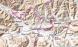
[[File:Kongka-Pass-area.jpg|thumb|right|270px|Map 1: Area around the Kongka Pass]] | |||
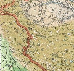
[[File:Changchenmo-Valley-map-Survey-of-India-1916.jpg|thumb|right|270px|Map 2: Map including Konka Pass (Survey of India, 1916)]] | |||
[[File:Changchenmo-Valley-map-by-US-Army-Map-Service.jpg|thumb|right|270px|Map 3: Map of the Chang Chenmo Valley and the prevailing border at India's independence ([[Army Map Service|AMS]], 1955){{efn|From map: "THE DELINEATION OF INTERNATIONAL BOUNDARIES ON THIS MAP MUST NOT BE CONSIDERED AUTHORITATIVE"}}]] | |||
The [[Chang Chenmo Valley]] lies in a depression between the [[Karakoram Range]] in the north and the [[Changchenmo Range]] in the south.{{efn|The depression continues into Tibet, all the way to [[Yeshil Kul]] (Bangda Co) and [[Lake Lighten]] (Gozha Co) on the Khotan border.<ref> | |||
{{citation |first=Emil |last=Trinkler |title=Notes on the Westernmost Plateaux of Tibet |journal=The Himalayan Journal |volume=3 |year=1931 |url=https://www.himalayanclub.org/hj/03/5/notes-on-the-westernmost-plateaux-of-tibet/}} | |||
</ref> The depression is now recognized as a geological fault called the ''Longmu Co fault'', part of the larger Longmu–Guozha Co fault system.<ref> | |||
{{cite journal |last1=Chevalier |first1=Marie-Luce |last2=Pan |first2=Jiawei |last3=Li |first3=Haibing |last4=Sun |first4=Zhiming |last5=Liu |first5=Dongliang |last6=Pei |first6=Junling |last7=Xu |first7=Wei |last8=Wu |first8=Chan |title=First tectonic-geomorphology study along the Longmu–Gozha Co fault system, Western Tibet |journal=Gondwana Research |volume=41 |year=2017 |pages=411–424 |issn=1342-937X |doi=10.1016/j.gr.2015.03.008|bibcode=2017GondR..41..411C }} | |||
</ref>}} | |||
Immediately to the north of the Chang Chenmo Valley, the Karakoram Range splits into multiple branches, with one of the branches (called "Karakoram-I" by some authors) forming a dividing ridge between the [[Kugrang River]] in the west and the [[Changlung River|Changlung]] and '''Kyapsang''' rivers in the east.{{sfnp|Johri, Chinese Invasion of Ladakh|1969|p=106}} A spur of this branch extends into the Chang Chenmo Valley for some distance, forcing the Changchenmo river to bend around it. On this spur lies the low pass of Kongka Pass, essentially forming a part of the general depression that is the Chang Chenmo valley. | |||
To all appearances, the Kongka Pass was an unimportant saddle point, while the normal travel route followed the course of the Changchenmo river. (Maps 2 and 3) However, it was also possible to travel east by ascending the pass, especially in wintertime when the river area might be icy. [[Arthur Douglas Carey]] and [[Andrew Dalgleish (spy)|Andrew Delgleish]] used the pass in 1885 in travelling from Ladakh to [[Keriya Town|Keriya]].<ref name="Carey and Dalgleish"/> | |||
Since 1959, the Kongka Pass formed part of the dividing line between India and China, China having extended its claims till this point. (Map 4) Kongka Pass is also on the dividing line between China's [[Xinjiang]] and [[Tibet Autonomous Region|Tibet]] autonomous regions. The Chang Chenmo Valley to the east of here is part of Tibet; the [[Aksai Chin]] region to the north is part of Xinjiang. China has a large military base at the bottom of the Kyapsang river valley, called the '''Kongka Shankou base''' near a saddle point called '''Mobdo La'''. (Map 3) | |||
In the Indian-controlled territory immediately to the west of Kongka Pass lie the notable [[Hot Springs, Chang Chenmo Valley|Hot Springs]] (at a location called Kyam or Kiam). This location is roughly the point where the bend in the Changchenmo river ends, and river flows due west. To the northwest of here extends the Kugrang river valley, with the campsite of [[Gogra, Ladakh|Gogra]] at short distance above. At Gogra, the Changlung river flows down and joins the Kugrang river. Indian Military has termed the Kiam Hotsprings-[[Kongka Pass]] eastward route as the '''[[Line_of_Actual_Control#Patrol_points|patrol point PP-17A]]''' (map 1).<ref name=gpp1>[https://theprint.in/diplomacy/chinese-fm-wang-yi-in-india-heres-whats-on-top-of-agenda-for-talks-between-new-delhi-beijing/2723319/ hinese FM Wang Yi in India, here’s what’s on top of agenda for talks between New Delhi & Beijing], The Print, 18 Aug 2025.</ref> | |||
To the south of the Kongka Pass, three tributaries, all called "'''Silung'''", flow down from the Changchenmo Range to join Changchenmo. From the west to east, they are referred to as ''Silung Yokma'', ''Silung Barma'' and ''Silung Kongma'' (the lower, middle and upper Silungs). Further east is another tributary called ''Stathrao''. On a tributary of Silung Kongma called '''Nyingri''' lies the route to the [[Pangong Lake]] region, via '''Kyungang La''',{{efn|Spelt as "Kyungang La" by [[Henry Strachey (explorer)|Strachey]] and "Kiung Gang La" in later British writings, the pass is known to Tibetans as '''Gyagong La''' ({{bo|t=རྒྱ་གོང་ལ|w=rgya gong la}}).<ref name=KNAB/> It is marked as "Gang Pass" on Map 2 and "Chungang La" on Map 3. Border guards from [[Rudok]] were said to have been stationed here during the summer months.{{sfnp|Maisey, Topograpy, Ethnology, Resources & History of Ladak|1995|p=30}} But later information (1898) said that they were placed in campsites in the Chumesang valley to the south of the pass.<ref>{{cite book |last=Wellby |first=M. S. |title=Through Unknown Tibet |url=https://books.google.com/books?id=_Awwo3xwkQUC&pg=PA60 |year=1898 |publisher=Lippincott |isbn= 9788120610583 |pages=60–61}}</ref>}} which was once regarded as the boundary between Ladakh and Tibet. (Map 3) At present, Silung Yokma lies in the Indian-controlled territory and the rest lie in Chinese-controlled territory.<ref>{{citation |last=Ward |first=A. E. |title=The Tourist's and Sportsman's guide to Kashmir and Ladak |publisher=Thaker, Spink & Co |date=1896 |url=https://archive.org/details/dli.csl.6082 |via=archive.org |pages=105–106, 109}} (for geographical details only; Kyungang La is spelt "Kieun-la").</ref> | |||
==Sino-Indian border dispute== | |||
[[File:1947 ROC claim line in Ladakh.jpg|thumb|right|270px|Map 3: 1947 map of [[Republic of China (1912–1949)|Republic of China]] showing Lanak La as the border]] | |||
[[File:Kongka Pass claim lines (1962).jpg|thumb|right|270px|Map 4: Chinese claim lines near the Kongka Pass: 1956 claim line in green, 1960 claim line in dark brown and 1962 cease-fire line in orange]] | |||
{{ | Colonial-era British sources state that the traditional boundary between [[Ladakh]] and [[Tibet]], accepted by both sides, was at [[Lanak La]], where the Changchenmo River originates.<ref>{{cite book |last=Wellby |first=M. S. |title=Through Unknown Tibet |url=https://books.google.com/books?id=_Awwo3xwkQUC&pg=PA78 |year=1898 |publisher=Lippincott |isbn= 9788120610583 |page=78}}</ref><ref>{{Cite journal|last=Carey|first= A. D.|journal= Proceedings of the Royal Geographical Society| volume =9|year= 1887|title=A Journey round Chinese Turkistan and along the Northern frontier of Tibet|issue= 12|pages= 731–752|doi= 10.2307/1801130|jstor=1801130|url= https://zenodo.org/record/1806393}}</ref><ref>Bower, Hamilton, ''Diary of A Journey across Tibet'', London, 1894</ref><ref>Rawling, C. G., ''The Great Plateau Being An Account of Exploration in Central Tibet, 1903, And of the Gartok Expedition 1904–1905'', p 38, London, 1905</ref> Chinese maps had recognised Lanak La as the boundary at least till 1951.<ref>{{cite journal |last1=Karackattu |first1=Joe Thomas |title=The Corrosive Compromise of the Sino-Indian Border Management Framework: From Doklam to Galwan |journal=Asian Affairs |volume=51 |issue=3 |year=2020 |pages=590–604 |doi=10.1080/03068374.2020.1804726 |s2cid=222093756}}: p. 591: "The ''Atlas of China'' (''Chung-hua jen-min kung-ho-kuo hsin ti-t’u'', published in 1951) is one of the earliest maps published by the PRC, after the Communist Party came to power. The agency accrediting the maps was the ''Zhongguo Tushu Faxing Gongsi'' (a government-approved office similar to the Ministry of Internal Affairs/Security or ''Nei Zheng Bu'' before the Communist Party came to power), and the maps clearly depict the vicinity of Lanak La as being coterminous with India, unlike Zhou En Lai’s claim line that truncated India much earlier at the Kongka Pass. Even previously published Chinese maps such as ''A New Atlas of China'' (''Chung hua min kuo hsin titu'', published in 1934), contained the “New Map of the Republic of China” on the occasion of the 60th Anniversary of ''Shenpao'' (Shanghai News), that showed India in the vicinity of the Lanak La pass (running much further eastwards than current Chinese maps show)." p. 592: Figure 1. </ref> | ||
In 1952, Indian patrol teams had reached till Lanak La without encountering any Chinese presence.<ref name="ahuja" /> When enquired in 1954 and again in 1956 about demarcating boundaries in the sector, [[Zhou Enlai]] replied that the [[People's Republic of China|PRC]] government was still printing [[Kuomintang]] maps and had not had the time to prepare their own maps. While maintaining this position, the Chinese would lay the Sianking–Tibet road (now [[G219]]) through Aksai Chin to Indian objections and even imprison a two-men strong patrol party.<ref name="Smith">{{citation |last=Smith |first=Warren W. |title=Tibetan Nation: A history of Tibetan nationalism and Sino-Tibetan relations |url=https://books.google.com/books?id=SbHtAAAAMAAJ |page=489 |year=1996 |publisher=Westview Press |isbn=978-0-8133-3155-3 |quote="Chou had assured Nehru that the PRC was still using old KMT maps, not yet having had time to prepare their own... On 8 October 1958 the Indians protested to China that the [Sinkiang-Tibet road] traversed Indian territory, to which the PRC replied that the territory in question was Chinese."}}</ref> | |||
In | In 1956, a map was published that marked Kongka Pass as the boundary in the Chang Chenmo Valley; three years hence, Zhou would note this particular map to be an accurate representation of Chinese position and claim Kongka Pass to be the "traditional customary boundary" of China.<ref name="Karackattu">{{cite journal |last1=Karackattu |first1=Joe Thomas |title=The Corrosive Compromise of the Sino-Indian Border Management Framework: From Doklam to Galwan |journal=Asian Affairs |volume=51 |issue=3 |year=2020 |pages=590–604 |doi=10.1080/03068374.2020.1804726 |s2cid=222093756}}</ref><ref>Chou Enlai, ''The Sino-Indian Boundary Question'', Foreign Language Press, Peking, November 1962. "In October 1959 Indian armed forces crossed the ''traditional customary boundary line'' in the western sector and provoked a sanguinary border clash of an even graver nature at Kongka Pass." (emphasis added)</ref> Leo E. Rose and Wim van Eekelen find such claims to be inconsistent with the available evidence.<ref>{{harvp|Fisher, Rose & Huttenback, Himalayan Battleground|1963|p=101}}: "Confusion as to the extent of the Chang Chenmo valley between the Lanak and Kongka passes continued to be a feature of Chinese cartography even after the Communists came to power.... the flexibility shown by official Chinese cartographers here and on other sections of the border makes mockery of China's oft-repeated claim that its concept of the border has a solid basis in history."</ref><ref>{{citation |last1=Van Eekelen |first1=Willem Frederik |title=Indian Foreign Policy and the Border Dispute with China |url=https://books.google.com/books?id=8eTzBwAAQBAJ&pg=PA163 |year=1967 |publisher=Springer |isbn=978-94-017-6555-8 |page=164 |quote="The Chinese could not quote a single document confirming that the Kongka Pass constituted the boundary.... The thorough approach of the Indian side generally contrasted with an inconsistent and almost careless presentation by the Chinese officials."}}</ref> | ||
The | === Kongka Pass incident === | ||
In October 1959, an Indian police party{{efn|The Indian team was made up of personnel from the [[Central Reserve Police Force]] (CRPF), who were loaned to the [[Intelligence Bureau (India)|Intelligence Bureau]] for border security and intelligence-gathering functions. They were dubbed the "India–Tibet Border Force", but they are not to be confused with the paramilitary force called [[Indo-Tibetan Border Police]], which was a later formation.}} was sent to set up posts in three locations — [[Tsogtsalu]], [[Hot Springs, Chang Chenmo Valley|Hot Springs]] and [[Shamal Lungpa]] — which were in undisputed Indian territory per the recent Chinese maps. The party was led by an [[Intelligence Bureau (India)|Intelligence Bureau]] officer of the rank of Deputy Superintendent, Karam Singh, who was an experienced patroller in Ladakh. As late as June 1958, Singh had led patrols to Lanak La without incidents.{{sfnp|Hoffmann, India and the China Crisis|1990|loc=p. 77: "This company was commanded by the most experienced Indian patrol leader in Ladakh, one Karam Singh, who (the previous June) had taken a patrol through Hot Spring, Kongka Pass, and then forty miles further to Lanak La. No sign of a Chinese presence had been seen then, but this time (October 1959) the situation would change."}}{{Relevance inline|reason=These past experiences are not relevant to the topic, only serves as narrative fluff.|date=July 2022}} Singh states that they had established a post at Hot Springs and were about to head to Shamal Lungpa when, on 20 October, two men sent out for reconnaissance went missing.<ref name="white_paper"> | |||
{{Cite book |title=Notes, Memoranda and letters Exchanged and Agreements signed between The Governments of India and China | series=White Paper |volume=III |publisher=Ministry of External Affairs, Government of India |via=claudearpi.net |date=1960 |access-date=4 January 2020 |url=http://www.claudearpi.net/wp-content/uploads/2016/12/WhitePaper3NEW.pdf |quote=[Chinese interrogation of Karam Singh] We established a checkpost at Kayam and we had to establish one at Shamul Lungpa. On 20th October 1959, our two men missed. On the morning of 21st October 1959, Tyagi took 60 men and reached the hill (battle field). ... [Indian debriefing of Karam Singh] we had inadequate cover and the Chinese were in a favourable position ... five of us were made to carry the dead body of a Chinese soldier who had been killed.}} | {{Cite book |title=Notes, Memoranda and letters Exchanged and Agreements signed between The Governments of India and China | series=White Paper |volume=III |publisher=Ministry of External Affairs, Government of India |via=claudearpi.net |date=1960 |access-date=4 January 2020 |url=http://www.claudearpi.net/wp-content/uploads/2016/12/WhitePaper3NEW.pdf |quote=[Chinese interrogation of Karam Singh] We established a checkpost at Kayam and we had to establish one at Shamul Lungpa. On 20th October 1959, our two men missed. On the morning of 21st October 1959, Tyagi took 60 men and reached the hill (battle field). ... [Indian debriefing of Karam Singh] we had inadequate cover and the Chinese were in a favourable position ... five of us were made to carry the dead body of a Chinese soldier who had been killed.}} | ||
</ref> | </ref> According to the Chinese version of the events these two men had crossed the "traditional border at Kongka Pass", leading to their detention.<ref name="wortzel">{{cite book |last=Wortzel |first=Larry |author-link=Larry Wortzel |editor1-last=Burkitt |editor1-first=Laurie |editor2-last=Scobell |editor2-first=Andrew |editor3-last=Wortzel |editor3-first=Larry |title=The Lessons of History: The Chinese People's Liberation Army at 75 |url=http://www.strategicstudiesinstitute.army.mil/pdffiles/PUB52.pdf |archive-url=https://web.archive.org/web/20051113163101/http://www.strategicstudiesinstitute.army.mil/pdffiles/pub52.pdf |url-status=dead |archive-date=13 November 2005 |year=2003 |publisher=[[Strategic Studies Institute]], [[U.S. Army War College]] |isbn=9781428916517 |page=331 |quote="In the western sector of the border, on 21 October 1959, a team of Indian troops crossed the traditional border at Kongka Pass, entering Chinese territory."}}</ref> Later information reveals that the location was on the bank of the Chang Chenmo River, somewhere between the mouth of Silung Barma and that of Silung Kongma.<ref name="Hoffmann two miles west">{{harvp|Hoffmann, India and the China Crisis|1990|loc=p. 77: "[The incident] happened two miles west of the [Kongka] pass, on the banks of the Chang Chenmo River."}}</ref> | ||
According to the Chinese version of the events | |||
On 21 October | The same evening, Singh dispatched a 10-men-strong party to investigate the disappearance, who returned late night and reported extensive hoof-marks in the region suggesting the presence of Chinese cavalry.<ref name="ahuja" /> On the morning of 21 October, a forward search party of 20 men set out on ponies under Singh; the rest was ordered to follow on foot under another commander called Tyagi.<ref name="ahuja" />{{sfnp|Sandhu, Shankar & Dwivedi, 1962 from the Other Side of the Hill|2015|p=44}} Singh chose to follow the hoof-marks near Kongka Pass and lost contact with Tyagi's men. Singh encountered Chinese soldiers on top of a hill,{{efn|According to Chinese sources, the site is a small independent hill to the south of the Chang Chenmo River, which was later named '''Shengli Hill''' ({{zh|c=胜利山|p=Shènglì shān}}; "Victory Hill").<ref name="qi">{{cite book |last1=靳 |first1=娟娟 |last2=金 |first2=天义 |date=2011-04-01 |trans-title=The Border Control and Border Construction in XinJiang |script-title=zh:新疆边防管理与边防建设 |url=http://47.94.233.156/RMBase/SysJP/Multimedia/Pdf.ashx?ID=236472&contentid=1949&form=browse |language=Chinese |location=Beijing |publisher=Social Sciences Academic Press |isbn=978-7-5097-1934-3 |quote="防守于章图山南侧一独立小高地 (胜利山)。 " |page=184 }}{{Dead link|date=June 2025 |bot=InternetArchiveBot |fix-attempted=yes }}</ref>}} who belonged to the 6th Cavalry Regiment and were well-entrenched in their position.<ref name="ahuja" /><ref name="white_paper" />{{sfnp|Sandhu, Shankar & Dwivedi, 1962 from the Other Side of the Hill|2015}} A firefight ensued after negotiations failed.<ref name="ahuja" /> Nine Indian policemen were killed during the engagement, one died later of his injuries,<ref name="bhatnagar">{{Cite magazine | ||
| title = Hot Springs: Saga of Heroism | | title = Hot Springs: Saga of Heroism | ||
| first = R.R. | | first = R.R. | ||
| Line 77: | Line 91: | ||
| pages = 16 | | pages = 16 | ||
| url = http://bprd.nic.in/WriteReadData/CMS/Spl.%20issue%20of%20IPJ.pdf | | url = http://bprd.nic.in/WriteReadData/CMS/Spl.%20issue%20of%20IPJ.pdf | ||
| quote = Fighting gallantly nine men laid down their lives and ten were wounded. Later on, one of the injured also succumbed to his injuries. ... Seven men were taken Prisoners of War by PLA}}</ref> and seven were taken prisoner | | quote = Fighting gallantly nine men laid down their lives and ten were wounded. Later on, one of the injured also succumbed to his injuries. ... Seven men were taken Prisoners of War by PLA}}</ref> and seven were taken prisoner. One Chinese soldier of the rank of "Deputy Squadron Leader" was killed too.<ref name="white_paper" /><ref> | ||
* {{Cite book|title =Communist Remembrance Historical Materials 3|last=Chinese People's Liberation Army Historical Data Series Editorial Board |publisher=Beijing:解放军出版社|year=1997|isbn=7-5065-3348-0|pages=213}} | *{{Cite book|title =Communist Remembrance Historical Materials 3|last=Chinese People's Liberation Army Historical Data Series Editorial Board |publisher=Beijing:解放军出版社|year=1997|isbn=7-5065-3348-0|pages=213}} | ||
* {{Cite book|title=The People's Republic of China's Toponymic Dictionary Volume 5|editor-last= Naifu|editor-first=Cui|publisher=Beijing:商印书|year=2002|isbn=7-100-03254-7|pages=7777}} | *{{Cite book|title=The People's Republic of China's Toponymic Dictionary Volume 5|editor-last= Naifu|editor-first=Cui|publisher=Beijing:商印书|year=2002|isbn=7-100-03254-7|pages=7777}} | ||
* {{Cite web|url=http://www.shule.gov.cn/ShowNews_Content9929.shtml|title=Shuol government information website--Shule County Martyrs Cemetery Maintenance and Reconstruction Project successfully passed the project completion acceptance|access-date=2018-05-06|work=Silele County People's Government|url-status=live|archive-url=https://web.archive.org/web/20180507010548/http://www.shule.gov.cn/ShowNews_Content9929.shtml|archive-date=2018-05-07}} | *{{Cite web|url=http://www.shule.gov.cn/ShowNews_Content9929.shtml|title=Shuol government information website--Shule County Martyrs Cemetery Maintenance and Reconstruction Project successfully passed the project completion acceptance|access-date=2018-05-06|work=Silele County People's Government|url-status=live|archive-url=https://web.archive.org/web/20180507010548/http://www.shule.gov.cn/ShowNews_Content9929.shtml|archive-date=2018-05-07}} | ||
</ref> | </ref> | ||
It appears that Tyagi's men were informed of the firefight by one of Singh's constables but they were under simultaneous attack and failed to be of any help; however, his team incurred no fatalities despite injuries on several men. On 22 October, Tyagi retreated to [[Tsogtsalu]] and four severely injured men were evacuated by air.<ref name="ahuja" /> | |||
After release, Karam Singh reported that the detained personnel were put in a storage pit for four days under severe climatic conditions without water, refused medical attention, interrogated in 12 hour stretches for further several days, induced to sign false confessions about them being responsible for the episode, window-dressed for photographs, and finally returned to India on 14 November.<ref>{{harvp|Rowland, A History of Sino-Indian Relations|1967|pp=130–131}}: 'Singh's testimony provides a good picture of Chinese interrogating technique: "This interrogation lasted from 4:00 A.M. to about 4:00 P.M. By this time I was almost frozen and mentally and physically exhausted because of cold, persistent interrogation, intimidation, threats, angry shoutings and lack of sleep. In this condition I was compelled to sign the statement recorded by the Chinese. At the end of this interrogation the Chinese then brought all the other captured personnel before me and read out the statement and several photographs were taken."... The incident was staged according to the Chinese version of events while photographs were taken which could be used as evidence in support of the Chinese allegations that the Indian patrol had provoked the incident.'</ref><ref name="ahuja"/> The bodies of the dead soldiers were returned a day earlier at the new border of Kongka Pass and China rejected payment of any compensation.<ref name="ahuja"/> Scholar John Rowland states that, through these means, China obtained the "evidence" it needed to claim that it was India that broke the [[Panchsheel agreement|Panchsheel]] (peace agreement between the two countries) unprovoked.{{sfnp|Rowland, A History of Sino-Indian Relations|1967|pp=130–131}} China however rejected Singh's testimony and charged Indian Government of promoting Sinophobic sentiments.{{Efn|The government accepted that their troops might have failed in providing optimum care for the first few days, since such an event was wholly unanticipatable.}} | |||
Indian media described the event as a "brutal massacre of an Indian police party." The incident [[Events leading to the Sino-Indian War|contributed to the heightening of tensions]] that led to the [[Sino-Indian War]] in 1962.<ref name="maxwell"> | Indian Army castigated the Intelligence Bureau for causing mindless provocations at the frontiers without bringing them in confidence and from 1 November, took charge of manning all border-posts in the sector.<ref name="ahuja" /> Throughout the time of the detention, China claimed that Kongka Pass was patrolled by their troops ever since liberation of Tibet and that the episode happened only due to unprovoked aggression by Indian side; threats were made to infiltrate NEFA if Indian patrols were to disregard Chinese claims in the Ladakh sector. Public protests called for resignation of defence minister [[Krishna Menon]] and abandonment of non-alignment as a strategic policy. Indian media described the event as a "brutal massacre of an Indian police party" with [[The Indian Express]] carrying an editorial about how Nehru had ignored the "menace of Han expansionism and Communist Imperialism."<ref name="ahuja" /> The incident [[Events leading to the Sino-Indian War|contributed to the heightening of tensions]] that led to the [[Sino-Indian War]] in 1962.<ref name="maxwell">{{cite book |title=India's China War |last=Maxwell |first=Neville |author-link=Neville Maxwell |year=1970 |publisher=Pantheon |location=New York |url=https://www.scribd.com/doc/12249475/Indias-China-War-Neville-Maxwell |page=13 |access-date=29 August 2013 |archive-date=1 November 2013 |archive-url=https://web.archive.org/web/20131101121143/http://www.scribd.com/doc/12249475/Indias-China-War-Neville-Maxwell |url-status=dead }}</ref><ref name="ahuja">{{cite news | ||
{{cite book |title=India's China War |last=Maxwell |first=Neville |author-link=Neville Maxwell |year=1970 |publisher=Pantheon |location=New York |url=https://www.scribd.com/doc/12249475/Indias-China-War-Neville-Maxwell |page=13 |access-date=29 August 2013}} | |first=Vivek |last=Ahuja | ||
</ref><ref name="ahuja">{{cite | |title=Unforgiveable Mistakes, The Kongka-La Incident, 21st October 1959 | ||
|newspaper=Security Research Review (formerly Bharat Rakshak Monitor) | |||
|date=July–December 2008 |id=BRMP07010805 | |||
|url=http://www.adl.gatech.edu/research/brmsrr/2008/BRMP07010805.pdf | |url=http://www.adl.gatech.edu/research/brmsrr/2008/BRMP07010805.pdf | ||
|archive-url=https://web.archive.org/web/20110930230542/http://www.adl.gatech.edu/research/brmsrr/2008/BRMP07010805.pdf | |archive-url=https://web.archive.org/web/20110930230542/http://www.adl.gatech.edu/research/brmsrr/2008/BRMP07010805.pdf | ||
|archive-date=30 September 2011 | |archive-date=30 September 2011 | ||
| Line 106: | Line 119: | ||
| height = 270 | | height = 270 | ||
| nolabels = 1 | | nolabels = 1 | ||
| caption = | | caption = {{center|Map 5: China's Kongka Shankou base}} | ||
<!-- Kongka Shankou base --> | <!-- Kongka Shankou base --> | ||
| mark-coord1 = {{coord|34.3341|79.1072}} | | mark-coord1 = {{coord|34.3341|79.1072}} | ||
| Line 131: | Line 144: | ||
| url = http://bprd.nic.in/WriteReadData/CMS/Spl.%20issue%20of%20IPJ.pdf | | url = http://bprd.nic.in/WriteReadData/CMS/Spl.%20issue%20of%20IPJ.pdf | ||
| quote = (p22) Karam Singh of ITBF was assigned the task of establishing outposts near the Chinese Occupation Line ... "Hot Springs" was barely three Km far from the site where Chinese Army had intruded. | | quote = (p22) Karam Singh of ITBF was assigned the task of establishing outposts near the Chinese Occupation Line ... "Hot Springs" was barely three Km far from the site where Chinese Army had intruded. | ||
}}</ref> | }}</ref> A war-memorial is situated at the place.<ref name="ahuja" /> | ||
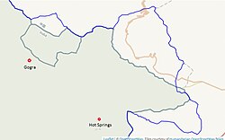
[[File:Kongka-La-snapshot-from-earthworks-stanford-edu-Gogra-Hot-Springs.jpg|thumb|right|275px|Line of Actual Control near Kongka La, as marked by the US [[Office of the Geographer]] in 2013 (in blue), and as marked by OpenStreetMap in 2020 (in green)<ref name=earthworks/>]] | [[File:Kongka-La-snapshot-from-earthworks-stanford-edu-Gogra-Hot-Springs.jpg|thumb|right|275px|Map 6: Line of Actual Control near Kongka La, as marked by the US [[Office of the Geographer]] in 2013 (in blue), and as marked by OpenStreetMap in 2020 (in green)<ref name=earthworks/>]] | ||
The Chinese [[border outpost]] is located a few kilometers to the east at an elevation of {{convert|5070|m|ft}}.<ref>{{Cite web | The Chinese [[border outpost]] is located a few kilometers to the east at an elevation of {{convert|5070|m|ft}}.<ref>{{Cite web | ||
| title = 在海拔5070米的空喀山口哨卡某边防团政委宗建明和官兵深情的拥抱 | | title = 在海拔5070米的空喀山口哨卡某边防团政委宗建明和官兵深情的拥抱 | ||
| Line 157: | Line 170: | ||
[https://earthworks.stanford.edu/catalog/stanford-yg089df0008 Detailed World Polygons (LSIB), Asia and Russia, 2013], EarthWorks, Stanford University | [https://earthworks.stanford.edu/catalog/stanford-yg089df0008 Detailed World Polygons (LSIB), Asia and Russia, 2013], EarthWorks, Stanford University | ||
</ref> | </ref> | ||
It is a mountain road that runs till the [[Tianwendian]] post in the [[Depsang Plains]]. It runs parallel to the Line of Actual Control and passes through Nischu and [[Heweitan]]. It also connects to the '' | It is a mountain road that runs till the [[Tianwendian]] post in the [[Depsang Plains]]. It runs parallel to the Line of Actual Control and passes through Nischu and [[Heweitan]]. It also connects to the ''Wenjia Road'' ({{zh|c=温加线|p=Wēn jiā xiàn}}), which leads to the [[Galwan Valley]].<ref> | ||
[https://www.openstreetmap.org/relation/11347211#map=9/34.8525/78.8269 Tiankong Xian] and | [https://www.openstreetmap.org/relation/11347211#map=9/34.8525/78.8269 Tiankong Xian] and | ||
[https://www.openstreetmap.org/relation/11347741#map=9/34.8525/78.8269 Wen Jia Road] mapped on OpenStreetMap, retrieved 22 October 2020. | [https://www.openstreetmap.org/relation/11347741#map=9/34.8525/78.8269 Wen Jia Road] mapped on OpenStreetMap, retrieved 22 October 2020. | ||
| Line 163: | Line 176: | ||
== See also == | == See also == | ||
* [[List of locations in Aksai Chin]] | * [[List of locations in Aksai Chin]] | ||
| Line 175: | Line 187: | ||
== Bibliography == | == Bibliography == | ||
* {{citation |title=Gazetteer of Kashmir and Ladak |url=https://archive.org/details/in.ernet.dli.2015.43256 |via=archive.org |publisher=Superintendent of Government Printing |location=Calcutta |year=1890 |ref={{sfnref|Gazetteer of Kashmir and Ladak|1890}}}} | |||
** {{citation |first=Lieutenant F. |last=Maisey |title=Topography, Ethnology, Resources & History of Ladak (Central Asia, Part VII, Section II) |publisher=Barbican |location=Petersfield, England |year=1995 |orig-year=1878 |url=https://archive.org/details/dli.pahar.0882 |via=archive.org |ref={{sfnref|Maisey, Topograpy, Ethnology, Resources & History of Ladak|1995}}}} | |||
* {{citation |last1=Fisher |first1=Margaret W. |last2=Rose |first2=Leo E. |last3=Huttenback |first3=Robert A. |title=Himalayan Battleground: Sino-Indian Rivalry in Ladakh |year=1963 |publisher=Praeger |url=https://archive.org/details/himalayanbattleg0000unse |via=archive.org |ref={{sfnref|Fisher, Rose & Huttenback, Himalayan Battleground|1963}}}} | * {{citation |last1=Fisher |first1=Margaret W. |last2=Rose |first2=Leo E. |last3=Huttenback |first3=Robert A. |title=Himalayan Battleground: Sino-Indian Rivalry in Ladakh |year=1963 |publisher=Praeger |url=https://archive.org/details/himalayanbattleg0000unse |via=archive.org |ref={{sfnref|Fisher, Rose & Huttenback, Himalayan Battleground|1963}}}} | ||
* {{citation |first=Steven A. |last=Hoffmann |title=Perceived Hostility and the Indian Reaction to China |journal=India Quarterly |volume=20 |number=4 |date= | * {{citation |first=Steven A. |last=Hoffmann |title=Perceived Hostility and the Indian Reaction to China |journal=India Quarterly |volume=20 |number=4 |date=October–December 1973 |pages=283–299 |doi=10.1177/097492847302900401 |jstor=45070057 |s2cid=152421080 |ref={{sfnref|Hoffmann, Perceived Hostility and the Indian Reaction|1973}}}} | ||
* {{citation |last=Rowland |first=John |title=A History of Sino-Indian Relations: Hostile Co-existence |url=https://books.google.com/books?id=NB1uAAAAMAAJ |year=1967 |publisher=Van Nostrand |ref={{sfnref|Rowland, A History of Sino-Indian Relations|1967}}}} | * {{citation |last=Hoffmann |first=Steven A. |title=India and the China Crisis |url=https://books.google.com/books?id=BpSRwC5_EPUC |year=1990 |publisher=University of California Press |isbn=978-0-520-06537-6 |ref={{sfnref|Hoffmann, India and the China Crisis|1990}}}} | ||
* {{citation |last=Johri |first=Sitaram |title=Chinese Invasion of Ladakh |url=https://books.google.com/books?id=rJs9AAAAMAAJ |year=1969 |publisher=Himalaya Publications |ref={{sfnref|Johri, Chinese Invasion of Ladakh|1969}}}} | |||
* {{citation |last=Rowland |first=John |title=A History of Sino-Indian Relations: Hostile Co-existence |url=https://books.google.com/books?id=NB1uAAAAMAAJ |year=1967 |publisher=Van Nostrand |isbn=9780442070854 |ref={{sfnref|Rowland, A History of Sino-Indian Relations|1967}}}} | |||
* {{citation |last1=Sandhu |first1=P. J. S. |last2=Shankar |first2=Vinay |last3=Dwivedi |first3=G. G. |title=1962: A View from the Other Side of the Hill |url=https://books.google.com/books?id=boBNCgAAQBAJ |year=2015 |publisher=Vij Books India Pvt Ltd |isbn=978-93-84464-37-0 |ref={{sfnref|Sandhu, Shankar & Dwivedi, 1962 from the Other Side of the Hill|2015}}}} | * {{citation |last1=Sandhu |first1=P. J. S. |last2=Shankar |first2=Vinay |last3=Dwivedi |first3=G. G. |title=1962: A View from the Other Side of the Hill |url=https://books.google.com/books?id=boBNCgAAQBAJ |year=2015 |publisher=Vij Books India Pvt Ltd |isbn=978-93-84464-37-0 |ref={{sfnref|Sandhu, Shankar & Dwivedi, 1962 from the Other Side of the Hill|2015}}}} | ||
| Line 186: | Line 202: | ||
* [https://www.openstreetmap.org/relation/11294016#map=10/34.1760/78.8773 Route to Hot Springs] (India), mapped on OpenStreetMap | * [https://www.openstreetmap.org/relation/11294016#map=10/34.1760/78.8773 Route to Hot Springs] (India), mapped on OpenStreetMap | ||
{{Xinjiang topics}} | |||
{{Mountain passes of India}} | {{Mountain passes of India}} | ||
{{Mountain passes of China}} | {{Mountain passes of China}} | ||
{{Ladakh}} | {{Ladakh}} | ||
[[Category:Mountain passes of Xinjiang]] | |||
[[Category:Mountain passes of China]] | |||
[[Category:Mountain passes of Ladakh]] | [[Category:Mountain passes of Ladakh]] | ||
[[Category:Mountain passes of | [[Category:Mountain passes of India]] | ||
[[Category:Borders of Ladakh]] | [[Category:Borders of Ladakh]] | ||
[[Category:Chang Chenmo Valley]] | [[Category:Chang Chenmo Valley]] | ||
[[Category:Aksai Chin]] | |||
Latest revision as of 18:22, 18 August 2025
| Kongka Pass | |
|---|---|
| Standard Tibetan: དགུན་ཁ་ལ | |
| Elevation | 5,171 m (16,965 ft)[1] |
| Location | |
| Location | India–China border |
| Range | Karakoram |
| Kongka Pass |
|---|
The Kongka Pass or Kongka La (Tibetan: དགུན་ཁ་ལ, Wylie: dgun kha la, THL: gün kha la[2]) is a low mountain pass on the Line of Actual Control between India and China in eastern Ladakh. It lies on a spur of the Karakoram range that intrudes into the Chang Chenmo Valley adjacent to the disputed Aksai Chin region. China claimed the location as its border in a 1956 map, and attacked an Indian patrol party in 1959 killing ten policemen and apprehending ten others. Known as the Kongka Pass incident, the event was a milestone in the escalation of the border dispute between the two countries.[3]
Name[edit | edit source]
In the Ladakhi language, Kongka (Tibetan: གོང་ཀ, Wylie: gong ka) means a "low pass or ridge, high point or rise of a plateau".[4] In the first reference we have of this pass, it was called "Salmu Kongka" and explained as a "small pass".[5]
A Tibetan name for the pass is now in circulation, as "Kongka La" (Tibetan: དགུན་ཁ་ལ, Wylie: dgun kha la, THL: gün kha la), which can be interpreted as a "wintertime pass".[2]
Geography[edit | edit source]


The Chang Chenmo Valley lies in a depression between the Karakoram Range in the north and the Changchenmo Range in the south.[lower-alpha 2] Immediately to the north of the Chang Chenmo Valley, the Karakoram Range splits into multiple branches, with one of the branches (called "Karakoram-I" by some authors) forming a dividing ridge between the Kugrang River in the west and the Changlung and Kyapsang rivers in the east.[8] A spur of this branch extends into the Chang Chenmo Valley for some distance, forcing the Changchenmo river to bend around it. On this spur lies the low pass of Kongka Pass, essentially forming a part of the general depression that is the Chang Chenmo valley.
To all appearances, the Kongka Pass was an unimportant saddle point, while the normal travel route followed the course of the Changchenmo river. (Maps 2 and 3) However, it was also possible to travel east by ascending the pass, especially in wintertime when the river area might be icy. Arthur Douglas Carey and Andrew Delgleish used the pass in 1885 in travelling from Ladakh to Keriya.[5]
Since 1959, the Kongka Pass formed part of the dividing line between India and China, China having extended its claims till this point. (Map 4) Kongka Pass is also on the dividing line between China's Xinjiang and Tibet autonomous regions. The Chang Chenmo Valley to the east of here is part of Tibet; the Aksai Chin region to the north is part of Xinjiang. China has a large military base at the bottom of the Kyapsang river valley, called the Kongka Shankou base near a saddle point called Mobdo La. (Map 3)
In the Indian-controlled territory immediately to the west of Kongka Pass lie the notable Hot Springs (at a location called Kyam or Kiam). This location is roughly the point where the bend in the Changchenmo river ends, and river flows due west. To the northwest of here extends the Kugrang river valley, with the campsite of Gogra at short distance above. At Gogra, the Changlung river flows down and joins the Kugrang river. Indian Military has termed the Kiam Hotsprings-Kongka Pass eastward route as the patrol point PP-17A (map 1).[9]
To the south of the Kongka Pass, three tributaries, all called "Silung", flow down from the Changchenmo Range to join Changchenmo. From the west to east, they are referred to as Silung Yokma, Silung Barma and Silung Kongma (the lower, middle and upper Silungs). Further east is another tributary called Stathrao. On a tributary of Silung Kongma called Nyingri lies the route to the Pangong Lake region, via Kyungang La,[lower-alpha 3] which was once regarded as the boundary between Ladakh and Tibet. (Map 3) At present, Silung Yokma lies in the Indian-controlled territory and the rest lie in Chinese-controlled territory.[12]
Sino-Indian border dispute[edit | edit source]

.jpg)
Colonial-era British sources state that the traditional boundary between Ladakh and Tibet, accepted by both sides, was at Lanak La, where the Changchenmo River originates.[13][14][15][16] Chinese maps had recognised Lanak La as the boundary at least till 1951.[17]
In 1952, Indian patrol teams had reached till Lanak La without encountering any Chinese presence.[18] When enquired in 1954 and again in 1956 about demarcating boundaries in the sector, Zhou Enlai replied that the PRC government was still printing Kuomintang maps and had not had the time to prepare their own maps. While maintaining this position, the Chinese would lay the Sianking–Tibet road (now G219) through Aksai Chin to Indian objections and even imprison a two-men strong patrol party.[19]
In 1956, a map was published that marked Kongka Pass as the boundary in the Chang Chenmo Valley; three years hence, Zhou would note this particular map to be an accurate representation of Chinese position and claim Kongka Pass to be the "traditional customary boundary" of China.[20][21] Leo E. Rose and Wim van Eekelen find such claims to be inconsistent with the available evidence.[22][23]
Kongka Pass incident[edit | edit source]
In October 1959, an Indian police party[lower-alpha 4] was sent to set up posts in three locations — Tsogtsalu, Hot Springs and Shamal Lungpa — which were in undisputed Indian territory per the recent Chinese maps. The party was led by an Intelligence Bureau officer of the rank of Deputy Superintendent, Karam Singh, who was an experienced patroller in Ladakh. As late as June 1958, Singh had led patrols to Lanak La without incidents.[24][relevant?] Singh states that they had established a post at Hot Springs and were about to head to Shamal Lungpa when, on 20 October, two men sent out for reconnaissance went missing.[25] According to the Chinese version of the events these two men had crossed the "traditional border at Kongka Pass", leading to their detention.[26] Later information reveals that the location was on the bank of the Chang Chenmo River, somewhere between the mouth of Silung Barma and that of Silung Kongma.[27]
The same evening, Singh dispatched a 10-men-strong party to investigate the disappearance, who returned late night and reported extensive hoof-marks in the region suggesting the presence of Chinese cavalry.[18] On the morning of 21 October, a forward search party of 20 men set out on ponies under Singh; the rest was ordered to follow on foot under another commander called Tyagi.[18][28] Singh chose to follow the hoof-marks near Kongka Pass and lost contact with Tyagi's men. Singh encountered Chinese soldiers on top of a hill,[lower-alpha 5] who belonged to the 6th Cavalry Regiment and were well-entrenched in their position.[18][25][30] A firefight ensued after negotiations failed.[18] Nine Indian policemen were killed during the engagement, one died later of his injuries,[31] and seven were taken prisoner. One Chinese soldier of the rank of "Deputy Squadron Leader" was killed too.[25][32] It appears that Tyagi's men were informed of the firefight by one of Singh's constables but they were under simultaneous attack and failed to be of any help; however, his team incurred no fatalities despite injuries on several men. On 22 October, Tyagi retreated to Tsogtsalu and four severely injured men were evacuated by air.[18]
After release, Karam Singh reported that the detained personnel were put in a storage pit for four days under severe climatic conditions without water, refused medical attention, interrogated in 12 hour stretches for further several days, induced to sign false confessions about them being responsible for the episode, window-dressed for photographs, and finally returned to India on 14 November.[33][18] The bodies of the dead soldiers were returned a day earlier at the new border of Kongka Pass and China rejected payment of any compensation.[18] Scholar John Rowland states that, through these means, China obtained the "evidence" it needed to claim that it was India that broke the Panchsheel (peace agreement between the two countries) unprovoked.[34] China however rejected Singh's testimony and charged Indian Government of promoting Sinophobic sentiments.[lower-alpha 6]
Indian Army castigated the Intelligence Bureau for causing mindless provocations at the frontiers without bringing them in confidence and from 1 November, took charge of manning all border-posts in the sector.[18] Throughout the time of the detention, China claimed that Kongka Pass was patrolled by their troops ever since liberation of Tibet and that the episode happened only due to unprovoked aggression by Indian side; threats were made to infiltrate NEFA if Indian patrols were to disregard Chinese claims in the Ladakh sector. Public protests called for resignation of defence minister Krishna Menon and abandonment of non-alignment as a strategic policy. Indian media described the event as a "brutal massacre of an Indian police party" with The Indian Express carrying an editorial about how Nehru had ignored the "menace of Han expansionism and Communist Imperialism."[18] The incident contributed to the heightening of tensions that led to the Sino-Indian War in 1962.[35][18]
Military posts and infrastructure[edit | edit source]
Lua error in Module:OSM_Location_map at line 1984: attempt to index field 'wikibase' (a nil value). The Indian border post is located 3 kilometres (1.9 mi) to the west of Kongka Pass at Hot Springs.[36] A war-memorial is situated at the place.[18]

The Chinese border outpost is located a few kilometers to the east at an elevation of 5,070 metres (16,630 ft).[38] Called Kongka Shankou base, it is located at the junction of the Kyapsang and Chang-Chenmo rivers. The outpost is linked to the China National Highway 219 (G219) via two highways.
- The Konghong Highway (空红线, S519), or Kongka–Hongshan Highway, runs along the Chang-Chenmo Valley via Lanak La, and meets G219 near the Sumzhi and Longmu lakes.[39]
- A new road called Kongka Shankou Highway (空喀山口公路) has been laid along the continuation of the same depression as the Changchenmo Valley on the other side of G219. It meets the China National Highway 216 (G216) near the Yueya Lake.[39]
- The Banying Highway (班应线, S520) goes south from the Kongka Shankou base to the Khurnak Plain and runs along the northern shore of the Pangong Lake till it reaches the G219 highway.[40]
The Indian government has noted that the original versions of these roads were built during 1959–1962.[41]
In addition to these, a Tiankong Highway (天空线) or Tianwendian–Kongka Highway, appears to have been constructed between 2013 and 2020. It passes through territory marked as being on the Indian side of the Line of Actual Control by the US Office of the Geographer in 2013.[37] It is a mountain road that runs till the Tianwendian post in the Depsang Plains. It runs parallel to the Line of Actual Control and passes through Nischu and Heweitan. It also connects to the Wenjia Road (Chinese: 温加线; pinyin: Wēn jiā xiàn), which leads to the Galwan Valley.[42]
See also[edit | edit source]
Notes[edit | edit source]
- ↑ From map: "THE DELINEATION OF INTERNATIONAL BOUNDARIES ON THIS MAP MUST NOT BE CONSIDERED AUTHORITATIVE"
- ↑ The depression continues into Tibet, all the way to Yeshil Kul (Bangda Co) and Lake Lighten (Gozha Co) on the Khotan border.[6] The depression is now recognized as a geological fault called the Longmu Co fault, part of the larger Longmu–Guozha Co fault system.[7]
- ↑ Spelt as "Kyungang La" by Strachey and "Kiung Gang La" in later British writings, the pass is known to Tibetans as Gyagong La (Tibetan: རྒྱ་གོང་ལ, Wylie: rgya gong la).[2] It is marked as "Gang Pass" on Map 2 and "Chungang La" on Map 3. Border guards from Rudok were said to have been stationed here during the summer months.[10] But later information (1898) said that they were placed in campsites in the Chumesang valley to the south of the pass.[11]
- ↑ The Indian team was made up of personnel from the Central Reserve Police Force (CRPF), who were loaned to the Intelligence Bureau for border security and intelligence-gathering functions. They were dubbed the "India–Tibet Border Force", but they are not to be confused with the paramilitary force called Indo-Tibetan Border Police, which was a later formation.
- ↑ According to Chinese sources, the site is a small independent hill to the south of the Chang Chenmo River, which was later named Shengli Hill (Chinese: 胜利山; pinyin: Shènglì shān; "Victory Hill").[29]
- ↑ The government accepted that their troops might have failed in providing optimum care for the first few days, since such an event was wholly unanticipatable.
References[edit | edit source]
- ↑ "Kongka La". GeoNames. Retrieved 18 September 2013.
- ↑ 2.0 2.1 2.2 "Ngari prefecture". Geographical names of Tibet AR (China). Institute of the Estonian Language. 3 June 2018. Retrieved 9 January 2020.
- ↑ Hoffmann, Perceived Hostility and the Indian Reaction (1973).
- ↑ SECMOL (7 May 2020), RangSkat Ladakhi Dictionary: Ladakhi-English dictionary
- ↑ 5.0 5.1 "Journey of Carey and Dalgleish in Chinese Turkistan and Northern Tibet and General Prejevalsky on the Orography of Northern Tibet", Royal Geographical Society (Great Britain), Supplementary Papers, J. Murray, 1893, p. 10 – via archive.org: Describing the route from Leh to Keriya: "Leaving [Changchenmo valley] shortly after the Shahidulla road turns off to the left, it ascends to the plateau by a small pass (the Salmu Kongka); descending again into the valley and crossing the Changchenmo stream. Another ascent leads up the Lanak-la Pass, and the route now lies in independent Tibet."
- ↑ Trinkler, Emil (1931), "Notes on the Westernmost Plateaux of Tibet", The Himalayan Journal, 3
- ↑ Chevalier, Marie-Luce; Pan, Jiawei; Li, Haibing; Sun, Zhiming; Liu, Dongliang; Pei, Junling; Xu, Wei; Wu, Chan (2017). "First tectonic-geomorphology study along the Longmu–Gozha Co fault system, Western Tibet". Gondwana Research. 41: 411–424. Bibcode:2017GondR..41..411C. doi:10.1016/j.gr.2015.03.008. ISSN 1342-937X.
- ↑ Johri, Chinese Invasion of Ladakh (1969), p. 106.
- ↑ hinese FM Wang Yi in India, here’s what’s on top of agenda for talks between New Delhi & Beijing, The Print, 18 Aug 2025.
- ↑ Maisey, Topograpy, Ethnology, Resources & History of Ladak (1995), p. 30.
- ↑ Wellby, M. S. (1898). Through Unknown Tibet. Lippincott. pp. 60–61. ISBN 9788120610583.
- ↑ Ward, A. E. (1896), The Tourist's and Sportsman's guide to Kashmir and Ladak, Thaker, Spink & Co, pp. 105–106, 109 – via archive.org (for geographical details only; Kyungang La is spelt "Kieun-la").
- ↑ Wellby, M. S. (1898). Through Unknown Tibet. Lippincott. p. 78. ISBN 9788120610583.
- ↑ Carey, A. D. (1887). "A Journey round Chinese Turkistan and along the Northern frontier of Tibet". Proceedings of the Royal Geographical Society. 9 (12): 731–752. doi:10.2307/1801130. JSTOR 1801130.
- ↑ Bower, Hamilton, Diary of A Journey across Tibet, London, 1894
- ↑ Rawling, C. G., The Great Plateau Being An Account of Exploration in Central Tibet, 1903, And of the Gartok Expedition 1904–1905, p 38, London, 1905
- ↑ Karackattu, Joe Thomas (2020). "The Corrosive Compromise of the Sino-Indian Border Management Framework: From Doklam to Galwan". Asian Affairs. 51 (3): 590–604. doi:10.1080/03068374.2020.1804726. S2CID 222093756.: p. 591: "The Atlas of China (Chung-hua jen-min kung-ho-kuo hsin ti-t’u, published in 1951) is one of the earliest maps published by the PRC, after the Communist Party came to power. The agency accrediting the maps was the Zhongguo Tushu Faxing Gongsi (a government-approved office similar to the Ministry of Internal Affairs/Security or Nei Zheng Bu before the Communist Party came to power), and the maps clearly depict the vicinity of Lanak La as being coterminous with India, unlike Zhou En Lai’s claim line that truncated India much earlier at the Kongka Pass. Even previously published Chinese maps such as A New Atlas of China (Chung hua min kuo hsin titu, published in 1934), contained the “New Map of the Republic of China” on the occasion of the 60th Anniversary of Shenpao (Shanghai News), that showed India in the vicinity of the Lanak La pass (running much further eastwards than current Chinese maps show)." p. 592: Figure 1.
- ↑ 18.00 18.01 18.02 18.03 18.04 18.05 18.06 18.07 18.08 18.09 18.10 18.11 Ahuja, Vivek (July–December 2008). "Unforgiveable Mistakes, The Kongka-La Incident, 21st October 1959" (PDF). Security Research Review (formerly Bharat Rakshak Monitor). BRMP07010805. Archived from the original (PDF) on 30 September 2011.
- ↑ Smith, Warren W. (1996), Tibetan Nation: A history of Tibetan nationalism and Sino-Tibetan relations, Westview Press, p. 489, ISBN 978-0-8133-3155-3,
Chou had assured Nehru that the PRC was still using old KMT maps, not yet having had time to prepare their own... On 8 October 1958 the Indians protested to China that the [Sinkiang-Tibet road] traversed Indian territory, to which the PRC replied that the territory in question was Chinese.
- ↑ Karackattu, Joe Thomas (2020). "The Corrosive Compromise of the Sino-Indian Border Management Framework: From Doklam to Galwan". Asian Affairs. 51 (3): 590–604. doi:10.1080/03068374.2020.1804726. S2CID 222093756.
- ↑ Chou Enlai, The Sino-Indian Boundary Question, Foreign Language Press, Peking, November 1962. "In October 1959 Indian armed forces crossed the traditional customary boundary line in the western sector and provoked a sanguinary border clash of an even graver nature at Kongka Pass." (emphasis added)
- ↑ Fisher, Rose & Huttenback, Himalayan Battleground (1963), p. 101: "Confusion as to the extent of the Chang Chenmo valley between the Lanak and Kongka passes continued to be a feature of Chinese cartography even after the Communists came to power.... the flexibility shown by official Chinese cartographers here and on other sections of the border makes mockery of China's oft-repeated claim that its concept of the border has a solid basis in history."
- ↑ Van Eekelen, Willem Frederik (1967), Indian Foreign Policy and the Border Dispute with China, Springer, p. 164, ISBN 978-94-017-6555-8,
The Chinese could not quote a single document confirming that the Kongka Pass constituted the boundary.... The thorough approach of the Indian side generally contrasted with an inconsistent and almost careless presentation by the Chinese officials.
- ↑ Hoffmann, India and the China Crisis (1990), p. 77: "This company was commanded by the most experienced Indian patrol leader in Ladakh, one Karam Singh, who (the previous June) had taken a patrol through Hot Spring, Kongka Pass, and then forty miles further to Lanak La. No sign of a Chinese presence had been seen then, but this time (October 1959) the situation would change.".
- ↑ 25.0 25.1 25.2
Notes, Memoranda and letters Exchanged and Agreements signed between The Governments of India and China (PDF). White Paper. Vol. III. Ministry of External Affairs, Government of India. 1960. Retrieved 4 January 2020 – via claudearpi.net.
[Chinese interrogation of Karam Singh] We established a checkpost at Kayam and we had to establish one at Shamul Lungpa. On 20th October 1959, our two men missed. On the morning of 21st October 1959, Tyagi took 60 men and reached the hill (battle field). ... [Indian debriefing of Karam Singh] we had inadequate cover and the Chinese were in a favourable position ... five of us were made to carry the dead body of a Chinese soldier who had been killed.
- ↑ Wortzel, Larry (2003). Burkitt, Laurie; Scobell, Andrew; Wortzel, Larry (eds.). The Lessons of History: The Chinese People's Liberation Army at 75 (PDF). Strategic Studies Institute, U.S. Army War College. p. 331. ISBN 9781428916517. Archived from the original (PDF) on 13 November 2005.
In the western sector of the border, on 21 October 1959, a team of Indian troops crossed the traditional border at Kongka Pass, entering Chinese territory.
- ↑ Hoffmann, India and the China Crisis (1990), p. 77: "[The incident] happened two miles west of the [Kongka] pass, on the banks of the Chang Chenmo River."
- ↑ Sandhu, Shankar & Dwivedi, 1962 from the Other Side of the Hill (2015), p. 44.
- ↑ 靳, 娟娟; 金, 天义 (1 April 2011). 新疆边防管理与边防建设 [The Border Control and Border Construction in XinJiang] (in Chinese). Beijing: Social Sciences Academic Press. p. 184. ISBN 978-7-5097-1934-3.
防守于章图山南侧一独立小高地 (胜利山)。
{{cite book}}: CS1 maint: unrecognized language (link)[permanent dead link] - ↑ Sandhu, Shankar & Dwivedi, 1962 from the Other Side of the Hill (2015).
- ↑ Bhatnagar, R.R. (November–December 2018). "Hot Springs: Saga of Heroism" (PDF). Indian Police Journal. No. Special Issue on Police Martyrdom. p. 16. ISSN 0537-2429. Retrieved 4 January 2020.
Fighting gallantly nine men laid down their lives and ten were wounded. Later on, one of the injured also succumbed to his injuries. ... Seven men were taken Prisoners of War by PLA
- ↑
- Chinese People's Liberation Army Historical Data Series Editorial Board (1997). Communist Remembrance Historical Materials 3. Beijing:解放军出版社. p. 213. ISBN 7-5065-3348-0.
{{cite book}}: CS1 maint: publisher location (link) - Naifu, Cui, ed. (2002). The People's Republic of China's Toponymic Dictionary Volume 5. Beijing:商印书. p. 7777. ISBN 7-100-03254-7.
{{cite book}}: CS1 maint: publisher location (link) - "Shuol government information website--Shule County Martyrs Cemetery Maintenance and Reconstruction Project successfully passed the project completion acceptance". Silele County People's Government. Archived from the original on 7 May 2018. Retrieved 6 May 2018.
- Chinese People's Liberation Army Historical Data Series Editorial Board (1997). Communist Remembrance Historical Materials 3. Beijing:解放军出版社. p. 213. ISBN 7-5065-3348-0.
- ↑ Rowland, A History of Sino-Indian Relations (1967), pp. 130–131: 'Singh's testimony provides a good picture of Chinese interrogating technique: "This interrogation lasted from 4:00 A.M. to about 4:00 P.M. By this time I was almost frozen and mentally and physically exhausted because of cold, persistent interrogation, intimidation, threats, angry shoutings and lack of sleep. In this condition I was compelled to sign the statement recorded by the Chinese. At the end of this interrogation the Chinese then brought all the other captured personnel before me and read out the statement and several photographs were taken."... The incident was staged according to the Chinese version of events while photographs were taken which could be used as evidence in support of the Chinese allegations that the Indian patrol had provoked the incident.'
- ↑ Rowland, A History of Sino-Indian Relations (1967), pp. 130–131.
- ↑ Maxwell, Neville (1970). India's China War. New York: Pantheon. p. 13. Archived from the original on 1 November 2013. Retrieved 29 August 2013.
- ↑ Jindal, Akash (November–December 2018). "The Story of Hot Springs" (PDF). Indian Police Journal. No. Special Issue on Police Martyrdom. pp. 20–33. ISSN 0537-2429. Retrieved 4 January 2020.
(p22) Karam Singh of ITBF was assigned the task of establishing outposts near the Chinese Occupation Line ... "Hot Springs" was barely three Km far from the site where Chinese Army had intruded.
- ↑ 37.0 37.1 Detailed World Polygons (LSIB), Asia and Russia, 2013, EarthWorks, Stanford University
- ↑ "在海拔5070米的空喀山口哨卡某边防团政委宗建明和官兵深情的拥抱". Sina Military (in 中文). 17 September 2009. Retrieved 14 December 2019.
- ↑ 39.0 39.1 Konghong Highway (China, S519) and Kongka Shankou Highway mapped on OpenStreetMap, retrieved 22 October 2020.
- ↑ Bangying Highway (China, S520) mapped on OpenStreetMap, retrieved 22 October 2020.
- ↑ India, Government of (January 1963), Chinese Aggression in Maps (PDF), Publications Division, Map 4
- ↑ Tiankong Xian and Wen Jia Road mapped on OpenStreetMap, retrieved 22 October 2020.
Bibliography[edit | edit source]
- Gazetteer of Kashmir and Ladak, Calcutta: Superintendent of Government Printing, 1890 – via archive.org
- Maisey, Lieutenant F. (1995) [1878], Topography, Ethnology, Resources & History of Ladak (Central Asia, Part VII, Section II), Petersfield, England: Barbican – via archive.org
- Fisher, Margaret W.; Rose, Leo E.; Huttenback, Robert A. (1963), Himalayan Battleground: Sino-Indian Rivalry in Ladakh, Praeger – via archive.org
- Hoffmann, Steven A. (October–December 1973), "Perceived Hostility and the Indian Reaction to China", India Quarterly, 20 (4): 283–299, doi:10.1177/097492847302900401, JSTOR 45070057, S2CID 152421080
- Hoffmann, Steven A. (1990), India and the China Crisis, University of California Press, ISBN 978-0-520-06537-6
- Johri, Sitaram (1969), Chinese Invasion of Ladakh, Himalaya Publications
- Rowland, John (1967), A History of Sino-Indian Relations: Hostile Co-existence, Van Nostrand, ISBN 9780442070854
- Sandhu, P. J. S.; Shankar, Vinay; Dwivedi, G. G. (2015), 1962: A View from the Other Side of the Hill, Vij Books India Pvt Ltd, ISBN 978-93-84464-37-0
External links[edit | edit source]
- Konghong Highway (China, S519) and Kongka Shankou Highway mapped on OpenStreetMap
- Bangying Highway (China, S520) mapped on OpenStreetMap
- Tiankong Xian connecting Tianwendian and Kongka La, mapped on OpenStreetMap
- Route to Hot Springs (India), mapped on OpenStreetMap
Template:Mountain passes of China
| History |
| ||||||||||||||||||
|---|---|---|---|---|---|---|---|---|---|---|---|---|---|---|---|---|---|---|---|
| Administration | |||||||||||||||||||
| Geography |
| ||||||||||||||||||
| Human settlements | |||||||||||||||||||
| Culture |
| ||||||||||||||||||
| Tourism and wildlife |
| ||||||||||||||||||
| Transport |
| ||||||||||||||||||
| Infrastructure |
| ||||||||||||||||||
| See also |
| ||||||||||||||||||
