Sangareddy district: Difference between revisions
imported>C1MM (Added demographics) |
m (robot: Update article (please report if you notice any mistake or error in this edit)) |
||
| Line 6: | Line 6: | ||
| settlement_type =[[List of districts of Telangana|District of Telangana]] | | settlement_type =[[List of districts of Telangana|District of Telangana]] | ||
| total_type = Total | | total_type = Total | ||
| image_skyline = 11th century Ramalingeshwara Temple, Nandikandi, Telangana, Kalyani Chalukyas - 12.jpg | | image_skyline = 11th century Ramalingeshwara Temple, Nandikandi, Telangana, Kalyani Chalukyas - 12.jpg | ||
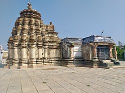
| image_caption = Ramalingeshwara temple, Nandikandi | | image_caption = Ramalingeshwara temple, Nandikandi | ||
| image_map | | image_map = {{maplink |frame=yes | ||
| map_caption | |frame-width=225 |frame-height=225 |frame-align=center | ||
|text= '''Sangareddy district''' | |||
|type=shape |id=Q28169753 | |||
|stroke-colour=#C60C30 | |||
|stroke-width=2 | |||
|title= Sangareddy district of Telangana | |||
|type2=line|id2=Q677037|stroke-width2=1|stroke-colour2=#0000ff|title2=Telangana | |||
}} | |||
| map_alt = | |||
| map_caption = Location in Telangana | |||
| coordinates = 17.780532, 77.892057 | | coordinates = 17.780532, 77.892057 | ||
| coor_pinpoint = Sangareddy | | coor_pinpoint = Sangareddy | ||
| Line 19: | Line 27: | ||
| subdivision_type2 = [[List of mandals of Telangana|Mandals]] | | subdivision_type2 = [[List of mandals of Telangana|Mandals]] | ||
| subdivision_name2 = 26 | | subdivision_name2 = 26 | ||
| established_title = | | established_title = Established | ||
| established_date = {{start date and years ago|2016|10|11|df=Y|p=y}}<ref>https://sangareddy.telangana.gov.in/</ref> | | established_date = {{start date and years ago|2016|10|11|df=Y|p=y}}<ref>[https://sangareddy.telangana.gov.in/ District Sangareddy, Government of Telangana | India<!-- Bot generated title -->]</ref> | ||
| seat_type = Headquarters | | seat_type = Headquarters | ||
| seat = [[Sangareddy]] | | seat = [[Sangareddy]] | ||
| Line 28: | Line 36: | ||
| area_total_km2 = 4996.46 | | area_total_km2 = 4996.46 | ||
| area_footnotes = | | area_footnotes = | ||
| population_as_of = | | population_as_of = 2015 | ||
| population_total = | | population_total = 1,607,244 | ||
| population_footnotes = | | population_footnotes = | ||
| population_urban = | | population_urban = | ||
| population_density_km2 = | | population_density_km2 = 378.5 | ||
| demographics_type1 = | | demographics_type1 = | ||
| demographics1_title1 = [[Literacy in India|Literacy]] | | demographics1_title1 = [[Literacy in India|Literacy]] | ||
| Line 66: | Line 74: | ||
Hindus are 81.44% while Muslims are 16.15% and Christians are 1.56% of the population.<ref name="Religion">{{cite web|title=C-16 Population By Religion - Andhra Pradesh|url=https://censusindia.gov.in/2011census/C-01/DDW28C-01%20MDDS.XLS|website=census.gov.in}}</ref> | Hindus are 81.44% while Muslims are 16.15% and Christians are 1.56% of the population.<ref name="Religion">{{cite web|title=C-16 Population By Religion - Andhra Pradesh|url=https://censusindia.gov.in/2011census/C-01/DDW28C-01%20MDDS.XLS|website=census.gov.in}}</ref> | ||
===Language=== | |||
{{Pie chart | |||
|caption=Languages of Sangareddy district (2011)<ref name="census2011-langreport">{{cite web |title=C-16 Population By Mother Tongue |url=https://www.censusindia.gov.in/2011census/C-16/DDW-C16-STMT-MDDS-2800.XLSX |work=Census of India 2011 |publisher=Office of the Registrar General |access-date=30 May 2021}} (Excludes mandals transferred to Andhra Pradesh, but includes census towns not transferred with mandals - Bhadrachalam and Sarapaka)</ref> | |||
|label1=[[Telugu language|Telugu]] |value1 = 71.97 |color1 = steelblue | |||
|label2=[[Urdu]] |value2 = 15.63 |color2 = green | |||
|label3=[[Lambadi]] |value3 = 5.03 |color3 = gold | |||
|label4=[[Kannada language|Kannada]] |value4 = 3.84 |color4 = purple | |||
|label5=[[Hindi]] |value5 = 1.76 |color5 = orange | |||
|label6=[[Marathi language|Marathi]] |value6 = 1.32 |color6 = maroon | |||
|label7=Others |value7 = 0.45|color7 = grey | |||
}} | |||
== Administrative divisions == | == Administrative divisions == | ||
Latest revision as of 14:20, 19 May 2022
Sangareddy district | |
|---|---|
 Ramalingeshwara temple, Nandikandi | |
| Coordinates (Sangareddy): 17.780532, 77.892057 | |
| Country | |
| State | Telangana |
| Mandals | 26 |
| Established | 11 October 2016[1] |
| Founded by | Government of Telangana, |
| Headquarters | Sangareddy |
| Revenue Divisions | 04 |
| Government | |
| • Type | Zilla Panchayath |
| • Body | Sangareddy Zilla Panchayath |
| • Collector | M. Hanumantha Rao, IAS |
| Area | |
| • Total | 4,996.46 km2 (1,929.14 sq mi) |
| Population (2015) | |
| • Total | 1,607,244 |
| • Density | 378.5/km2 (980/sq mi) |
| Time zone | UTC+05:30 (IST) |
| Vehicle registration | TS 15 |
| Major highways | |
| Website | sangareddy |
Sangareddy district, is a district in the Indian state of Telangana. This district contains a part of the Hyderabad Metropolitan Region.[2] The district shares boundaries with Medak, Medchal, Vikarabad, Kamareddy and Rangareddy districts and with the state boundary of Karnataka.
Geography[edit]
The district is spread over an area of 4,464.87 square kilometres (1,723.90 sq mi).[3]
Demographics[edit]
As of 2011[update] Census of India, the district has a population of 1,495,503. Scheduled Castes and Scheduled Tribes are 17.96% and 5.70% of the population respectively.[4]
Hindus are 81.44% while Muslims are 16.15% and Christians are 1.56% of the population.[5]
Language[edit]
Administrative divisions[edit]
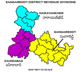
The district has four revenue divisions of Narayankhed, Sangareddy, Zaheerabad, Andole–Jogipet which are sub-divided into 27 mandals.[2] M. Hanumantha Rao is the present collector of the district.[7]
Mandals[edit]
| S.No. | Narayankhed revenue division | Sangareddy revenue division | Zaheerabad revenue division |
|---|---|---|---|
| 1 | Kalher | Ameenpur | Jharasangam |
| 2 | Kangti | Andole | Kohir |
| 3 | Manoor | Gummadidala | Mogudampally |
| 4 | Nagilgidda | Hathnoora | Nyalkal |
| 5 | Narayankhed | Jinnaram | Raikode |
| 6 | Sirgapoor | Kandi | Zahirabad |
| 7 | Kondapur | ||
| 8 | Munipally | ||
| 9 | Patancheru | ||
| 10 | Pulkal | ||
| 11 | Ramachandrapuram | ||
| 12 | Sadasivpet | ||
| 13 | Sangareddy | ||
| 14 | Vatpally |
See also[edit]
References[edit]
- ↑ District Sangareddy, Government of Telangana | India
- ↑ 2.0 2.1 "Sangareddy district" (PDF). New Districts Formation Portal. Retrieved 11 October 2016.
- ↑ "New districts". Andhra Jyothy.com. 8 October 2016. Retrieved 8 October 2016.
- ↑ District census 2011: Medak Table 13: population by Mandal
- ↑ "C-16 Population By Religion - Andhra Pradesh". census.gov.in.
- ↑ "C-16 Population By Mother Tongue". Census of India 2011. Office of the Registrar General. Retrieved 30 May 2021. (Excludes mandals transferred to Andhra Pradesh, but includes census towns not transferred with mandals - Bhadrachalam and Sarapaka)
- ↑ "K Chandrasekhar Rao appoints collectors for new districts". Deccan Chronicle. 11 October 2016. Retrieved 13 October 2016.
